|
CAPE LOOKOUT
Barrier Island Ecology of Cape Lookout National Seashore and Vicinity, North Carolina NPS Scientific Monograph No. 9 |

|
CHAPTER 3:
OVERWASH STUDIES AT CAPE LOOKOUT NATIONAL SEASHORE (continued)
GENERAL ZONATION PATTERNS (continued)
V. Salt Marshes
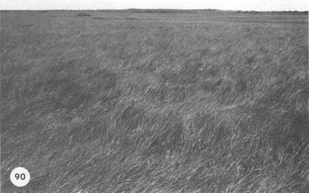
Salt marshes blend so gradually into the maritime grassland that it may be difficult to find the boundary. The marshes form on the lowest terraces, which are flooded by tides from the sound. There are two basic categories—high marsh and low marsh. The high marsh is where Spartina patens reaches its best development, with Fimbristylis spadicea as co-dominant; here the standing crop is up to 970 g/m2 and the ground cover is 100%, with S. patens accounting for 30% (Fig. 90). The high marsh is distinguished from the low marsh by being flooded only during spring or storm tides, and then usually only to a depth of a few centimeters.
|
| Fig. 90. High salt marsh on Hatteras Island. Spartina patens and the sedge Fimbristylis dominate. |
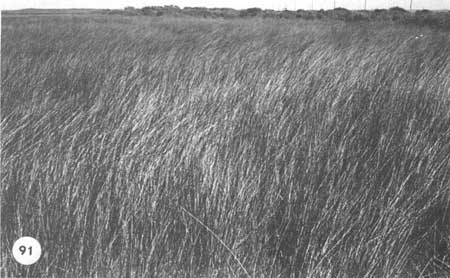
In addition to the Spartina patens-Fimbristylis type of high marsh vegetation, broad expanses are dominated by Juncus roemerianus, which, once established, aggressively crowds out everything else (Fig. 91). It withstands fresh and brackish water and normally is found in higher locations, although broad areas in the centers of marsh islands are dominated by this rush even though no change in elevation can be seen. Around the outer edges of such a Juncus stand will be the low marsh of Spartina alterniflora. The relation of this species to the other salt-marsh types is not well known at present, but it can apparently invade a Spartina marsh and eliminate the cordgrass, particularly where tidal inundation has become irregular.
|
| Fig. 91. High marsh completely dominated by black needle rush. |
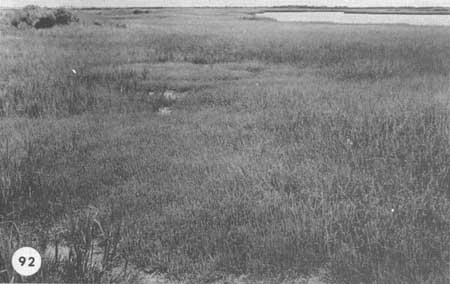
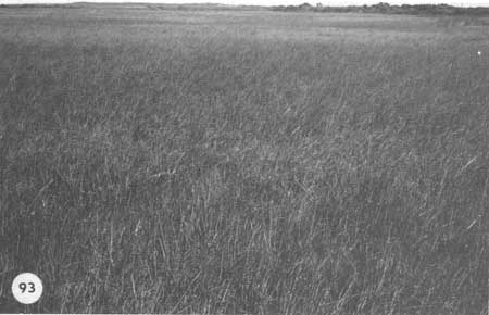
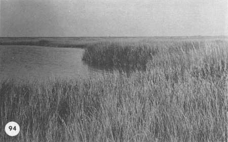
The edge of the Spartina patens-Fimbristylis vegetation usually marks the beginning of the "low marsh" dominated by Spartina alterniflora, flooded by daily tides. Between these two zones there are often "salt pannes" (Fig. 92), depressions where salt water accumulates, evaporates, and creates a highly saline habitat, dominated by halophytes such as Salicornia (glasswort). The low marsh is a generally uniform community of Spartina alterniflora, with a little Salicornia, Distichlis spicata (spikegrass), and Limonium carolinianum (sea lavender) mixed in. The productivity of the low marsh varies with its elevation; much of it is often just within reach of the tides, and here the grass is relatively short, with a productivity of around 800 g/m2 and a rather low standing crop (Fig. 93) If the edge of the marsh slopes gradually to the sound bottom, there is a zone where the grass grows luxuriantly, with high productivity near 2000 g/m2 (Fig. 94). However, this tall grass strip is often missing, particularly on marsh islands that face the prevailing winds and resulting waves which undercut and erode the edge. In such areas there is a sharp drop from the marsh surface to the sound bottom, so that roots cannot extend outward.
|
| Fig. 92. Salt panne dominated by Salicornia spp. (glasswort). between high and low marsh at Codds Creek Transect 1. Pannes are created by evaporation of salt water. |
|
| Fig. 93. Upper part of a low marsh, with the short form of Spartina alterniflora. |
|
| Fig. 94. Lower edge of a low marsh, with tall Spartina alterniflora advancing into the creek on old overwash deposits. |
The luxuriantly growing marsh edges have incredible biomass values, with culms reaching 2 m or more. This type of marsh is usually found on overwash deposits; the most productive marsh we found on Core Banks was at Codd's Creek, where about 15 years ago a bay bottom was filled in by overwash, as shown in Fig. 27. The marsh substrate is definitely beach sand sloping gradually down to the bay bottom, and provides an optimal growth surface flushed by the tides. After a few years of growth, the standing crop was twice that of the older, more typical marsh nearby. Rather than destroying estuarine resources, as some alarmists have implied, overwash increased the productivity of this marsh many times and provided a superb habitat for marine animals.
Salt marshes can thus develop in several ways and achieve varying degrees of productivity. As sea level rises, salt marshes can form on what was formerly higher land, as on Shackleford Banks, where marsh grass now surrounds old stumps (Fig. 53). Secondly, salt marshes will form where overwash sediments are poured into a bay bottom and a proper slope develops. This means that older marshes are probably buried, but these are no doubt much lower in overall productivity than the marshes which grow up on the new sediment. These overwash marshes are not particularly extensive; they only grow as fringes along the back side of the island. The third, and most extensive, marshlands are formed by inlets as described above. Since most of the marshland associated with barrier islands is apparently of this type, it is obvious that the appearance and disappearance of inlets are important to estuarine productivity for the marshes they create as well as for exchange between the sounds and the sea.
If sources of sediment are available in the sound, gradually sloping edges along the salt marshes will persist and the marshes will expand. However, the marsh surface usually grows upward by accumulation of organic matter until it nearly builds itself up out of the reach of tides. The result is low productivity and short grass. Eventually, these marshes are usually covered by overwash as the island retreats. Since the marsh is growing upward and since sediment is often in short supply, the borders of most marsh islands are breaking down. Until a new inlet forms or overwash provides new sediment, these marsh edges will continue to disintegrate.
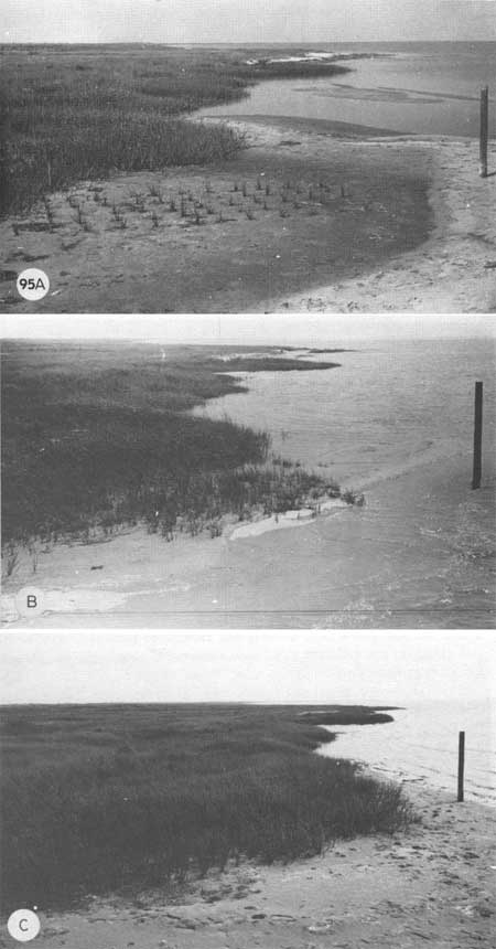
Marsh grass can readily invade new sediment brought in by overwash or the tides, either by rapid rhizome growth or by seeds. Measurements at a seawall on Core Banks near an old Coast Guard station attest to this colonization ability. In the late 1950s the station was active and had a boat basin close to the sea wall. After the abandonment of the station, overwash provided enough sediment for a salt marsh to grow up in that basin (Fig. 23); the grass is moving into the sound at about 1 m per year. In 1969 we tested whether this grass would grow in overwash sediment, and at the same time tried transplanting the grass. A 2 X 5 m plot was planted with marsh grass; within 2 years it had a density and biomass equal to that of natural marshes nearby (Fig. 95). Transplanting marsh grass is indeed practical and of increasing interest to coastal managers.
|
| Fig. 95. (A) Experimental marsh planting at the site of the Atlantic Coast Guard Station, Core Banks. Spartina plants taken from adjoining marsh were planted 0.5 m apart. (B) The same, after one growing season; all plants have survived and are spreading vegetatively. (C) The same in the summer of 1971. The grass has grown until it is indistinguishable from the natural marsh. Sand washed in from the sound has been stabilized and has raised the level of the new marsh. |
| <<< Previous | <<< Contents >>> | Next >>> |
chap3j.htm
Last Updated: 21-Oct-2005