|
CAPE LOOKOUT
Barrier Island Ecology of Cape Lookout National Seashore and Vicinity, North Carolina NPS Scientific Monograph No. 9 |

|
CHAPTER 3:
OVERWASH STUDIES AT CAPE LOOKOUT NATIONAL SEASHORE (continued)
GENERAL ZONATION PATTERNS (continued)
III. Woodland
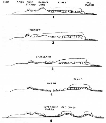
Maritime woodlands and forests can be found in five general situations as shown in Fig. 73. Type 1 (behind a barrier dune) is the most common. Here, the forest vegetation is protected from some of the salt spray and sea-water flooding by a massive seaward barrier dune. Type 2 is generally found along beaches with relatively low wave energy. Here, the forest comes down to the primary dune zone, with thicket vegetation acting as a leading edge. Type 3 can be found on low barriers well back from the beach where dune building has not been significant. Such woodlands are generally termed "hammocks" and are protected from most storms by being on the back side of the island and having a leading edge that slopes down to the land surface. Major floods can reach and damage these low woodlands. Types 4 and 5 are again hammocks with slight variation. In Type 4 the woodland is on an island which may once have been part of an inlet delta or some other land form, but is separated from the main barrier by a tidal marsh. In Type 5, the forest may exist on small dunes or dune ridges that are part of the main barrier and separated from each other by fresh-water marshes, or they may grow on small islands that were once part of a tidal delta but are now connected to the main barrier. On barriers that form as spits, a cross section across the dune ridges would show the Type 5 profile, while a section along the dune ridge would be similar to Type 1.
|
| Fig. 73. Diagrammatic cross-sections of barrier island woodland types in the vicinity of Cape Lookout National Seashore. (1) Forest growing behind a high barrier dune, which may have migrated over some of the trees. (2) Forest with thicket extending out to first dune line (3) Forest with a sloping front and a thicket type of leading edge, separated from the dunes by grassland. (4) Forest on old dunes on the high part of a marsh island, separated from the main island by salt marshes. (5) Forest on old dune ridges, with interdune freshwater marshes and ponds. |
a. Shrubland and Thicket
Woody vegetation can grow only where natural or artificial conditions protect the land from salt spray, sea-water flooding, and moving sand. Shrubland and thickets are seral stages on their way to becoming woodland, although these earlier stages can persist for a long time under the right circumstances.
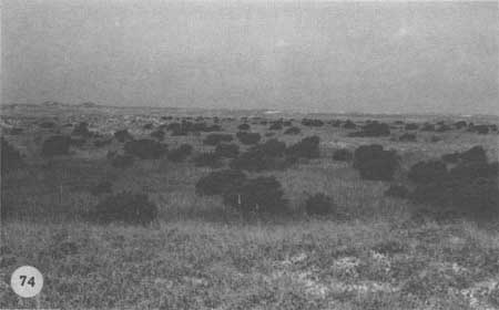
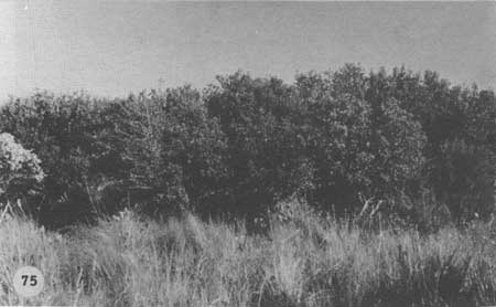
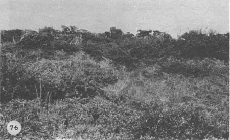
Whenever there is a period of relatively little storm flooding, scattered Myrica cerifera, Baccharis halimifolia (silverling), and Iva frutescens spring up on overwash terraces and on the high marsh (Fig. 74). Since the high marsh is flooded occasionally, this land tends to stay in the open, savanna-like shrub stage; the three main species are fast growing and soon recolonize the marsh if they are killed off by a bad storm. On overwash terraces, as the seaward dunes continue to build up, and on the more stabilized dunes, the earlier arrivals are joined by Juniperus virginiana, Zanthoxylum clava-herculis (Hercules'-club), Diospyros virginiana (persimmon), Ilex vomitoria (yaupon), several woody vines, and eventually shrubby Quercus virginiana (live oak) (Fig. 75). In time, this vegetation becomes a thicket, and often a truly impenetrable tangle (Fig. 76). Therefore, open shrubland or savanna is typical of low areas, and thickets are found on higher ground such as stabilized dunes or well-protected flats.
|
| Fig. 74. Shrub savannah on Ocracoke Island. Silverling (Baccharis) and myrtle (Myrica) are invading closed grassland. |
|
| Fig. 75. Closed shrubland on Shackleford Banks. Silverling, myrtle, yaupon (Ilex vomitoria), and red cedar are growing on overwash deposits on top of a former forest floor. (Taken in the dark area in the foreground of Fig. 77.) |
|
| Fig. 76. Densely tangled thicket on Shackleford Banks. Live oak (Quercus virginiana), red cedar, and yaupon and various vines are growing on stabilized dunes. |
On stabilized seashores such as Cape Hatteras, the shrubs and thickets have had a good chance to grow up. Miles of the "seaside highway" at Cape Hatteras pass through monotonous shrublands that handily block what vistas are left. This so frustrates visitors, as well as increasing the problem of insect pests, that the seashore management is actually taking steps to remove some of the shrubbery by cutting and burning.
b. Maritime Forest
The final stage in plant succession on stabilized barrier islands, that is, those sections of the barrier islands that are no longer under the direct influence of sea-water flooding or migrating dunes, is a woodland or forest. The term "maritime" refers to those woodlands that have developed under the influence of salt spray. Forests most similar to those on the mainland are thus on the most stabilized dunes and are protected from salt spray. Here, the trees which dominate the forest, such as live oak and loblolly pine, can attain heights comparable to those of mainland forests. At present only a few locations on the Outer Banks have an environment suitable for the survival of substantial woodlands. Good examples can still be found on the undeveloped portions of Bogue Banks (but these are rapidly being destroyed), on Shackleford Banks, around Ocracoke Village, in the Buxton area of Cape Hatteras, near the town of Avon, and in the Nags Head-Kitty Hawk region.
Maritime forests may be relicts from the time when rising sea level first isolated stabilized, wooded dune ridges from the mainland (according to the Hoyt theory of barrier-island formation). This seems to be the means by which the sea-island forests of South Carolina and Georgia were separated from the mainland, and may be the case for Bogue Banks (Burke 1962). New forests can grow up on recent land, such as an accreting spit, which Shackleford Banks appears to have once been, where the oldest dunes are stabilized and colonized by tree species. The Buxton Woods seems to have formed by a combination of processes not yet adequately explained. If dunes that develop on the shoals of old inlets grow high enough, they may be invaded eventually by woodland species and form hammocks. The woods at Guthrie's Hammock on Core Banks, Portsmouth Village, and Ocracoke Village seem to have originated this way. Where extensive overwashes have created wide terraces and a series of protective seaward dunes form, woodlands may develop as stability increases. Forest species may migrate along stable sections of the Outer Banks and then be cut off from older woodlands as the barriers migrate and change position. Rafting helps supply seeds for new woodlands; and many tree seeds, such as those of Juniperus, are carried easily by birds.
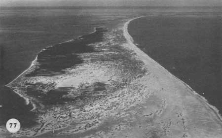
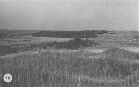
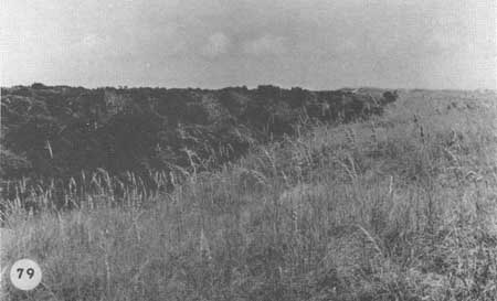
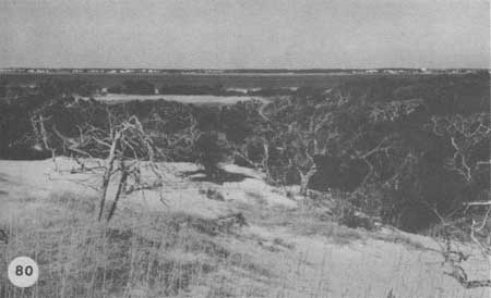
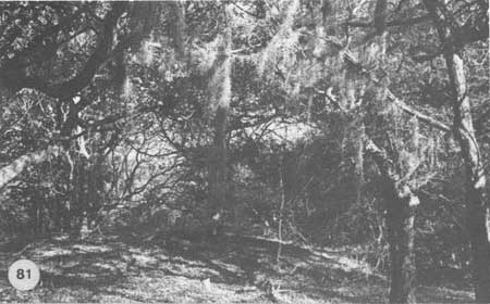
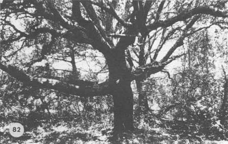
One of the best examples of maritime forest that has formed on old, curving dune lines can be seen on Shackleford Banks (Fig. 77). As mentioned earlier, a good portion of this forest was buried during the period of migrating dunes in the early 1900s. The remaining forest survives on dune lines that all curve across the island in the pattern characteristic of spit development. Wetlands of various kinds have developed between these forested dune ridges. Much of what was once moving sand dunes was stabilized by natural growth of sea oats (Fig. 78) and the living forest now survives as a remnant on the lagoon side of the new barrier dune system. That salt spray is a major factor in limiting the height of the forest canopy is evident in Fig. 79. Spray from the ocean side of the barrier dune has effectively sheared the top of the forest by killing the branches which reach upward beyond the elevation of the dune. In some places migrating sand dunes are still slowly burying the woodland and creating a new dune strand (Fig. 80). The interior of the maritime forest reflects both the effects of spray and the otherwise generally good growing conditions. Branches are relatively low to the ground and the vegetation is often a dense tangle of vines and tree limbs. Tillandsia usneoides (Spanish moss) as well as many epiphytic lichens are common on the tree branches (Fig. 81). The usual appearance of Quercus virginiana is shown in Fig. 82. While the trunk may be quite thick, the tree itself is low, with large limbs near the ground. The forest environment contrasts sharply with that of the dune strand. Here there is deep shade and less wind, and plants grow here that could never survive the open dune strand. The reduction of wind and the heavy vegetation make the forest a most unpleasant place for humans during the insect and tick season. Where extensive forests have developed on wide sections of the Outer Banks, such as Buxton Woods, the forest trees well back from the beach look no different from those on the mainland. In such places, straight, tall Pinus taeda (loblolly pine) are common and show little sign that they are on a barrier island.
|
| Fig. 77. Aerial view of the accreting west end of Shackleford Banks. Woodland of the types in Figs. 73-1 of 73-2 is growing on old dune lines. New dunes in the foreground show the same curving pattern as the older, stabilized dunes. Light gray areas in the woods are fresh marshes and ponds. |
|
| Fig. 78. General view of Shackleford forest behind the barrier dunes. Open area on left is a salt march connected with the sound. |
|
| Fig. 79. Close-up of the leading edge of the same forest. Salt spray prunes any tree which grows up above the level of the sheltering barrier dune. |
|
| Fig. 80. Many of the dunes on Shackleford Banks are stable now. but this one is still moving into the forest. Such a scene was more typical in the early years of this century. |
|
| Fig. 81. Interior of the Shackleford forest, with short live oaks and red cedars, vines (Vitis, Rhus, Smilax), and Spanish moss (Tillandsia). |
|
| Fig. 82. Large live oak in the same forest. Because of the salt spray the trees grow low with heavy branches near the ground. |
The Outer Banks maritime forest is dominated primarily by Quercus virginiana, along with Pinus taeda and Juniperus virginiana. In addition, Zanthoxylum clava-herculis, Quercus phellos (willow oak), Q. laurifolia (laurel oak), Carpinus caroliniana (hornbeam), Ilex opaca (American holly), Persea borbonia (red bay), Osmanthus americanus (wild olive) and Cornus florida (flowering dogwood) are common species in the barrier-island forest. In certain forests, such as the Buxton Woods, Pinus taeda is a most significant member of the forest community well back from the beach. Toward the beach, the more salt-resistant oaks are most important.
Besides the Tillandsia usneoides that drapes the limbs of trees, lianas commonly thread the trees together and tie them to the ground, frequently in dense tangles. These vines are mostly Smilax spp. (greenbriar), Parthenocissus quinquefolia, Vitis rotundifolia (muscadine grape), Ampelopsis arborea. Berchemia scandens (rattan-vine), Gelsemium sempervirens (yellow jessamine), and Rhus radicans (poison ivy). Shrub species below the forest canopy include such plants as Callicarpa americana (French mulberry), Ilex vomitoria, Myrica cerifera, Rhus copallina (winged sumac), Morus rubra (red mulberry), and Sabal minor (sabal palmetto) in scattered locations up to Buxton Woods.
Herbaceous plants on the forest floor are rather sparse and include such species as Uniola laxa (spike grass), a relative of sea oats, Stipa avenacea (black oat-grass), Mitchella repens (partridge berry), Bidens bipinnata (beggars ticks), Elephantopus nudatus (elephant's foot), Lepidium virginicum (poor man's pepper grass), Cnidoscolus stimulosus (spurge nettle), and various species of Panicum (Au 1969).
In addition to the epiphytic Tillandsia usneoides and vines, Polypodium polypodioides (resurrection fern) can be found on the tree trunks, as well as the parasitic Phorandendron flavescens (mistletoe). But often even more conspicuous than these higher plants are the many species of lichens which cover the branches of trees. One of the most striking is the bright orange, profusely branched Teloschistes flavicans (golden lichen); another is the grayish-green Usnea strigasa (old man's beard), and also the yellow-green, finely branched Ramalinas. Besides these branched lichens are the leafy, gray-green Parmelia and the smaller, whitish blister lichen Physcia. The most conspicuous lichen that forms a crust on the trunks of trees, particularly Ilex opaca, is the bright red Lopadium leucoxanthum (Au 1969). The most common lichens found on the ground are Cladonia cristatella (British soldiers), and other species of the grayish, finely branched Cladonia lichens generally called "reindeer moss."
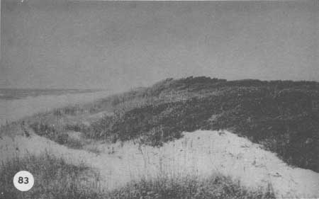
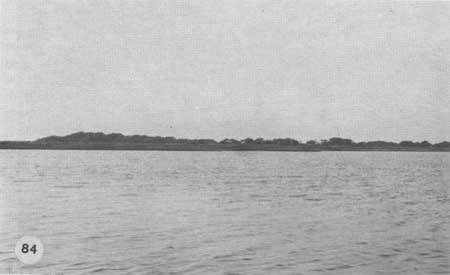
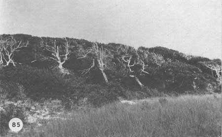
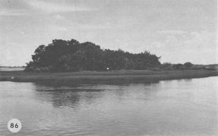
Figure 83 shows an example of the Type 2 woodland where woody vegetation extends from the maritime forest down to the fore-dune line. Here the low dunes and the thicket vegetation act as the leading edge of the forest, causing spray to be carried up and over the forest canopy. Such a profile can exist only where the dunes are still relatively stable and intact. Once storms break the fore-dunes, the woodland is subject to burial, flooding, and salt-spray damage. A large, hammock-type forest is shown in Fig. 84, Guthrie's Hammock. The ocean lies to the left of the hammock in Fig. 84 and to the right in the closeup in Fig. 85. Here, the woody vegetation slopes down to the general level of the barrier flat with no dunes in front. The aerodynamic leading edge has thus been formed by salt-spray pruning, and the trees are taller as one proceeds into the hammock from the seaward side. Figure 86 shows a typical small hammock on an island behind the Outer Banks.
|
| Fig. 83. Bogue Banks, leading edge of a forest of the type in Fig. 73-2. The thicket extends from the forest out to the first dune line; this may have been the typical pattern on Shackleford Banks in the late 1800s. |
|
| Fig. 84. Guthrie's Hammock, on Core Banks opposite Davis, North Carolina, with woodland of the type in Fig, 73-3, well back from the beach. The ocean is to the left. (Isolated stands of trees are locally called hammocks.) |
|
| Fig. 85. Leading edge of Guthrie's Hammock woods, the trees sloping to the ground. |
|
| Fig. 86. Hammock on a marsh island as in Fig. 73-4, Bogue Sound. |
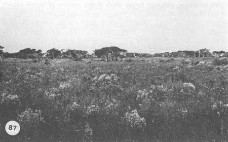
Certain hammock areas take on the aspect of a savanna vegetation such as shown in Fig. 87 near Guthrie's Hammock on Core Banks. The oaks are growing on small, old dunes that are only slightly higher than the surrounding flats of marsh and mesic meadow vegetation. Such areas bear more resemblance to the savannas of Africa than to the maritime forests of the Outer Banks.
|
| Fig. 87. Savannah as in Fig. 73-5, in the vicinity of Guthrie's Hammock. Live oaks on low dunes are surrounded by a rich closed grassland and marsh system. The flowering shrub is Baccharis. |
Interesting and varied though it is, and containing numerous plant and animal species, the maritime forest is really not adapted to the rigorous conditions that prevail over most of the Outer Banks today. Indeed, less than 20% of the surface area of the Outer Banks can be considered woodland, and this small proportion has not changed significantly over the past century, except for localized situations. Trees can only survive on the most mesic sites on the islands, where either dunes or distance protect them from moving sand, sea-water flooding, and salt spray. The best developed forests are limited to a few sections of the Outer Banks that have had a long history of dune building and general accretion, most notably where the beaches lie across prevailing winds. Most other areas of the Outer Banks have hammock-type forests located well back from the beach on old tidal delta deposits or extensive old overwash surfaces.
Slight changes in environmental conditions can eliminate woodlands, as has been seen in various locations where storms or other stresses broke the leading dune lines and sand began burying the forests. Where trees are protected they can grow rather rapidly. The growing season is long and water and nutrients (primarily from salt spray) are adequate to produce trees of 30 cm dbh in 50 or 60 years. The oldest tree we found was a hundred-year-old cedar; some Quercus virginiana may be older but their centers are usually too rotten to sample with an increment borer. One possible reason for the claim that ancient trees exist on the Outer Banks is that coastal trees frequently have "false rings," which form during drought or heat stress, in each annual growth increment. Without a microscope, a casual counter of rings in a cut tree would be likely to count these false rings. In some cases, as many as five or six false rings can be found in a single season's growth, leading one to think that a relatively young tree is very old.
| <<< Previous | <<< Contents >>> | Next >>> |
chap3h.htm
Last Updated: 21-Oct-2005