|
CAPE LOOKOUT
Barrier Island Ecology of Cape Lookout National Seashore and Vicinity, North Carolina NPS Scientific Monograph No. 9 |

|
CHAPTER 3:
OVERWASH STUDIES AT CAPE LOOKOUT NATIONAL SEASHORE (continued)
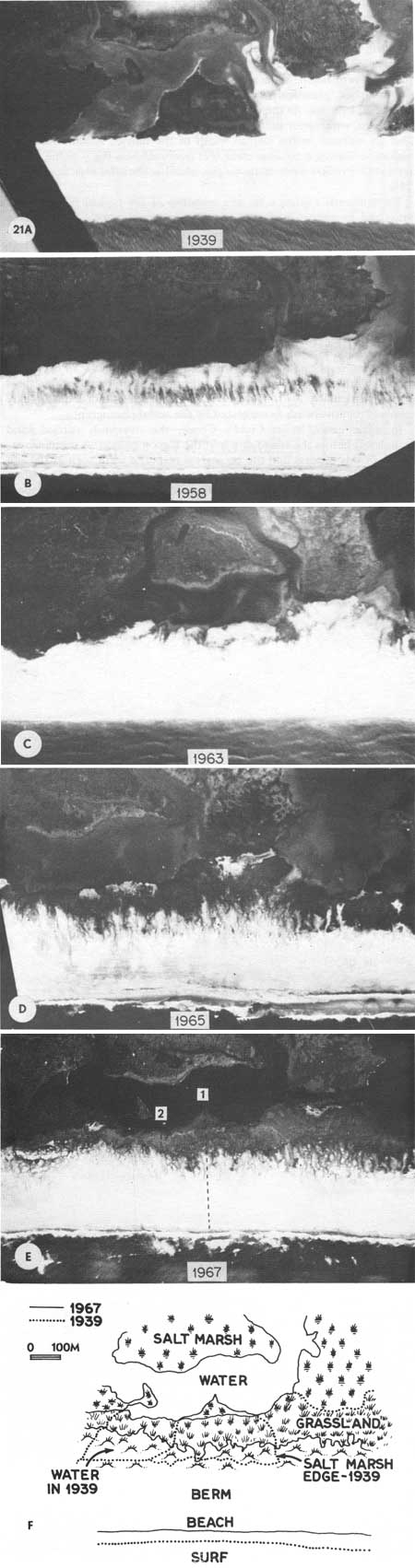
A series of photographs dating from 1939 shows graphically the pattern of overwash on a section of Core Banks called Codd's Creek (Fig. 21). Before 1968, a large bay reached toward the barrier beach around a triangular marsh peninsula. Following the severe storms of the late 1950s and early 1960s, a great deal of sand was moved across the island, onto the marsh surface, and into the bay. In the decade since, there has been a continuous build-up of the vegetation on the island; note the enlarging dark patches in the photographs.
|
| Fig. 21. Changes caused by overwash on Core Banks at Codds Creek. (A) The first photograph, taken in 1939, shows an arm of Codds Creek extending well into Core Banks. The large black triangle in the center is salt marsh. Earlier overwash, seen on right, filled in the creek between Core Banks and a marsh island. (B) Storms in the 1950s pushed sand across Core Banks, filled in the creek on the left, and covered part of the marsh, leaving a small triangle at the edge of the new deposit. It was during this time that livestock were removed from the islands. (C) By 1963. vegetation, probably marsh, began invading the new surfaces, as seen by the darkening in the photograph. (D) Recovery was well advanced in 1965, with grasslands, new dunes, and marshes reestablished. White areas at the edges of the overwash were probably salt pannes. (E) A whole new sequence of vegetation zones had completely covered the island up to the new dune line by 1967, and this is how the island appeared in 1972. All signs of earlier overwash have been erased; the banks are widened and in part connected to former salt marsh islands. Dotted lines in the photograph indicate transects discussed in the text and shown in further illustrations. (F) Overlay of outlines from 1939 and 1967 showing changes in Core Banks in that time interval. The beach retreated somewhat, while sand pushed back into former water areas is now vegetated. |
Figure 21F summarizes changes during the 28 years since the first pictures were taken. Where there was once open water, there are now salt marshes, grasslands, and dunes. Formerly bare areas have been colonized by grass. As the beach retreated, new land was formed behind the island, with upper parts of the old marsh being covered. There was also an increase in the overall width of the barrier island. With such historic evidence it became clear that overwash was the way the islands retreated. Profiles were made on the island at the sites indicated in Fig. 21E.
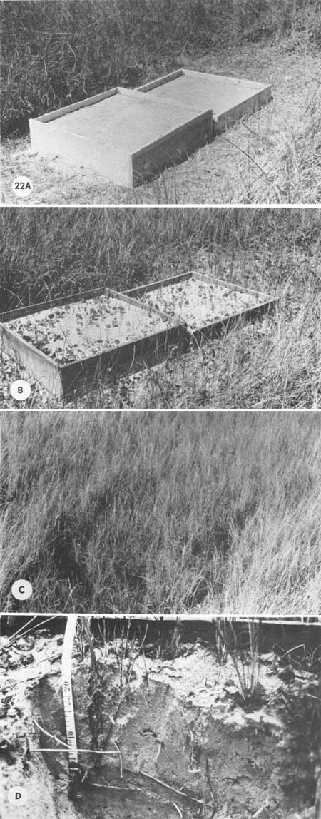
Experimental evidence for the response of the typical barrier-island grassland to overwash was obtained from experimental burial boxes. These were set up near Codd's Creek in the flat grasslands behind the dune zone where the vegetation was dominated by Spartina patens (salt meadow cordgrass). The boxes were 1 m2 and filled to depths of 10 and 20 cm with clean, root-free sand. In the case shown in Fig. 22, the grass land was first clipped. Within one growing season (Fig. 22B), Spartina patens and Hydrocotyle bonariensis (pennywort) began invading the sand. After two growing seasons, the boxes were nearly invisible, so densely did the vegetation colonize the boxes (Fig. 22C). Excavating the sand within the burial boxes showed that the main method of recolonization was the upward growth of rhizomes, primarily of Spartina patens, and rerooting near the surface. Figure 22D shows an excavated section with the orial surface indicated. Such response by these plants, particularly Spartina, verified that this grassland could quickly recover from overwash as suggested by the aerial photographs.
|
| Fig. 22. Response of grassland vegetation to a simulated overwash. (A) Meter-square boxes placed on clipped grassland with a control on the right. The boxes were filled to 20 cm or 10 cm with clean beach sand free of roots and rhizomes, June 1970. (B) By the end of the 1970 growing season, Spartina patens, Scirpus, and Hydrocotyle had pushed back up through the overlying sand. (C) A year later, August 1971, the boxes were nearly obscured by grass regrowth. The standing crop in the 10 cm burial was close to that in the control; in the 20 cm box it was somewhat less. (D) Excavation of the boxes shows the original level of the grassland (knife) and the response of Spartina patens the most important member of the grassland vegetation, to burial. Rhizomes pushed up through the sand from rootstocks below, sent out new roots near the surface, and revegetated the surface. All culms excavated in the boxes were the result of rhizome growth. Such grasslands appear capable of quick recovery from the deep burial of major overwashes. |
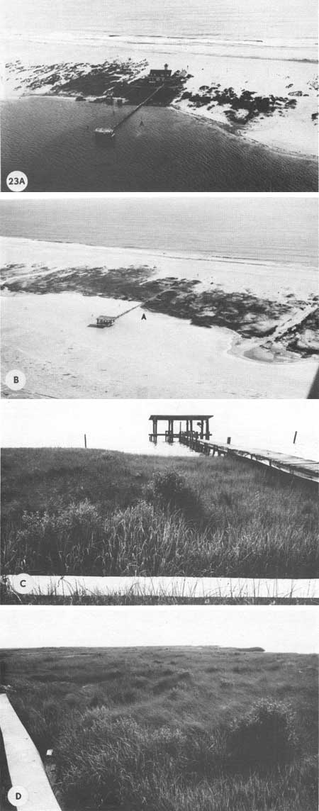
In some cases, as at Codd's Creek, the overwash carried sand completely across the island and into the lagoon behind. A dramatic example of this process and the ecological response were seen at the site of the old Atlantic Coast Guard Station on Core Banks opposite Atlantic, N.C. Figure 23A shows the station in 1962 just after it was abandoned. Up to that time, the sound behind the station was dredged for boat access; the small arrow indicates a mooring post. The station site in 1971 is shown in Fig. 23B. In the few years since maintenance ceased, overwash sand has filled the lagoon so that new marshes are developing. Note the same mooring post indicated by the arrow. Figure 23C shows the old sea wall in the foreground, the dock, and the new salt marsh that formed where once boats were moored. The post in the left background is the one marked by an arrow in the aerial photographs. Figure 23D is a view along the back side of the island, showing the extent of the new salt marsh with the sea wall on the left. Such evidence clearly illustrates the manner in which the back sides of the island grow into the sound, and new salt marshes form, as the ocean side retreats. At this particular site, marshes are growing into the lagoon at about 1 m per year.
|
| Fig. 23. (A) The Atlantic Coast Guard Station on Core Banks as it looked in 1963. At this time, several years after abandonment, the sound waters still ran up to the sea wall just behind the station. A mooring post is shown by the arrow, (B) The same area in Fig. 23A as it looked on 22 January, 1970. (The station burned in 1968.) The sound behind the sea wall has filled in and salt marsh has developed on the natural fill. The old sea wall is still visible, and the arrow shows the same mooring post in Fig. 23A. The overwash fan shown in the lower right corner of Fig. 23A increased in size, as seen here, and is now becoming salt marsh. Vegetative cover, both marsh grass and higher elevation grasslands, has increased more dramatically. The base on which the marsh is developing has been derived primarily from overwash deposition, and in this manner salt marsh will expand behind the barrier island. An experimental grass planting was made near the mooring post shown by the arrow, (See Figs. 95, 96, 97 for ground views of this planting.) (C) View of the new salt marsh growing up in what was once the harbor shown in Fig. 22A. The sea wall is in the foreground. Mooring posts are those visible in the aerial photographs. (D) The extent of the new marsh on what was sand a decade ago can be seen in this view looking south with the sea wall on the left. |
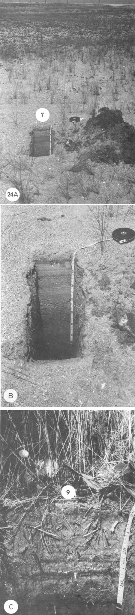
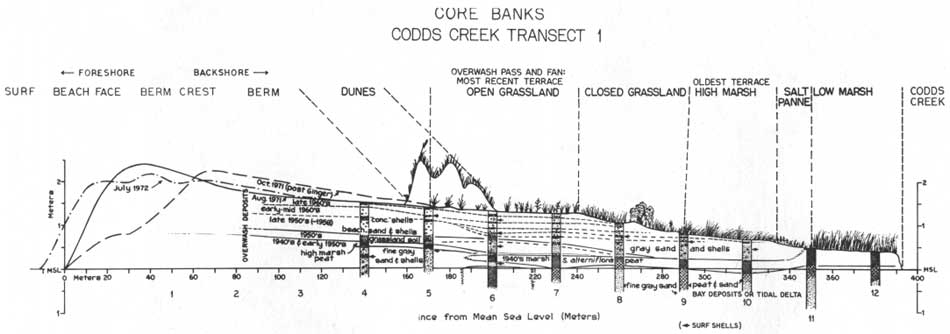
Ground surveys at Codd's Creek (Fig. 21) were made by means of vegetation transects, mapping, elevational survey, soil profiles, and geological coring. The ecological data will be discussed in the section dealing with ecosystems. Piston cores were taken 30 m apart across the island, down to 2 m where possible. Each core was diagrammed and photographed, and subsamples from each core were saved for analysis. Mollusk shells were identified from selected sections of certain cores. There is a general thinning of sand strata toward the back of the island, which shows the varying effectiveness of storms in moving sand back, with the most severe storms moving sand the farthest. Invariably, however, an organic layer was found somewhat below the surface in the middle of the island, corresponding to organic strata that now exist at the back of the island (Fig. 24). At one point, indicated on the diagram, the surface of a grassland community, probably a high marsh, was covered by nearly 1 m of sand (Fig. 25). This grassland was shown on topographic maps of the late forties and was part of the marsh shown in Fig. 21A. The presence of oceanic shells in these strata suggests that the sand indeed came from the beach. Five species of oceanic mollusks (Spisula solidissima, Donax variabilis, Mactra fragilis, Dentalium laqueatum, Anatina plicatula) were found in the strata above and below the organic horizons. This clearly shows that the upper layers of this barrier island have been deposited by overwash; wind alone is ruled out since shells weighing up to 0.5 kg were found at different levels through the interior of the island. An accumulation of 1 m of sand in 25 years is rather rapid land building.
|
| Fig. 24. Two profiles on Codds Creek Transect #1, illustrating the overwash strata which overlie organic layers. (A) Profile at Position CC 7, showing an overall view of an overwash pass with dunes in the background. This area was a marsh in the 1940s, (B) Close-up of 60 cm of strata overlying an organic layer, probably from an old grassland. The alternation of concentrated shells with sand represents successive overwashes. Layers of concentrated shells were probably surfaces from which fine sands were blown away. Water in the pit is fresh. At a depth of about 1 m salt marsh peat was found. The large whelk was found at the bottom of the pit. (C) Close-up of strata at position CC 9 in the high marsh vegetation zone. Yellow beach sand layers overlie dark gray sand (a reducing environment with black stains caused by iron sulfides). Ground water is nearly fresh. Dark bands at 13 cm are ilmenite. |
|
| Fig. 25. Diagrammatic cross-section of Core Banks (Transect 1), showing location of cores and general strata through the island surface. Reconstruction of surfaces in hypothetical, based on interpretation of aerial photographs and gross differences between strata. A high proportion of shells was taken to indicates former surface. Since there are so many such horizontal strata, the island mass plainly consists entirely of overwash deposits. Earlier marsh layers are below these recent strata. In core 8, two marsh surfaces were located, one above another and separated by overwash sediments. The overwash killed part of the marsh, while the uncovered portion continued to grow vertically. This probably caused the difference in elevation of the two surfaces. Also the weight of the overlying sand probably caused some compression of the marsh peat. Arrows indicate selected samples from which surf shells such as Donax variabilis, Anatina plicatula, and Spisula solidissima were identified. The diagram also shows the effect of Hurricane Ginger in changing the August 1971 berm profile. (See Fig. 29). The July 1972 profile clearly shows the recovery of the normal berm shape 10 months after a major storm; the sea level even moved 10 m seaward of its position in 1971. (click on image for an enlargement in a new window) |
| <<< Previous | <<< Contents >>> | Next >>> |
chap3b.htm
Last Updated: 21-Oct-2005