|
ROCKY MOUNTAIN
Mountaineering in the Rocky Mountain National Park |

|
PART 2.—THE PEAKS AND HOW TO REACH THEM—METHODS OF APPROACH, TRAILS AND REPORTS OF CLIMBS, GIVING STARTING POINT, ROUTE FOLLOWED, TIME REQUIRED, AND OTHER DATA. (continued)
PEAKS OF THE MUMMY RANGE.
The Mummy Range takes its name from a fancied resemblance to an Egyptian mummy. As seen from Longs Peak or other points to the south, the profile of Mummy Mountain forms the head, Hagues Peak forms the foot, and the rest is left to the imagination.
On some of the early maps the name of Hagues Peak was applied to the point now called Mummy Mountain, but the naming shown on the Geological Survey map will doubtless be followed in the future, and is used here. Hallett Glacier (elevation, 13,200 feet) is frequently made the objective of a trip. It is north of and close to the summit of Hagues Peak (13,562 feet). The present snow and ice field vividly suggest the mighty glacier that in bygone ages helped to carve the peaks of the Mummy Range. Hagues Peak is the highest point of the range.
An automobile road starts from Estes Park village (7,550 feet) near the Elkhorn Lodge, passes up the valley of Fall River, through Horseshoe Park (8,600 feet), and thence to the present terminus of the road to Grand Lake. The four following trails approach the Mummy Range, and may be used by saddle horses:
1. Fall River trail.—This extends beyond the present end of the road and leads to Grand Lake. To reach the Mummy Range the route follows the road as far as the ranger station (elevation, 10,500 feet), from which point Mount Chapin (12,458 feet), Mount Chiquita (13,052 feet), Ypsilon Mountain (13,507 feet), and Mount Fairchild (13,502 feet) may be climbed. Any, or even all, of these peaks may be climbed in one day by this route.
. 2. Ypsilon Lake trail.—This trail branches off from the Fall River road at the upper end of Horseshoe Park, and reaches an elevation of 10,800 feet. The end of this trail is within 2 miles, in an air-line, of the top of Mount Chiquita and Ypsilon Mountain. The east side of these peaks is steep and in places precipitous, but one may pick out a route to the top.
3. Roaring River trail.—This trail is the one most frequently used. It branches from the Fall River road at the same point as the Ypsilon Lake trail and follows up the valley of the Roaring River to Lawn Lake (10,900 feet). There is a cabin at Lawn Lake that is maintained by one of the hotels in Horseshoe Park, and one can ascertain before starting just what accommodation is available. The horse trail ends a short distance beyond Lawn Lake. Mount Fairchild, (13,502 feet), Hagues Peak (13,562 feet), or Mummy Mountain (13,413 feet) may be climbed in one day from Estes Park, but it facilitates the trip to camp at Lawn Lake and climb one or more of the peaks the following day. Hallett Glacier may be easily reached from Hagues Peak.
Bighorn Mountain (11,473 feet) may be climbed from Horseshoe Park or from a higher point on the Roaring River trail, and Mount Tileston (11,244 feet) is of easy access from the upper portion of the trail.
4. Trail up North Fork of Thompson River.—Hallett Glacier and the north portion of the Mummy Range may be reached via road through Devils Gulch (not on map) thence up the north fork of the Thompson River and by trail to Lost Lake (10,500 feet). Horses may be taken beyond Lost Lake and to within about a mile (half-hour walk) of Hallett Glacier.
Mount Dunraven (12,548 feet) and Mount Dickinson (11,874 feet) may be reached either from the trail up the north fork of the Thompson or from the trail that follows the divide between Fox Creek and West Creek. This trail is overgrown and seldom used.
The trail shown on the map up Black Canyon has been closed to protect the water supply of Estes Park village.
|
|
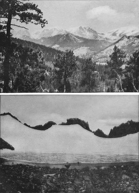
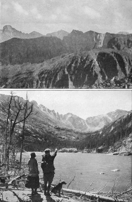
PLATE XIII. THE MUMMY RANGE. Photograph by G. H. Harvey, jr. The peaks from left to right are Mount Chapin, Mount Chiquita, Ypsilon Mountain, and Mount Fairchild. HALLETT GLACIER ON HAGUES PEAK, MUMMY RANGE. Photograph by W. T. Lee. |
MUMMY MOUNTAIN (13,413 FEET).
[Report furnished by Arnold Emch.]
By automobile in 30 minutes from Estes Park to Fall River Lodge. Walk on to the point where the trail to Lawn Lake branches off from the road. Some distance up, the trail to Ypsilon Lake branches off to the left. The distance from Fall River Lodge to Lawn Lake is something like 5-1/2 miles, and the altitude to be overcome in this distance is about 2,400 feet. The time required is from two to three hours. There is a lodge at Lawn Lake (10,900 feet). Accommodations and cooking facilities there are primitive. Visitors may, if they wish, pay for lodging only and provide their own food.
Although the summit of Mummy Mountain is almost directly north of Lawn Lake Lodge, a direct ascent from here is advisable only for experienced rock climbers. The ordinary and easy route is along the trail which continues from the cabin up to the grass-covered ridge opposite Crystal Lake. From here it is advisable to ascend the rock-covered slopes on the right side of the creek which, on the map, is shown to come from figure 2 of 13,562. In this manner the ledges of the southeastern wall of Mummy Mountain are avoided. After these have been passed, it is not difficult to reach the saddle between Hagues Peak and Mummy Mountain. The time from the Lodge to the saddle may be set at about two and a half hours. From here the top of Mummy Mountain can be reached without difficulty in half an hour.
Instead of going down to Lawn Lake by way of the saddle, Hagues Peak may easily be made on the same day. Starting from the saddle, and following the ridge, Hagues Peak may be reached in about one and a half hours. Conversely, Hagues Peak first and Mummy Mountain afterwards is a very good combination for a one-day trip, starting from Lawn Lake and ending at Estes Park.
HAGUES PEAK (13,562 FEET).
[Report furnished by Arnold Emch.]
Follow the trail from Lawn Lake up the ridge opposite Crystal Lake. Instead of going over to the saddle between Hagues Peak and Mummy Mountain, climb the ridge at about the point marked by the letter a in the word Hagues on the map. From here follow the ridge to the top of the mountain, which from Lawn Lake may easily be accomplished in about three hours. From the top it is possible to descend to the glacier without difficulty. This will require from one to two hours (including return to the ridge), according to the time spent in visiting and exploring various parts of the glacier.
The crevasses in the ice are not well developed in the early summer, and do not show up clearly until the beginning of September. This glacier and all others of this region are mere rudiments of former huge ice streams. Hagues Peak is the highest point in the Mummy Range, and affords interesting but easy rock climbing near the top of the peak.
HALLETT GLACIER AND HAGUES PEAK (13,562 FEET).
HORSEBACK TRIP VIA LOST LAKE. AUGUST, 1915.
(Report furnished by Robert Collier, jr.]
Party, 7 women, 7 men, 15 horses.
From Estes Park the party rode east to Devils Gulch. At a point near Glen Haven we went west and north, following an old log road along the north fork of the Big Thompson River for about 2 miles. Then the trail led over to the North Fork Road. About 2.30 p. m. the party came to the beautiful waterfalls of the North Fork. This well-forested canyon is one of the most beautiful in the park, and one that is very seldom visited. Several bad bogs were encountered, making it difficult for the horses. Some grouse were seen, but no other animals of note. The trail at times would emerge from the dense forest into little Alpine meadows.
The night was spent at Lost Lake. At the next morning all were up. Frost was heavy, and the creek showed signs of ice. After breakfast a couple of horses that knew enough not to be caught delayed matters for some time, but finally at 7.30 a. m. we started for the glacier.
We started south and climbed onto the moraine, which we followed as far as possible with the horses. A beautiful view of Lake Rusted, Lake Louise, and Lost Lake was obtained from the moraine. We left the horses at 9 a. m., and walked to the glacier, about a mile distant, arriving there in half an hour. On the way up a fine view of the Sherman Hills of Wyoming was obtained. The lake at the foot of the glacier (elevation 13,200 feet) was frozen, and the ice made a wonderful sight, being colored in many places by beautiful red and blue tints. After a stop at the lake the party went on to the glacier in search of a crevasse. At first sight none were to be seen, but one was finally found that proved to be very beautiful. A small opening led into an immense grotto. It was at least 50 feet high, 100 feet long, and 40 feet wide. From the walls and ceiling hung the most beautiful ice formations. The walls were coated with a heavy white frost that glistened wonderfully when the sun was reflected into this cavern. The ice on the roof had been tilted at various angles and the floor was built up in curious shapes.
From here some of the party returned direct to the horses, while seven of us went to the top of the glacier. Here a most wonderful view was obtained of the Poudre Valley, Clarkes Peak, the Medicine Bow Range, Sherman Hills, North Park, and as far south as Grays and Torreys Peaks. George Barnard and Clyde Smedley climbed Hagues Peak (elevation 13,562 feet) from this point, while the rest of the party returned to the glacier, sliding down most of the way on the snow slope. The horses were reached at noon and we stopped for lunch.
The return start was made at 1 p. m. The divide between Lost Lake and Fox Creek was followed. Here, to avoid a big bowlder field, we descended too low, thus forcing a partial return and a loss of one hour. Finally the old Divide Trail between Fox Creek and West Creek was picked up at 4.10 p. m. We had been traveling three hours above timber line. The trail led down a beautiful timbered slope for a long way. As the trail got down, it gradually became blind. Evidently few people ever use this trail and all of the blazes are overgrown, making it difficult to follow. At last, at 7.30 in the evening, we reached the wagon road about 1-1/2 miles from Glen Haven. From here on we traveled in the dark, reaching Estes Park at 9.30 p. m.
MOUNT FAIRCHILD (13,502 FEET).
[Report furnished by Arnold Emch.]
From Lawn Lake follow the trail in the direction of Hagues Peak. Cross the creek directly east of the ridge of the rock wall north of Crystal Lake; then follow the ridge up to Mount Fairchild, crossing the place marked by letter A in the word Lake on the map, and reach the top over the northern face without difficulty in about two and a half hours. The direct ascent through the gorge of Crystal Lake is possible, though probably difficult. The descent can be made over the same route as the ascent, or down to the saddle between Mount Fairchild and Ypsilon Mountain.
YPSILON MOUNTAIN (13,507 FEET).
[Report furnished by Arnold Emch.]
It is possible to climb down from Mount Fairchild to the saddle between that peak and Ypsilon Mountain in about 45 minutes. Likewise, from the saddle, the top of Ypsilon Mountain may be gained in 45 minutes. On this interesting traverse the rugged ridge between the two mountains must, in the main, be followed. The route to be followed is something like a semicircle, and it requires some steep, although not difficult, rock climbing. The elevation of the saddle is about 500 feet lower than the summits. The last portion of the ascent, over the northern ridge, is over a relatively smooth rock field. The east wall of Ypsilon Mountain is precipitous and is cut by two steep and narrow gulches, filled with snow and ice, which, below, converge to a common branch. These snow-filled gulches resemble the Greek letter Ypsilon in shape and give the mountain its name.
MOUNT CHIQUITA (13,052 FEET).
[Report furnished by Arnold Emch.]
From Ypsilon Mountain Mount Chiquita is, of course, in full view and is reached by following the crest of the watershed that connects the two mountains. From Ypsilon Mountain one has to descend about 600 feet to the saddle, and from here rise again 150 feet or so to the summit of Mount Chiquita. The whole traverse is an easy walk and requires about 45 minutes' time. Those who do not care to continue in the direction of the less important Mount Chapin, but desire additional variety are recommended to descend over the picturesque southeast ridge of Mount Chiquita. This ridge crosses the letter M in the word Mountain on the map and is left just about midway between the letters M and O. From here go toward the small lake directly south of Ypsilon Lake (on the map) and after crossing a bowlder field above the small lake the Ypsilon Lake trail appears. The time from Mount Chiquita to this trail is about one hour.
On our traverse from Mount Fairchild to Mount Chiquita and down to Ypsilon Lake trail, the time was as follows: Lawn Lake, 6 a. m.; Mount Fairchild, 8.30; saddle, 9.45; Ypsilon Mountain, 10.45; Mount Chiquita, 12 (noon); Ypsilon Lake trail, 1; Fall River, 2.30; Estes Park, 5.30 p. m. This traverse is one of the finest one-day climbing tours in the Estes Park region and can be highly recommended to energetic climbers.
MOUNT CHAPIN (12,458 FEET),
[Report furnished by Arnold Emch.]
Mount Chapin may be reached from Mount Chiquita in about half or three-quarters of an hour. Descent to the shelter cabin will take about one hour. The shelter cabin is a good starting point for the climb of Mount Chapin, Mount Chiquita, and Ypsilon Mountain. The entire traverse, including the climbing, in one day, of all peaks from Hagues Peak to Mount Chapin, or conversely, is not at all impossible, for energetic mountaineers.
MUMMY MOUNTAIN (13,413 FEET), MOUNT FAIRCHILD (13,502 FEET), AND YPSILON MOUNTAIN (13,507 FEET).
(Report furnished by Roger W. Toll (Sept. 19, 1915).]
Started from Estes Park village at midnight intending to climb Mummy Mountain and return early enough to get back to Denver the same day. Had hoped to get one or more companions but, being unable to do so, went alone rather than give it up altogether. Certainly do not recommend traveling alone. Followed the line of the water main from the village to the Black Canyon road and thence the trail, which has since been closed, to the head of the canyon, south of Mummy Mountain. This took five hours. The moon set about 1.30, and after that Black Canyon lived up to its name until dawn shortly before 5 o'clock.
The ascent of Mummy Mountain from the southeast side offers no difficulties; in fact, the south or southwest side is the only precipitous part of the mountain. but these cliffs are not a continuous barrier and I understand that the mountain has been climbed from that side.
From the top, the other peaks looked so close that I decided to visit them and so went to the saddle between Mummy Mountain and Hagues Peak and then (not wanting to revisit Hagues Peak) crossed the south slope of the peak, not descending until after passing above a small rock face about due south of the peak.
The north side of Mount Fairchild presents no difficulties. The northeast side of the peak is precipitous and the whole west slope, from Hagues Peak to Ypsilon Mountain, is steep and rugged.
The ridge from Mount Fairchild to Ypsilon Mountain is rough and sharp in places, but the east slope of the ridge offers an easy way around all difficult places. The northeast and east sides of Ypsilon Mountain are precipitous.
The route was above timber line for 9 miles. There was no difficult or dangerous climbing on any part of the route. It was a long, fatiguing, 15-hour trip, and the going over broken rock of assorted sizes for hour after hour became monotonous.
The following is a tabulation of time, distance, and elevation to be climbed, which, for purposes of comparison, might be useful to anyone planning a trip in this vicinity:
| Point. | Time. | Scaled distance from preceding point. |
Elevation. | Climb from preceding point. |
| a. m. | Miles. | Feet. | Feet. | |
| Estes Park village | 12.10 | 7,700 | ||
| Mummy Mountain | 7.40 | 7.5 | 13,413 | 5,713 |
| Saddle between Mummy and Hagues | 8.00 | .5 | 12,800 | |
| Saddle between Hagues and Fairchild | 9.20 | 1.8 | 12,300 | |
| Mount Fairchild | 10.30 | 1.0 | 13,502 | 1,202 |
| Saddle between Fairchild and Ypsilon | 11.25 | .7 | 12,600 | |
| p. m. | ||||
| Ypsilon Mountain | 12.45 | .9 | 13,507 | 907 |
| Chapin Creek Pass | 2.20 | 2.8 | 11,400 | |
| Shelter cabin on Fall River trail | 2.45 | .5 | 10,500 | |
| Temporary end of Fall River road | 4.45 | 2.0 | 9,400 | |
| Total | 115.35 | 9.8 | 7,822 | |
1Hours. | ||||
It would have been better to start from Lawn Lake and then all six peaks could be made in one day, or one could shorten the trip as much as desired. Another good way to reach these peaks would be to start from Chapin Creek pass, which will be very accessible after the extension of the Fall River road, and then go over Mount Chapin, Mount Chiquita and Ypsilon Mountain. The return to Horseshoe Park, via Roaring River, can be made without any difficulty from the saddle north of Ypsilon Mountain or from the saddle north of Fairchild. Other routes of descent on this east side would have to be carefully chosen as there are many cliffs.
|
| PLATE XIV. ON TRAIL RIDGE LOOKING DOWN INTO FOREST CANYON. Photograph by Wiswall Brothers. ICEBERG LAKE. Photograph by National Park Service. |
OTHER PEAKS OF THE CONTINENTAL DIVIDE AND EAST SIDE
ACCESSIBLE FROM ESTES PARK.
All of the peaks of the Continental Divide from Specimen Mountain south to Chiefs Head, a distance of 16 miles in an air line (or more if the twistings of the divide are considered), are easily accessible from Estes Park. So also are numerous peaks in this region that lie east of the divide on the Atlantic slope.
A study of the map will indicate the best method of approach to any one of the various peaks. The following trails offer easy means of approach to different parts of this region:
The Fall River trail.—This trail, referred to in connection with the Mummy Range (page 59), continues up valley from the Fall River road, crosses the ridge separating the Thompson River watershed from that of the Cache La Poudre River at an elevation of 11,797 feet, and then descends a thousand feet to Milner Pass (elevation 10,759 feet). This descent to a pass in the Continental Divide is an unusual proceeding and the saddle at the head of Fall River has more of the characteristics that one expects of a continental pass than has Milner Pass.
There is a shelter cabin at Poudre Lakes (elevation 10,700 feet) just east of Milner Pass and one can find protection from the weather here, if necessary. The cabin has a stove and a few cooking utensils.
A trail leads off from here to Specimen Mountain (12,482 feet) and a visit to its so-called crater is of great interest and will repay the slight detour. The volcanic formations are varied and unusual. The distance one way is about 2 miles. After leaving Milner Pass the road descends to the North Fork of Grand River, and joins the river road close to Bob Wheeler's camp, generally known as Squeaky Bob's. The road may be followed to Grand Lake.
Ute trail.—This trail is less frequented than the Fall River trail but has a splendid scenic location. It starts from the Highline Drive or from Moraine Park and ascends westerly to the top of Trail Ridge. This ridge lies above timberline for about 7 miles and is nearly straight. The highest point on the ridge is at an elevation of 12,400 feet. The Ute trail joins the Fall River trail at an elevation of 11,524 feet at the point where it starts the descent to Poudre Lakes.
Fern Lake trail, via Moraine.—Moraine Park (elevation 8,000 feet) is on the Thompson River and about 5 miles from Estes Park village; it is reached by an automobile road. Several hotels are located in Moraine Park and give convenient access to the beautiful and well-timbered country to the west. The lateral moraine that gives the park its name is south of the park and is about 2 miles long.
The road is passable for automobiles for about half a mile beyond the Brinwood hotel, and at this point the Fern Lake trail begins, following the stream up to the Pool, 3 or 4 miles distant, near the junction of Forest Canyon and Spruce Canyon and at the foot of Stones Peak (12,928 feet). One may turn to the right up Forest Canyon and reach Terra Tomah Peak (12,686 feet), Mount Julian (12,928 feet), and Mount Ida (12,700 feet). Mount Ida is the only peak on the Continental Divide between Specimen Mountain and Flattop Mountain, a distance of 11 or 12 miles that at this writing bears a name on the map.
|
|
PLATE XV. ONE OF THE POUDRE LAKES IN MILNER
PASS. Photograph by Wiswall Brothers. SPECIMEN MOUNTAIN. Showing lava rock, which forms one of the porphyry pillars. Photograph by Wiswall Brothers. |
One may continue up the Fern Lake trail and secure welcome refreshment and lodging at Fern Lodge (9,600 feet). This rustic shelter, hidden up in the mountains remote from all highways and accessible only on foot or on horseback, is a good starting point for the climb to Stones Peak, Sprague Glacier, or Flattop Mountain (12,300 feet).
Flattop trail.—This is the most direct trail from Estes Park to Grand Lake. From Estes Park village, the road toward Moraine Park is followed for about 4 miles. Shortly after passing, on the left, the road to the Young Men's Christian Association grounds, the road crosses the Thompson River and follows up Mill Creek on the south side of the long moraine. The road ends at the Mill Creek Ranger Station and the trail begins. Bierstadt Lake and Bear Lake are reached by trails branching from this main route. The trail climbs up the ridge on the east side of Flattop Mountain and crosses over the top of the mountain (12,300 feet) and descends on the western slope to the North Inlet and thence to Grand Lake. This trail will be again referred to. It should be here noted that there is a good shelter cabin, built by the National Park Service, near the trail at timberline on the western slope, about 2 miles south of Flattop Mountain. This is a very important shelter in case of storm, and a good starting point from which to climb the peaks in this vicinity.
The top of Flattop Mountain (12,300 feet) is an area without any prominent peak and comparatively flat. It lies north of Tyndall Glacier, is crossed by the Continental Divide, and projects from the divide toward the east as a ridge, with a flattened top over which the trail to Grand Lake passes.
Flattop trail gives easy access to the head of Tyndall Glacier, Hallett Peak (12,725 feet), Otis Peak (12,478 feet), the top of Andrews Glacier, and the more distant Taylor Peak (13,150 feet).
Glacier Gorge trail.—From Estes Park village, take the Mill Creek road to the fork above Glacier Creek, and, turning to the left, follow the road as far as Sprague's Hotel, which is located on the south side of the creek. The road crosses Glacier Creek just below Sprague's and follows the north side of the creek for half a mile or more, and from the end of the road the trail continues to Loch Vale and the entrance to Glacier Gorge.
From this trail trips can be taken to Tyndall Glacier, Flattop Mountain (12,300 feet), Taylor Glacier, Thatchtop (12,600 feet), McHenrys Peak (13,300 feet), Chiefs Head (13,579 feet), Pagoda (13,491 feet), Longs Peak (14,255 feet), and Storm Peak (13,335 feet. There are 10 big peaks, all within a 3-mile radius of a centrally located camp. The mountain enthusiast can spend a week at one camp and not be able to exhaust the variety of trips that here present themselves. There are all degrees of climbing, easy routes and hard routes. If one is looking for dizzy rock climbing, it comes more than half way to meet him here. Longs Peak may be climbed without difficulty from Glacier Gorge by starting at the very foot of the Trough and joining the usual trail near the head of the Trough. One does not pass through the Keyhole on this route Glacier Gorge is remote and seldom visited but has, for that very reason, a charm that adds to its great natural beauty.
SPECIMEN MOUNTAIN (12,482 FEET).
[Report furnished by Roger W. Toll (Aug. 28, 1914).]
The principal interest of this mountain is the so-called crater and not the top of the peak. It is well worth a visit because of the unusual geological formation and specimens that are found there and also because of the mountain sheep frequently seen on its slopes. It is on the Continental Divide, 2 miles north of Milner Pass, and easily accessible from the main route between Estes Park and Grand Lake. One can ride a horse up the east side of the mountain to the saddle south of the peak, and within a short walk of the so-called crater, which lies on the west side of the peak. The basalts of various colors, the obsidian or volcanic glass, and the volcanic salve are interesting, as are also the nodules containing agatelike formations.
Our horseback party of four, with Shep Husted, left Estes Park one day after lunch and camped below timber line on the Fall River trail. The next day we reached the Poudre Lakes for lunch and spent the afternoon on Specimen Mountain. After going to the so-called crater I left the others, returned to the Divide, and went north over the three summits of Specimen Mountain and down on the west side of the last peak, returning by way of the crater. There is, however, no particular object in taking the trip that way. Returned to camp at Poudre Lakes for the night.
STONES PEAK (12,928 FEET).
(Report furnished by Arnold Emch.]
From Fern Lake take the trail in the direction of the letter C of the inscription Spruce Canyon on the map. Follow along the base of Castle Rock (between the words Spruce and Canyon on the map), over a blazed trail into Spruce Canyon. The creek will he crossed about at a place marked by the last letter R of the designation Sprague Glacier. After timberline is reached follow more or less the line of the creek to Hour Glass Lake, below the letter T of the word National on the map. This lake can be reached in two hours by good walkers. From its north shore. Stones Peak may be climbed without difficulty in a line of direct accent over its southern slope in about one and one-half hours. As a line of descent, the southwest ridge down to Sprague Glacier is suggested. From here a visit to Irene Lake, a little above and north of the glacier, should not be missed. From the glacier one may go down to Rainbow Lake, directly east, and then down to Hour Glass Lake in a northeasterly direction. From here the return trip is over the same trail back to Fern Lodge. The time for descending from Stones Peak to Sprague Glacier and down to Hour Glass Lake is about two hours, and depends, of course, upon the length of stops. Even for an easy-going party it should be possible to start from Fern Lodge at 7 a. m. and return by 6 p. m.
Another possibility for a return trip is to go from Sprague Glacier up over the Knife Blade to Flattop Mountain, and from here down through the romantic Tourmaline Gorge. The Knife Blade which is the steep rock ridge forming the wall on the southeast face of the glacier, requires climbing in the true sense of the word, and is therefore the essential feature of this trip. Time required for Knife Blade, three quarters hour; from top above Sprague Glacier to head of Tourmaline Gorge, one and one-half hours. This point is indicated by the letter A in the word Tourmaline on the map. Descent to Tourmaline Lake, going around its northern shore, and crossing a bowlder field, three-quarters hour. From here, there is a blazed trail to Lake Odessa, and by this trail Fern Lake may be reached in about an hour. These times include stops, and may, of course, be shortened or lengthened.
STONES PEAK FROM THE EAST.
[Report furnished by Gustave A. Gambs, accompanied by a guide and two other men, July 30, 1917.]
We started from Fern Lake at 7.30 a. m. Went down Fern Creek trail to altitude 9,000 feet, crossed Spruce Canyon and up north to Black Pool (as black as ink), located on the spur between Spruce and Forest Canyons; then down northwest into Forest Canyon. Followed this up two miles west. The first mile of this canyon was highly interesting botanically. At Raspberry Park (9,150 feet), where Lost Brook comes tumbling down from Stones Peak, we left Forest Canyon, following up on the west side of Lost Brook. Soon the whole Ute trail unfolds before the climber; open forest all the way up, steep but fascinating; at noon we reached an altitude of 11,000 feet, and had before us a good sized cirque, which is deepest to the northwest; the easiest climb to the peak from here is by going southwest, crossing the brook, where the underbrush ends and gaining the eastern crest line of East Stones Peak. We would have preferred the climb through the cirque but the weather was uncertain, and we had to hurry.
From Raspberry Park it took us three and one-half hours to make East Stones Peak. Then into the gap between East and Middle Stones Peaks and down to Hidden River, passing two small lakes and five steep snow fields, where the ice axes were useful. At about 9,800 feet we left tile Hidden River to gala the Spruce Trail or Sprague Glacier Trail and were back at Fern Lake at 7.30 p. m. The distance covered was 13 miles, according to the guide. Time required from Fern Lake to Black Pool about one and one-half hours; from Black Pool to Raspberry Park about two and one-half hours; from Raspberry Park to East Stones Peak about three and one-half hours; from East Stones Peak to Fern Lake about 4 hours, Total, 11-1/2 hours.
|
|
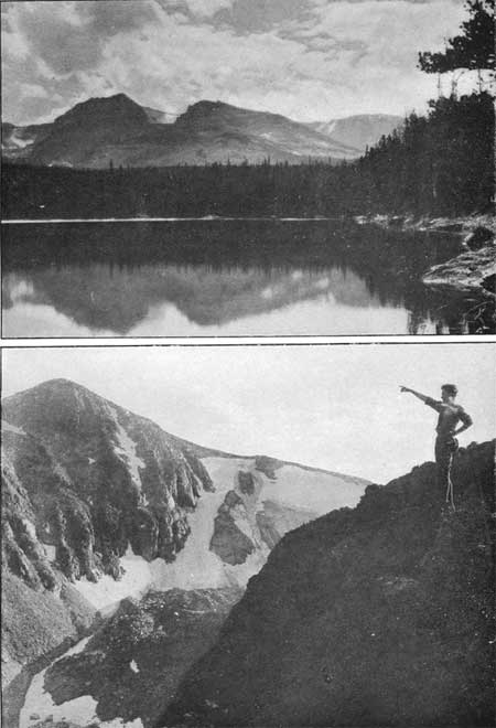
PLATE XVI.
FLATTOP MOUNTAIN AND HALLETT PEAK FROM BIERSTADT LAKE. Photograph by Clark Blickensderfer. HALLETT PEAK FROM FLATTOP MOUNTAIN. SHOWING TYNDALL GORGE. Photograph by National Park Service. |
FLATTOP MOUNTAIN (12,300 FEET), HALLETT PEAK (12,725 FEET), AND TAYLOR PEAK. (13,150 FEET).
[Report furnished by Arnold Emch (August, 1916).]
One of the best routes by which to climb these peaks is that from Bear Lake, or from the ranger station, over the trail to Flattop Mountain. From Bear Lake the summit of Flattop Mountain may be reached in about three hours. The same time is required for the climb from Fern Lake to Flattop Mountain. The trail from Fern Lake to Odessa Lake and Helene Lake, and from here to Flattop Mountain, leads through some of the finest scenery in the Rocky Mountain National Park. The upper portion of the crest north of Tyndall Glacier, not far from the trail, offers a magnificent view of Longs Peak. After leaving the trail to Grand Lake, and going around the upper edge of Tyndall Glacier, Hallett Peak which is always in full view may be climbed in an hour. If the starting point is The Loch climb to the Continental Divide above Andrews Glacier, and from there, following the Continental Divide, Hallett Peak may be reached in about one and a half hours.
To get an idea of the time required to cover various distances in this region data of an attempt on Lake Nanita will be given, which Clifford S. Higby and the author undertook in August 1916. Left Fern Lake Lodge 7.30 a. m.; Helene Lake, 9; Flattop Mountain, at head of Tyndall Gorge, 10.30; Hallett Peak, 11.15; and reached a point on the north ridge of Taylor Peak, 1.30 p. m. Our plan was to make Lake Nanita from here as nearly as possible along a direct line. Descending the western slope of Taylor Peak in a southwesterly direction we reached the sheer precipice directly opposite Lake Nanita at about 2.30 p. m. We tried in three different places to force a descent of the wall, but it proved absolutely impossible. Meanwhile heavy masses of fog began to envelop the surrounding rocks and crags, so that we decided to give up the attempt to go down to the North Inlet from this side. At 3.30 p. m. we started on our return trip. The fog was so dense that it was impossible to correctly locate directions.
We tried to retrace our route, and after climbing constantly for a seemingly unreasonable length of time we suddenly discovered by reaching a cairn that we were on the top of some peak. We had lost all sense of direction, and decided that it would be best to wait until there should be a break in the fog to get an orientation by studying the geography of neighboring peaks. Fortunately the masses of fog cleared enough for a moment so that we were able to recognize Hallett Peak in the distance and to make out that we were on top of Taylor Peak. This was at 5.25 p. m. The fog turned into snow and rain, and it was not long before our clothes stiffened with frost. We reached Flattop Mountain at 6.55 and Bear Lake at 9 p. m. We found pleasant night quarters in this comfortable camp. It rained all night and the next day. After a long wet tramp we returned to the village in the afternoon.
Dense fog on the heights comes quickly and sometimes makes it difficult to keep one's bearings. Carry a compass and keep constant watch of your location and the character of the surrounding country. Extra food and clothing should he kept at camp for emergency use or in case of prolonged bad weather.
|
|
PLATE XVII. LONGS PEAK FROM HALLETT PEAK. Photograph by G. H. Harvey, jr. GLACIER GORGE FROM LAKE MILLS. Photograph by Wiswall Brothers. |
OTIS PEAK (12,478 FEET).
[Report furnished by Reed A. Higby (July 15, 1916).]
Our party of 10 men and 3 women left Sprague's Hotel, followed the Loch Vale trail to its end, at The Loch and then went without a trail until we reached Bear Lake on the return trip. Our course was around the north side of The Loch, up the glacial basin to Glacier Lake; around its north shore and onto Andrews Glacier. Perhaps one-fifth of the way from The Loch to Glacier Lake was made on snow. The pull up the glacier was great sport, although a little strenuous and long for some who were wishing for lunch. It took us 30 minutes to climb and cross the glacier. We then went to the top of Otis Peak.
The descent from Otis Peak to Otis Gorge is thrilling. After skirting the north shore of Lake Haiyaha we cut across to Bear Lake, passing Grant Lake en route. Bear Lake Lodge gave us a glad welcome and a good send off to Sprague's Hotel, where we took the automobiles for Estes Park.
All who took the trip felt that it was one of great interest and beauty, varied in scenery and attractive because it was a circle trip and only 2 miles of trail were retraced on the return. A log of the trip follows:
| Place. | Time. | Elevation. | Scaled distance from preceding point. |
| a. m. | Feet. | Miles. | |
| Sprague's Hotel | 8 15 8 25 |
8,700 | |
| Miner's Cabin The Loch | 9 05 10 20 10 35 |
9,000 10,250 | 1.75 2.75 |
| p. m. | |||
| Glacier Lake | 12 10 12 15 |
11,350 | 2 |
| Top of glacier and Continental Divide | 12 50 1 10 |
12,000 | 1 |
| Otis Peak | 1 50 2 10 |
12,478 | .50 |
| Lake Haiyaha | 4 00 4 15 |
10,375 | 2.50 |
| Bear Lake | 5 45 6 05 |
9,550 | 2 |
| Sprague's Hotel | 6 55 7 00 |
8,700 | 2.50 |
| Estes Park (by auto) | 7 50 | 7,500 | 15 |
The walking portion of the trip, that is, from the time we left Sprague's Hotel until we returned, was 10 hours and 40 minutes.
OTIS PEAK FROM THE LOCH.
[Report furnished by Arnold Emch.]
This peak can he reached from The Loch by climbing to the Continental Divide above Andrews Glacier. From this point the top is easily reached in about half an hour.
There are different possibilities for interesting descents from this peak. One can follow the Continental Divide around Hallett Peak to Flattop Mountain, and from here take the trail to Bear Lake or the Government trail to the ranger station; or one can go down to Otis Gorge. For wildness and romantic scenery this gorge offers rare attractions. The descent from the peak to this gorge is made over the northern face, first over patches of snow which can be seen from the village, then through rock gulleys and slides down to Lake Haiyaha. The bottom of the valley in the vicinity of this lake is filled with an indescribable mass of huge bowlders. It takes about an hour from the top of Otis Peak to reach this lake. From here one can either follow Otis Gorge down to Glacier Creek, or cross the sharp-edged rock field, and the lower end of the ridge coming down, east from Hallett Peak, in order to reach Bear Lake. The trip from Lake Haiyaha to Bear Lake takes an hour and a half and is rather tedious on account of the network of fallen timber.
TAYLOR PEAK (13,150 FEET); AND M'HENRYS PEAK (13,300 FEET).
[Report furnished by Arnold Emch.]
From the heights north of Estes Park village, McHenrys Peak is easily recognized as the prominent peak 2-1/2 miles northwest of Longs Peak. The ridge to the left, connecting McHenrys Peak with Chiefs Head, is jagged and abrupt. Taylor Peak is to the right or 1-1/2 miles northwest of McHenrys Peak. A good way to climb these peaks is to take the Bartholf Park road, and then follow the Government trail along Glacier Creek to The Loch in the lower portion of Loch Yale. Here the shore is followed on the north side of the lake. The southern slope of Otis Peak is then traversed up to timberline until Andrews Glacier is reached. To get to the glacier one can go either to the left or right, immediately below it. On the right side one must climb a steep snow field, leading up to a rock ridge. Use care to avoid slipping on this field. On can pass around on the north side of the lake at the foot of the glacier. Some distance above the lake, the ridge that runs along the axis of the glacier, like a hogback, is reached and followed up to the saddle between Otis and Taylor Peaks.
Starting from the village, Sprague's Hotel in Bartholf Park is reached in an hour by automobile. From here one must allow from two to two and one-half hours to the saddle. From this point Taylor Peak is in full view, and may be climbed over the easy northern slope in one to one and one-half hours. Energetic climbers may reach both Taylor Peak and McHenrys Peak in one day. If one does not intend to climb Taylor Peak at the same time, the northern slope of Taylor should be climbed to about an altitude of 12,800 feet, that of the saddle between Taylor Peak and McHenrys Peak. Keeping at this altitude, the western and then the southern slope of Taylor Peak is followed to the head of Taylor Glacier. From this point McHenrys Peak can then be climbed over its northwestern ridge. The time consumed to climb from the head or top of Andrews Glacier to McHenrys Peak can be estimated at about three hours. This means that climbers who intend to return the same day should make a very early start from The Loch. Another way to the peak is up the whole length of the Loch Vale and over Taylor Glacier. This, however, makes greater demands on the climber.
| <<< Previous | <<< Contents>>> | Next >>> |
romo/toll/part2a.htm
Last Updated: 5-Jan-2007