|
Raising the Roof of the Rockies
A Geologic History of the Mountains and of the Ice Age in Rocky Mountain National Park |
Erosion Gains Control
Throughout the uplift and volcanism, the region of Rocky Mountain National Park was being eroded. The erosion continued until about 40 million years ago, by which time the mountains had been reduced to low hills. Summits where the Continental Divide is now were probably only a few hundred feet above adjacent valleys. The hilly terrain blended eastward into a gently rolling plain on which some major streams established courses in nearly the same positions as those they occupy today.
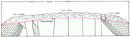
Though no deposits of this long interval of erosion have been found in the Front Range, weathering—that continuous breaking up and decay of rocks to produce soil—was extra ordinarily deep on the ancient plain. Even now, more than 40 feet of reddish weathered rock is preserved on it in places. The weathered rock falls apart easily, though many of the mineral grains are little decayed chemically. In the lower part of the decayed zone, the weathering process worked its way down into the blocky network of fractures in the underlying rock. As the sides of the blocks disintegrated, their unweathered cores remained as round masses of fresh rock surrounded by weathered debris. Later, when erosion stripped away this debris, the round cores were left behind as giant boulders which either remained in their original position or tumbled down the slope. Such boulders, easily mistaken for glacial boulders, are widespread on the knobs and mountains north of Estes Park, and the crest of Lumpy Ridge may be a remnant of the ancient plain. As we shall see, parts of the plain north and northeast of the Park were later covered by younger deposits for long intervals of time, and then exhumed as the covering rocks were stripped away by erosion. This accounts for the survival of the plain in places. Whether or not the gently sloping tundra uplands on Trail Ridge and along the Continental Divide are remnants of this plain has long been debated by geologists, but the available evidence indicates that they are of much younger origin.
|
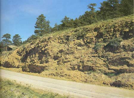
| Reddish, deeply weathered granite along road up Deer Ridge, about one mile north of Beaver Meadows entrance. (Fig. 6) (Wayne B Alcorn) |
|
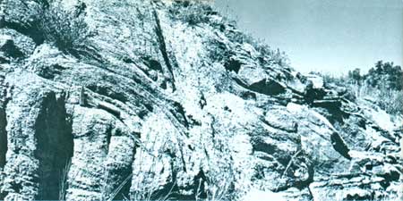
| Rounded core of weathered granite along Colorado Highway 66, one-quarter mile southwest of Estes Park. (Fig. 7). (Wayne B Alcorn) |
No stream deposits of this long erosion interval have been found in the Front Range, but fossil leaves and tree pollen preserved in deposits of silt and volcanic ash of this age in south-central Colorado and in Wyoming show that the forest changed progressively from its earlier subtropical character to an open savannah with groves of palm trees about 49 million years ago. Subsequently, it changed to a warm humid forest of broad-leaved evergreens and subequatorial hardwoods; then to a dry tropical forest of mixed hardwoods; and finally to a hardwood forest with open grassland parks, and brush and pine at higher elevations. These changes show that the climate became increasingly drier.
The Mountains Rise Again
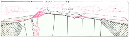
About 40 million years ago, forces within the earth again uplifted the northern part of the Front Range, including the Park. In central Colorado, to the south, the uplift was probably only a few hundred feet. Following it, the region west of Pikes Peak was at an altitude of only about 3,000 feet. In Wyoming, to the north, the uplift was over 1,500 feet in places and the mountains were probably at altitudes of 5,000-6,000 feet. As the mountains rose, the surface of the former widespread plain was tilted upward so that it sloped away from them more steeply.

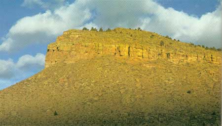
Erosion accompanied the uplift, cutting valleys in the old rocks of the mountains. On their flanks it etched away the soft sedimentary rocks from between the harder sandstone layers which remained behind as "hogback" ridges at the base of the mountains. These can be seen along the highway east of the Park at Lyons, at the mouth of Big Thompson Canyon west of Loveland, and along the highways north and west of Fort Collins. Erosion was greatest along major streams. In the Park, the ancestral Colorado River eroded a canyon at least 1,000 feet deep at La Poudre Pass, and another ancient stream, possibly tributary to the ancestral Colorado, cut a canyon 1,000 feet deep at Milner Pass.
In places, especially in Wyoming, mountains were uplifted across the path of major streams, but so slowly that the streams were able to cut their channels down as fast as the land rose. Thus, little by little they entrenched themselves in canyons across the mountains. Some of these canyons were nearly 1,500 feet deep. To the south, in central Colorado, major streams eroded valleys only about 200 feet deep at this time.
|
| Hogback ridge west of Lyons. Layers of former sand dunes changed to rock have been tilted upward by the rising mountains and eroded by streams to form the ridge. (Fig. 8) (Dwight L. Hamilton) |
Neck Deep in Volcanic Ash
From about 37 million years ago to about 34 million years ago, volcanic ash, borne by the winds from volcanoes to the southwest and west, engulfed the basins on both sides of the northern Front Range and filled the canyons in its flanks. Although the mountains in the Park, still about 6,000 feet above sea level, probably were not covered, the somewhat lower mountains north and northwest of the Park were nearly buried. Patches of the ash remain today on some summit areas in the Medicine Bow and Laramie Ranges in Wyoming.
At about the same time, volcanoes broke out west of Canyon City in the southern part of the Front Range. Lava and hot volcanic ash flows spread out from them across the deeply weathered surface of the former widespread plain. Remnants of the lava on the weathered surface of the plain still can be seen in Devils Hole along the Arkansas River.
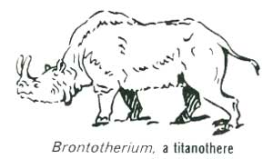
The climate of this interval was warm-temperate to subtropical, as indicated by the presence of leaves and pollen of many broad-leafed trees and sequoia in lake deposits of this age at Florissant, west of Colorado Springs. Ponderous titanotheres and rhinoceroses roamed both mountains and plains, as well as many small rodents such as rabbits, beavers, opposums, cat-like and dog-like carnivores, and dog-sized three-toed horses. The particular species are now extinct.
| <<< Previous | <<< Contents >>> | Next >>> |
richmond/sec4.htm
Last Updated: 8-May-2007