|
Gateways to Commerce: The U.S. Army Corps of Engineers' 9-Foot Channel Project on the Upper Mississippi River |

|
INTRODUCTION
The Mississippi is well worth reading about. It is not a commonplace river, but on the contrary is in all ways remarkable. [1]
Mark Twain
Huckleberry Finn learned about the Mississippi River on a raft. Today, young boys are more likely to learn how to navigate the Upper Mississippi River from a computer program at a U.S. Army Corps of Engineers Visitor Center. Does our modern Huck Finn want to go from Hannibal to St. Louis? First, he must get past the dam at Saverton, Missouri. As he pushes a button, Huck watches the video screen as his computer-generated towboat passes through the upriver gates of a navigation lock. He pushes another button. The gates close and the water level in the lock drops several feet, until it is the same as the downriver side of the dam. Huck pushes yet another button. The downriver gates open, and the towboat cruises on down the Mississippi. But the trip is not over. Before he reaches St. Louis, Huck will also have to "lock through" at Clarksville, Winfield, Alton, and Granite City. Like its real-life counterparts, Huck's little towboat will have to repeat this process four more times.
|
| The 9-Foot Channel Project created a fully navigable canal from Minneapolis/St. Paul to St. Louis and linked the Upper Midwest with New Orleans, a port offering access to Central and South American markets. Below St. Louis, the Mississippi River is navigable in its natural state. (Drawing: Catherine Colby, National Park Service) (click on image for a PDF version) |
Once, the Upper Mississippi River flowed freely. From its headwaters in upper Minnesota, there were no locks and dams to obstruct the river's path as it flowed through the forests and fields of the Upper Midwest. But the river was also temperamental. Compared to the Lower Mississippi, that stretch of the river below St. Louis made mighty by the combined waters of the Missouri and the Ohio Rivers, the Upper Mississippi River was unreliable. During times of flood, the Upper Mississippi was deep-flowing, but turbulent. More frequently, long dry spells made the river too shallow to navigate. The river's uncharted shoals and sand bars presented a constant danger. Equally dangerous were the "snags," trees that storms had washed from the river's banks into its waters. The Upper Mississippi was a challenge to all who plied its waters. And the travelers were many: Native Americans in birch bark canoes, French traders in pirogues, Army explorers in keelboats, lumbermen on log rafts, and enterprising steamboat captains who cautiously steered their paddlewheelers through the river's rapids. Whatever the craft, its success depended upon the river's ever-changing conditions, and the skill of its pilot.

|
| Reflecting pride in engineering, the Corps of Engineers has built Visitor Centers at 9-Foot Channel Project sites. The displays highlight the history of the Corps, and the operations of the 9-Foot Channel. Lock and Dam No. 15. (Peter A. Rathbun) |
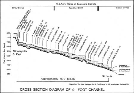
The Upper Mississippi River 9-Foot Channel Project, which was designed and constructed by the U.S. Army Corps of Engineers between 1930 and 1940, has transformed the once free-flowing river into a slack-water navigation system. The system is often compared to a stairway. The "treads" are the slack-water lakes, or navigation pools, created by a series of dams across the river. The "risers" are the locks which, through their changing water levels, carry the boats from one pool to the next. From the largest barge to the smallest raft, every vessel traveling the Upper Mississippi River has to navigate this system of locks and dams. While passage through the locks is time-consuming, it provides what the river in its natural state could not: a dependable 9-foot navigational depth on the Upper Mississippi.
|
| In section, the Upper Mississippi River 9-Foot Channel resembles a water "stairway." Each lock and dam is situated higher than the one below it. Instead of the river channel becoming more shallow as one moves upriver, a 9-foot depth is regularly maintained from lock to lock, enabling fully-loaded, commercial barges and tows to use the river without having to transfer cargo to smaller and smaller barges as they proceed upriver. (Drawing: Catherine Colby, National Park Service) (click on image for a PDF version) |
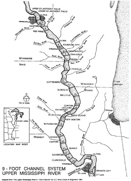
As originally planned in the 1920s, the 9-Foot Channel Project was comprised of 26 locks and dams and their associated pools that extended from St. Paul, Minnesota, south to Alton, Illinois. In 1937, Congress authorized a 4.6 mile extension of the original project at its upstream end, and two additional complexes were built: the Upper St. Anthony Falls Lock and Dam, and the Lower St. Anthony Falls Lock and Dam. In 1953, the system was again expanded by the construction of Lock No. 27 and the Chain of Rocks Canal, which extended the channel to St. Louis. Dam No. 27, also known as the Chain of Rocks Dam, was finished in 1964. As now completed, the 9-foot channel on the Upper Mississippi is made up of 29 lock and dam complexes. The system extends across a 669-mile stretch of river which, between Minneapolis and St. Louis, has a fall of approximately 400 feet.
The Upper Mississippi River 9-Foot Channel Project was one of the largest and most ambitious river improvement projects ever constructed in the United States. From conception to completion, the massive undertaking reflected the changing political moods of the nation, spanning several presidential administrations and agendas. The project originated in the 1920s when it was promoted as a way to alleviate the Nation's worsening farm crisis. It was also aimed at allaying the inequities in commercial rail and water freight rates brought about by the 1914 opening of the Panama Canal. Although direct governmental aid was an anathema to the conservative Warren Harding and Calvin Coolidge administrations, waterway improvements were an acceptable way to promote the general good. The 9-Foot Channel Project was authorized by the Rivers and Harbors Act of 1930 during the presidency of Herbert Hoover, an engineer and strong waterway improvements advocate. During the Great Depression, the project was recast into a massive public employment project by the New Deal administration of President Franklin Roosevelt. As a result, much of the 9-Foot Channel Project was constructed during what might be called the U.S. Army Corps of Engineers' "Golden Age," the period of its greatest dam construction, organizational security, highest volume of work, largest area of responsibility, and maximum power.
By the 1940s, the Corps of Engineers had successfully converted the once free-flowing river into a series of interconnected pools that ensured enough water for fully loaded modern boats and barges. The completion of the 9-Foot Channel Project turned the upper reaches of one of the world's largest rivers into an intra-continental channel, settling the question of a fully navigable, north-south, interior river system through the Midwest. The project brought economic benefits and recreational opportunities to the entire region. It also served as an impetus for the upgrading of municipal drinking water and sewage disposal systems in towns and cities located along the river.
But the project was not without controversy. Railroads, claiming damage to their right-of-ways, contested it in the courts. Conservationists feared its effects on the Upper Mississippi Valley environment. Indeed, the question of the lock and dam system's impact on the environment remains controversial even today. Ultimately, however, the economic benefits overrode all other concerns. From the beginning, the goal of increased commercial river transportation transcended all other considerations. After the project was completed, river traffic on the Upper Mississippi increased from 2,400,000 tons in 1939, to 68,400,000 in 1976. Business and politics had been well served. [2]
Now at least 50 years old, the locks and dams of the Upper Mississippi River 9-Foot Channel Project are showing their age. In their day, however, they represented technological breakthroughs in navigation engineering. The locks and dams that comprise the project constitute seminal developments in the technological history of American river navigation. With the 9-Foot Channel Project, the Corps of Engineers inaugurated a new era in slack-water navigation in the U.S.: the adoption of non-navigable dams that incorporated both roller and Tainter gates. Ironically, the Upper Mississippi River 9-Foot Channel Project also resulted in the obsolescence, by the project's end, of combination roller and Tainter gate dams. Technological advances resulting from the research and development incidental to the design and construction of the project's lock and dam systems enabled the U.S. Army Corps of Engineers to develop both submersible and non-submersible Tainter gates that nearly matched the capabilities of the roller gates, and which were less expensive and more easily operated. The Corps' creation of a new dam type, and its subsequent obsolescence during the course of a single project, dramatically illuminate the evolutionary nature of American engineering. Dam gates that were state-of-the-art at the beginning of the 9-Foot Channel Project were passe' before the project's end.
INTRODUCTION NOTES
1. Mark Twain (Samuel Clemens), Life on the Mississippi, first American edition (1883), as printed in Mark Twain, Mississippi Writings (New York: Library Classics of the United States, Inc., 1982), 227.
2. Raymond H. Merritt, The Development of the Lock and Dam System on the Upper Mississippi River (Washington D.C. National Waterways Roundtable: U.S. Army Water Resources Support Center, n.d.) 96; and Colonel Philip B. Fleming, interview by Mary Proal Lindeke of WMIN Radio Station, "Talking Things Over," January 12, 1939, 11:45 a.m., radio script, 7.
| <<< Previous | <<< Contents>>> | Next >>> |
rmr/2/intro.htm
Last Updated: 01-Feb-2008