|
NATIONAL PARK SERVICE
Pacific Coast Recreation Area Survey |

|
UNDEVELOPED SEASHORE AREAS IN CALIFORNIA (Northern Portion)
|
| California — Northern Portion (Vicinity Map) (click on image for an enlargement in a new window) |
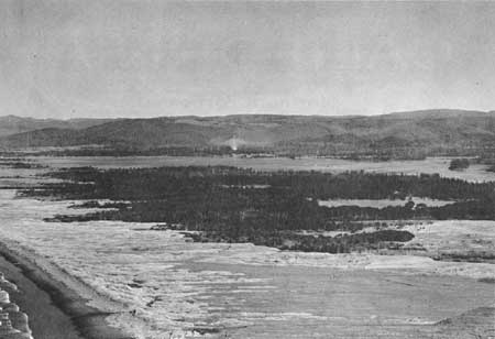
27
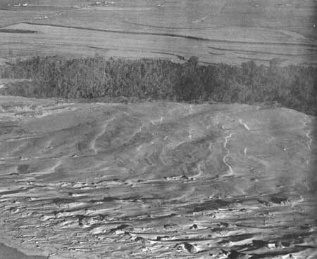
Pelican Bay Beach
Northern California
LOCATION: The southern end of the area is approximately three miles northwest of Crescent City.
ACCESSIBILITY: Limited access is available by automobile on graded roads from the north and the south, plus one spur road running directly to the beach immediately north of Lake Earl.
DESCRIPTION OF AREA: Pelican Bay Beach comprises ten miles of ocean beach, extending from Point St. George north to the Smith River. The area extends inland to include Lake Earl and Lake Talawa and adjacent lands. In general, the terrain is relatively flat with only slight changes in contour caused by low, stabilized or migrating sand dunes. The sandy beach is dark in color and has considerable sea debris deposited above hightide. There are wooded portions of pine and spruce adjacent to the two lakes. In some cases, the trees are within one-half mile of the ocean beach. Lake Earl is the larger of the two lakes and drains into Lake Talawa, which in turn empties into the ocean. These shallow but excellent recreation lakes also serve as resting habitat for migrating waterfowl, and large concentrations of ducks are found here in certain seasons.
PRESENT USE: The entire ocean frontage is undeveloped. The adjacent upland is used primarily for grazing. The north, west and south shorelines and land adjacent to Lake Earl are sparsely developed with private residences and commercial improvements.
ANALYSIS: This is an unusually long stretch of undeveloped beach, and the adjacent lakes possess fine recreation and biological values. The area is very desirable for public purposes, and as much land as possible should be acquired and preserved for future public needs.
|
| Pelican Bay Beach |
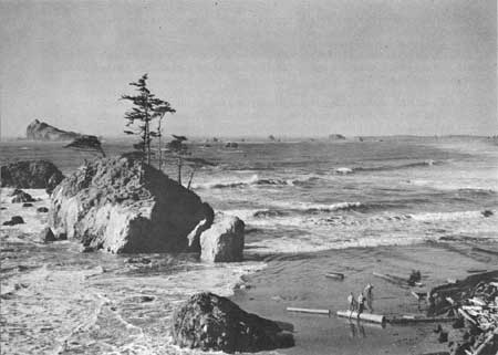
28
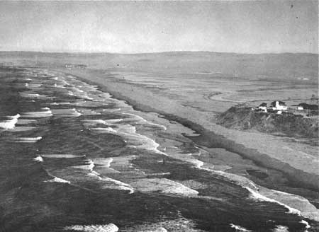
Pebble Beach
Northern California
LOCATION: Immediately northwest of Crescent City.
ACCESSIBILITY: By automobile via hard surfaced roads from Crescent City.
DESCRIPTION OF AREA: This area offers a combination of unusually scenic shoreline and adjacent recreation beach. The area extends from Hall Bluff north to the southern limit of Point St. George, and includes approximately two miles of ocean frontage. Potential overlooks within the area would provide opportunities for extensive views of the scenic coastline with its many offshore rocks and rugged headland. Not only is this rocky shoreline noted for its scenic qualities, but also for the interesting and scientifically valuable invertebrate life within its tidal areas. Offshore, Castle Rock (233 feet high) is frequently visited by colonies of sea lions and flocks of geese. The northern portion of the shoreline has a sandy beach, but at present it is covered with sea debris above the high tide line.
PRESENT USE: The entire shoreline is undeveloped, although it is paralleled by a road a short distance inland. Private residences have been developed adjacent to the road along the southern portion of the area, but none exist on the oceanside.
ANALYSIS: The excellent scenic, scientific, and recreation features of this area are in close proximity to a center of population. It should be given a high priority for acquisition for public purposes. A portion of this area is on the Five Year Master Plan of the Division of Beaches and Parks.
|
| Pebble Beach |
29
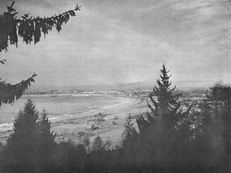
Shell Beach
Northern California
LOCATION: One mile southeast of Crescent City.
ACCESSIBILITY: By automobile via U. S. Highway 101 and surfaced county roads.
DESCRIPTION OF AREA: This area is a curving, dark colored sandy beach that extends three and one-half miles south from a point near the existing breakwater at Whaler island. The immediate upland from the beach is relatively flat, with a few small marshes situated in slight depressions. The foreshore is gently sloping. Above high tide, portions of the beach are heavily covered with driftwood and other sea debris. The southern terminus of the area is a rocky vista point that rises more than 200 feet above the beach.
PRESENT USES: The majority of the area is used for ranching purposes. Also, seven private residences have been established within the area. Commercial development is limited to two motels along Highway 101.
ANALYSIS: Shell Beach is a potential public use area located in close proximity to a center of population. The area should be acquired when the public demand is sufficient to warrant its use for this purpose, but before expanding private developments make this impractical.
|
| Shell Beach |
30
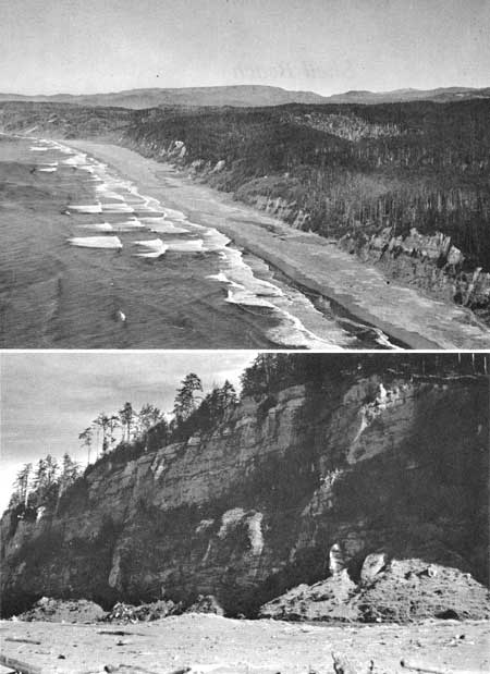
Gold Bluffs
Northern California
LOCATION: Three miles north of Orick and 40 miles south of Crescent City. The area is adjacent to the west boundary of Prairie Creek Redwoods State Park.
ACCESSIBILITY: The area is inaccessible except by jeep trail from Highway 101.
DESCRIPTION OF AREA: This unusually fine coastal area extends from Mussel Point north to the existing Prairie Creek Redwoods State Park ocean access, a distance of approximately eight and one-half miles. Inland it extends to the State Park or U. S. Highway 101 and varies in width from 1 to 2-3/4 miles. The entire length of the shoreline is a wide, relatively clean sandy beach. Immediately inland from the beach is a sandflat varying in width from 100 yards to 1/4 mile. Back of the sandflats and parallel to the beach are the nearly vertical "gold bluffs" which attain heights of 250 feet or more, and are partly covered with Sitka spruce. The area between the State Park and the bluffs is rugged in character, with steep-sided canyons and sharp ridges. It supports thick stands of Douglas fir, Sitka spruce, and coastal redwood. Alder is found in abundance at the mouths of several creeks. Fern Canyon, within the area, is of outstanding beauty, 30 feet deep and covered with a solid growth of five-fingered ferns. This is one of the few places where Roosevelt elk are found in close association with the seashore. Early day placer mining within the area presents historical value.
PRESENT USE: The entire area is undeveloped except for one or two cottages. Commercial timber is harvested in certain portions.
ANALYSIS: This undeveloped area possesses many excellent seashore values, and should be acquired for public ownership for its recreation and for conservation of the natural resources. The Division of Beaches and Parks is endeavoring to acquire the Fern Canyon portion at the present time.
|
| Gold Bluffs |
31
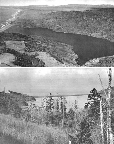
The Lagoons
Northern California
LOCATION: Six miles south of Orick and 30 miles north of Eureka.
ACCESSIBILITY: The Coast or Redwood Highway (U.S. 101) is adjacent to the area, and spur roads lead directly into the uplands near the lagoons.
DESCRIPTION OF AREA: This area is composed mainly of three lagoons and uplands adjacent to the ocean shoreline. The largest of the lagoons is Big Lagoon with 1,365 acres while Stone Lagoon is a 580-acre body of water. The smallest is Freshwater Lagoon, with 200 acres. They extend along the coast for over eight miles, and are separated from the ocean by barrier sandbars. These lagoons are basically bodies of salt water with periodic isolation from the sea when the barrier bars remain solid from ocean deposition. Freshwater Lagoon is the least brackish of the three. Native vegetation of coast redwood, salal, alder, wax myrtle and spruce grows on the uplands surrounding the lagoons. Biologically, the lagoons provide good resting habitats for a variety of waterfowl.
PRESENT USE: Of the 8 miles of ocean shoreline, 5 miles are owned by the State Division of Beaches and Parks. One mile is under the jurisdiction of the State Division of Highways, while the remaining two miles are privately owned. The existing State Park includes 926 acres. A relatively small portion of the lagoon frontage is included in that area.
ANALYSIS: The lagoons, their shorelines, and the upland and ocean frontage provide excellent opportunities for seashore and related aquatic recreation activities. To provide a complete unit, the remaining undeveloped portions should be acquired for public use. At the present time, the Division of Beaches and Parks anticipates acquiring the additional land in the area.
|
| The Lagoons |
32
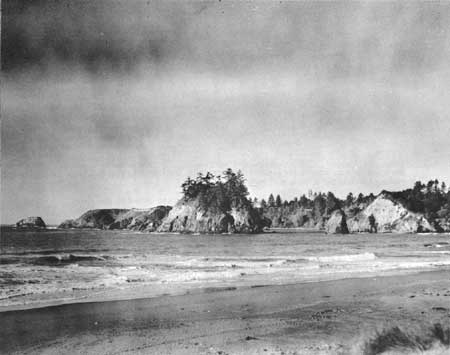
Elk Head
Northern California
LOCATION: Immediately north of Trinidad Head, and one-half mile northwest of the town of Trinidad.
ACCESSIBILITY: By hard surfaced county road from Trinidad and Highway 101.
DESCRIPTION OF AREA: The Elk Head area is an unusually scenic mile-long section of the northern California coastline. Included is a small cove that has a fine display of offshore rocks and islands, with such landmarks as Off Trinidad Rock and Pewetole island. A portion of the shoreline within the cove has an excellent sandy beach, with a 100-foot coastal bluff immediately upland. More than 50 percent of the level upland and bluff is covered with a dense growth of alder and Douglas fir, but Elk Head itself is barren or only partially covered with grass and other ground covers. Immediately south on the leeward side of Trinidad Head, is the site of a proposed small craft harbor, while to the north or the windward side, is Trinidad Beach State Park. This park forms the southern terminus of the area.
PRESENT USE: The area is sparsely populated. The Douglas fir is being logged on some portions and the grassland is being used for the grazing of livestock.
ANALYSIS: Although this area is relatively small in size, its unusually fine qualities more than compensate for this deficiency. The area should be acquired for future public use.
|
| Elk Head |
33
Mad River Beach and Slough Area
Northern California
LOCATION: Three miles west of Arcata.
ACCESSIBILITY: By paved roads from Arcata.
DESCRIPTION OF AREA: This is a seven and one-half mile section of ocean beach in association with sand dunes, trees and other vegetation. It extends from Samoa, which is on the North Spit of Humboldt Bay, north to the Mad River. Inland, the area terminates at the Mad River Slough and Humboldt Bay. The immediate shoreline is a wide, gently sloping sandy recreation beach that is relatively free of logs and other sea debris. East of the beach, and extending the entire length of the area, are scenic sand dunes. Inland from the dunes to the bay and slough lies a vegetative strip of coastal shore pine (lodgepole) forest. The transition from ocean through beach, dunes, and coastal forest to tidal marsh is an excellent example of ecologic succession. This mudflat-tidal marsh is one of the most nearly optimum shorebird habitats to be found along the entire Pacific Coast.
PRESENT USE: The towns of Samoa and Manila are adjacent to the area at the southern terminus, and private residences are sparsely scattered throughout the northern portion.
ANALYSIS: The scenic qualities, recreation potentialities and important biological values, all in close proximity to centers of population, make this area most desirable for public ownership and use.
|
| Mad River Beach and Slough Area |
34
Humboldt Bay-South Spit
Northern California
LOCATION: Four miles southwest of Eureka, across Humboldt Bay.
ACCESSIBILITY: By car on paved road from U. S. Highway 101.
DESCRIPTION OF AREA: The area includes the narrow four and one-half mile long sandspit with its adjacent mudflats, salt marshes, and sloughs. Pasture grass, saltgrass, and bullrush supplement extensive eelgrass beds in the bays and provide food for vast populations of waterfowl, shorebirds, and marine birds. The sandspit supports a sparse vegetative cover and is cluttered with considerable sea debris.
PRESENT USE: The tidal portion of the area shows no evidence of use by man other than a number of duck blinds adjacent to the sandspit. The low pasture land at the southeastern end of the bay is presently being grazed by dairy cattle. The sandspit receives the heaviest use in the form of picnicking, clamming, surf fishing, and waterfowl hunting. The aquatic portion is the wintering ground for one of the largest concentrations of black brant geese on the Pacific Coast.
ANALYSIS: The area possesses the necessary attributes which qualify it as a waterfowl refuge. Humboldt Bay is listed by the U.S. Bureau of Sport Fisheries and Wildlife on its list of proposed acquisitions in connection with the Pacific Flyway. The South Bay appears to be the most undisturbed and best suited for refuge status.
|
| Humboldt Bay Southspit |
| <<< Previous | <<< Contents>>> | Next >>> |
rec_area_survey/pacific/ca1.htm
Last Updated: 25-Jun-2007