


Survey of Historic Sites and Buildings
 |
CERRILLOS MINING DISTRICT New Mexico |
|
| ||
This district, located in the Cerrillos Hills, Ortiz Mountains, and the northern foothills of the San Pedro Mountains, throughout the centuries has yielded modest quantities of gold, silver, coal, turquoise, and other minerals. It has been worked since prehistoric times, when the Pueblo Indians obtained turquoise. During the Spanish period, the Indians labored at the turquoise mines under the supervision of priests, but during the Pueblo Revolt (1680-92) they caved in the shafts and camouflaged the entrances.
In later times, activities in the district were concentrated in two distinct locations: the Old Placer Area, to the east of the Ortiz Mountains, around the towns of Dolores and Galisteo; and the New Placer Area, west of the mountains, around Golden. In 1828 a Mexican herder discovered gold placers near present Dolores. In 1832 the source of the placers, a gold-bearing quartz vein, was found on a land grant of José Francisco Ort´z. Ortíz founded the Ortiz Mine and went into partnership with a skilled miner, Don Demasio López. The mine yielded $60,000 to $80,000 annually for some time, but Ortíz separated from Lopez and could not make it pay himself. In 1864 he sold it to the New Mexico Mining Company, which erected stamp mills, utilized coal from the mines near the town of Madrid, and conducted profitable operations for several years. Finally the mine closed because of poor management.
In the New Placer Area a rush followed gold discoveries in 1839. A mining camp, Tuerto, grew up and by 1845 was the center of the area. Once the deposits were depleted, it became a ghost town and nothing remains of it today. In 1879 the discovery of sulphide, zinc, lead, and silver fostered the growth of Bonanza City and Carbonateville. A decade later Golden supplanted these two towns after a gold strike there.
Many remains of mining days have survived in the Cerrillos District. Rock foundations mark the sites of Carbonateville and Bonanza, which are surrounded by abandoned mineworks. Golden is a ghost town, but behind the small village of Dolores stands the abandoned works of the Ortíz Mine.
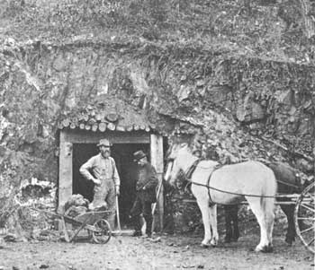 |
| Grant Tunnel in the Cerrillos Mountains of New Mexico Territory. Eager miners dug thousands of such tunnels all over the West. From a Henry Brown stereopticon. Courtesy, Museum of New Mexico. |
|
CHISUM RANCH New Mexico |
|
| ||
This ranch on the Bosque Grande was founded by John Chisum, one of the great cattlemen. A Tennessean, Chisum emigrated to Paris, Tex., where he first worked as a county clerk. After the Civil War he drove three small herds of cattle to Little Rock and sold them to a packinghouse in which he held an interest. Facing bankruptcy when the packinghouse failed, he started a new drive up the Pecos River over the Goodnight-Loving Trail. Establishing his headquarters in the Pecos Valley at South Spring, he sold his first herd of 600 cattle at Fort Sumner and obtained a contract to deliver 10,000 more. Recognizing the riches of the Pecos Valley, he established a permanent ranch around his headquarters site, though he maintained cow camps at two other locations. Between 1870 and 1881 he had one of the largest cattle holdings in the world. His ranch extended from Fort Sumner on the Pecos 200 miles southward to the Texas line and at its peak ran more than 80,000 head of cattle. A prominent figure in Lincoln County, Chisum was involved in the Lincoln County War. Indian raids, rustlers, and competition from other ranchers finally diminished his power and wealth.
After Chisum died in 1884, J. J. Hagerman and a group of businessmen bought the ranch. In 1904 Hagerman remodeled the ranchhouse but left the main structure intact. Later he sold the ranch to Cornell University as an experiment station for range control and crop diversification. Today the ranch is operated as South Spring Dairy Ranch. No remains of the original ranch buildings have survived.
|
CIMARRON New Mexico |
|
| ||
Cimarron, still a cattle center today, has a colorful history. It was founded by Lucien B. Maxwell, owner of the 1,714,765-acre Maxwell Grant. A hunter and trapper from Kaskaskia, Ill., Maxwell was the son-in-law of Carlos Beaubien, who in 1841 with Guadalupe Miranda obtained from the Mexican Government a tract of land in present northeastern New Mexico that extended into south-central Colorado and whose ownership was to be litigated for many decades after the United States acquired the region from Mexico, in 1848.
In 1849 Maxwell settled on the tract, and the town of Cimarron grew up around his headquarters. In 1864, after buying out the remaining heirs on Beaubien's death, Maxwell built an adobe mansion and filled it with expensive furniture. Employing 500 peons and cultivating thousands of acres, he grazed vast herds of cattle and sheep, many of which he sold to Army posts. Often he started a rancher out by giving him a herd of cattle, sheep, or horses and a small ranch to run on shares. Then the shareholder reciprocated by supplying surplus stock, hay, or grain to fill Government contracts. The discovery of gold on his land in 1867 ruined Maxwell, for he invested a fortune in the mining venture and it failed. In 1870 he sold his grant and moved to Santa Fe.
During Maxwell's ascendancy Cimarron was a lively and raucous cowtown. It was the agency for the Ute Indians; the cowboy capital of northern New Mexico; and an outfitting point for prospectors, trappers, and hunters bound for the mountains. "Buffalo Bill" Cody, who jointly owned a sheep ranch with Maxwell near Cimarron, organized his famous Wild West Show at the town.
Cimarron today has a historic atmosphere. The Don Diego Tavern, built in the 1870's and reputedly the scene of 26 killings, still stands and serves as a hotel. The warehouse for the Ute Agency, constructed in 1848, now houses a grocery store. The county courthouse, erected in 1854, is deserted.
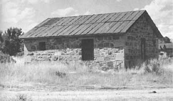 |
| Stone jail at Cimarron, New Mexico, built in 1874. Still a cattle center, Cimarron was once a lively cowtown. |
|
ELIZABETHTOWN New Mexico |
|
| ||
This town was the gold-mining center of the Sangre de Cristo Mountains. In 1866 prospectors discovered gold in the streams draining Baldy Mountain, and a small rush got underway. Two years later John Moore and T. G. Rowe laid out Elizabethtown, or E-Town for short. In 1870 the town had 7,000 inhabitants, but in the middle of the decade the placers began to give out and Indians in the vicinity became increasingly troublesome. Not until 1901 did the settlement again prosper. That year the Oro Dredging Company built an enormous dredge, which had a capacity of 4,000 cubic yards a day, and began profitable operations. The dredge operated for 4 years. Today Elizabethtown is a ghost town. A few people live in the decaying hulks of old buildings, and nearby are abandoned mineworks.
|
HILLSBORO New Mexico |
|
| ||
In 1877 two prospectors discovered gold on the east side of the Black Range and soon opened the Opportunity and Ready Pay Mines. As other miners arrived in the area, a camp formed that was first known as Hillsborough and later Hillsboro. Despite its isolated location and vulnerability to Indian raids, all through the 1880's and 1890's it teemed with life. The mines produced more than $6 million in gold and silver. Although no mining is done in the vicinity today, the town has survived. It contains many old stone and adobe buildings that have been covered with other materials. Also of interest are the ruins of the large stone jail and the lower story of the old Sierra County Courthouse.
|
LC RANCH HEADQUARTERS New Mexico |
|
| ||
In its heyday the LC Ranch, controlling a million-acre range that carried 60,000 head, overshadowed all others in southwestern New Mexico. In the late 1870's Tom Lyons, an Englishman who was reared in Wisconsin, came to New Mexico and formed a mining partnership with Angus Campbell, a Silver City prospector. In 1880 the partners sold their mining interests and bought the Nogales, or White House, Ranch, located 10 miles north of Gila. Immediately they began to monopolize the water rights in the vicinity and eventually claimed all the range from the mouth of Duck Creek to above Mule Springs. In 1890 they moved the ranch headquarters into the town of Gila, where Lyons constructed a 25-room ranchhouse. Campbell, concentrating on irrigated farming on Duck Creek, directed the building of dams and reservoirs, while Lyons specialized in the cattle business. In 1885 he formed the Lyons and Campbell Ranch and Cattle Company, capitalized at $1,500,000, under the laws of the State of New Jersey. When Lyons died in 1917, the firm lost its driving force and was sold piece by piece until only the 5-acre headquarters complex remained. This property is owned today by Arthur L. Ocheltree, who is restoring the ranchhouse to its former grandeur.
|
PINOS ALTOS New Mexico |
|
| ||
Col. Jacob Snively and a party of forty-niners, who had drifted back from California, discovered gold in 1860 near the site of this town. Despite Apache hostility in the vicinity, 1,500 miners arrived within 6 months and founded Pinos Altos. A series of raids culminated in a bloody battle in 1861, when Mangas Coloradas led 500 Indians against the town. Most of the miners fled, but Virgil Mastin remained and in 1866 formed the Pinos Altos Mining Company. By 1902 the mines in the vicinity, then controlled by Hearst interests, had produced $4,700,000 worth of gold. Large-scale operations subsequently shifted to the Silver City vicinity. Many abandoned mineworks are in the area of the town today, and some small-scale mining is done.
|
SANTA RITA COPPER MINE New Mexico |
|
| ||
This is the oldest active mine in the Southwest and one of the first copper mines to be developed within the boundaries of the United States. According to tradition, in 1800 an Apache chief guided José Manuel Carrasco, commandant of a Spanish post in New Mexico, to the site. In 1804 Carrasco sold the property to Francisco Manuel Elguea, a wealthy merchant from Chihuahua, who obtained the Santa Rita del Cobre grant from the Crown to develop the mine. Using convict labor obtained through his influence with the Spanish Government, Elguea built a primitive smelting plant and an adobe fort for defense against Apache raids. For a time in the 1820's Sylvester Pattie, an American trapper, and some associates worked the mine under a lease from Elguea's widow. The mine then passed through many hands until the 1870's, when a group of Denver financiers purchased it. It is operated today by the Kennecott Copper Company. Several years ago the company removed the only surviving evidence of the Spanish period, an adobe fortress tower, to make way for new construction.
|
WHITE OAKS New Mexico |
|
| ||
Some cowboys found gold in the vicinity of Baxter Mountain as early as 1850, but a substantial strike was not made until 1879, when two prospectors began to work the North and South Homestake Mines. For the next three decades these mines, together with the existing Old Abe, poured forth a steady stream of rich ore. Laid out in 1880, White Oaks soon had churches, schools, hotels, newspapers, and a population of 4,000 people. During the 1880's it was one of the largest and most influential towns in the Territory. When the El Paso & Northeastern Railroad bypassed the town in 1899 in favor of Carrizozo, it began to die and today is almost deserted. Only a few brick and stone structures, including the bank and church, are still standing. The surrounding hills are marked with abandoned mine shafts and cluttered with mine wreckage.
 |
 |
http://www.cr.nps.gov/history/online_books/prospector-cowhand-sodbuster/sited9.htm
Last Updated: 22-May-2005