


Survey of Historic Sites and Buildings
 |
AURORA Nevada |
|
| ||
Founded in 1860, when three California prospectors found silver ore near the site, Aurora was one of the earliest mining camps in Nevada and marked the beginning of the eastward movement of the mining frontier from California into western Nevada. In 1863 it boasted a population of 6,000 and had 17 quartz mills, 20 stores, 12 hotels, and many boardinghouses and saloons. Mark Twain unsuccessfully tried his hand at mining in the vicinity. The mines began to play out in 1864, and disastrous fires in 1866 and 1873 further reduced the population of the town. By 1880 only 500 of the people remained, most of the others having moved to Bodie, Calif., about 12 miles to the southwest. After 1883 the town rapidly declined. During World War I the mines reopened briefly, but by 1930 only one inhabitant was living in the town. A few ruins of brick buildings and a school and a few abandoned framehouses may be seen today.
|
AUSTIN Nevada |
|
| ||
The rush of 10,000 miners to the site of Austin in 1863, following the discovery of silver by William Talcott, marked the advance of the mining frontier into central Nevada. From this base, where speculation was rife, important silver strikes were made subsequently at Eureka, Hamilton, and other places in southeastern Nevada. The town of Austin—366 brick, adobe, and frame buildings—became the county seat. In 1868 the mines in the area yielded a peak figure of $2,574,810. But thereafter production decreased, and most of the population moved to Eureka and Hamilton. When the Central Pacific Railroad passed 92 miles north of Austin, the city was no longer on the main artery of commerce and declined further. By 1900 it had only 600 inhabitants.
Today only a two-block-long cluster of 13 original brick buildings on Main Street recall the town's former glory. Included are three brick churches, the International Hotel, the two-story courthouse, several one-story stores, and the former newspaper office. Reuel C. Gridley's former store now serves as the Austin Historical Museum.
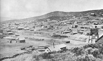 |
| Mining jumped to central and eastern Nevada in 1863, when prospectors discovered silver near the site of Austin, shown here in the 1870's. Courtesy, National Archives. |
|
BELMONT Nevada |
|
| ||
In 1865 an Indian discovered silver quartz veins at the site of Belmont. Miners rushed in, organized the Philadelphia Mining District, and founded the mining camp of Belmont. When the first of three stamp mills opened the following year, the camp already had a population of 1,500. Only a year later, it became the county seat. The mines in the vicinity reached peak operations in 1873-74 and then declined. They finally closed in 1885, and the population departed. In the early 1900's the county seat was moved to Tonopah. Today Belmont is a ghost town. Still standing is the unused two-story brick courthouse, erected in 1874, as well as a few stone residences and a number of rundown framehouses. On the north side of town are the ruined walls and stack of the Combination Mill Company smelter.
|
CARSON CITY UNITED STATES MINT Nevada |
|
| ||
This mint represented the recognition by the Federal Government of Nevada's importance on the mining frontier. In the 1860's the bullion output of the State was second only to that of California, and two decades later led the Nation. For the period 1861-80 it totaled more than $365,341,000. The Government established the mint at Carson City because the output of the Comstock Lode overtaxed the capacity of the San Francisco Mint. Construction of the building began in July 1866, and minting operations started little more than 3 years later. In 1893, by which time mine production had decreased, the Carson City Mint became a Federal Assay Office.
In 1939 the State of Nevada acquired the building and 2 years later opened it as a museum. Little changed on the exterior, the building is well preserved today. It contains exhibits relating to all phases of Nevada's history. In the basement is a 300-foot tunnel that illustrates mining operations, and the former vaults contain exhibits demonstrating hoisting, drilling, and blasting operations.
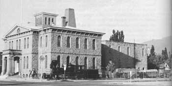 |
| The Carson City United States Mint, now operated as a museum by the State of Nevada, reflected Nevada's mineral wealth and was established by the Government when the output of the Comstock Lode overtaxed the San Francisco Mint. |
|
DANGBERG RANCH Nevada |
|
| ||
In 1853 Henry Dangberg crossed the Plains with a herd of cattle and established one of the first ranches in Nevada, in Carson Valley about 5 miles southeast of the Mormon agricultural colony of Genoa. Like the Mormons, he traded with the emigrants who were en route to California in the 1850's. Then the discovery of silver at the Washoe Dig around Virginia City further expanded his markets. Learning irrigation methods from the Mormons, Dangberg ditched his fields and grew hay. In 1864 he planted alfalfa, the first in Nevada. Selling his hay for $300 a ton, he profited more from farming than ranching. By 1879 his ranch, which comprised 4,648 acres and was watered by 40 miles of irrigation ditches from the Carson River, was valued at $60,000. Dangberg continued to expand his farming-ranching operations and when he died, in 1904, owned four ranches totaling about 36,000 acres. The original ranchhouse, much enlarged by additions in the 1860's and 1870's, is in excellent condition today. The ranch, still owned by the Dangberg family, is an outstanding example of diversified agriculture. It is not open to the public.
|
EUREKA Nevada |
|
| ||
Prospectors from Austin discovered in 1864 the first significant silver-lead deposit in the United States not far from the site of this town. They immediately organized the Eureka Mining District. Because the ore was a new and special type and no one knew how to smelt it, no rush of miners into the area occurred. Finally in 1869 Maj. W. W. McCoy devised a small smelter that could process the ore, and miners formed the town of Eureka. In 1870 San Francisco capitalists incorporated the Eureka Consolidated Mining Company, and in 1871 London financiers formed the Richmond Consolidated Mining Company. Three years later the San Francisco group constructed the narrow gauge Eureka and Palisade Railroad to the site. By 1876, 19 smelters were working the ore. In the 1870's the district yielded $26,050,304 in silver bullion and 225,000 tons of lead, an amount large enough to influence the world price. The peak population of the town was 5,000, but by 1890-91 mining had exhausted the bonanza ore bodies and mine flooding was a serious problem. The smelters closed down and most of the population departed. On several occasions fires and floods damaged the town.
Only seven original structures are still standing, including the county courthouse, the Eureka Sentinel Building, and three churches. The town today has a population of about 400.
|
GENOA (MORMON STATION) Nevada |
|
| ||
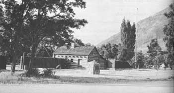
In June 1849 Hampden S. Beatie, en route from Salt Lake City to the California goldfields, arrived in the Carson Valley. Impressed with the spot, he decided to stay and erected a log cabin and a trading post to serve the thousands of emigrants passing by over the California Trail. In mid-1851 Col. John Reese and 18 other Mormons arrived in 10 wagons. Reese purchased the original cabin and also built a two-story log house and fort that served as a trading post and lodginghouse. Fencing and plowing 30 acres, he also began irrigated farming and sold produce to the emigrants. The little settlement that grew up, the first in Nevada, became known as Mormon Station; in 1856 it was renamed Genoa. Other Mormons continued to arrive until 1857, when Brigham Young ordered all Mormons to return to Salt Lake City. Although nearly depopulated by this exodus, Genoa survived and 2 years later had 150 inhabitants.
Reese's two-story log cabin, which also served as a Pony Express and Overland Stage station, stood until 1910, when fire destroyed it. Replicas of the station and stockade are now included in Mormon Station State Park, located on the original site of the cabin.
 |
| Replica of the Col. John Reese cabin and stockade at Mormon Station (Genoa) State Park, Nevada. As the Mormons spread out from Salt Lake City, they established outposts such as this where they practiced farming and sold their produce to emigrants. |
|
GOLDFIELD Nevada |
|
| ||
Goldfield, at the foot of Columbia Mountain, was the largest of the mining boomtowns of southwestern Nevada in the early 20th century. Late in 1902 William Marsh and Harry Stimler staked the first claim in the vicinity and soon struck gold. The next year other prospectors made rich strikes. Laid out as a tent town in 1904, within 2 years Goldfield had a population of 15,000 and hundreds of brick and wooden structures. The mines in the vicinity reached their peak in 1910, when they produced more than $11 million. After that their yield declined steadily; in 1922 it was only $150,000. The following year a fire, driven by desert winds, destroyed 53 blocks of buildings in the center of the town, and in 1932 a flood destroyed many others.
Because of these disasters, coupled with the closing of the mines, only a few buildings of the mining era have survived. The most interesting are the Esmeralda County Courthouse and Firehouse No. 1, both two-story stone buildings erected in 1907. Also of interest is the Goldfield Hotel, a four-story brick-and-stone building built in 1910 at a cost of $500,000 and containing 200 rooms.
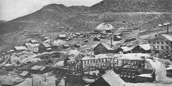 |
| Gold Hill, Nevada, in the 1860's. Located not far from Virginia City, Gold Hill shared in the Comstock Lode boom. Leading mines in the town were the Imperial, Empire, Challenge, and Confidence. Courtesy, National Archives. |
|
HAMILTON Nevada |
|
| ||
In 1865 a party of prospectors from Austin discovered silver at the site of Hamilton and founded the White Pine Mining District and a small mining town known as Cave City, which in 1868 they renamed Hamilton. A mill, which was erected in 1867, operated on a small scale for a few months until an Indian guided one of the miners to nearby Treasure Hill, which contained rich deposits of horn silver. As prospectors made other strikes and the news spread, Nevada experienced the greatest mining fever since the discovery of the Comstock Lode. The stampede to Hamilton moved the mining frontier 120 miles east of Austin into eastern Nevada. Approximately 10,000 men spent the winter of 1868-69 at the 8,000-foot altitude living in tents and caves.
Mining in the vicinity had a brief but spectacular history. Between 1869 and 1873 the mines yielded about $6,380,754. By 1875, however, all but one of them had ceased operations. The inhabitants of the town quickly departed, and by 1880 the population numbered only about 500. Fires in 1873 and 1886 destroyed most of the buildings, and Ely became the county seat. Today Hamilton is a ghost town; only a few ruins mark the original site. The most impressive of these are the stone walls of the two-story Withington Hotel.
|
LAS VEGAS Nevada |
|
| ||
The site of Las Vegas was a well-known camping area utilized by California emigrants traveling along the Mormon Trail to Los Angeles. The first settlers, in 1855, were Mormons sent from Salt Lake City by Brigham Young. He directed them to build a fort to protect emigrants and the U.S. mail route that had been newly established from Salt Lake City to Los Angeles. William Bringhurst and 30 other settlers built an adobe fort, 150 feet square and about 14 feet high, within which they erected log cabins. Outside, they constructed a dam, bridges, and fences. Reclaiming land by irrigation, they grew crops. They also unsuccessfully worked what they believed to be extensive lead deposits—actually galena, an ore-carrying silver—that were located about 18 miles to the southwest. They abandoned the mines when Young recalled all Mormon settlers to Salt Lake City in 1857. Remains of the fort may be seen in the city park on 5th Street.
|
MASON VALLEY RANCH Nevada |
|
| ||
This ranch was originally the headquarters of N. Henry A. Mason's ranch empire and after 1890 the center of Henry Miller's vast Nevada holdings. Mason, a Tennessean, emigrated to California in 1854 but 5 years later returned to Nevada, where he settled in what came to be known as Mason Valley. In 1860 he erected the first house in the valley, a small adobe tule-roofed ranchhouse, and began to supply the mining towns with beef. In 1871, using money that he obtained from Henry Miller, the California cattle king, Mason began buying ranches and expanding his range—selecting property along streams where he could control water rights. By 1880, when he owned more than 30,000 head of cattle and 90,000 acres, he was the largest rancher in Nevada. Drought and the severe winter of 1889-90 threw him heavily into debt, however, and in 1890 he sold out to Miller. The natural setting of the ranch is little changed today from the 19th century.
|
OVERLAND STAGE FARM Nevada |
|
| ||
In 1865 Ben Holladay's Overland Mail and Express Company established a farm in Ruby Valley, the first in eastern Nevada, to supply the company's Western Division. Because the division employed more than 79 men and utilized 268 horses, and since food and feed costs were high, the company decided to organize its own farm. The first harvest included 8,575 bushels of barley, 8,745 bushels of oats, 1,655 bushels of potatoes, 1,854 bushels of turnips, 1,000 bushels of carrots, and 78 bushels of beets. In 1867 the company erected a gristmill on the farm. The farm was in operation until 1869, when the company discontinued many of its routes because of the completion of the Central Pacific Railroad. The farm site is on the west side of Ruby Valley. No remains of the buildings can be seen, and the site is not marked.
|
PIOCHE Nevada |
|
| ||
In the winter of 1863-64 a Paiute Indian discovered silver ore at Meadow Valley, in southwestern Nevada. Shortly a group of miners formed the Meadow Valley Mining District (subsequently renamed the Ely District), but for 4 years mining was unproductive. In 1869 the miners founded the town of Pioche on the slopes of Ely Mountain and erected a smelter. The next year a rush occurred; the town underwent a boom and became the county seat. By 1874 its population was about 6,000. Between 1871 and 1873 production totaled $12 million, but after 1875 it rapidly declined and in 1885 ceased altogether. Fires in 1871, 1872, and 1876 destroyed much of the town, and a flood in 1874 swept away many other original buildings.
Based on railroad transportation and modern technology, mining revived in the 20th century and today Pioche is a small mining town. Few structures survive from the early days. The most impressive is the two-story stone-and-brick county courthouse, built in 1871 at a cost of $75,000 and now vacant.
|
RHYOLITE Nevada |
|
| ||
Rhyolite was the third mining camp founded in southwestern Nevada in the early part of the 20th century. After prospectors struck silver at Tonopah in 1900 and gold at Goldfield in 1902, they pressed the search for valuable metals farther south. In 1904 Frank Harris and E. L. Cross struck gold and filed the first claim near the site of Rhyolite, named for the principal rock in the vicinity. By 1907 the town had a population of 7,000 and rail connections with Tonopah and Las Vegas. In 1910, after producing about $3 million in gold, the deposits played out, the people departed, and Rhyolite became a ghost town.
Surviving structures include the large and elaborate stucco passenger depot of the Las Vegas and Tonopah and Tidewater Railroad, erected in 1907 and now used as a nightclub; and the ruins of two large three-story stone and concrete office buildings that were built in 1908 and utilized as banks and stores.
|
RUTH Nevada |
|
| ||
In the summer of 1900 Edward F. Gray and David P. Bartley, two young prospectors from Redding, Calif., came to try their luck at Ely, a gold-mining camp founded in 1868 but almost forgotten by the turn of the century. In the Robinson Mining District to the west, they took up two claims, the Ruth and the Kearsage, which showed promising copper outcroppings, though Nevada at the time produced little copper. The value of the ore was such that the men obtained financing and in 1902 formed the White Pine Copper Company, which soon reorganized into the Nevada Consolidated Copper Company. The company established the Nevada Northern Railroad, 141 miles in length, and erected a smelter, which began operating in 1908. From 1907 to 1917 the Ruth Mine yielded 617,785 tons of copper and enabled the company to pay $75,770,882 in dividends. In 1933 the Utah Copper Company and the Kennecott Copper Corporation bought out the Nevada Consolidated Copper Company, and in 1943 the name was changed to Kennecott Copper Corporation, Nevada Mines Division.
The smelter erected in 1907-08 has been modernized and is still being operated at the town of McGill, 20 miles distant. The center of Ruth today is the vast Liberty copper pit, more than 1 mile in diameter and nearly 1,000 feet deep. The company-owned town and plant buildings are all modern structures.
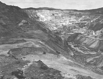 |
| Modern open-pit copper mine at Ruth, Nevada. Mining is still important to the Western economy. |
|
STAR CITY Nevada |
|
| ||
Star City was once the largest mining town in northwestern Nevada. In 1861 Isaac Miller and Jose Thacker discovered silver ore and established the Sheba Mine in Star Canyon, on the eastern slope of the Humboldt Range. Miners moved in and founded the Star City Mining District and camp. By 1864 the camp had 1,200 inhabitants and was the largest in what was then Humboldt County. It had a stamp mill, two hotels, a Wells-Fargo express office, post office, and telegraph office. In 1868 the mines failed, and the population departed. Today all traces of the town have disappeared, and only the scars of mining remain.
|
SUTRO TUNNEL Nevada |
|
| ||
In 1864 Adolph Sutro, a native Californian who operated a stamp mill in the Carson Valley, proposed to the Nevada Legislature adoption of his idea of digging a tunnel under the Comstock Lode to solve the problems of drainage, ventilation, safety, and access. He believed that the tunnel would drain the mines of water and prevent flooding. In 1865 the legislature granted him a 50-year franchise to construct the tunnel, wide enough for a double railroad track and more than 3 miles long. Sutro estimated the cost of construction at $3 million and set about raising the money, which he finally had to obtain from British sources. After many difficulties, in October 1869 construction began. Serious technical problems, the Panic of 1873, and political meddling hampered operations, but the crews finally completed the main tunnel, which was almost 4 miles long, in July 1878. Three years later they finished the 1-1/2 miles or so of lateral branches.
The tunnel, one of the great engineering feats of the 19th century, cost a total of $2,096,556. It was completed too late, however, for by that time the Comstock mines were failing. In 1879 Sutro resigned as superintendent of the Sutro Tunnel Company and within a year disposed of his stock—before its value collapsed. Subsequently he invested in San Francisco real estate, made a fortune, and served as mayor from 1894 to 1898. In 1889 the English banking firm of McCalmont Brothers foreclosed the tunnel and operated it until the 1930's. Today the entrance is barred by an iron grill gate. The vicinity of the tunnel entrance is a jumble of frame buildings, car tracks and ties, timber, and rusting equipment.
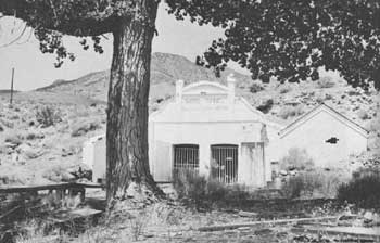 |
| One of the engineering wonders of the world, the Sutro Tunnel, completed in 1878 and running under the Comstock Lode to drain and ventilate the mines, was also one of the fiascos of the century, for it was completed too late to be of substantial value. Pictured in this modern photograph is the entrance. |
|
TONOPAH Nevada |
|
| ||
In 1900 James Butler, a rancher from the town of Belmont, struck gold and silver at the site of Tonopah. Walter Gayhart of Austin laid out the town, which soon boomed. Most of the original owners of claims leased their mines to capitalists in return for 25 percent of the gross output. In 1903-4 the Tonopah and Goldfield Railroad provided a connection with the Southern Pacific terminal at Mina. In 1913 production reached a peak of $9,500,000, but by 1921 only four mines were in operation.
Tonopah is still a busy town, surrounded by the tailings, head-frames, and mills of its boom period. It is the best preserved of the 20th-century boomtowns in southwestern Nevada. Among the more interesting structures are the Tonopah Club, formerly a gambling hall; the five-story Mizpah Hotel; and the huge yellow stone Nye County Courthouse. Small-scale mining is still done in the vicinity today.
|
UNIONVILLE Nevada |
|
| ||
In 1861 prospectors from California began exploring what was then part of Humboldt County in Nevada, and two of them struck silver. A rush ensued and the miners organized the Buena Vista Mining District and the mining camp of Dixie. At the outbreak of the Civil War, the residents changed the name of the camp to Unionville, which served as the county seat of Humboldt County between 1862 and 1873. During its boom period the town had about 100 buildings and a population of 600, but after 1870 many of its inhabitants moved eastward to new silver camps. Of all the early boom camps in northwestern Nevada, Unionville is the only one in which any original buildings are still standing. Six of the original one-story miners' residences, in fair condition, are used today as dwellings.
|
WILLIAMS RANCH Nevada |
|
| ||
This ranch was typical of the 500 or so small stock ranches that were being operated in Nevada by 1885. Founded by George B. Williams in 1876 at Eastgate, which had been a stage station and stopping place for travelers since 1862, it ran cattle and sheep. In 1879 Williams erected a small one-story, tufa-block house that had a sod roof. In 1908 he built a second home, of similar construction but consisting of 12 rooms, adjacent to the original. Both structures are still standing, but have been altered considerably. The ranchhouse of 1879 is now a store and gas station.
 |
 |
http://www.cr.nps.gov/history/online_books/prospector-cowhand-sodbuster/sited8.htm
Last Updated: 22-May-2005