


Survey of Historic Sites and Buildings
 |
AMADOR CITY California |
|
| ||
In 1848 prospectors discovered small placer deposits of gold on Amador Creek, began mining on a limited scale, and founded Amador City. Three years later they struck gold-bearing quartz veins, and quartz mining became the town's major industry once improved methods of working quartz evolved. In 1869 the leading mine, the Keystone, reached its peak production, but well into the 1880's it continued to yield considerable gold.
A few original buildings still stand in Amador City. These include a one-story stone store, now a museum; the Amador Hotel, a two-story frame structure; the Imperial Hotel, a two-story brick building, which has iron shutters and a balcony; and the Mine House, a large two-story brick building that was once the office and residence of the Keystone Mine superintendents and is now a motel.
|
ANGELS CAMP California |
|
| ||
James H. Carson and George Angel discovered placer deposits of gold near the site of this town in 1848. Angel established a trading post, and the mining camp that sprang up around the post became known as Angels Camp. After the miners exhausted the placers, they discovered gold-bearing quartz veins. By 1857, 11 quartz mills were operating. While visiting the camp in 1865, Mark Twain heard the tale that he soon fashioned into his famous short story "The Celebrated Jumping Frog of Calaveras County," which first brought him national attention. Few original buildings have survived in the modern town of Angels Camp because of disastrous fires in 1856 and 1885. One of the few reminders of the city's past is a statue of Mark Twain, which stands in a small park.
 |
| Familiar relics of the mining frontier are abandoned headframes and clusters of dilapidated shacks. |
|
AUBURN (OLD TOWN) California |
|
| ||
Auburn—only about 20 miles away from Coloma, the scene of the first gold strike in California—was one of California's earliest mining camps. It was first known, for a few months, as North Fork Dry Diggings. As early as May 1848 prospectors were mining rich placers in the vicinity. In 1850 the town had a population of 1,500. Despite serious fires in 1855, 1859, and 1863, it continued to grow and was an important center for mine staging and freighting until 1865, when the Central Pacific Railroad reached it.
The original section of Auburn, now known as Old Town, lies at the head of the Auburn Ravine, bounded by Lincoln Way, Court, and Commercial Streets. Still standing are 10 brick and stone commercial buildings, one and two stories in height, which include the newspaper office, Masonic hall, bank, post office, fire house, and several stores.
|
CHINESE CAMP California |
|
| ||
This town was founded in 1849 by a small group of Englishmen who were importing Chinese to work in the California mines. It soon became the headquarters for four of the six Chinese companies, or tongs, in the State. In 1855 its population reached a peak of 5,000. The following year a tong war occurred 2 miles to the west, where 900 members of the Yan-Wo Tong met 1,200 members of a rival faction, the Sam-Yap Tong. After 2 hours of combat, 4 were dead, 4 wounded, and 250 in jail.
Little of the original town remains today. A number of one-story stone buildings stand on the quiet main street, along with an occasional Chinese Tree of Heaven. The present post office, a one-story brick-and-stone structure, was originally built in 1854 as a two-story general store. St. Francis Xavier Catholic Church, a frame structure, was constructed in 1860.
|
COPPEROPOLIS California |
|
| ||
Prospectors founded this town in 1861, the year after they struck a rich vein of copper ore. The Union Copper Mine and the Keystone and Empire Mines soon began operating. Between 1862 and 1865 the Copperopolis vicinity was the principal copper-producing area in the United States. Its ore moved by cart to Stockton, then by river boat to San Francisco, and finally by oceangoing vessels to Wales for smelting. By 1865 annual production in the Copperopolis area totaled $1,500,000. In 1866 a drop in the world price of copper brought mining to a halt, and the following year a fire destroyed much of the town, In the 1870's a rise in protective tariff duties caused a brief revival in mining, but the expanding output of the copper mines in Michigan could not be challenged. By 1872 the Copperopolis mines had been abandoned.
A few buildings erected in the 1860's are still standing, including the Federal Armory, the two-story brick warehouse and office of the Copper Consolidated Mining Company, and the brick Odd Fellows (I.O.O.F.) Hall.
|
DOWNIEVILLE California |
|
| ||
Set in one of the most rugged and elevated regions of California, Downieville was founded after gold was discovered at the site late in 1849. By the following spring, just after it became the county seat, some 5,000 miners had rushed to the vicinity and the town had become the center for the surrounding camps. In 1852 and 1858 fire destroyed much of it, but each time the residents rebuilt. In spite of fire, weather, and flood, a few brick and stone buildings dating from the 1850's and 1860's still stand along the main street, as well as five or six frame residences and two churches.
|
EL DORADO California |
|
| ||
Mud Spring, later renamed El Dorado, was originally a watering place on the Carson Branch of the California Overland Trail. Then in 1849, when prospectors discovered gold placers in the vicinity, a booming mining camp and freighting center sprang up. In 1855 it incorporated as the town of El Dorado, but within 2 years began to lose population to other mining areas. Because a fire in 1923 destroyed much of the original business district, only a few structures remain today, including a frame hotel, a store, and a block of ruined stone walls of former buildings.
|
GRASS VALLEY California |
|
| ||
Prospectors discovered placer gold in 1849 near the site of Grass Valley, and a small camp sprang up in Boston Ravine. After the miners struck gold-bearing quartz the following year at Gold Hill, the town of Grass Valley grew up around the camp. Before the year ended, the first stamp mill in California and the Far West began operation, but after 2 years it went bankrupt. Improved techniques gradually evolved, however, and by 1856 five quartz mills and seven mines were operating. In 1880 the town's population was more than 5,000. Among the great gold mines in the world is the Empire, discovered in 1850 and now located on Colfax Road 1 mile southwest of town. Still in operation, it has more than 190 miles of tunnels and its deepest shaft is about 4,000 feet.
Because the inhabitants immediately rebuilt and kept modernizing after a fire in 1855 destroyed most of the buildings in the town, few original buildings have survived, though the town contains probably the most extensive mine dumps and surface mine structures in California. Among the most interesting of the older homes is that of Lola Montez, the famous actress and dancer of the mining era, who retired in Grass Valley.
|
HOCK FARM California |
|
| ||
Named for an Indian village on the Feather River, this farm was established in the winter of 1841-42 by John A. Sutter, who at first had an adobe ranchhouse erected on the west riverbank and later other buildings. By 1848 the herds consisted of 12,000 cattle, 2,000 horses, and perhaps as many as 15,000 sheep. In 1849, after being forced to sell his fort, Sutter moved to Hock Farm and erected a large Monterey colonial dwelling—a two-story frame-adobe house, where in 1850 his family joined him. At the time the farm consisted of 1,200 acres of land, of which about 200 were improved. Sutter resided there until 1865, when a fire destroyed the house. He then returned to the East, where he died in 1880. No remains of the Hock Farm buildings are extant, but the site is a Registered State Historical Landmark. A memorial is located in Yuba County, on the Garden Highway, 8 miles south of Marysville.
|
HORNITOS California |
|
| ||
Hornitos ("Little Ovens"), founded by Mexican miners in 1850, is one of the few camps in the Mother Lode country that still reflects the Mexican influence. Founded by Mexicans who had been driven out of nearby Quartzburg by an American vigilance committee, it was built in Mexican style around a plaza. When the placers at Quartzburg gave out, the Americans moved to Hornitos, which in corporated in 1861, and introduced law and order.
Well off the beaten track, the modern town retains much of its original atmosphere and setting. A number of buildings are unaltered, and a few of them are still occupied, mostly by Spanish-speaking people. Adobe-stone structures with massive iron doors stand along the narrow and unpaved streets. Among the 20 original structures, the most interesting are the post office, formerly a beer hall; the Wells-Fargo office, now maintained by the Native Sons of the Golden West; the one-story stone Masonic Hall; and the ruins of the D. Ghirardelli store.
|
JACKSON California |
|
| ||
The first settlers at the site of Jackson, when it was named Botilleas, were miners who arrived in 1849 after prospectors struck placers of gold in the area. Most notable of the deposits were located at Jackson Gate, 1 mile north of town, and at Tunnel Hill, 1-1/2 miles to the south. By the end of 1850 the town had nearly 100 houses, but a fire ravaged it in 1862 and a flood in 1878. Many of the old buildings, however, are still standing along the narrow main street of the town, although nearly all of them have been altered with new fronts and neon signs. The Argonaut and Kennedy Mines, which yield gold-bearing quartz, are still operating.
 |
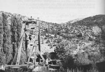
| One of the spectacular sights of the California Mother Lode country, at Jackson. These giant water wheels, 68 feet high, lifted tailings from the Kentucky Mine, in the background. |
|
LASSEN'S RANCH California |
|
| ||
Peter Lassen, a blacksmith and native of Denmark, emigrated to the United States in 1829 and settled in Missouri. A decade later he moved to Oregon country, where he stayed a year before moving to Mexican California. In 1844 the Mexican Government made him a provisional grant of 5 square leagues (about 26,000 acres) in the northern Sacramento Valley that included the site where he had already built an adobe house and trading post. When explorer John C. Frémont visited the ranch in 1846, he found that Lassen had stocked it with cattle and was gradually bringing the land under cultivation with Indian labor. After being unsuccessful in efforts to promote a townsite on his ranch, Lassen sold it in 1852 and turned to trading and mining. In 1859 Indians killed him. No remains of the ranch are extant.
|
MARIPOSA California |
|
| ||
On learning of the discovery of gold at Coloma, in 1848 the famous soldier-explorer John C. Frémont "floated" his Mexican land grant of 44,386 acres, Rancho Las Mariposas, about 50 miles eastward to include mountain country that might contain precious minerals. In the summer of 1849, gold-bearing quartz veins were first discovered in California at his ranch, on the southern end of the Mother Lode. Frémont hired 25 Mexican miners and in August 1850 began operating a quartz mill, around which a small town grew up. Although by 1862 he had obtained some $3 million in gold, he profited little because of the chicanery of business associates, high operating costs, and legal battles over title to his ranch. In 1863 he lost control of the Mariposa. In the meantime the town had grown, in 1854 having become the county seat, and mining in the vicinity continued to attract settlers. By 1872 some $20 million had been extracted from the Mariposa mines.
Mariposa is still a prosperous town, but few early buildings remain. Probably the most interesting is the two-story frame court house, which has functioned as such since its construction in 1854. Fremont's quartz mine, the Princeton, is located just south of the village of Mount Bullion, about 6 miles southwest of Mariposa on Calif. 49. His home (1851-61) is in Bear Valley, 12 miles northwest of the city on the same highway. At Bear Valley may be seen the ruined walls of his company store and the foundation stones of his house. Still standing there, too, are a block of two-story stone and adobe structures, including saloons, stores, and hotels, which were built in the 1850's.
|
MARSH RANCH California |
|
| ||
John Marsh, a native of Massachusetts, arrived in southern California in January 1836 and obtained a license to practice medicine from the Mexican Government. Moving 2 years later to northern California, he purchased the 17,400-acre Rancho Los Medanos (or Meganos) from José Noriega, and constructed a simple four-room adobe ranchhouse with a thatched roof. He raised cattle, sheep, and horses and engaged in some subsidiary farming. In 1856 he erected a new $20,000 home for his growing family. Called the Stone House, and designed by Thomas Boyd in Gothic and Italian villa styles, it was a large three-story stone-and-brick edifice and had a 65-foot tower. The same year, when Marsh was 52 years of age, he was murdered. The Stone House and 7.3 acres of the original ranch have been set aside as a county park. No remains of the original adobe ranchhouse are extant.
|
MARYSVILLE California |
|
| ||
This river-port town, lying at the head of navigation on the Feather River, the main tributary of the Sacramento River, was surveyed in the spring of 1849 by Charles Covillaud. Almost immediately it became an important steamboat landing and a major interior distributing point for the northern mines in the Sierra Nevada. By February 1850 it had 500 inhabitants, and about 1,000 miners were working in the immediate vicinity. Following the Civil War, mining declined and the construction of railroads caused a serious drop in Marysville's river trade. By 1880 the population had fallen to 4,300 from a peak of 8,000 in 1855. The town suffered in the early days from both fire and flood. Major conflagrations struck in 1851, 1854, and 1856. Four floods, in 1852-53, 1861-62, 1866, and 1875, destroyed many of the original buildings. Those that remain include the Yuba County Court House, St. Joseph's Catholic Church, and the Ramirez House. They are all brick structures in the Gothic Revival style.
|
MOKELUMNE HILL California |
|
| ||
In 1848 a party of prospectors from Oregon Territory discovered gold near the site of this town, which arose the following year. In the 1860's, as the miners depleted the placers, the town began to decline and it suffered from damaging fires in 1854 and 1874. Today, little disturbed by modern intrusions, it is a good example of an early mining town. It still has a number of unaltered original buildings, including the two-story brick Calaveras County Court House, built in 1852 and used as a courthouse until 1866 and as an annex of the Leger Hotel since 1879; the frame Congregational Church, built in Greek Revival style in 1856; and the Odd Fellows (I.O.O.F.) Hall, a three-story brick building built in 1854 as an express office and acquired in 1861 by the Odd Fellows.
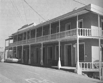 |
| This building in Mokelumne Hill, California, now an annex of the Leger Hotel, served as the Calaveras County Court House during the period 1852-79. Mokelumne Hill, a mining camp and trading center, was founded in 1850. |
|
MURPHYS California |
|
| ||
Daniel and John Murphy discovered rich placer gold beds on Angel's Creek in July 1848. The town that arose—not far from Angels Camp—was first known by the name of Murphy's Diggings, then as Murphy's Camp, and finally as Murphys. In 1855 the population reached its peak, but 4 years later fire destroyed much of the business district. Considerably isolated today, the town has survived with the setting largely unaltered. A number of the original buildings still stand, including the Mitcher Hotel, a large two-story stone structure equipped with iron doors and balcony, built in 1855; Thorpe's Bakery, a one-story stone building, constructed in 1856; two one-story stone stores dating from 1855; a Wells-Fargo express office; and a schoolhouse built in 1860.
|
NEVADA CITY California |
|
| ||
After the discovery of placer deposits of gold at the site of Nevada City in September 1849, a small mining camp sprang up on Deer Creek. Because the placers proved to be rich, a major rush ensued and by the end of the first year the town had more than 400 buildings and a population of 2,000. An additional 8,000 men lived in a dozen nearby mining camps. When fire destroyed half the town in 1851, the citizens rebuilt with brick, but within a couple of years mining fell off, and the population declined. The development of techniques for the processing of quartz and the advent of hydraulic mining in 1856, however, led to a revival, and in 1880 the population numbered 4,022.
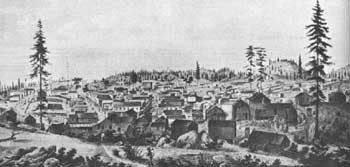 |
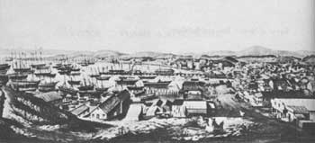
| Nevada City, California, was founded after prospectors discovered gold nearby in 1849. First known as Deer Creek Diggings and Caldwell's Store, it soon took the name of Nevada, or Nevada City. Courtesy, Bancroft Library, University of California. |
Today Nevada City is probably the best preserved mining town in northern California. Many brick and stone buildings dating from the middle 1850's still line its crooked, hillside streets, including Fire House No. 1, the National Hotel, and the assay office. This assay office correctly identified as silver the puzzling ore specimens from the Comstock Lode of Nevada.
|
NORTH BLOOMFIELD California |
|
| ||
In 1851 prospectors ran across placer deposits of gold at the site of North Bloomfield. A mining town, first named Humbug City for the creek on which it was located, sprang up the same year and by 1856 had 400 inhabitants. But until the invention of hydraulic mining progress was slow in the vicinity. In 1852 a Frenchman named Chabot used a hose without a nozzle on his claim at the nearby Buckeye Hill Mine to sluice away the gravel he had loosened with his pick. The following year Edward E. Matteson, adding a nozzle to a hose, invented hydraulic mining. The increased pressure provided by the nozzle eliminated costly pick and shovel work. Matteson first applied his invention at the American Hill Mine at neighboring Nevada City.
Improved by many individuals, the process was immediately adopted at North Bloomfield, which between 1855 and 1884 was the largest hydraulic mining center in California. To supply the vast quantities of water needed, the North Bloomfield Company constructed two large reservoirs high in the Sierra Nevada, 6,000 feet above sea level and about 3,000 feet above the town. A system of canals and flumes about 100 miles long transported the water.
North Bloomfield is now almost deserted, and only a few original frame structures remain. At the edge of town is the colossal pit of the Malakoff Mine, second only in size to the La Grange pit near Weaverville, Calif.
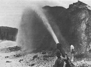 |
| As mining technology advanced, the hydraulic method of loosening paydirt was invented. Here a "monitor" is being used near Yuba City, California. Courtesy, Wells-Fargo Museum, San Francisco. |
|
NORTH SAN JUAN California |
|
| ||
In 1853 prospectors discovered gold at San Juan Ridge, just north of the site of North San Juan. By 1859 the town had a population of 1,000 and consisted of 8 brick buildings, a church, a public school, 3 hotels, 2 restaurants, a brewery, 4 sawmills, an iron foundry, some 60 stores and saloons, and about 250 houses. Hydraulic methods were used to work the deposits on San Juan Ridge.
Today the town has a small population, but several original structures have survived, including four or five brick buildings. The most important are the Odd Fellows Hall (1860); the town-hall (1857); and the frame Methodist Church (1856), built in the Greek Revival style.
|
PLACERITA CANYON California |
|
| ||
While looking in this canyon for stray cattle, on March 9, 1842, Francisco Lopez y Arballo first discovered placer gold in commercial quantities in California. The deposits were worked mainly by Francisco Garcia, an experienced miner from Sonora, Mexico, who brought others with him from his home state. By the end of 1843 the men had obtained about $42,000 worth of gold nuggets from nearby San Feliciana Canyon in the San Fernando hills, as well as an unknown amount from Placerita Canyon. After about 5 years they exhausted the deposits. Placerita Canyon is a Registered State Historical Landmark and also a State park.
|
PLACERVILLE California |
|
| ||
Placerville was one of California's earliest mining camps, for prospectors struck gold at the site in the summer of 1848. The camp that grew up was first known as Old Dry Diggings, but early in 1849, after the residents hanged several alleged robbers without benefit of trial, they renamed it Hangtown. The following year they again renamed it, as Placerville. When incorporated in 1854, the town had a population of 1,944. By 1856 gold production had fallen off, and two large fires swept the town, which began to decline. The citizens rebuilt with brick and stone. Their faith proved to be justified, for in 1860 the town became the gateway to the Comstock Lode area of Nevada. Also a major supply and transportation center for California mining camps, it was served by the first trans continental telegraph line and was an important depot on the Carson Branch of the California Overland Trail, the Central Overland Mail and Stage Line, and the Pony Express.
Three men who later became famous began their careers at Placerville: Mark Hopkins sold groceries door to door, J. M. Studebaker built wheelbarrows for the miners, and Philip Armour ran a butcher shop.
On Main Street of modern Placerville are a number of buildings constructed about 1860: Placerville Academy, now the Ivy House; the Methodist Church; and St. Patrick's Catholic Church. The general setting of the town has been much altered by a superhighway and many modern buildings.
|
RANCHO CHICO California |
|
| ||
John Bidwell, a leader of the first organized party of overland emigrants to reach California, was later a successful agriculturist, horticulturist, and town builder. After his arrival in 1841, he entered the employ of John Augustus Sutter as soldier, bookkeeper, and manager and then became an officer in Fremont's California Battalion. In 1847 he acquired Rancho Chico, which consisted of approximately 25,000 acres, and the following year erected a small log cabin. Maintaining an experimental orchard, he eventually planted 65,276 fruit and nut trees on an 1,800-acre tract; and pioneered raisin growing and olive oil manufacture in the region.
In 1860, on his ranch, Bidwell founded the town of Chico, for which he donated much of the land. Five years later he retained Henry William Cleaveland, a San Francisco architect, to design a new home, a large two-story stone mansion. He began construction in 1865 and completed it 3 years later, at a cost of $56,000. He died in 1900. In 1921 the State of California acquired the mansion as a part of Chico State Normal School. In 1961 the California Division of Beaches and Parks took over the structure and made plans to restore it as a historic house and a State historical monument.
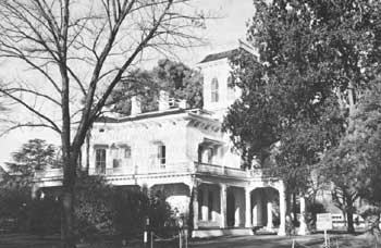 |
| Ranchers built some of the finest homes in early California, such as John Bidwell's Italian villa mansion, headquarters of Rancho Chico. |
|
RANCHO EL TEJON California |
|
| ||
In 1852 Edward Fitzgerald Beale, a young U.S. Navy lieutenant who had served with distinction at the Battle of San Pasqual during the Mexican War in California, was appointed Superintendent of Indian Affairs for California and Nevada. He instituted a new Indian policy that called for the establishment of a series of small but well-defined reservations where the Indians were to be concentrated and taught farming and simple trades so that they could become self-supporting. In 1853 he launched his first reservation of this type, at Tejon, and the following year the Army founded Fort Tejon nearby to protect the Indians from the whites.
Removed as superintendent for political reasons in 1854, Beale turned to ranching in the San Joaquin Valley. Near Tejon, at a cost of about 5 cents an acre, he bought four contiguous Mexican ranchos (Castac, Liebre, El Tejon, and Los Alamos y Agua Caliente) and formed a 195,000-acre ranch. When the Tejon Reservation was disbanded in 1863, he invited the Indians to live on the ranch. By 1870 he was running more than 100,000 sheep, which were tended by 300 Indian shepherds. In addition to ranching, he also pioneered in irrigating the San Joaquin Valley. In this manner he cultivated 1,900 acres.
Beale died in 1893, and in 1912 his heirs sold the ranch to Harry Chandler. Part of the ranch is still in operation. The original ranch headquarters buildings have disappeared, as have the adobe quarters of the Indians. Fort Tejon State Historical Monument contains three restored adobe buildings—a barracks and two officers' quarters.
|
RANCHO JACINTO California |
|
| ||
In 1867 Dr. Hugh James Glenn, who had come to California from Missouri in 1849 and for a while tried his luck in the goldfields, purchased this ranch, which originally consisted of a 7,000-acre Mexican grant dating from 1844. Adding to his holdings other lands in the vicinity, he soon owned 55,000 acres. On 45,000 of them he grew wheat, a task that required 108 teams of mules. Between 1874 and 1883 he was the leading wheat farmer in the United States. He also ventured into the cattle industry through partner ships. The firm of French and Glenn established a 132,000-acre ranch in Harney County, Oreg., which ran perhaps 30,000 cattle and 3,000 horses. With his nephew, E. W. Crutchers, Glenn also owned another large ranch in Paradise Valley, Nev., where another 15,000 cattle and 1,000 horses grazed. In 1883 Dr. Glenn was murdered. In the 1890's his California estate was subdivided into small farms, but the old Glenn mansion still stands at Jacinto.
|
RANCHO LAS FLORES California |
|
| ||
In 1841 the Mexican Government granted to Pio and Andres Pico the ranchos San Margarita and Las Flores, which totaled 100,000 acres. On Rancho Las Flores, Pio Pico erected a large one-story adobe ranchhouse, which had a wide porch on two sides. Economic difficulties, however, forced him in 1864 to sell the two ranches to his brother-in-law, John Forster, who combined them with land he already owned in the vicinity to form one vast ranch of 187,000 acres. Forster resided on the ranch until he died in 1882. During World War II, the land became a U.S. Marine Corps training base. The old ranchhouse, somewhat remodeled by the Marine Corps but maintaining in general its original appearance, is still standing.
|
RANCHO LOS CERRITOS California |
|
| ||
This rancho was originally part of one of the first two provisional land grants made by the King of Spain in California for ranching purposes. In 1784 the King granted to Manuel Nieto all the land between the Santa Ana and San Gabriel Rivers and from the foothills of the San Gabriel Mountains to the Pacific Ocean. Nieto agreed to build a stone house and to maintain at least 2,000 head of livestock on the ranch. In 1834, when his heirs finally received full title to the 200,000-acre ranch from the Mexican Government, they divided it into five separate ranches. At the time John Temple, a young New Englander, married a granddaughter of the original owner, he acquired a twelfth interest in the ranch. In 1843 he became sole owner of the 27,000-acre Rancho Los Cerritos by buying out the other heirs, and soon was pasturing 15,000 cattle, 7,000 sheep, and 3,000 horses. Temple later acquired Mexican citizenship and became very wealthy. In the 1850's he was an important builder in the city of Los Angeles. He sold the ranch in 1866 to Flint, Bixby, and Company, which operated it as a sheep ranch until 1882, when the company subdivided it for real estate and town development purposes.
The magnificent Los Cerritos ranchhouse, probably the most impressive in southern California during the Mexican period, is to day the largest restored adobe structure in the region. Erected by Temple in 1844 in Monterey colonial style, it is now exhibited as a historic home by the city of Long Beach. Its central two-story portion is 100 feet long, and at each end are one-story wings, each 145 feet long. The wings are joined together by an adobe wall, which forms an enclosed patio. Unfortunately the original ranch setting has been destroyed almost completely by urban growth and the intrusion of Signal Hill district oil wells.
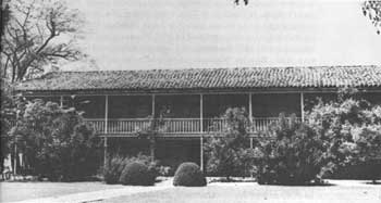 |
| Rancho Los Cerritos ranchhouse was probably the largest and most impressive in southern California during the Mexican period. Now located within the city of Long Beach, it is one of the largest restored adobe structures in California. |
|
RANCHO NIPOMO (WILLIAM G. DANA RANCH) California |
|
| ||
William Goodwin Dana, a native of Boston and cousin of Richard Henry Dana, Jr., author of Two Years Before the Mast, emigrated to California in 1826 and settled at Santa Barbara. Two years later he married a Mexican girl and in 1835 became a naturalized Mexican citizen. In 1837 the Mexican Government granted him a 37,000-acre tract, Rancho Nipomo, upon which he settled in 1839. He resided in a large 13-room adobe house that he designed himself. Employing Indians, he stocked his ranch with cattle and engaged in the hide and tallow trade. For many years the Dana heirs owned the house and surrounding land. In 1954 the San Luis Obispo Historical Society acquired the old house and hopes to restore it.
|
RANCHO SANTA RITA (MILLER-LUX HEADQUARTERS) California |
|
| ||
In 1850 Henry Miller arrived in San Francisco, where he opened a butcher shop. In 1858 he formed a partnership with Charles Lux, another German immigrant. Five years later they purchased their first ranch—8,835 acres of Rancho Sanjon de Santa Rita—together with its "Double H" brand and 7,500 head of cattle. By 1866 Rancho Santa Rita had been extended until it was 68 miles in length. Using this ranch as a base, Miller and Lux began building the largest ranching empire on the Pacific coast. Acquiring thousands of acres in California, Nevada, and Oregon, by 1888 they owned 750,000 acres, two-thirds of which were fenced, and 100,000 cattle and 80,000 sheep. They ran a channel northward 30 miles from the San Joaquin River, 12 miles above its bend, to irrigate 500,000 acres of land. Only one original building has survived: a small one-story frame building at one time used as a store but now considerably altered. The once vast ranch has been reduced to an 1,800-acre farm.
|
SAN BERNARDINO MORMON COLONY California |
|
| ||
In 1851 Brigham Young directed Amasa M. Lyman and C. C. Rich to lead 500 Mormons from Salt Lake City to the vicinity of Cajon Pass in California and establish an agricultural colony and Mormon outpost. Upon their arrival, the Mormons purchased Rancho San Bernardino from the Lugo family for $77,000 and laid out the town of San Bernardino, along with adjacent farms. To protect themselves from possible Indian attacks, they erected a fort and stockade that measured 300 by 720 feet and enclosed about 8 acres of land. The settlement prospered until 1857, when Young ordered the colonists to return to Salt Lake City. Most of the settlers obeyed the order, and the San Bernardino colony was abandoned. No remains of the original fort survive, but the site is a Registered State Historical Landmark.
|
SAN FRANCISCO California |
|
| ||
The sleepy city of San Francisco, which had originated in 1835 as the Mexican village of Yerba Buena and which had been the site of a Spanish mission and presidio since the year 1776, was jolted by the discovery of gold at Coloma in 1848. At first, while the news was on the way eastward, the city was almost depopulated by a mass emigration of males to the goldfields. The next year, however, hordes of gold seekers from all over the world began to arrive. By 1850 the population was 25,000, many of whom had settled in the city instead of continuing on to the goldfields.
As the treasures of the mines poured in, the city became the economic capital of the Far West. Prices skyrocketed, lodgings became scarce, and vice and gambling prospered in the crowded and chaotic new metropolis. Portsmouth Square was studded with saloons and gambling halls, and gang warfare broke out on the dark streets. By 1855 the citizens had formed a vigilance committee. A series of fires, in 1849, 1850, 1851, and 1852, destroyed the tents and shanties of the first boom period, and a law of 1853 required that all buildings in the business district be constructed of brick and stone. Late in the century the Klondike gold strike brought new wealth and another boom. By 1903 the population was 425,000.
The great earthquake and fire of 1906 destroyed almost all of the original business district except for the section known today as Jackson Square. This section contains 10 brick and stone buildings dating from the 1850's and 1860's that have been carefully preserved and restored. Although used for modern commercial purposes, the buildings convey some of the flavor of early San Francisco. The Old United States Mint, located at the corner of Fifth and Mission Streets, is eligible to be registered as a National Historic Landmark.
 |
| View of San Francisco in 1850, lithographed from a drawing by William B. McMurtrie. Courtesy, Bancroft Library, University of California. |
|
SANTA ROSA ISLAND (VAIL AND VICKERS RANCH) California |
|
| ||
In 1843 the Mexican Government granted the brothers Carlos Antonio and Jose Antonio Carrillo all of Santa Rosa Island, about 62,000 acres, for ranching purposes. The very next year the brothers, in turn, gave the island to two of Garlos' daughters, Mrs. A. B. Thompson and Mrs. John C. Jones, as a wedding gift. The ranch was then stocked with sheep. In the 1880's Alexander P. and W. Henry More of Boston purchased it and erected a New England style framehouse and barns. The Mores were succeeded as owners in 1902 by the Vail & Vickers Cattle Company, which replaced the sheep with beef cattle. The island today is still a cattle ranch, and the house, stables, hay barns, and bunkhouses erected in the 1880's are still being used.
|
SHASTA California |
|
| ||
Between 1850 and 1852 miners formed a new gold-mining district at the head of Sacramento Valley, but it never achieved the importance of those in the Sierra Nevada. Shasta evolved in 1850 from Reading's Spring, a trading center that had been established the previous year to supply the isolated northwestern mining camps in the district. Supplies, which reached it by wagon, were packed over the mountains on mules. The period of the town's greatest prosperity was between 1852 and 1857, when more than 2,000 mules were transporting supplies to the mines. After 1857 the gold deposits began to play out, and in 1872 the California and Oregon Railroad bypassed the town. As a result the population, which in 1854 had reached 1,500, by 1880 had declined to 448. Fires in 1853 and 1878 destroyed many of the original buildings.
Today Shasta is a State historical monument that with three exceptions consists of crumbling walls and deteriorating foundations. Still intact are the two-story brick Masonic Hall and store (1853); and the one-story brick county courthouse (1855), which now serves as a museum. On a hill overlooking the town is a two-story framehouse that was once owned by Dr. Benjamin Shurtleff. Built in the Greek Revival style in 1851, it was prefabricated in Boston, shipped around the Horn to San Francisco, carried to Sacramento by river boat, and then freighted by wagon to Shasta.
|
SONORA California |
|
| ||
A party of Mexican miners discovered rich placer deposits of gold on Woods Creek in August 1848, and nearby grew the town of Sonora Camp, or Sonora for short. Attracted by the deposits, other Mexicans, as well as Anglo-Americans, came into the area, and by 1849 the population of the town was 5,000. Known as the "Queen of the Southern Mines," Sonora was not without violence. In June 1850, when the Americans imposed a $20 tax on all foreign-born miners, most of the foreigners left at once. Ravaged by three fires—in 1849, 1852, and 1853—the town was rebuilt each time. By 1865 its mines were almost exhausted, and in 1880 its population was only 1,490.
Today the few original buildings that have survived have been considerably altered. The citizens have replaced most of the older structures with more modern ones. The outstanding building—one of the most beautiful in all the Mother Lode country—is St. James Episcopal Church, a graceful frame structure on North Washington Street. Completed in 1859, it is only 100 yards from the Big Bonanza Mine, reputedly the richest single-pocket mine ever discovered in California.
|
STOCKTON California |
|
| ||
Lying on the lower San Joaquin River at the head of navigation, the river port of Stockton sprang into life in 1849-50. From there pack trains and wagons hauled supplies to the mining towns located in the interior. By the mid-1850's the town had some 200 framehouses, and in 1851 the first brick building was constructed. Today only three or four buildings of the gold-rush period survive. Among these are the two-story brick Forty-Niner Drugstore, located at the corner of Main and El Dorado Streets, erected about 1852; and the I.O.O.F. Hall, situated on the west side of El Dorado Street between Weber Avenue and Main Street, built in 1853.
|
VOLCANO California |
|
| ||
Prospectors discovered placer gold at Volcano, or Soldiers' Gulch, in 1848, and a mining camp sprang up 2 years later. It quickly attracted a population of 5,000, but by 1855 the miners had almost depleted the rich deposits. Hydraulic mining came into use shortly thereafter, and the town gained a new lease on life. Well off the beaten path today, it preserves an authentic gold-rush flavor. Among the major surviving buildings from the 1850's and 1860's are the St. George Hotel, a three-story brick building; the two story Odd Fellows and Masonic Hall; the Adams Express Office; two one-story saloons; and a store. All of these are of brick or stone construction.
|
WEAVERVILLE California |
|
| ||
John Weaver discovered gold on Weaver Creek in 1849. In mid-1850 miners established the town of Weaverville, which immediately became the county seat. By 1858, after two disastrous fires and rebuildings, the town had 25 stone and brick structures and had reached its peak population of about 1,800. Like Chinese Camp, it was also the scene of a tong war, in the 1850's.
A considerable number of buildings have survived with relatively little change, including the courthouse, the Masonic Lodge, and several stores. A reminder of the 2,500 Chinese who once worked in the vicinity is the Weaverville Joss House, which was a temple of worship. Built in 1874 after a fire had destroyed the original, it is largely furnished with original furniture. Intricate imported Chinese carvings of fish and dragons decorate the exterior, and hand-painted tapestries lie beside an interior altar. In 1956 the building and its furnishings were donated to the State of California, which maintains them as a State historical monument.
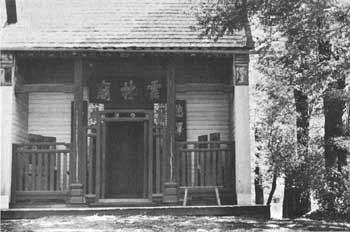 |
| Joss houses were places of worship for Chinese mineworkers. This one is at Weaverville, California. |
|
WOLFSKILL FARM SITE California |
|
| ||
William Wolfskill, a Kentuckian, formed a partnership in New Mexico with mountain man Ewing Young in the late 1820's. As a result, Wolfskill and George C. Young, leading a group of 20 men from Sante Fe to California in 1830-31, opened a new overland route that came to be called the Old Spanish Trail. Wolfskill settled permanently in California, where in 1838 he acquired a farm, later known as the Wolfskill Orchard Tract and located near the center of the present city of Los Angeles. He erected an adobe house and established the vineyards that were to make him rich and famous. A pioneer in the California wine industry, he helped supply the large market created by the gold rush. Also planting the first privately owned orange grove in California, he transplanted the trees from the abandoned gardens of San Gabriel Mission. After he died in 1866, his farm was subdivided as the city of Los Angeles expanded. In 1902 his adobe house was demolished. A portion of his farm is now occupied by the Los Angeles Union Railroad Station.
 |
 |
http://www.cr.nps.gov/history/online_books/prospector-cowhand-sodbuster/sited2.htm
Last Updated: 22-May-2005