


Survey of Historic Sites and Buildings
 |
AJO MINES Arizona |
|
| ||
In 1854 a group of Californians entered present southwestern Arizona, and found evidence of Mexican prospecting at the site of Ajo. They founded the Arizona Mining and Trading Company, the first company formed to exploit the mineral resources of Arizona, and began extracting copper ore. At first mule teams hauled the ore to San Diego, from where it moved by boat to Wales for smelting. Beginning about 1858 Yuma replaced San Diego as a shipping point, and barges carried the ore from there down the Colorado River to the Gulf of California. Because of low-grade ore, transportation difficulties, and protests by the Mexican Government that Ajo lay south of the Gadsden Purchase, the mines yielded only small profits. By 1861 the surface ore had played out, and the Ajo mines then lay idle for many years.
Early in the 20th century the St. Louis Copper Company found that the deposits were low-grade overburden that covered an enormous sulphide ore concentration of some 50 million tons. It went bankrupt, however, and another company unsuccessfully tried various methods of extracting the ore. In 1911 the Calumet and Arizona Mining Company took over the mines. After removing the overburden, it began the great Ajo open-pit copper mine. In 1931 the Phelps-Dodge company acquired the mine. Ajo today is a modern company town.
|
BISBEE Arizona |
|
| ||
Center of one of the richest and most extensive copper, gold, and silver mining districts in Arizona, Bisbee traces its origin to a discovery made by Hugh Jones in 1875 while he was prospecting in the Mule Mountains. Jones was looking for silver, and the copper he found so disappointed him that he did not even file a claim. In 1877 an Army scout, Jack Dunn, did so. Miners arrived, began operations, and founded the mining camp of Bisbee. Not until 1881, when Phelps-Dodge purchased much of the property, did large-scale mining get underway. Through mergers and litigation, the Copper Queen Consolidated Company, controlled by Phelps-Dodge, emerged as the dominant enterprise.
Bisbee today is a company town much like other Phelps-Dodge mining centers in Arizona, but it retains many of the traditions of its earlier days. Nearby abandoned mines recall its history, and producing mines emphasize the foundations of its present economy.
|
GLOBE Arizona |
|
| ||
A silver strike in the Pinal Mountains in 1876 led to a boom and the establishment of Globe, a mining camp in a nearly impenetrable area in the heart of Apache Indian country. Within a year the camp had a population of a thousand. The silver supply lasted only 4 years, but large deposits of copper ore insured the prosperity and growth of the town.
In 1881 the Old Dominion Company acquired the best ore fields in the area. Profitable large-scale operations, however, were delayed for two decades by the difficulty of freighting the ore 120 miles by ox team over rough mountain trails, infested with hostile Apaches, to the Southern Pacific Railroad terminal at Wilcox. When a branch line reached Globe in 1898, the Old Dominion Mine became one of the greatest copper mines in the world. Although it closed down in 1931, other mines in the area had opened. The town's economic foundations still rest upon the copper industry.
Modern Globe only remotely suggests its early history. A mile to the north, however, the concrete foundations, ruins of the smelter plant, and other remains give some idea of the extent of the Old Dominion.
 |
JEROME Arizona |
|
| ||
A famous and picturesque mining town, Jerome originated soon after 1876, when John Rufner and August McKinnon discovered rich copper ore nearby. Not until the Atlantic and Pacific Railroad reached the area in 1882, however, did extraction become profitable. That year the United Verde Copper Company was formed, with Eastern financial backing, to exploit the deposits. One of the New York financiers involved, Eugene Jerome, gave his name to the town that had sprung up on the side of Mingus Mountain. In 1885 a group led by William A. Clark, the famous Montana copper king, purchased the mines and profitably expanded them. In the early 1930's, when the price of copper was at a low, Phelps-Dodge bought out the United Verde. The demand for copper during World War II led to intensive mining that depleted the known deposits, and today Jerome is rapidly becoming a ghost town. Its rickety frame buildings, propped on stilts on the sheer slope of Mingus Mountain, recall the bygone era and are commemorated in Jerome State Historic Park, authorized in 1965.
NHL Designation: 07/04/61
|
KITCHEN (EL POTRERO) RANCH Arizona |
|
| ||
Situated on the Santa Cruz River just north of the Mexican border, this was the best known pioneer ranch in southern Arizona during the 1850's and 1860's. Pete Kitchen, a newcomer to Arizona, established it in 1854. The ranchhouse, as much a fort as a home, became a rallying point and refuge for would-be settlers and travelers during the bloody Apache wars. Kitchen engaged in truck gardening and stockraising, especially hogs, and hired many Mexicans and Opata Indians. Growing rich as a supplier of forts and stores from El Paso to Yuma, he was especially noted for his hams and bacon, considered to be the finest in the Southwest.
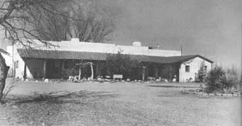 |
| From his ranch, El Potrero, located in the Santa Cruz Valley, early Arizona settler Pete Kitchen fought off Apaches, Mexican bandits, and American outlaws. He raised hay and vegetables, as well as large numbers of hogs. |
The original adobe building in which Kitchen lived until the 1880's is still intact. The present owner, Col. Gil Procter, has stabilized the walls and added a new roof. The more pretentious adobe ranchhouse that Kitchen later built is also still standing, and Procter uses it as a residence and museum. The museum is open to the public.
|
LA PAZ Arizona |
|
| ||
In 1858 prospectors struck gold in the rich sands along the Gila River just east of its junction with the Colorado. The first placer gold rush in Arizona ensued, and miners established the boomtown of Gila City. In 1864, after the placers washed out, they moved upstream to the site of La Paz, where gold had been previously discovered. The mining camp of La Paz sprang into existence overnight. Set back from the river about 2 miles to avoid inundation by floods, it soon consisted of about 6,000 people and was probably the most important settlement in Arizona at the time. During a period of 7 years, the sands of the Gila yielded $8 million worth of gold. As other mining camps sprang up in the Hassayampa Valley, La Paz became a supply base to which river boats brought cargoes and from which wagon trains hauled supplies to inland settlements. In 1870 the Gila cut a new channel, and the town's port days ended. Miners exhausted the placers, and Ehrenberg became the new distribution center. Few remains of the ghost town of La Paz are extant today.
|
McMILLENVILLE Arizona |
|
| ||
In 1874 Charles McMillen and his partner, "Dory" Harris, accidentally discovered silver ore at the site of McMillenville. Immediately staking a claim, they named their mine the Stonewall Jackson. They concentrated on removing the surface deposits, though they noticed pay streaks of silver underneath. Unaware of the great value of their claim, they sold it for $160,000 to a California company. Soon prospectors crowded in and formed the town of McMillenville. The lusty camp reached its peak in 1880, when it consisted of a jumble of tents and adobe saloons, gambling casinos, stores, and hotels. In 1882 the ore thinned out, and the following year many of the mines closed. Then, after an attack by the Cibecue Apaches, who resented the intrusion on the San Carlos Indian Reservation, the miners moved away. Ruins of adobe buildings may be seen today, but little remains of the mines or of the stamp mill.
|
MOWRY (PATAGONIA) MINE Arizona |
|
| ||
Discovered in 1857 by a Mexican herder, this was one of the most famous early silver mines in Arizona. Capt. R. S. Ewell and Col. J. W. Douglass, the first owners, sold it in 1859 to Sylvester Mowry, one of the Territory's pioneers, who prepared for large-scale production. By 1862 he was earning profits, but his outspoken Confederate sympathies led to his arrest by Gen. J. H. Carleton and internment at Fort Yuma. In 1871 Mowry died in London, where he had gone after his release to sell the mine. His heirs failed to maintain the title. In 1875 some Tucson promoters took the mine over and reworked it. In its lifetime the mine produced a total of $1,500,000 in silver and lead.
Many mining remnants are scattered over the mountainside near the ghost town of Mowry. Slag dumps, brick debris, and the remains of some building foundations, along with the rusting hulks of chimney stacks, boilers, and smelting equipment, may be seen. A group of abandoned buildings occupies a small valley below the mine. Some, of adobe and obviously repaired, probably date from Mowry's ownership; the others are of more recent construction.
|
RICH HILL DISTRICT Arizona |
|
| ||
A long, light-colored streak from the top of present Rich Hill to its base indicates the extent of mining activity in this district. Before the miners abandoned the district late in the 19th century, every bit of dirt had been overturned by gold seekers, who had progressed almost perpendicularly up the mountainside. Remains of miners' cabins may still be seen on the mountaintop. At the base of Rich Hill were three mining camps: Octave, Weaver, and Stanton. Octave was laid out in 1863. The Octave Mine, owned by eight men, began operations in 1893. Yielding millions of dollars worth of gold, it was active until World War II under various owners. Nothing remains of the camp today except stone foundations.
In 1862 prospectors discovered a small gold deposit on the surface at the east base of the mountain and rich placers of coarse gold at nearby Weaver Creek. A group of 100 Americans and 30 Mexicans removed $1 million worth of gold from the creek. By the 1890's the population of Weaver Camp was exclusively Mexican and the camp developed a reputation as a hangout for desperadoes. By 1896 the Mexicans had departed, and today only remains of burro corrals and the Boot Hill Cemetery may be seen.
Stanton Camp was formed at about the same time as Weaver. At its peak, the population was 2,000. Stanton gained a reputation similar to that of Weaver and was the scene of much violence. The remains are more substantial than those of Weaver or Octave. The site is privately owned.
|
SILVER KING MINE Arizona |
|
| ||
In 1872 two soldiers, who were helping to build a wagon road over the Pinal Mountains from Superior to Globe, discovered rocks of almost solid chloride of silver. No one exploited the deposit until 1875, when Charles Mason, Benjamin W. Regan, William H. Long, and Isaac Copeland rediscovered it. The four men organized the Silver King Mine and built stamp mills. A mining camp soon grew up. During the 1880's the mine yielded a seemingly inexhaustible flow of rich silver ore. During one 15-day period, 22 bars valued at $70,000 moved by mule from Pinal to the railroad at Casa Grande and then to San Francisco. For years the mine paid $25,000 a month in dividends, and its total output was $17 million. By 1886 the deposit began to thin out, and within 2 years all mining ceased.
The few buildings that are still standing house the lessees who work the mine on a small scale. Foundations and ruins of the mining camp and mine are scattered about the site.
|
SWILLING CANAL Arizona |
|
| ||
Ex-Confederate deserter and would-be mining promoter Jack Swilling probably started the conversion of the Salt River Valley from a desert into an agricultural area. Learning that prehistoric Indians had channeled the waters of the Salt and Gila Rivers into an extensive irrigation system, in 1867 he organized the Swilling Ditch Company at the mining town of Wickenburg. The company laid out a network of canals, which consisted of both new and renovated Indian ditches. Other companies moved into the area and helped build the irrigation system that formed the basic foundation of the Phoenix economy. Although no longer in use, the Swilling Canal may still be traced in places. It leaves the Salt River about a half mile east of the Joint Head Dam, near Pueblo Grande, and passes through Phoenix. The adobe building where Swilling organized his company is still standing in Wickenburg.
|
VULTURE MINE Arizona |
|
| ||
Henry Wickenburg, an Austrian refugee who had arrived in Arizona in the year 1862 and first prospected at Yuma and La Paz, founded this gold mine the following year. He named it the Vulture because he was led to it by a circling scavenger of that species. Building an arrastra, he found that he could not operate it and also work the mine, so he allowed others to mine while he crushed the ore for a set price. Unaware of the value of the high-grade ore his mine was yielding and charging far too little for his services, he was victimized by associates who stole more ore than they paid him to process. In 1865 he sold his rights in the mine to the Phillips Company of New York for $85,000, of which he received $20,000 as a downpayment. In a dispute with the company, he lost that sum and never received the balance due him. Although after 1865 the mine changed hands many times, it produced total profits of $17 million and was responsible for the establishment of the nearby town of Wickenburg, in 1866 one of the largest in Arizona.
|
WHITE HILLS Arizona |
|
| ||
The Indians knew of mineral deposits in the White Hills vicinity, but they carefully concealed the information from the white men until 1892, when a friendly Indian helped Henry Shaffer discover some silver deposits. Shaffer and two of his friends began working mines and soon were shipping out silver ore at a profit of $1,000 per ton. Many lessees arrived and formed the town of White Hills, which grew to a population of 1,500. The streets were undermined by 27 miles of tunnels, and 15 mines were located within a 1-mile radius. In 1894 R. I. Root formed the White Hills Mining Company, but the following year this company sold out to an English concern for $1,500,000. The new owners built a 40-stamp mill and piped water from a spring 7 miles away. The spring was never able to meet mining needs. Yet between 1892 and 1899 the various mines returned to their owners from $3 million to $12 million in profits. By 1900 the mill was operating only half time. After peak production was reached in 1898, the town declined. It is now a ghost town that haunts the foothills of the Cerbat Range.
 |
 |
http://www.cr.nps.gov/history/online_books/prospector-cowhand-sodbuster/sited1.htm
Last Updated: 22-May-2005