|
Oregon Caves Cultural Landscape Report |

|
ANALYSIS AND EVALUATION (continued)
VEGETATION
|
The monument straddles a natural transition zone between two mountainside forest types occurring in southwest Oregon. Mixed broadleaf and conifer forests grow below 4000 feet where Douglas-fir and pines produce a tall canopy. Above 4000 feet all conifer forests grow. Douglas-fir/oak type forest stands, characteristic of Merriam's Transition Life Zone, are found in the developed area. Additional dominant species include Oregon maple, Pacific madrone, Ponderosa and sugar pines, grand and white firs, Port Orford and incense cedars. Detailed records of landscape work at Oregon Caves are absent, making differentiation between historic and more recent plantings difficult. Some information about the historic design intent - massing and location - is recorded in the 1936 and 1938 master plans, Superintendent's monthly reports of CCC work, and historic photographs. Efforts were focused around the Chateau and plaza, although some planting occurred along the creek," exit trail and cave entrance. With less magnitude, naturalistic design practices employed at Crater Lake between 1922 and 1942, were implement ed at Oregon Caves. Plant materials native to the Siskiyou mountains were used as a feasible solution for plaza plantings. Transplants, "because they were the most suited to survive" were gathered outside the monument near the Oregon Caves Highway. [16] Bigleaf maple, Douglas-fir," and Port Orford cedar were carefully located to screen structures from view as well as provide shade and accent. Similarly, ferns were carefully massed below shrubs to enframe buildings and stone walls. Foundation plantings integrated structures near the cave entrance with the adjacent forest community. Major landscape work undertaken in 1962 by the Western Region, and after flood damage in 1964, concentrated on revegetating partially cleared areas. Twelve species of native plant materials were specified to "...maintain [and restore] a natural appearance for the developed area around the cave and parking facilities, [and to manage] plant and animal life...for visitor safety and enjoyment." [17] The steep slopes above the Chalet made replanting particularly problematic. Removal of Concession Cottages destroyed trees, impacting the appearance of the area. [18] Coppice growth has slightly obscured views south of the Ranger from the plaza and west of the Chateau. However, extant remnants of the historic period plantings are oceanspray and gooseberry found around the Chateau and plaza ponds, and fern species planted in the dry-laid stone walls. [19] |
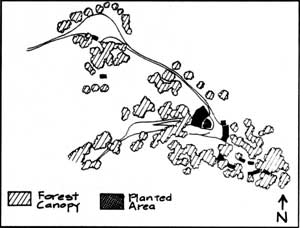 NPS Administration 1934-1941. 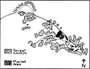 Concession Development 1909-1934. 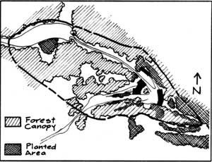 ORCA 1941-1990. |
 CHALET FRONT. |
 CHALET FRONT. |
| <<< Previous | <<< Contents >>> | Next >>> |
orca/clr/clr2o.htm
Last Updated: 05-Feb-2002