National Historical Park
Administrative History

|
Nez Perce National Historical Park Administrative History |
|
CHAPTER THREE:
LAND ACQUISITION AND PROTECTION
Land Acquisition for the Spalding Site
Land acquisition officially began with the transfer of Spalding State Park to the Park Service in a public ceremony on July 24, 1966. This area, with its shady arboretum and picnic grounds, its memorial to Henry and Eliza Spalding, and its pleasant stretch of riverfront, formed the nucleus of the Spalding site. It adjoins a cemetery and church used by Nez Perce tribal members.
After acquiring Spalding State Park, the Park Service still had an inadequate land base for protection of historic resources at Spalding. If the long-range goal was to restore the scene to its historical character, several dwellings of twentieth-century origin would have to be removed. Indeed more than a dozen houses and outbuildings extending along the county road from the Spalding post office west as far as the present-day maintenance building would have to be acquired and torn down. Thus, the most complicated, costly, and politically sensitive element of the whole land acquisition program involved the remaining lands that were to constitute the Spalding site.
Interior Department officials actually became involved in land acquisition at Spalding more than two years earlier, indeed before Congress enacted P.L. 89-19, by giving encouragement to a tribal proposal to acquire property in Spalding for later sale to the Park Service. The purpose of this informal arrangement was to prevent certain land owners from raising the price for their land once the park was authorized. In 1964, the tribe negotiated three land purchases in Spalding of the Watson, Evans, and Sampson brothers properties for a total investment of $53,299. In 1967, the Park Service agreed to purchase these tracts from the tribe for $66,000, allowing for seven percent per annum interest on the tribe's investment plus ten percent overhead and administrative costs. [148]
At the same time that the Park Service negotiated a land sale with the tribe, it made preliminary inquiries among local residents. While the Park Service was able to find a handful of willing sellers, other residents protested vehemently to Senator Frank Church. The senator, always wary of backlash from his constituents for his stances on environmental issues, suggested to NPS Director George Hartzog, Jr., that the Park Service might be trying to include more land in the Spalding site than Congress had intended. [149] Church recommended that the negotiations between the Park Service and land owners should be handled locally by the superintendent. This prompted a visit to Spalding by Hartzog in May 1967. After Hartzog's visit, Burns discussed the problem directly with Church and reported to the director, "I came away with the distinct feeling that the Senator will be satisfied with anything we do there — even though he did not come out and say it." [150]
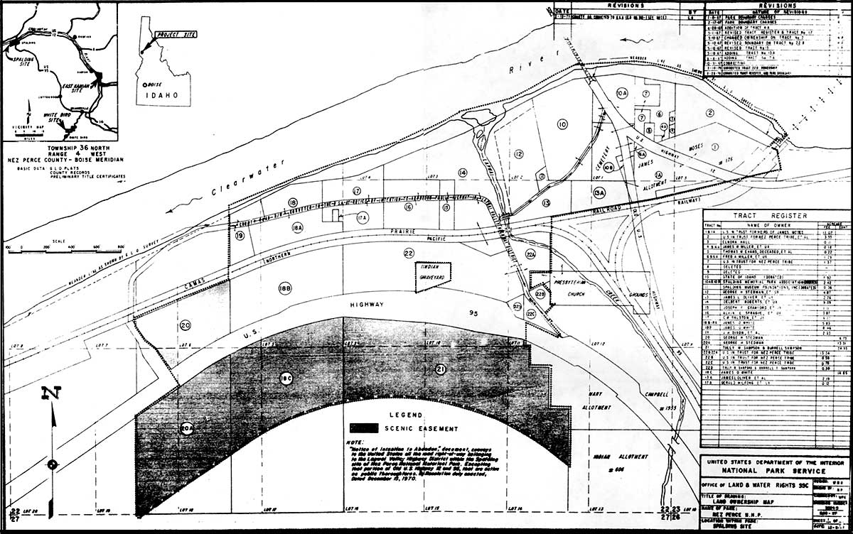
Figure 2. Land Ownership at Nez Perce National Historical Park
(NPS map.)
The Park Service determined to negotiate an acquisition package for the remaining landowners rather than purchase the tracts individually. Superintendent Burns, accompanying Inspector Clifford J. Harriman of the Park Service's central office in Washington, negotiated purchasing options with nine property owners as follows:
| Tract No. | Owner | Appraisal | Purchase Price# |
|---|---|---|---|
| # Purchase price includes sellers' moving and relocation expenses. Since 1983, the NPS has not had authority to pay more than the appraised value for real property. | |||
| 4 & 4A | James Miller | $8,500 | $14,950 |
| 6 & 6A | Fred Miller | 9,000 | 13,000 |
| 13 | James Oliver | 9,500 | 11,750 |
| 13A | Oliver Albright | 20,000 | 34,500 |
| 15 | Joe Crawford | 6,500 | 7,500 |
| 16 | Alvin Sprague | 9,600 | 11,200 |
| 17 | Chub Ralstin | 19,000 | 27,550 |
| 18A, B, & C | Jim White | 38,000 | 42,900 |
| 12-20 & 20A | George Stedman | 24,223 | 30,000 |
| TOTALS | 144,323 | $193,350 | |
There were four other landowners who had already settled with the Park Service:
| Tract No. | Owner | Appraisal | Purchase Price# |
|---|---|---|---|
| # Purchase price includes sellers' moving and relocation expenses. Since 1983, the NPS has not had authority to pay more than the appraised value for real property. | |||
| 3 | Elnora Hall | $4,000 | $5,000 |
| 17A | Gerald Wilfong | 8,750 | 9,900 |
| 21 | Tully Sampson | 20,280 | 22,500 |
| 2,22,22A, B, C | Nez Perce Tribe | 42,750 | 66,000 |
| TOTALS | 75,780 | 103,400 | |
and three landowners who had made offers:
| Tract No. | Owner | Appraisal | Purchase Price# |
|---|---|---|---|
| # Purchase price includes sellers' moving and relocation expenses. Since 1983, the NPS has not had authority to pay more than the appraised value for real property. | |||
| 5 | Thomas Evans | 3,000 | 6,000 |
| 14, 14A, 14B | Del Roberts | 24,000 | 30,000 |
| 19 | J.H. Dixon | 11,500 | 15,000 |
| TOTALS | 38,500 | 51,000 | |
In addition, the NPS prepared to bring condemnation proceedings against two other land owners for Tracts 1, 1A, and 22D unless they joined in the overall settlement. This brought the total cost of land acquisition for the Spalding unit to $358,750. The total was higher than anticipated, but Harrison recommended that the Park Service accept the package because many of the property owners were elderly and were experiencing difficulty relocating and had already inspired local sympathy. The negotiations, Harrison further explained, had been long and difficult and the alternative of bringing condemnation proceedings would be costly. Assistant Director Ed Hummel authorized the chief of the Office of Land and Water Rights, Thomas Kornelis, to accept the options on all tracts in the Spalding area. [151]
By December 1968, the land acquisition program for the Spalding site was nearly complete. Three significant land issues remained which would present some difficulties for years to come. These were the Camas Prairie Railroad right-of-way, the Lapwai Mission Cemetery, and the Spalding viaduct. The Camas Prairie Railroad went right through the Spalding site, with the former state park being situated on one side and the old Presbyterian church on the other. Freight trains ran fairly regularly along this railroad; today they run daily, mostly carrying logs. The trains posed a safety hazard as well as a problem of aesthetics. A Lewiston-based group now and then raised the possibility of operating steam-powered excursion trains between Lewiston and the historical park, a prospect that the Park Service viewed with disfavor. Instead, the Park Service planned to seek a scenic easement over this railroad right-of-way to prevent commercial development. The plan, however, was never carried out. [152]
The Lapwai Mission Cemetery had historic value. It contained the grave stones of Henry and Eliza Spalding and many mission Nez Perce parishioners. It abutted the arboretum in the former Spalding State Park. The Nez Perce Tribe owned the cemetery and still used it, while the Board of Trustees of the Spalding Presbyterian Church managed it. Prior to 1966, the state of Idaho had a verbal agreement with the Board of Trustees to maintain the cemetery along with the state park. After the transfer of the state park to the Park Service, Superintendent Burns provided for the cost of maintenance (mainly mowing and watering) from the park's budget. In 1971, Superintendent Williams formalized this arrangement in a memorandum of agreement between the NPS and the tribe. Thus, all land protection issues involving the cemetery — gating the road at night, discouraging inappropriate recreational use of the cemetery grounds, improving the sprinkler system — required cooperation between the park administration and the Board of Trustees of the Spalding Presbyterian Church. [153]
In 1979, Superintendent Morris proposed a land exchange with the tribe that would allow for expansion of the cemetery to the south and consolidate the park's holdings north of it (Figure 3). At that time the former Blue Lantern Motel, which extended onto the Park Service's 1.27-acre parcel, was still in use as park administrative headquarters. Under Superintendent Morris' proposal the former Blue Lantern would be vacated and the building razed prior to the land exchange. NPTEC approved the plan but the church's Board of Trustees claimed that the tribal land involved in the exchange actually belonged to the Spalding Presbyterian Church. This delayed the land exchange for several years until the tribe was able to obtain clear title to that tract. The transfer was finally accomplished in 1991. [154]
The third unresolved land issue in Spalding involved the Spalding viaduct, or more broadly, the evolving commercial highway pattern in the area. As proponents of Nez Perce National Historical Park had emphasized all along, two interstate highways converged at Spalding, making that place a natural "gateway" for orienting tourists to Nez Perce country. Yet the highway junction also threatened to overwhelm Spalding's historical character.
The highway traffic pattern around Spalding went through three major changes, each involving the construction or abandonment of a different bridge (Figure 4). When the park was first proposed, all traffic through the area used the Old Spalding Bridge across the Clearwater River. Dating from the 1920s, this highway bridge joined the south bank of the river less than one hundred yards from the historic mission site. The first change in this highway traffic pattern occurred with the completion of the New Spalding Bridge one and a half miles west of Spalding. Traffic between U.S. 95 and Lewiston now bypassed Spalding, whisking past the village on a broad 55 m.p.h. curve that rounded the hillside between Lapwai Creek and the Clearwater River. The new bridge opened shortly before Nez Perce National Historical Park was authorized.
The second change came in the 1970s with the completion of the Arrow Bridge, a little more than two miles east of Spalding, and the removal of the Old Spalding Bridge. Now all traffic on U.S. 12 bypassed Spalding on the opposite side of the Clearwater River. Even if traffic now moved past the site at greater speeds, these changes were probably good from the standpoint of protecting the historic resources and improving the park setting. But some traffic between U.S. 95 and points east still went through the site, because savvy motorists knew that they could shave about three miles off their trip by taking the old U.S. 12 from Spalding along the south side of the Clearwater River to Arrow Junction.
The third change in the highway traffic pattern came with the closure of the Spalding viaduct in 1986 when the state highway department declared it unsafe. The closure deflected all traffic that was using old U.S. 12 onto the short section of road past the picnic area. Superintendent Weaver was faced with the unacceptable situation of having semi-trucks and numerous other vehicles driving directly through the Spalding unit. Not only did it harm the park's ambiance, but the road itself was crumbling under this unprecedented usage. After considerable local public debate on the situation, Weaver decided to close the park road to through traffic in 1988. Signs were posted at Arrow Junction to warn motorists that old U.S. 12 now ended at the Spalding viaduct. Frustrated motorists who missed the signs kept breaking down the Park Service's barrier when they got to Spalding. Finally Weaver put up a heavy pipe gate. Frustration with the road closure gradually abated, leaving the highway traffic pattern around Spalding more favorable than it had been in seventy years from the standpoint of the historic resources and providing a parklike ambiance. The old, abandoned viaduct still stands, and continues to be a major visual intrusion on the historic scene. [155]

Figure 3. Historical Map of Land Exchange, Spalding, 1991.
(National Park Service map, no date.)

Figure 4. Historical Map of Highway System at Spalding, 1971.
(State of Idaho Department of Highways Map.)
Chapter Three