|
Navajo
Administrative History |

|
APPENDIX 4: PERTINENT LEGISLATION
A. Monument proclamation 1909
B. Boundary adjustment 1912
C. Memorandum of Agreement 1962
D. Maps
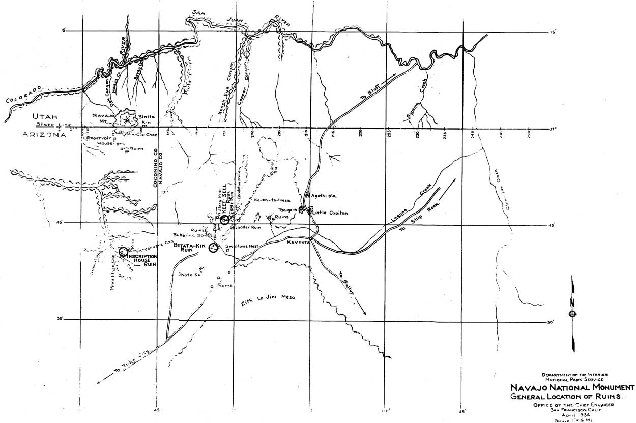
NAVAJO NATIONAL MONUMENT,
ARIZONA.By the President of the United States of America,
A Proclamation
WHEREAS, a number of prehistoric cliff dwellings and pueblo ruins, situated within the Navajo Indian Reservation, Arizona, and which are new to science and wholly unexplored, and because of their isolation and size are of the very greatest ethnological, scientific and educational interest, and it appears that the public interest would be promoted by reserving these extraordinary ruins of an unknown people, with as much land as may be necessary for the proper protection thereof:
Now, therefore, I, WILLIAM H. TAFT, President of the United States of America, by virtue of the power in me vested by Section two of the Act of Congress approved June 8, 1906, entitled: "An Act for the Preservation of American Antiquities", do hereby set aside as the Navajo National Monument all prehistoric cliff dwellings, pueblo and other ruins and relics of prehistoric peoples, situated upon the Navajo Indian Reservation, Arizona, between the parallels of latitude thirty-six degrees thirty minutes North, and thirty-seven degrees North, and between longitude one hundred and ten degrees West and one hundred and ten degrees forty-five minutes West from Greenwich, more particularly located along the arroyas, canyons and their tributaries, near the sources of and draining into Laguna Creek, embracing the Bubbling Spring group, along Navajo Creek and along Moonlight and Tsagt-at-sosa canyons, together with forty acres of land upon which each ruin is located, in square form, the side lines running north and south and east and west, equidistant from the respective centers of said ruins. The diagram herto attached and made a part of this proclamation shows the approximate locations of these ruins only.
Warning is hereby expressly given to all unauthorized persons not to appropriate, excavate, injure or destroy any of the ruins or relics hereby declared to be a National Monument, or to locate or settle upon any of the lands reserved and made a part of said Monument by this proclamation.
IN WITNESS WHEREOF, I have hereunto set my hand and caused the seal of the United States to be affixed.
[SEAL]Done at the City of Washington, this 20th day of March in the year of our Lord one thousand nine hundred and nine, and of the Independence of the United States the one hundred and thirty-third.
WM H TAFT
By the President:
P C Knox
Secretary of State.
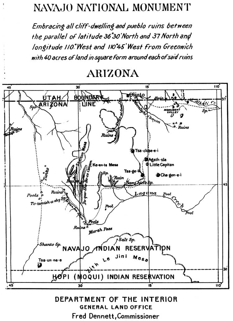
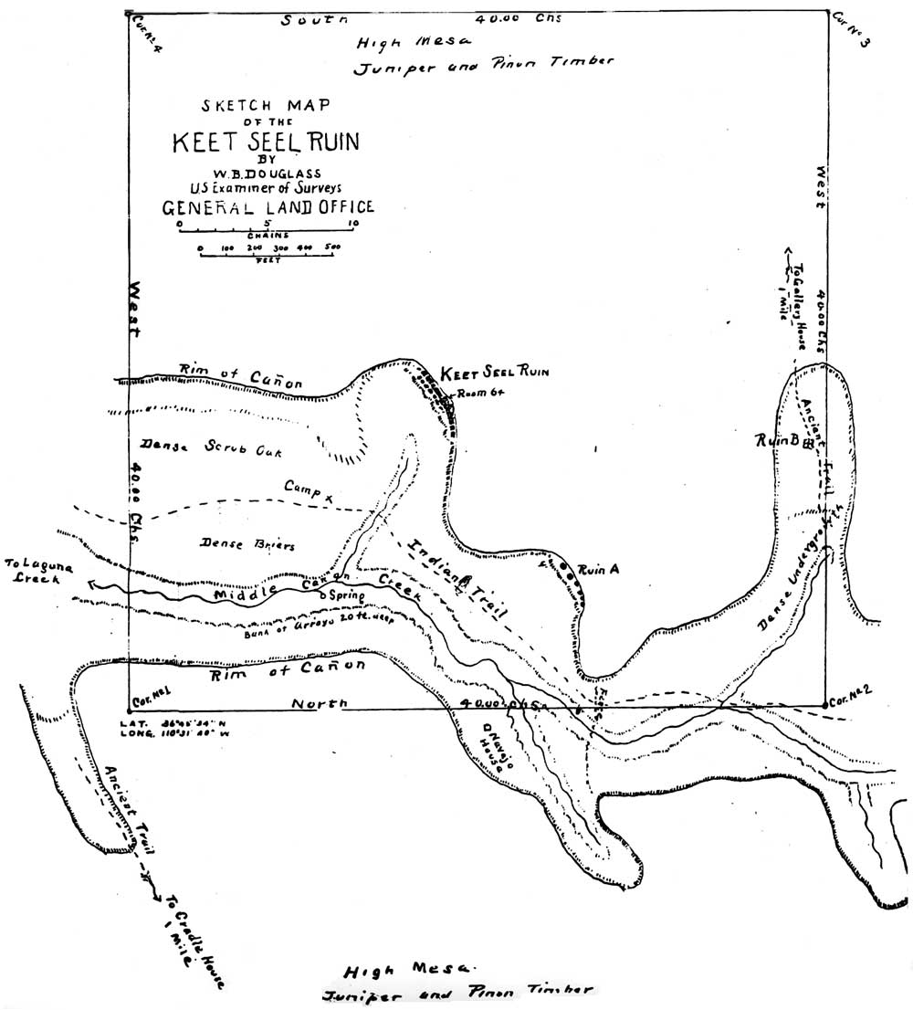
(click on image for a larger size)
SECOND PROCLAMATION
NAVAJO NATIONAL MONUMENT
ARIZONA.By the President of the United States of America,
A Proclamation
WHEREAS, the Navajo National Monument, Arizona, created by proclamation dated March 20, 1909, after careful examination and survey of the prehistoric cliff dwelling pueblo ruins, has been found to reserve a much larger tract of land than is necessary for the protection of such of the ruins as should be reserved, and therefore the same should be reduced in area to conform to the requirements of the act authorizing the creation of National Monuments:
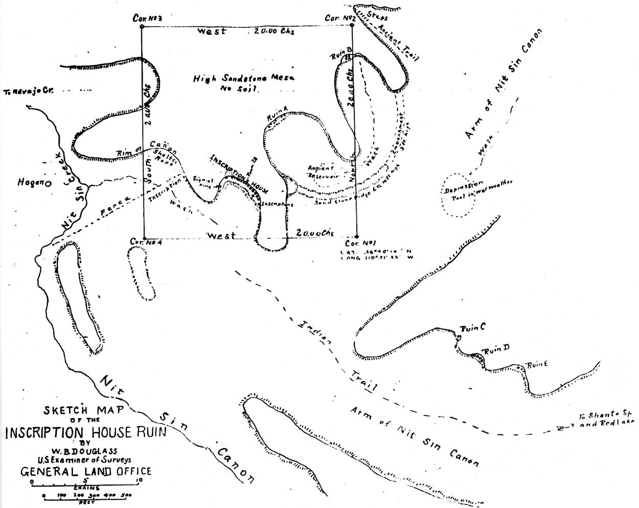
Now, therefore, I, WILLIAM H. TAFT, President of the United States of America, by virtue of the power in me vested by Section two of the act of Congress entitled, "An Act for the Preservation of American Antiquities", approved June 8, 906, do hereby set aside and reserve, subject to any valid existing rights, as the Navajo National Monument within the Navajo Indian Reservation, two tracts of land containing one hundred and sixty acres each, and within which are situated prehistoric ruins known as "Betata Kin" and "Keet Seel", respectively, and one tract of land, containing forty acres, and within which is situated a prehistoric ruin known as "Inscription House". The approximate location of these tracts is shown upon the diagram which is hereto attached and made a part of this proclamation.
Warning is hereby expressly given to all unauthorized persons not to appropriate, excavate, injure or destroy any of the ruins or relics hereby declared to be a National Monument, or to locate or settle upon any of the lands reserved and made a part of this Monument by this proclamation.
IN WITNESS WHEREOF, I have hereunto set my hand and caused the seal of the United States to be affixed.
[SEAL]Done at the City of Washington, this 14th day of March in the year of our Lord one thousand nine hundred and twelve, and of the Independence of the United States the one hundred and thirty-sixth.
WM H TAFT
By the President:
Huntington Wilson
Acting Secretary of State.[No. 1186.]
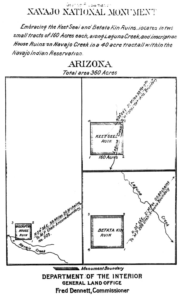
(click on image for an enlargement in a new window)
C. Memorandum of Agreement 1962
|
ORGANIZATION |
VOLUME Part 10 Chapter 1 Section 5.7 Page a |
|
MEMORANDUM OF AGREEMENT OF MAY 8, 1962
BETWEEN THE NAVAJO TRIBE, BUREAU OF INDIAN AFFAIRS, AND NATIONAL PARK SERVICE RELATING TO THE RECREATIONAL DEVELOPMENT OF THE NAVAJO NATIONAL MONUMENT WHEREAS, it is in the public interest to facilitate recreational development of The Navajo National Monument through the construction of administrative, residential, and related facilities on lands adjacent to the existing Betatakin Section of Navajo National Monument and to construct and maintain an access road to the Betatakin Section. In order to accomplish these purposes, a cooperative agreement must be entered into between the Navajo Tribe, the Bureau of Indian Affairs, and the National Park Service. WHEREAS, under the Act of August 7, 1946 (Public Law 633, 79th Congress) appropriations for the National Park Service are authorized for the administration, protection, improvement and maintenance of areas devoted to recreational use pursuant to cooperative agreements under the jurisdiction of other agencies of the government. WHEREAS, agreement has been reached among The Navajo Tribe, the Bureau of Indian Affairs, and National Park Service, specifying that legislation will be sought to authorize the inclusion of ceertain lands within the boundaries of other agencies of the government. WHEREAS, agreement has been reached among The Navajo Tribe, the Bureau of Indian Affairs, and National Park Service, specifying that legislation will be sought to authorize the inclusion of certain lands within the boundaries of The Navajo Reservation, and providing for the granting of a right-of-way for a new access road to Navajo National Monument. NOW THEREFORE, The Navajo Tribe, the Bureau of Indian Affairs and National Park Service, do hereby mutally agree as follows: 1. This agreement will be regarded as an interim arrangement to permit the National Park Service to proceed with programmed development of Navajo National Monument pending the enactment of legislation providing a permanent basis and authority for such development. | |
|
ORGANIZATION |
VOLUME Part 10 Chapter 1 Section 5.7 Page b |
|
2. This agreement shall apply to the lands within the proposed road right-of-way as shown on the attached drawing NM-NAV-31001/ and to the lands indicated within the proposed boundary on the attached drawing NM-NAV-71021/ and which are further described as follows: Beginning at Corner No. 4 of the existing 160 acre tract set aside as the Betatakin Section of Navajo National Monument, thence north along the west boundary of said area a distance of 1,320 feet, thence west a distance of 1,320 feet, thence south a distance of 3,960 feet, thence east a distance of 2,640 feet, thence north a distance of 1,320 feet, thence east a distance of 1,320 feet, thence north a distance of 1,320 feet to Corner No. 1 of the existing Betatakin Section of Navajo National Monument, thence west along the south boundary of said area of Corner No. 4, the Point of Beginning, enclosing a tract of land of 240 acres, more or less. 3. While it is understood that the current status of the above described lands in regard to The Navajo Tribe and the Bureau of Indian Affairs shall remain unchanged, and that such lands shall remain subject to all laws applicable thereto, it is agreed by The Navajo Tribe and Bureau of Indian Affairs that the above described lands will be devoted primarily to recreational use in connection with the operation of Navajo National Monument. 4. Subject to the availability of funds, the National Park Service may and will undertake the development, construction and maintenance of facilities on the lands referred to in Item 2 above, needed in the proper management of Navajo National Monument as a unit of the National Park System. 5. The National Park Service will assume responsibility for the park facilities of the aforementioned lands and improvements incident thereto. 6. This agreement shall become effective upon approval by the Secretary of the Interior, and shall remain in force and effect until terminated by mutual agreement or until enactment by Congress of legislation inconsistent herewith. | |
|
ORGANIZATION |
VOLUME Part 10 Chapter 1 Section 5.7 Page c |
|
7. The National Park Service agrees that in consideration for the execution of this agreement by The Navajo Tribe that it will assist in every manner possible in supporting legislation providing for the conveyance to The Navajo Tribe by the Bureau of Reclamation of a certain area at Antelope Creek, Coconino County, State of Arizona, to be utilized by The Navajo Tribe as a recreational facility. 8. The Navajo Tribe reserves the right, during the term of this agreement, to operate an arts and crafts enterprise with Navajo National Monument, notwithstanding the Maintenance of facilities thereon by the National Park Service. | |
| SUBMITTED: | |
| Date: May 29, 1961 | (SGD) Paul Jones THE NAVAJO TRIBE |
| Date: Sep 21, 1961 | (SGD) James F. Canan BUREAU OF INDIAN AFFAIRS |
| Date: Dec 12, 1961 | (SGD) Thomas J. Allen NATIONAL PARK SERVICE |
| RECOMMENDED: | |
| (SGD) John O. Crow ACTING COMMISSIONER, BUREAU OF INDIAN AFFAIRS |
May 8, 1962 Date |
| (SGD) Thomas J. Allen REGIONAL DIRECTOR, NATIONAL PARK SERVICE |
January 16, 1962 Date |
| (SGD) Conrad L. Wirth DIRECTOR, NATIONAL PARK SERVICE |
May 8, 1962 Date |
APPROVED: By Secretary Udall by his memorandum of January 8, 1962 to Director, National Park Service.
| |
|
Date 1/ On file in the Washington Office. Release No. 29 |
SECRETARY OF THE INTERIOR
|
(click on image for an enlargement in a new window)
(click on image for an enlargement in a new window)
(click on image for an enlargement in a new window)
| <<< Previous | <<< Contents >>> | Next >>> |
nava/adhi/adhiaa4.htm
Last Updated: 28-Aug-2006