Environment, Prehistory & Archaeology of Mount Rainier National Park, Washington
Greg C. Burtchard
Chapter 1:
INTRODUCTION TO THE MOUNT RAINIER PROJECT
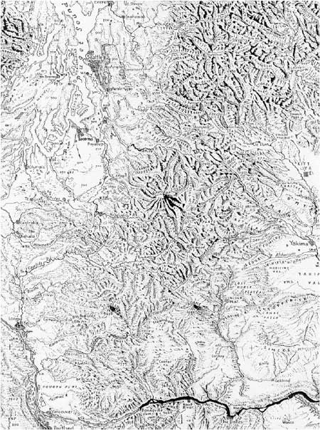
The mountain locally known as Tahoma [1] was renamed Mount Rainier by George Vancouver. It is the highest and most massive of the stratovolcanos that form the eastern spine of the 700 mile long Cascade range from Mt. Giribaldi in southern British Columbia to Mt. Lassen in northern California. For at least the last 75,000 years, Rainier has loomed above the surrounding western Cascade peaks, dominating the landscape from the Puget Trough to the Cowlitz River valley on the west, and from the Kittitas to Yakama valleys on the east (Figure 1.1).

|
| Figure 1.1 Mount Rainier and the Southern to Northern Washington Cascades (after Raisz 1965; courtesy Raisz Landform Maps, Melrose, MA) |
Beginning with its European discovery in 1792 and continuing through the 1800s, Mount Rainier figured prominently in the notes of explorers, military observers, adventurers and settlers. Early exploration and climbing efforts encountered, and frequently were guided by, various ethnically distinct Indian groups already familiar with the mountain's lower to mid-elevation landforms. To the Europeans, Mount Rainier was regarded variously as a feature of monumental natural beauty, an irksome travel barrier, and a peak to be conquered for personal satisfaction and gain. The mountain probably represented these things to Indian people as well, but with fundamental differences. To indigenous populations, Tahoma's forest and riverine approaches and mid to upper elevation landscapes also were recognized as places where plant and animal resources could be acquired–places to be visited seasonally as part of the normal course of life in and around the southern Washington Cascades. [2] As will be seen, there is ample reason to believe that such use extended for thousands of years into the prehistoric past as well.
Mount Rainier and its immediately surrounding terrain was incorporated into the National Park system in 1899. The Park was founded primarily to preserve the unique scenic and geological character of the mountain and its associated glaciers, alpine landforms, fringing forested slopes and river valleys. Unrelated to the primary purpose of its founding, little attention was paid to Rainier's historic and more distant prehistoric past. Despite historic and ethnographic accounts of native use, and reports of prehistoric artifacts, until recently there existed a sense that "...Indians never lived on the mountain and seldom hunted there..." (Schmoe 1967:128; cf., Bohannon 1974) and, hence, a belief that archaeological remains–particularly prehistoric remains–were poorly represented within Park boundaries. Now, a growing body of evidence suggests that Mount Rainier's subalpine and alpine landscapes were used throughout much of the Holocene as a part of seasonal plant and animal foraging strategies common to the Cascades generally. This volume and the 1995 Reconnaissance Data volume (Burtchard and Hamilton 1998), bring together extant information and new inventory data relevant to prehistoric use of the mountain in order to improve our understanding of Tahoma's place in long-term human use of the broader region; clarify basic patterns in the archaeological record of that use; and develop options to better interpret, protect and research Mount Rainier's archaeological heritage.
PREVIOUS ARCHAEOLOGY
Prior to completion of the present project, information regarding early historic and prehistoric use of the Park was limited to brief glimpses in historic and ethnographic accounts, to reported artifact finds and speculation by interested Park employees (e.g., Schmoe 1925 and 1967; Dalle-Molle 1971 and 1988; and Dalle-Molle and Dalle-Molle 1978), and to several small-scale archaeological survey and test efforts. The first systematic sample inventory of the Park was a combined ethnographicarchaeological effort conducted in 1963 under the joint direction of Allan Smith and Richard Daugherty of Washington State University's Department of Anthropology. Smith's (1964) meticulous ethnographic account documented seasonal use by Indian groups on all sides of the mountain, and directed particular attention to hunting and gathering in subalpine parkland and alpine landscapes. Unfortunately, Daugherty's (1963) follow-up survey emphasized river valleys and documented only two archaeological localities. One of these, Fryingpan Rockshelter (45PI43), was test excavated the following year, producing artifact and faunal remains related to hunting and short-term residence about 1,000 or more years ago (Rice 1965). [3]
Subsequent archaeological efforts and informal reports completed during the 1970s and 1980s led to formal documentation of several additional sites. Two of these, 45PI407 at Frozen Lake and talus boulder rockshelter site 45PI303 in Berkeley Park (Bergland 1986, 1988), demonstrated prehistoric human presence in alpine tundra and subalpine parkland habitats respectively. Surface exposed artifacts at Frozen Lake suggested hunting, butchering and tool making activities. Test excavations at the Berkeley rockshelters produced hunting remains dated to between 2,000 and 1,000 years ago with possible reuse about 300 years ago and in historic times. While not investigated in detail, a third site near Tipsoo Lakes on the east-central Park boundary (45PI406) also contained scattered lithic remains in subalpine environmental context.
By the close of the 1980s only the four localities noted above had been formally documented as bona fide prehistoric sites. However, at least 26 additional prehistoric finds had been reported by various Park employees and interested individuals. Information about them was widely scattered. A few reports were accompanied by artifacts turned in to Park headquarters in Longmire. Other artifacts disappeared into private collections. Some reported finds were accompanied by maps, many were not. Clearly, however, a picture of substantially greater prehistoric use of Park landscapes than heretofore supposed was beginning to emerge.
The present project has its roots in 1990. That year, a Park Service contract was issued to consolidate existing Mount Rainier cultural resource records, verify reported site locations in the field, and conduct limited new survey. During that project, four additional prehistoric sites were recorded, a draft basemap and associated site report information assembled, and an introductory overview prepared (McClure 1990). Cultural remains exposed in a borrow pit cut-bank on the south flank of Sunrise Ridge (45PI408) provided the earliest firm evidence for human use of the Park presently available–chipped stone debitage eroding from sediments sandwiched between circa 3,500 and 2,300 volcanic deposits. Even prior to formal testing, visible remains underscored the notion that prehistoric use of the mountain extended at least to the mid-Holocene, and probably beyond.
Unfortunately, the project begun in 1990 was not completed. Even so, enough work was done to clarify further a picture of Mount Rainier archaeology that had been emerging slowly since Schmoe's observations in the 1920s. That is, McClure's results further eroded the view that Park landscapes were little used in the prehistoric past. Rather, accumulating evidence suggested that the mountain preserved at least a moderate density of prehistoric remains, and that these remains appeared to be located predominantly in subalpine to alpine habitats as emphasized by Smith's Indian and ethnohistoric sources 27 years before.
THE PRESENT PROJECT
The present overview and research design project was intended to expand and complete the work begun in 1990. The contract to do so was awarded to the International Archaeological Research Institute, Inc. (IARII) in 1994 (Park Service Contract 1443-CX9000-93-020, Task 5) and implemented in the summer of 1995. We pursued four specific project goals.
1. Prepare an archaeological overview for Mount Rainier National Park emphasizing environmental structure, archaeological and ethnographic investigations in and adjacent to the Park, and discussing the relationship between the montane environment and prehistoric landuse practices;
2. Develop a research design including stratification of the Park into meaningful research and management units, a predictive prehistoric site distribution model, and continuing management and research recommendations;
3. Complete new archeological sample survey structured to provide a more complete view of the Park's prehistoric archaeological record; and
4. Prepare archaeological base maps and supporting site data for prehistoric localities documented within Mount Rainier National Park boundaries.
Six weeks of fieldwork were completed in late summer 1995. During the project, the author and Stephen Hamilton were charged with 1) consolidating and investigating as many previously identified finds as practical, and 2) expanding the database through new reconnaissance survey structured to widely sample Park landforms and environmental zones. These efforts resulted in formal documentation of 14 archaeological sites (12 prehistoric and 2 historic) and 18 isolated finds for which formal site designation was not warranted, pending subsurface reconnaissance techniques. Combined new and previous surveys brought the number of formally documented prehistoric sites and isolated finds to 38. Formal documentation for each of these, and the two newly documented historic sites, is included in the separately bound 1995 Reconnaissance Data volume (Burtchard and Hamilton 1998).
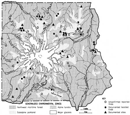
In addition to formally documented prehistoric places, at the close of 1995 the Park had 24 unconfirmed prehistoric or early historic localities for which location and artifact information are sufficient to warrant confirmation survey. In sum, the total formally documented and solid, but unconfirmed, sites and isolates stood at 62. Figure 1.2 shows the presently known distribution of prehistoric localities in relation to the Park's general environmental zones. Undoubtedly, by the time this report is read, the number will have increased further.
The salient point to be taken in this brief introduction is that the Park's prehistoric archeological record is robust, represented on all sides of the mountain, and biased toward subalpine to alpine habitats and the subalpine/forest ecotone. A complete account of the Park's archaeological history and summary results of the present effort is presented in Chapters 3 and 4 of this report. Appendix A lists all reported prehistoric sites and isolated finds in Mount Rainier National Park through 1995. Detailed site-specific description of 1995 survey results with map, verbal and photographic documentation of the Park's prehistoric (and two historic) localities is the primary focus of the separately bound 1995 Reconnaissance Data companion volume (Burtchard and Hamilton 1998). In essence, that volume addresses project goals 3 and 4 above. It is intended for professional audiences requiring detailed site specific information for management or research purposes.

|
| Figure 1.2 Sites, Isolates and Reported Prehistoric Finds in Mount Rainier National Park |
The second half of the report emphasizes the manner in which the Park's prehistoric record relates to larger environmental, archaeological and land-use issues (goals 1 and 2 above). The primary intent is to describe and model long-term environmental and human land-use patterns, evaluate the extent to which these patterns are consistent with the Park's known archaeological record, and use combined results as a foundation for continuing inventory and data recovery recommendations.
The present report is organized into six chapters. Chapter 2 describes Mount Rainier's physiography, climate, floral and faunal patterns; emphasizing elements considered most critical for attracting and conditioning prehistoric human use. Chapter 3 is divided into two sections. The first, written by Rick McClure, provides archaeological background of the southern Washington Cascades in the near vicinity of Mount Rainier National Park. The second section summarizes cultural resource efforts that took place in the Park prior to the present reconnaissance. Initial sections of Chapter 4 describe current reconnaissance procedures and summarize results. The third section of that chapter, co-authored by Steve Hamilton, uses field analyzed lithic data to characterize assemblage and site variability on Mount Rainier. The fourth section summarizes relationships between specific environmental and landform characteristics and prehistoric site density. Chapter 5 focuses on land-use patterns. Its first section is a preliminary model of site types and distribution patterns in the Park. The second part draws on environmental data, and population and evolutionary ecology to develop an intensification model of changing subsistence and settlement patterns for Mount Rainier and the southern Washington Cascades. Chapter 6 pulls together what is known about Mount Rainier archaeology to develop long range interpretive, protection and research recommendations. Appendices provide supporting detail for information included in the body of the report. It is hoped that combined results will improve our understanding of the manner in which the montane environment has been used over long stretches of time, and in so doing will broaden our appreciation of Tahoma's multi-faceted character.
| <<< Previous | <<< Contents >>> | Next >>> |