|
Lincoln Boyhood
Historic Resource Study |

|
CHAPTER VIII:
Post-Lincoln History of Property
As previously noted, the Lincolns sold their original quarter-section farmstead to Charles Grigsby in February, 1830, for the sum of $125. Grigsby owned the property for five years, then sold it to Edley Brown in December, 1835. Ownership changed hands twice more in the next three years, from Brown to James Sally in 1837, and from Sally to Joseph Gentry in 1838. Gentry retained the property until 1850, then sold the north forty acres to Elijah Winkler. Three years later, Gentry sold the south forty acres to William Oskins. Within six years, the latter parcel again was acquired by the Gentry family when James Gentry, Jr., purchased it from Oskins. [200] Throughout these exchanges of ownership, it is presumed that the land continued to be cultivated or at least used for pasturage. No one is believed to have lived at the Lincoln farm, however, as the 1817 cabin had been removed by 1865 and later descriptions of the 1829 house indicate it had been left to deteriorate for a number of years.
LINCOLN CITY
Like much of the rest of the country, Indiana experienced an astonishing burst of railroad construction during the middle decades of the nineteenth century. The majority of the state's rail lines traversed central and northern Indiana, particularly around the growing industrial centers of Indianapolis and Gary. In southcentral Indiana, only a few rail lines existed by 1880, including the Lake Erie, Evansville & Southwestern, the Evansville & Terre Haute, and the Louisville, New Albany & Chicago. In Spencer County, the Board of Commissioners accepted a petition signed by more than 100 local residents who requested an election on the issue of local aid to the Rockport & Northern Central Railway Company for construction of a route through the county. Spencer County voters approved provision of 2 percent of the county's 1868 tax levy (a total of $97,891) for the project. Residents of neighboring DuBois County approved a similar levy and construction on the road bed between Rockport and Jasper began in 1869. Around 1872, the Rockport & Northern Central Railway and the Cincinnati & Southwestern Railway companies consolidated to form the Cincinnati, Rockport & Southwestern Railway Company. [201] Financial shortfalls plagued the company and halted construction for a time. Eventually, the Rockport Banking Company came to the struggling company's aid, agreeing to advance $10,000 for each five miles of track. Construction resumed at a more rapid pace and in May, 1874, the first excursion train left Rockport bound for Coal Hill Station at the Spencer/DuBois county line. Construction of the rail line continued at a fitful pace through the late 1870s, finally reaching Jasper in February, 1879. A few months later, the Cincinnati, Rockport & Southwestern Railway sold its assets to the Evansville Local Trade Railway Company. In 1881, this consolidated company became the Evansville, Rockport & Eastern Railway Company, but within the year it had been absorbed by the Louisville, New Albany & St. Louis Railway Company, which in turn was soon renamed the Louisville, Evansville & St. Louis Company. Such convoluted reorganizations and consolidations were typical of railroad companies during this period. The various mergers meant that the short line from Rockport to Jasper ultimately became connected to a much larger rail system that extended from Louisville to St. Louis. [202]
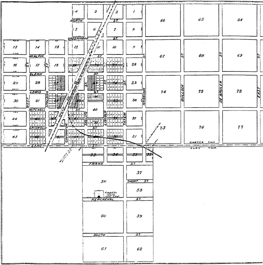
Construction of railroad routes almost invariably prompted land speculation and development along the proposed routes. The rail line through Spencer County was no exception. In 1871, James Gentry sold the former Lincoln farmstead to John Shillito, Henry Lewis, Robert Mitchell, and Charles West. These four speculators from Cincinnati intended to plat a community along the Cincinnati, Rockport & Southwestern's new line (Figure 19). The post office originally was called Kercheval, undoubtedly after R. T. Kercheval, who had rescued the company in 1874. By 1881, the town's name had been changed to Lincoln City, in recognition of its proximity to the old Lincoln farm. The community had several stores, including those maintained by James Gentry, Jr., William Gaines, W. J. Chinn, and Walter Howard. S. N. Hilt operated a blacksmith shop, while T. N. Robinson kept a hotel. The village also had a saloon and train station. [203]

|
| Figure 19: 1879 Map of Lincoln City (Griffing, 1879) (click on image for an enlargement in a new window) |
The community prospered for a time, with as many as twelve passenger trains passing through on a daily basis. Three rounds trips were made to Cannelton and Rockport, and six to Evansville. The railroad company constructed a fourteen-acre lake to furnish a water supply and the site also was used for recreational activities, but few traces remained of the forest that had covered much of the area when the Lincolns arrived in 1816. At its height, Lincoln City supported two hotels, four stores, two restaurants, a livery barn, and a tavern. In 1904, a brick schoolhouse was erected just southwest of the Lincoln cabin site. [204]
Published plat maps from the late-nineteenth century identified the site of Nancy Hanks Lincoln's grave, on the south side of Lot 56, a short distance south of the town center (Figure 20). In 1879, the town founders donated a half-acre around the Lincoln grave to the Spencer County Commissioners to preserve the site. Around the turn of the century, the cemetery was enlarged with the addition of several new graves. Several efforts also were undertaken to mark Nancy Lincoln's grave and to commemorate her role as the mother of the nation's sixteenth president. [205] The reasons that this previously abandoned grave began to be transformed into a shrine are rooted in the popular culture of the late nineteenth century.
|
| Figure 20: 1896 Map of Lincoln City (Wright, 1896) (click on image for an enlargement in a new window) |
| <<< Previous | <<< Contents >>> | Next >>> |
libo/hrs/hrs8.htm
Last Updated: 19-Jan-2003