PU'UHONUA O HONAUNAU NHP
A Cultural History of Three Traditional Hawaiian Sites
on the West Coast of Hawai'i Island

|
PU'UKOHOLA HEIAU NHS • KALOKO-HONOKOHAU NHP • PU'UHONUA O HONAUNAU NHP A Cultural History of Three Traditional Hawaiian Sites on the West Coast of Hawai'i Island |
|
|
Site Histories, Resource Descriptions, and Management Recommendations |
CHAPTER IX:
PU'UHONUA O HONAUNAU NATIONAL HISTORICAL PARK (continued)
B. Description of Refuge Area
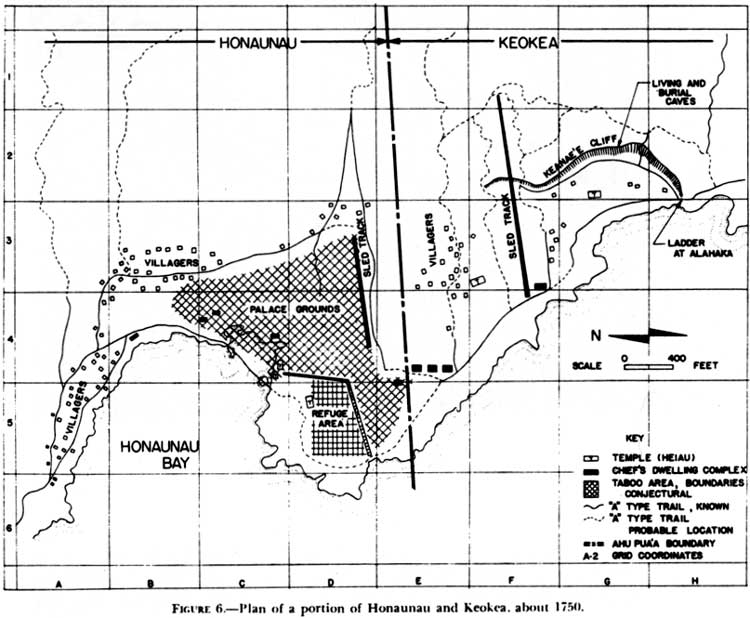
Early in the area's prehistory, a ruling chief declared the tongue of black lava flow extending out into the ocean southwest of the bay a sanctuary protected by the gods. There kapu breakers, defeated warriors, and criminals could find safety when their lives were threatened if they could reach the enclosure before their pursuers caught them. A massive stone wall around the sanctuary marked the boundary, while a heiau within the walls afforded spiritual protection. Later a temple was built at the north end of the wall to hold the sacred bones of the ruling dynasty, who would act as perennial guardians of the pu'uhonua.
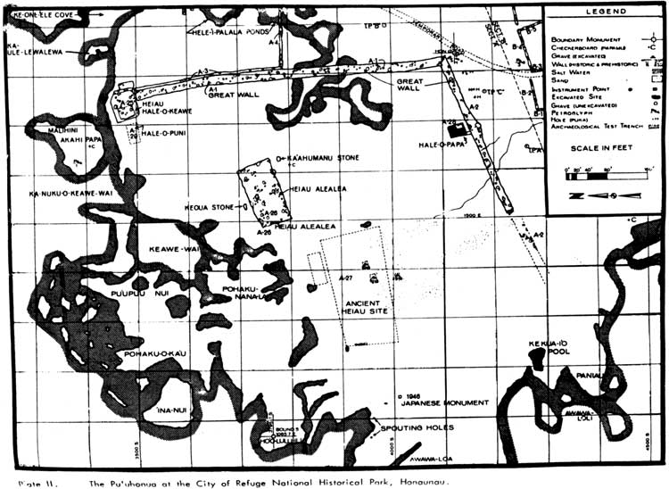
The refuge site today consists of an area partially surrounded by a thousand-foot-long wall of pahoehoe lava about seventeen feet thick and ten feet high. The north side of the structure is open to the bay and the west side to the sea. Within or next to the enclosure were several significant structures, including the Hale-o-Keawe, the 'Ale'ale'a Heiau, the "Old Heiau," and the Hale-o-Papa (Women's Heiau). Other notable features include a konane stone (papamu), a fisherman's shrine, and two large stones, one reportedly serving as a hiding place for Queen Ka'ahumanu during a quarrel with her husband King Kamehameha and the other used by Chief Keoua. A small enclosure east of Hale-o-Keawe contains two fishponds used by Hawaiian royalty. The Hale-o-Keawe housed the bones of the paramount chiefs descended from 'Umi and Liloa, some placed in wicker caskets woven in anthropomorphic shapes. This sepulchre of the very high ali'i lent Honaunau its great sanctity. The entire area surrounding the complex was densely settled in aboriginal times and is now replete with significant archeological remains.
It is clear that a well-organized society once flourished in this area. Archeological features here illustrate all aspects of ancient society relating to the religious, economic, social, and political life of early Hawaiians. This way of life began disappearing with Cook's arrival in 1778 and underwent more deterioration when Liholiho abolished the kapu system in 1819.
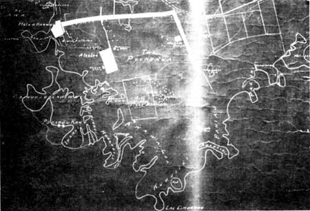  |
| Illustration 147. Portion of map "Honaunau, South Kona-Hawaii, Beach Section at Low Tide. Historical and Archaeological Remains," by John F.G. Stokes, 1919. Courtesy Kona Historical Society, Captain Cook, Hawai'i. |
 |
|
Illustration 148. Plan of Honaunau area, showing
settlements, Palace Grounds, and refuge area, ca. 1750. Figure 6 in
Apple, Trails, p. 13. (click on image for an enlargement in a new window) |
 |
|
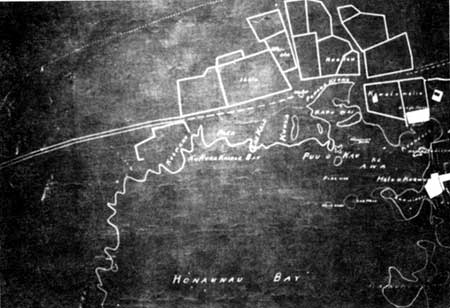
Illustration 149. Map showing extent of resources at
Pu'uhonua o Honaunau, including Ki'ilae Village to the right. Figure 1
in Ladd, Excavations at Site A-27, p. 3 (click on image for an enlargement in a new window) |
 |
|
Illustration 150. Archeological map of the Pu'uhonua o
Honaunau showing major structures and features of area. Plate II in
Ladd, "Hale-o-Keawe Temple Site," p. 164. (click on image for an enlargement in a new window) |
| <<< Previous | <<< Contents >>> | Next >>> |