PU'UHONUA O HONAUNAU NHP
A Cultural History of Three Traditional Hawaiian Sites
on the West Coast of Hawai'i Island

|
PU'UKOHOLA HEIAU NHS • KALOKO-HONOKOHAU NHP • PU'UHONUA O HONAUNAU NHP A Cultural History of Three Traditional Hawaiian Sites on the West Coast of Hawai'i Island |
|
|
Site Histories, Resource Descriptions, and Management Recommendations |
CHAPTER VII:
PU'UKOHOLA HEIAU NATIONAL HISTORIC SITE (continued)
F. Pelekane (King's Residence)
1. Significance
"Pelekane" refers to the ancient royal compound on the shoreline immediately northwest of Mailekini Heiau. The word is a Hawaiianization of "Britain" or "British," and according to some Hawaiian informants the name was given to the area because it was thought that John Young and Isaac Davis murdered the high chief Keoua here as he landed on the shore below Mailekini Heiau for the dedication of Pu'ukohola Heiau. [147] The area consisted of the royal residence and probably some housing for other members of the nobility that comprised the royal court. It is important then, not only as the residential site for generations of Big Island ruling chiefs, but as the site of the murder of Keoua and Kamehameha's assumption of the kingship of the Hawaiian Islands. It was reportedly here that Liholiho agreed to share the profits of the sandalwood trade with his high chiefs if they would agree to his ascension to the throne.
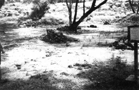  |
| Illustration 54. Pelekane area, showing stone features. NPS photo. 1989. |
2. Historical Descriptions
a) Louis de Freycinet, 1819
Pelekane was also the landing spot for foreign ships, such as de Freycinet's, during the European contact period. De Freycinet visited the new king, Liholiho, in residence at Kawaihae after his father's death. He described the royal house as
but a grass dwelling 10 to 12 feet long and little less in width; the flooring was padded with mats, as is the custom in the Sandwich Islands. Considering everything, one could not compare this royal habitation to anything better than the shepherds' huts of certain provinces in France, built for the purpose of occasional shelter. [148]
b) Jacques Arago, 1819
Jacques Arago was less generous in his description of the same:
A miserable hut, built of straw, from twenty-five to thirty feet long, and from twelve to fifteen feet broad, the entrance to which is by a low and narrow door; some mats, on which several half-naked giants are reposing . . . two chairs . . . walls made of cocoa-tree leaves, well sewed together; the roof made of sea-weed, much neglected . . . such is the palace of the monarch of the Sandwich Isles. . . . An immense number of soldiers armed with muskets, walking rapidly backwards and forwards in front of this noble dwelling, to the sound of a bell, which one of them rings at intervals; some guns pointed towards the sea, and a flag hoisted on the top of a long pole, indicate the residence of a King. [149]
c) Madame de Freycinet, 1819
Madame de Freycinet, who accompanied her husband on his journey, kept a journal as well as writing many letters about their experiences. She briefly describes some of the other structures in the royal complex at Kawaihae, first noting that the king
awaited Louis [her husband] on the beach, opposite his home. . . . His wives were not far away, under a sort of shelter, built near the shore. . . . He [Liholiho] then proposed a glass of wine which was accepted; but which had to be taken by going to another hut distant about a gunshot from the other, and which without question was the eating house. . . . My husband having gone to take his leave from the King, returned to the house of the Minister [William Pitt, Liholiho's Prime Minister], which was close to the beach...... [150]
d) L. I. Duperrey, 1819
L.I. Duperrey of the de Freycinet expedition drew the king's residence and related structures on the beach, even showing the lanai or "light shed" under which the king's wives reposed. These structures are referred to as "Maisons du Roi" in the compound area shown on his map "Plan de la Baie de Kohai-hai" made in 1819.
e) Miscellaneous Resources in Area
Illustration 44 (ca. 1889) shows a rather large structure west of Pu'ukohola standing in the shade of several coconut trees on the beach. It appears to be some sort of shelter or enclosure — possibly part of the royal compound? A local informant mentioned that in the Pelekane area, around the coconut trees, stood a fairly large beach house that he thought had been built for King Kalakaua, constructed in a manner very different from most Hawaiian homes. [151] (David Kalakaua became king in 1874.)
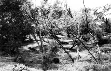
A spring, "Waiakane," reportedly exists in the water about fifty feet offshore a little south of Mailekini Heiau. This may be the spot mentioned by Ellis as a favorite bathing place of the local residents. [152] Other sites Soehren mentions in the Pelekane area include an old marine railway, several pictographs, stone fences surrounding modern house lots, a concrete-lined well that once served the Kawaihae area (possibly the spring named Waiakapea on Jackson's 1883 map), and an old charcoal oven, consisting of a low concrete dome about eight by twelve feet with a door facing the sea. [153] A local informant said that this "kiln" (Illustrations 55 and 56), constructed with a burnt coral and lime plaster, was built by a Japanese man, lori, who cut wood in this area with the permission of the Parker Ranch. [154]
The trail that passes through Pelekane on toward Spencer Beach Park is part of the old, six-foot-wide King's Trail encircling the island. [155]
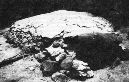 |
| Illustration 55. Door of charcoal oven in Pelekane area. |
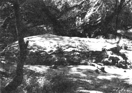 |
| Illustration 56. Side view of charcoal oven in Pelekane area. NPS photos, 1989. |
In the 1920s the Parker Ranch constructed a wagon road through the Pelekane area past Mailekini Heiau to a charcoal kiln inland of 'Ohai'ula Beach, where Spencer Beach Park is now located. This used to be a toll road for locals who found it provided easier access to the beach than the shoreline trail. The collier, the afore-mentioned lori, evidently built a second, improved road later, leading over toward the pavillion at Spencer Beach Park.
Fishermen and some hog raisers also moved into the area, living by the 1930s and 1940s along the beach in raised, temporary huts thatched with grass or coconut supplemented with odd bits of lumber, with tin or iron roofs and lanais, and with small fishponds in between. People also came just for the weekend, including wealthy haole (whites), who erected boat houses and dry-docked their boats in the area of the coconut trees. The marine railway must have been built about that time for repairing these boats. This occupation resulted in a variety of junkyards, fences, pig pens, and abandoned refuse in the area, most of which has been cleaned up. In the 1960s a concrete mixing plant stood immediately inland of Pelekane. Surplus liquid concrete resulting from the cleaning and flushing of the delivery trucks each day flowed down into the Pelekane area and can still be seen today. [156] Only a few trees mark the Pekelane area, which is surrounded by kiawe. Seeds of that plant arrived in the islands in 1828; its dense, thorny growth has obscured the platforms and stone walls delineating the former palace grounds. (Kiawe is now managed by prescribed burns to reduce growth and clear the historical scene.)
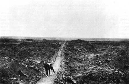 |
| Illustration 57. "King's Trail," portion from Kawaihae to Kiholo, n.d. Photo from C.S. Bond Trust, Kohalo, Hawai'i. Courtesy Hawaii Mission Children's Society, Honolulu. |
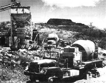 |
| Illustration 58. Concrete batch plant on state land in Pelekane area; Pu'ukohola Heiau in background. Photo by Bob Wenkam, 1969. In NPS Pacific Area Office files, Honolulu. |
| <<< Previous | <<< Contents >>> | Next >>> |