|
Kenai Fjords
A Stern and Rock-Bound Coast: Historic Resource Study |

|
Chapter 7:
THE LURE OF GOLD
Most of the Kenai Peninsula exhibits little evidence of mineralization, and mines on the peninsula, while numerous, have contributed only a minor portion of the state's mineral output. Few economically viable mines have been established on the eastern or western part of the peninsula. Extending in a generally north-south direction across the peninsula's central portion, however, is a belt of country rock consisting of alternating beds of slate and graywacke. Igneous dikes that are currently referred to as greenstones have locally intruded that rock mass. The dikes occupy fractures of irregular form and moderate extent; free gold is the primary mineral with economic importance, though sulfides are by no means uncommon. (The dikes also contain minor quantities of silver, copper, lead, and zinc.) Those dikes are found in an irregular belt that extended from the Hope and Sunrise areas south to Kenai Lake, while others are found along the North and West arms of Nuka Bay. Other mineralized areas on the peninsula are found on both the eastern and western slopes fronting on Resurrection Bay, along the Resurrection River, and additional sites scattered across the peninsula. [1]
Early Kenai Peninsula
Exploration

|
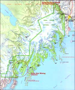
| Map 7-1. Historic Sites-Gold Mining. (click on image for an enlargement in a new window) |
As noted in Chapter 3, the first known mine on Kenai Peninsula was started at the behest of Peter Doroshin, a Russian mining engineer who visited the American colonies in search of potential mineral resources. In addition to the Port Graham coal deposits (which were mined during the 1850s and 1860s), Doroshin also found minor gold deposits along both the Kenai and Russian rivers. Little additional prospecting took place until the early 1880s, when Joseph M. Cooper sought gold near present-day Cooper Landing. In 1889, coal was extracted near present-day Homer, and the following year gold was obtained near Anchor Point. Both endeavors were commercially unsuccessful. [2]
More promising gold deposits were found along the peninsula's northern shore. A man named King discovered gold near present-day Hope about 1888, and shortly afterward, Charles Miller staked a gold claim on Resurrection Creek. The area remained fairly quiet, however, until 1893 when the creek witnessed new discoveries. Increasing numbers of miners arrived in 1894, and a remarkable find in July 1895 by John Renner and Robert Michaelson brought a major rush–perhaps 3,000 men and women–to the shores of Turnagain Arm the following year. Scores if not hundreds of claims were made in the Sixmile and Canyon creek drainages as well as within the Resurrection Creek drainage system. The towns of Hope and Sunrise boomed for the remainder of the decade, both diminishing in importance in later years. By 1911, Sunrise was practically deserted and by the 1930s most of the buildings had vanished. [3] Hope lost most of its population, too, but unlike Sunrise, Hope never "ghosted."
By the early twentieth century, prospectors had begun locating minerals in the southern peninsula as well. This may have been a result of the Hope-Sunrise excitement; the commencement of a large copper mine on nearby Latouche Island may have played a role; and the establishment of Seward in 1903 doubtless encouraged local mineral prospecting. Regardless of the reason, two claims had been staked in the Seward area by October 1904; both were located in Sunny Bay (present-day Humpy Cove) on the east side of Resurrection Bay. During the next several years, copper was found at a number of Resurrection Peninsula sites, and a minor (if well-publicized) copper rush ensued. Although the early reports on the copper claims appeared promising, no development occurred to compare with the copper mines of Latouche Island, and copper miners turned their interest elsewhere. Gold was also found in the area, most notably the Gateway Group along Tonsina Creek, but little if any production took place. By 1910, all development work for both copper and gold had ceased. [4]
Prospecting also took place during this period at the Kenai Peninsula's southwestern tip. A 1909 report noted that gold and other prospects had been located (probably since 1905) both at the west end of Windy Bay and near Port Dick. Ore quantities, however, were insufficient to justify production. [5]
Of particular interest to both prospectors and government geologists were the chromite (chromic iron) deposits west of Port Dick. Two deposits were known: one at Chrome Bay, near the mouth of Port Chatham, the other on the north side of Red Mountain, southeast of Seldovia. These deposits were known prior to 1910, but the Port Chatham deposit became of commercial interest only in 1917, when the price of ore rose because of wartime needs. [6] Whitney and Lass produced about a thousand tons of ore both that year and in 1918. By 1919, a "considerable plant investment" had been made, resulting in the production of "chrome of good quality." The company, however, mined no ore that year due to a return to prewar price levels. The plant soon closed and did not reopen. [7] At Red Mountain, commercial development did not take place until World War II. The mine operated from 1942 to 1944, and again from 1954 to 1957. [8]
kefj/hrs/hrs7.htm
Last Updated: 26-Oct-2002