|
Katmai
Building in an Ashen Land: Historic Resource Study |

|
CHAPTER 8:
TRAPPING AND OTHER SUBSISTENCE LIFEWAYS (continued)
Trapping in the Alagnak River
Basin
30) Marlette Cabin: Jim Marlette, a trapper and prospector, first came to the attention of NPS authorities in March 1948 when Fish and Wildlife Service agent Carlos Carson alerted the Mount McKinley National Park superintendent that Marlette had "a sizable illegal beaver cache in [the monument] and which he is expecting to get out soon. Of course they were caught in the park." Carson did not indicate where the cache was located, and there is no indication that Marlette (who had an airplane) had a cabin in or near the monument. Later that year, Carson also heard about Marlette's apparently successful prospecting activities inside the monument boundaries. Marlette, during this period, was apparently basing his activities along the mile-long Kulik River that connected Kulik and Nonvianuk lakes. In 1983, during the Melgenak hearings, Elmer Harrop testified that "During the 1950s, the Eskimo people were run off their land by Northern Consolidated [Airlines] and the NPS. I know that Jim Marlett [sic], who had a cabin on the Kuklik [Kulik] River, had his cabin destroyed in about 1950. He was the first person I know whose cabin was destroyed." [60]
31) Neilsen Cabin: Prior to the passage of the Alaska Native Claim Settlement Act, Johnny Neilsen established a Native claim along the north shore of Nonvianuk Lake, approximately six miles west of Kulik Lodge. A decade or so later (i.e., during the early 1980s, according to the List of Classified Structures report), Neilsen constructed a milled-log, 8' x 10' cabin and an adjacent outhouse in a protected cove on his allotment. After working out of his cabin for awhile, however, Neilsen came to the realization that the area was not good trapping territory, so he abandoned the cabin and let his allotment application lapse. The cabin and outhouse were evaluated by LCS personnel in 1993. The two buildings at that time were judged to be in good condition, and the report suggested that "the park would like to maintain the cabin as a cultural resource." [61]
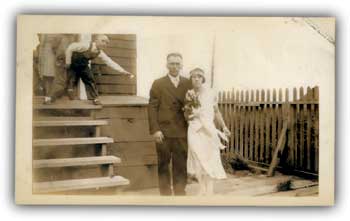
32) Murray Cabin: Sam Murray was an early area trapper. He was apparently well acquainted with the Nonvianuk River and American Creek drainages. (Murray Lake, upstream from Hammersly Lake in the American Creek drainage, is named for him.) In June 1933, an Anchorage newspaper noted that he was "working as a cook for hunters flying into the Kulik Lake area for bear hunting." Four months later, he was flying along with another hunting party that narrowly escaped disaster; their plane was forced to land in a remote area, and Murray "struck out" from there and helped rescue the remainder of the party. [62]
Murray built a cabin along the southern shore of Nonvianuk Lake (AHRS Site No. XMK-086); its specific location is just west of the mouth of a small stream in T14S, R37W, Sec. 9, SE. As noted in a List of Classified Structures survey, the site consists of a log cabin (approximately 10' x 34'), two caches, and a lumber scatter. The LCS survey, conducted in 1994, does not suggest a date for the cabin; considering the additional historical data that has become available and general trapping trends, it is likely that the cabin dates from the 1930s or late 1920s.
|
| Above: Wedding photograph of Sam Murray and wife Annie. Photo courtesty of Alvin Aspelund, Sr. NPS-LACL Photo Collection. |
33) Agate Point Tent-Cabin Complex: In June 1983, an NPS ranger located "one old log cache and two tent cabin frames" along the north side of Nonvianuk Lake, just west of Agate Point. [63]
(This point, the name of which is not recognized by the U.S. Board of Geographic Names, protrudes southward into the lake approximately four miles northeast of the lake's outflow into the Nonvianuk River.) The specific site of the cabins is T13S, R37W, Sec. 17, SW, while the cache is located in Sec. 18, NW of the same township. "Bill" Hammersly (see below) may have lived at this site prior to 1945, when he settled at the "Hammersly Cabin" site adjacent to where Northern Consolidated Airlines would later establish one of its concessions camps.
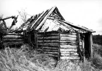
34) Hammersly Cabin Complex: Rufus Knox "Bill" Hammersly came to Alaska in 1926 and immediately settled in the Iliamna country. By 1933, he was known as an "Iliamna trader," in large part because he ran a store at the lower end of Iliamna Lake, at Igiugig. [64] For the next few years he trapped and prospected around the Bristol Bay country; during that period, in 1938, he discovered a new placer gold deposit along American Creek, near where Alex Grant had first found "colors" in 1918. In early 1945, he settled at a site on the right bank of the Nonvianuk River at the outflow of Nonvianuk Lake. According to the land records, he remained there for ten months each year until 1952. During that time he built a 12' x 20' cabin (later expanded to 20' x 20' dimensions), a cache, and a root cellar. [65]
|
| Bill Hammersly built a cabin in 1945 at the western end of Nonvianuk Lake. By 1993, the cabin had significantly deteriorated. LCS Katmai file, AKSO. |
In 1950, Northern Consolidated Airlines established a fishing camp just below his cabin complex. Beginning that year, the company hired him as a promoter of its fishing camps, a big-game hunting guide, and the Nonvianuk Camp manager. The following year, a guest at the camp noted that Hammersly had a "cozy log cabin ... and Bill had a barabara under construction. The log framework was already up and part of the sod in place." [66] Hammersly apparently severed his affiliation with Northern Consolidated after the 1952 season, but he continued living at his cabin at least a few months each year. He died at the Veterans' Administration Hospital in Los Angeles, California, in June 1959.
The establishment of the Nonvianuk concession camp, and the crowds it attracted, may have hastened the deterioration of Hammersly's cabin complex, particularly after his death. In the 1990s, the cabin (AHRS Site No. ILI-082) was visited by List of Classified Structures surveyors, who noted that the main building in the complex had dimensions of 8'6" x 26', to which was attached a 14'6" x 14'6" main living area. Portions of the cabin's roof and walls are missing.
|
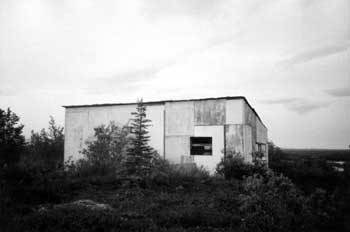
| This guide camp building, photographed in 1984, was located toward the northern end of Barbara Peterson's Native allotment along the Alagnak River. NPS-LAKA Studies Center Collection. |
35) Peterson Cabin: Barbara Peterson has a cabin on the right bank of the Alagnak River. The cabin, locally known as a trapper's cabin, is located in the middle of her Native Allotment. NPS personnel visited and photographed the cabin in 1984 and 1987; those photos show that the cabin was constructed of rude logs and a corrugated metal roof. No information is available about who constructed the cabin or when that construction took place, although it probably predates 1950. The cabin is standing but is in deteriorating condition.
36) Guide Camp Cabin: Near the north end of Barbara Peterson's allotment is a plywood, shed-roof building that NPS personnel have described as being associated with a guide camp. Agency personnel visited and photographed the site in 1984 and 1987. No information is available about who constructed the cabin or when that construction took place, although its condition and construction style suggest that it was built in the past thirty to forty years.
37) Apokedak Cabin Complex: Nick Apokedak has a historic cabin and cache on his Native Allotment near the right bank of the Alagnak River. NPS archeologists visited, mapped, and photographed the site in June 1997 (see AHRS Site No. DIL-160). No architectural or historical details about the cabin are known.

|
| One of the major points of interest along the Alagnak River is the Agnes Estrada cabin complex, as shown in this 1984 photograph. NPS-LAKA Studies Center Collection. |
38) Estrada Cabin Complex: On the Agnes Estrada Native Allotment are located a cabin, boat house, shed, outhouse, trash pit, mound, and the "outlines" of previous rectangular buildings or other disturbances. Ms. Estrada's main cabin is clearly visible and is easily identified by those passing by on the Alagnak River. The complex was visited and photographed by NPS personnel in 1984. Thirteen years later, an archeological team surveyed the site (AHRS Site No. DIL-163) in search of prehistoric and historic resources. Neither visit, however, gleaned information about the history of the structural complex. An area guidebook notes that a "landmark" along the Alagnak River is "Agnes Estrada's rustic log cabin," where "you may see caribou antlers hung over the door." It stated that Estrada lived in the cabin for most of her life, snaring animals until she was nearly 90 years old. [67]
39) Andrew Cabin Complex: Two miles downriver from the Estrada Cabin Complex is a cabin on Wassillie Andrew's Native Allotment. This cabin, like Estrada's, is along the river's right bank and a sign on the cabin wall plainly identifies the cabin's owner. The cabin's walls are composed of rough-hewn logs, while its roof is corrugated metal. At least one outbuilding lies nearby. The cabin was visited and photographed by NPS personnel in 1983, 1984, and 1987. Nothing is known about the history of the structures on the property.
40) Lower Alagnak River Cabin Complex: In 1997, NPS archeologists located and identified a complex of historic and prehistoric items (AHRS Site No. DIL-161) along the right bank of the Alagnak River, near the lower end of the Alagnak Wild River. Historic resources included a cabin, two outhouses, a shed, collapsed sauna, and historic debris. This site, unlike the other five along the Alagnak, is not located on a known Native allotment. The investigators noted that the cabin "appears to have been built circa 1940 and has seen occasional use but is currently in a state of disrepair, and the outbuildings are in a deteriorated condition."
katm/hrs/hrs8d.htm
Last Updated: 22-Oct-2002