|
Katmai
Building in an Ashen Land: Historic Resource Study |

|
CHAPTER 8:
TRAPPING AND OTHER SUBSISTENCE LIFEWAYS (continued)
Trapping Along the Shelikof Strait
Coastline
1) Kamishak River Cabin: At or near the mouth of the Kamishak River is a cabin site. Evidence of the site was published in a July 1929 newspaper article, which mentioned that two brothers from the Iliamna country, Walter and Ole Wassenkari, would "throw out trap lines" in the vicinity of Kamishak Bay that winter. Ole Wassenkari, the article noted, would live "in the cabin at the Big Kamashak [i.e., Kamishak] River." In his later years, Mr. Wassenkari (1899-1984) lived along Ole Creek (a tributary of the Kvichak River) just west of Iliamna Lake; he worked as both a "Bristol Bay fisherman and a Kvichak-Iliamna trapper." [13] The cabin was probably used for trapping for a short time, if at all. The specific location of the cabin is not known, and nothing is known of the cabin's condition. As has been noted in Chapter 6, there was a flurry of oil-lease activity along Kamishak Bay and the Kamishak River in the early 1920s; the cabin may have been built as a result of that activity.
2) Cape Douglas Cabin: On the northwest side of the Cape Douglas headland is located the ruins of a sod and plank cabin. Nearby is a storage cache or shed, built of upright wooden planks, along with a possible second cache. The house ruin consists of a 4 x 5-meter rectangle of low sod walls banked against vertical planks, with stumps of upright posts. Loose, horizontal planks from the roof or walls of the house are scattered across the foundation and outside. The boards contain drawn wire nails. A small cast iron stove with a square flue sits inside the house. The complex dates from the 1940s or 1950s; who built the structures, or why, is unknown. Archeologists discovered the site in 1994; it is now registered as AHRS Site No. AFG-199. [14]
3) Chiniak Lagoon Cabin: George Stroud and Lynn Fuller, in their 1984 report, noted that one map of the area showed "a cabin on the peninsula one mile northwest of Cape Chiniak." The two did not visit the cabin, however, and no other records about the cabin are known to exist. Should remains of the cabin still exist, they are probably located near the end of the spit north of the lagoon mouth. Who built the cabin, or why, is unknown. [15]
4) Hallo Bay Cabin #1: A cabin was built along the western shoreline of Hallo Bay, approximately 1-1/4 miles south of where the Ninagiak River debouches into the bay. Who built the cabin, or why, is unknown. In June 1976, park interpreter Carolyn Elder visited and photographed the cabin, which was located in an alder patch. She also learned during an interview in Kodiak that "a gentleman by the name of Gene Weaver" had the cabin; his probable residence was a community on Kodiak Island. The cabin photo is located in the park collection. [16]
5) Hallo Bay Cabin #2: A cabin was built on the south side of Hallo Bay. The location of the "old cabin" has been variously described as being "1/2 mile from beach" and simply "south side Hallo Bay." These two photo captions probably describe the same cabin; if so, its probable location is on a small rise just south of a large pond in T20S, R29W, Section 34, SE1/4. Who built the cabin, or why, is unknown. Park interpreter Carolyn Elder, in 1976, learned that Gene Weaver had both this and the other Hallo Bay cabin. In May 1978, ranger Rollie Ostermick visited and photographed the cabin. Two cabin photos with that date are located in the park collection. [17]
6) Kukak Bay Cabin: As part of a series of tape recordings she made during the mid-1970s, Carolyn Elder learned that Jake Amuknuk had a cabin at the head of the bay. Mike Tollefson's 1977 report notes that the man hailed from Kodiak. [18] No information is available about the cabin's location, history, or condition.
7) Kuliak Bay Fish Camp: As part of his operation, John A. Smith (see below) had a fish camp just north of Kuliak Bay, at the head of the peninsula just south of Cape Gull. It was probably active in the late 1930s and early 1940s. Smith probably never constructed more than a tent and a series of fish racks at this site. [19]
8) Takli Island Trapping Complex: As noted in chapter 9, federal authorities administered this site (AHRS site number XMK-073) as a fox farm. In actuality, however, the only known site occupant used the complex as an illegal trapping headquarters. Fur farm leases were taken out for the island in December 1928 and July 1931, but neither act was followed up by on-site settlement. Then, in 1937, John A. Smith applied for a fur farm lease. Smith soon built a cabin and two caches on the island's northeastern quadrant, and in 1939 his lease was approved. But instead of establishing a fur farm, he illegally hunted mink, marten, beaver, and fox within Katmai National Monument. As a result, he lost his lease in May 1942. Eleven years later, an NPS aerial photo showed a large cabin, a smaller cabin or shed, and a shed built into the hillside; all were probably erected by Smith during his five-year tenure on the island. These structures deteriorated over the years; they were still standing during the early 1970s, but by 1991 all had collapsed. It is recommended that NPS cultural resource personnel conduct a survey of the site's historical archeology. [20]
9) Kashvik Bay Cabins: In 1917, a National Geographic Society group stopped at Kashvik Bay as part of a Valley of Ten Thousand Smokes expedition. Photographs taken from that trip show two cabins in the bay: a "prospector sod house" and a "cabin on Moose Creek." The locations for both structures are indefinite, inasmuch as the sod house was not further identified and the name Moose Creek is not an official name for any watercourses in the bay's drainage. The only suggestion regarding who built them is found in Mike Tollefson's 1977 letter in which he noted that "Freddie Grindell's father" had cabins at Kashvik and other bays along the Shelikof Strait coastline; he trapped foxes in the vicinity of those bays (according to his son) in the 1920s and 1930s. [21] Perhaps the Moose Creek cabin was used for trapping, while the "prospector sod house" was used in conjunction with the Mason brothers' gold extraction activities along Lonesome Pine Creek, near Cape Kubugakli. (See Chapter 6.)
|
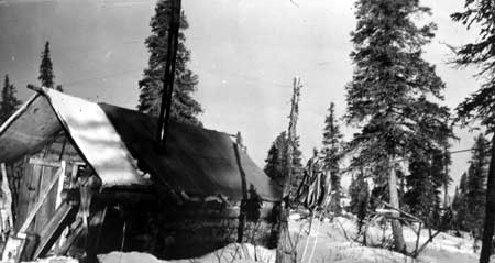
| This photo of Johnny Monsen's Reindeer Point (Northwest Arm) cabin was taken about 1940. NPS-LACL Photo Collection, courtesy of Dorothy Berggren. |
katm/hrs/hrs8b.htm
Last Updated: 22-Oct-2002