|
Jefferson National Expansion
Administrative History |

|
|
Administrative History Bob Moore |
CHAPTER TWELVE:
The East Side Expansion: Taking the Dream Across the River
The construction of the Gateway Arch and the development of Jefferson National Expansion Memorial sparked a renovation of downtown St. Louis, which was hailed as a magnificent success. Many people believed, however, that such development and success should not be limited to the west bank of the river. For 30 years, plans for reviving the East St. Louis riverfront were proposed by a variety of groups and organizations, and the National Park Service was heavily involved. [1] In fact, the original concept for the memorial involved the incorporation of areas on both sides of the river into the plan. [2] In architect Eero Saarinen's words:
We would hope that this side of the river could be developed so that it, too, would become part of one great composition. We see it as another green area. Besides being part of the whole composition — with the Park and the cityscape framing the green oasis of the Park — it would provide a vantage point from which to view the Arch and the Court House and the levee buildings and the boats; it would make a pleasant backdrop across the river to look at as one sits in the restaurant or on its terraces or walks through the park; and it would provide additional areas of pleasure for St. Louis citizens and the nation's visitors. [3]
The plan called for forested green spaces, museums, a marina and boat basin, formal gardens and landscaping, and an amphitheater along the water's edge, with parking, a grassy recreational area, access roads, and a sports stadium on the periphery. [4] Unfortunately, obtaining sufficient funds for the west bank development proved to be difficult, and Saarinen's plans for the east side were never implemented.
Over the years, however, the idea of an east side park continued to surface. Some proposals were motivated by commercial interests. As part of a "Gateway Memorial City," a 12-story hotel and private boat dock were suggested for the area. A subsequent plan proposed a shopping center, 1,000-room hotel, art museum, museum of science and industry, theater, replica of a historic river town, convention hall, and fairgrounds. [5]
A master plan prepared in 1960 for the City of East St. Louis Planning Department called for a narrow park surrounded by industrial facilities, and at one point the East St. Louis planning department proposed a black heritage museum. In 1966, PACE (Progress and Action Through Citizens' Efforts) plans outlined an educational park, transportation museum, and athletic fields surrounded by industrial and high density residential areas, with estimated costs totalling $750 million. [6]
Official National Park Service (NPS) interest in the study area began in December 1967 when United States Representative Melvin Price (D-23rd Congressional District, IL) asked for an investigation of the historic value of the East St. Louis riverfront as a first step toward the creation of a national park. The positive results of the investigation were submitted to Secretary of the Interior Walter Hickel on April 24, 1969. In July 1969, Secretary Hickel instructed the Park Service to conduct a suitability and feasibility study for such a national park. [7]
|
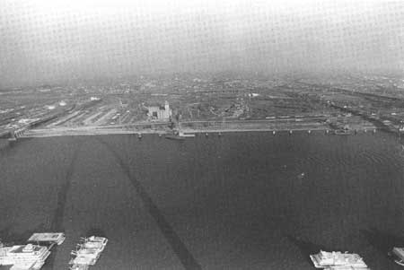
| The East St. Louis landscape as seen from the top of the Gateway Arch. NPS photo by Al Bilger. |
The result of the NPS study was a proposal for the development of a portion of the East St. Louis riverfront. This proposal was submitted to the State of Illinois, which happened to be in the process of preparing a proposal for NPS development of a portion of the Shawnee National Forest. [8]
The East St. Louis proposal received strong political support from U.S. Senators Adlai Stevenson III (D-IL) and Ralph Smith (R-IL) and Representatives Kenneth Gray (D-W. Frankfort, IL) and George Shipley (R-Olney, IL). As a result, numerous proposals for potential riverfront development were generated by various organizations and agencies, including the Metro-East Journal, the Gateway Center of Metropolitan St. Louis, Inc., the Regional Industrial Development Council, and the Bi-State Development Agency. [9]
In a 1970 study, the Park Service proposed four alternatives for the east side: a city park; a state park; an extension of JEFF; and a national urban demonstration park. [10] The first two alternatives were eliminated due to lack of local funding. [11] In 1972, the NPS completed a Statement for Management and Planning (Management Objectives), based on the idea of an extension of JEFF to serve as an urban demonstration park. In 1974 a draft of a master plan, based on the same concept, was prepared for the NPS under contract by R.W. Booker Associates of St. Louis. [12] After a review, NPS officials reported that the plan had serious flaws and did not adequately justify Park Service involvement. At the same time, however, they were careful to explain, especially to Congressman Price, that they were still willing to work toward an acceptable solution. Accordingly, the master plan was further enhanced by NPS planners at the Denver Service Center. [13]
In January 1975, a furor arose when a national citizens' advisory committee to the NPS decided against the plan to expand JEFF. Citing the prohibitive costs of relocating the railroad tracks and grain elevator which stood on the east side property, the committee stated that the east side was "not suitable for park purposes." This decision brought a storm of protest from local proponents of the plan and renewed commitments from Rep. Melvin Price to push legislation through Congress. [14]
In response, the NPS maintained that the citizen's committee was purely advisory and that no final decisions had been made. In a meeting between NPS officials and Price, the congressman conceded the NPS' position regarding the inadequacy of the Booker plan. The NPS, for its part, assured the congressman that work would continue. [15]
To make good on that promise, the NPS prepared yet another special study of the east side in 1975. It recommended that a 55-acre area between the Eads Bridge and the Poplar Street Bridge, along the riverfront, be acquired; that there be strong cooperation with other current area planning; and that a cross-river transportation system be utilized. It was also recommended that no NPS development take place until the railroads and industrial facilities were acquired or relocated by other parties. The Park Service was still unwilling and unable to take on those two formidable projects. [16]
Support for the project grew among politicians and local businesses, however, and Rep. Melvin Price refused to give up. In May 1978, he advised the NPS Regional Office in Omaha, Nebraska, that the Federal Railway Administration was involved in a gateway restructuring plan which could result in removing the railroad facilities. By 1980 this study was nearing completion and the project began to attract the attention, once again, of state and federal officials. [17] In 1983, Price introduced a bill in Congress that authorized the Secretary of the Interior to enlarge JEFF by approximately 350 acres. [18]
Meanwhile, a non-profit, private group called the Gateway Center of Metropolitan St. Louis, Inc. was acquiring land which might adjoin a proposed national park site on the east side. It was hoped that the NPS would eventually purchase this land as the East St. Louis extension to JEFF. Plans for the 50 acres of land included a Museum of Science and Industry, an extension of the Museum of Westward Expansion, a Cinerama dome which would show 360 degree movies, and a geyser jet fountain based on the Jette d'Eau in Geneva, Switzerland, which would erupt "to half the height of the Arch at least twice daily . . . " [19] Superintendent Jerry Schober remembered the east side project as one of the first issues he had to address upon his arrival in St. Louis in 1979:
[The] Regional Director came to me and said, "Jerry, you know they're looking at introducing . . . the legislation for the east side. There have been many studies, and the Park Service's position has been fifty acres, and I was wondering how you felt."
And I said, "Well, I would certainly not support it. . . . Not fifty acres, fifty acres would give you a headache. You're gonna have something the size of a thimble sitting right in the middle of all sorts of aggravation, it could do only one thing and that is to cost the Federal Government big bucks."
And he said, "What would you suggest?"
And I said, "A minimum of two hundred and fifty to three hundred acres. That way it takes you back to the berm, it takes in everything over there, not necessarily what you've got to buy, but you need to be at a place where you're your [own] neighbors." [20]
The prime mover of the Gateway Center project for the east side was St. Louis lawyer Malcolm Martin, who met with Illinois Representative Paul Simon on February 13, 1983. Simon pitched the idea of a museum of cultural heritage for the site, "patterned somewhat upon the famous National Museum of Anthropology in Mexico City." Martin liked the idea, which received strong congressional support. [21]
As part of the planning effort, $100,000 was authorized by President Ronald Reagan on November 5, 1983 for the Park Service to conduct a feasibility study for a Museum of American Culture and Anthropology. [22] The study was prepared by the NPS' Denver Service Center and the Washington Office Park Planning and Special Studies Division. This coincided with Price's latest legislation and was meant to determine if East St. Louis was an appropriate location for the proposed museum. [23] The NPS opposed the plan. Richard Briceland, acting director of the NPS, told a House subcommittee on November 15, 1983 that the East St. Louis riverfront was "not of significant historical value to warrant the creation of a national park site," according to St. Louis newspapers. "He also said the plan would be too expensive . . . 'The development and cleanup of the East St. Louis waterfront is a worthwhile local or regional goal,' Briceland said. 'However, we do not encourage the donation of land to the National Park Service, as we understand some have proposed.' His comment drew sharp rebuttals from numerous regional officials, as well as five members of Congress from the St. Louis area." [24]
On August 24, 1984, President Reagan signed Public Law 98-398, the Jefferson National Expansion Memorial Amendments Act, which authorized the enlargement of Jefferson National Expansion Memorial to include up to 100 acres on the east bank of the Mississippi River in East St. Louis, Illinois. The act was signed despite objections from the Department of the Interior. [25]
The decision to expand the park came in recognition of the historical links between the east and west riverbanks during the period of United States westward expansion, and because of the broad national and international significance and appeal of the Gateway Arch, situated directly across the river. An addition to JEFF would complete the "Gateway to the West" represented by the Mississippi River and its east and west banks at East St. Louis and St. Louis. [26]
To bring a broad cross-section of financial and human resources to this project, Congress created the Jefferson National Expansion Memorial Commission, and charged it with overall responsibility for the development of a plan for the East St. Louis addition to JEFF. Accordingly, the NPS submitted a charter for such a commission to the Secretary of the Interior. [27] The formation of the commission was delayed while its charter was reviewed, and it was not until October 8, 1985 that Secretary of the Interior Donald Hodel appointed 20 members representing the local, state, and national jurisdictions with an interest in the monument and the East St. Louis waterfront. This group contracted with the National Park Service to provide technical planning assistance, but decision-making authority remained vested in the commission. [28] The commission was mandated by Congress to complete a management and development plan to extend JEFF to the East St. Louis riverfront. Legislation provided $1 million for land acquisition not to exceed 100 acres in fee; $750,000 for a visitor center; $350,000 for operating costs; and $500,000 for landscaping and renovation to be matched on a dollar by dollar basis with non-federal funds. [29]
Congress specified that the plan address the following topics: the preservation of any historic properties or significant natural resources within the area; a determination of how the east bank addition should be developed; the capacity of the site to accommodate visitors; any potential boundary modifications; commitments to ensure compatibility between development, management, and operation of the Illinois and Missouri units of JEFF; commitments to cooperative activities and funding from federal, state, and local agencies and the private sector; and ways of increasing local participation in management. Throughout the scope of the plan, Congress called for cooperation between government and the private sector in the development of the East St. Louis addition, and for the commission to address the larger topic of the aesthetic and economic rehabilitation of the East St. Louis waterfront. Costs were borne jointly by the Park Service, state and local agencies, and the private sector. Federal funding for the project was limited to $1 million for land acquisition, $750,000 for development, and $500,000 for landscaping, providing that the funds were matched dollar for dollar with non-federal funds. Congress went on to specify that no plan for the East St. Louis site could be approved unless it included "binding commitments" for all non-federal funding needed to implement the plan. [30]
Superintendent Schober recalled some of the struggles involved in making the Department of the Interior understand the importance of the site:
We [found] out how much commitment Interior was going to have toward [East St. Louis] by seeing that it took the Secretary's office almost seventeen months to accept the representatives, and yet the planning commission had two years by the legislation to get its plan out. When we had our first meeting . . . the representative for the Secretary of the Interior was P. Dan Smith. The Park Service [felt] two things for him: feared him or hated him. And Danny was recognized by the Park Service as a hatchet man. I personally liked him. Danny got things done. I had no problem convincing Danny even when he thought he was right if he really wasn't. I don't know, maybe he and I just hit it off. Anyway Danny came down. Based only on what I'd heard, after listening to him I felt that he was going to put an end to [the east side expansion idea] right quick.
And so after the first day's meeting we went out and we looked at the land, and it was on a gloomy, gray day, cold, misty. Sure wasn't anything over there that would excite you about complementing the park on the west. And yet in the hearings, the chairman of the subcommittee on parks was Rep. John Seiberling, and his pitch was that there's nothing prettier to see from the east side than to look at St. Louis, the Gateway Arch, and the cityscape, it's just beautiful. He said that it's just a dang shame that when the west looks to the east, they can't get the same picture. And he could see where this small enclave of land would be a welcome addition, so he supported it. So we got Danny here with the team, representing the Secretary of the Interior, and I think the first thing that we did that morning was to take him up in the Arch and let him look out from the observation deck at the east side. . . . It looked so dismal, and so gray, and so bad; and then we went over there to the east side and experienced it first-hand. I said to them, "What you see over here is what you would have seen in the 1940s and 50s in St. Louis. That Arch was the catalyst for stopping a departure of business from the city, and was the beginning of a great era of development; it started with a hundred million dollars and by the time I got here it was one billion dollars invested right here in this enclave on the west side. You can see what a catalyst the Arch can be; what can happen to a piece of land that looked just like the east side at one time."
I didn't know what headway I'd made. We had a cocktail party right after we spent the day on the east side. We went to the Holiday Inn, and I could hear Danny going to each one of them, saying "I think we ought to have an election." . . . And so I'm trying to follow him. And he was working the crowd. He was great. He never slept. He was always working. That's what I really admired about him. And all of a sudden, I'm trying to run along to hear what he's saying, and he wheels around on me and he says "Jerry, don't you agree with me?" I'd been trying to piece it together, and I said "What is that, Danny?" He said "I was telling them, I think it's time we elected someone chairman. We should get a group here so they can work, but I don't think that anyone elected should be someone representing a federal entity such as myself." And I was so relieved, and I thought that's just the direction we ought to have. Well he wasn't through. . . The next morning, we went to the east side and held our meeting at the community college, and Danny got up. "I think before we start this meeting, I will say something to you. I came here with a bad taste [in my mouth]. I felt like this was a boondoggle I couldn't support. I'm still thinking about what I saw from the Arch looking at the east side, and when I heard Jerry say: "'What you see over there was what you had right here on the west side; look what we can do when we work together.'" He said: "I am going back to Washington after I leave here, and I'm going to say to the Secretary of the Interior, I think this is something we ought to do, and please make me your permanent representative." . . . He never did anything that I was aware of that was other than what he expressed to that group. He pushed, he helped, the sad thing was that he transferred out of Interior about three weeks before the package was to be signed by the Secretary of the Interior. The Secretary never approved the plan; it was unanimously approved by his representative, who was another assistant to the Assistant Secretary, and I think his intent was to try to kill it, but he couldn't . . . [31]
To fulfill its mandate, the JEFF Commission arranged with the NPS to prepare a Development and Management Plan and Environmental Assessment. Although only 100 acres were authorized for inclusion in the park, an additional 200 were included in the study area, to enable the commission to consider compatible use for areas adjacent to the park. The boundaries for the study area were set at the river, the Eads and Poplar Street bridges, and the I-55/70 interchange. Twenty-five of these acres were freed when the Chessie System Railroad closed its switching yard south of the Eads Bridge. [32]
As a first step in the development of a management plan, NPS officials let a contract for data collection on October 8, 1985, to TDP/St. Louis, Inc. The final cost of the data package totaled approximately $60,000, with a target date of April 1986. [33] Data included the identification, evaluation, and preservation of cultural resources, and the preparation of development proposals that would best serve the requirements of the NPS and the East St. Louis community. [34]
On November 25, 1985, the first meeting of the JEFF Commission was held at the Old Courthouse and officers were elected. At a second meeting in March 1986 the commission established the scope of the project, and allocated $50,000 to the NPS for the planning process. Public meetings were held in St. Louis and East St. Louis during the summer of 1986, enabling the commission to develop six possible planning alternatives. Approximately 1,500 copies of a planning booklet were distributed, and comments and recommendations were solicited. [35]
The alternatives were designed to represent the numerous concerns identified by the public and by local, state, and federal agencies. They focused on the proposed 100-acre addition to JEFF, but also suggested appropriate uses for adjacent lands. By December 1986, the National Park Service completed its Draft Development and Management Plan, which described how each alternative might be implemented and analyzed for environmental impact. [36]
The alternatives considered were:
(1) A Gateway Park, which proposed an open green area on the east bank as a backdrop and viewing platform for the Gateway Arch. The emphasis was placed on the scenic and open space values of the site, which, cleared of intrusive structures, revegetated, and improved with walkways and scenic overlooks, would provide magnificent unobstructed views of the Arch.
(2) A Gateway Monument favored the vision of a complementary monumental feature on the east bank directly across the river from the Arch. Like the Arch, it was suggested that the proposed memorial be selected by an international design competition sponsored by the JEFF Commission, a recognizable monumental feature which would attract visitors to the east bank.
(3) A proposed Gateway Museum enhanced the value of the site by creating a new cultural resource. Two museum options were considered. A "world-class" museum provided a focal point and attraction for drawing national and regional visitors to the east bank, and would be managed by a non-profit organization and operated by a staff of eminent museum professionals. Another option was the extension of JEFF's Museum of Westward Expansion, to be operated by the NPS.
(4) A Gateway Heritage Park was planned which focused upon the diverse cultural and natural resources of the area, and helped visitors to understand the historic events that occurred there and their relationship to the story of American westward expansion. Multiple attractions were combined in a pleasing park environment that enhanced views to both the east and west.
(5) A Gateway Plaza mixed commercial uses with open space to attract visitors and residents of the community and region. Existing structures were utilized for commercial purposes and the emphasis was placed on developing the site's economic potential. [37]
While the Commission developed these plans, work progressed on the museum suitability study. On June 26, 1986, the NPS selected Economics Research Associates of Vienna, Virginia, to undertake the study. A work session was held in St. Louis on July 8-9, 1986, with a theme identification/description session on August 18-19.
The NPS provided two potential themes, falling under the general heading of American Culture and Anthropology: the contribution of ethnic groups to the development of the United States, and the relationship of Native Americans to their environment. The objective of the session was to gather a small group of museum specialists, NPS personnel, and other interested parties to discuss these themes, and decide if they represented viable concepts for a major museum. The final study was completed in January 1987, and four theme alternatives were proposed:
A "First Americans Museum" examined the movement of American Indian peoples and the adaptation problems associated with this movement prior to European contact.
A "Museum of American Settlement" told the story of Euro-American and African-American immigrants, their settlement patterns, cultural interaction and change.
A "Museum of American Landscape and Man" studied the North American landscape and its changes under human settlement; and
A "Museum of American 20th Century Culture" dealt broadly with a "nation in motion." [38]
At its December 6, 1986 meeting, the Commission selected the Gateway Museum (number three, above) as its preferred alternative, and a draft plan was presented for public review. The Commission removed the museum proposal from the draft development and management plan, however, at its next meeting on February 27, 1987. It stated that although it supported the concept of a museum as part of the future development of the east bank addition, it believed that decisions on the nature, design, and financing of the museum were beyond its authority. The Commission instead opted for a phased approach to the development and management of the East St. Louis site. [39]
Initial priorities were the acquisition of the 100 acres for inclusion in the memorial, site clearance, construction of a visitor promenade, formal landscaping, and development of easy access to the site. Under the terms of the proposal, the memorial boundary included the entire Mississippi River shoreline between Eads Bridge and the Poplar Street Bridge with the park oriented to the east-west axis of the Gateway Arch. During phase one, a central plaza would be developed, with an elevated paved promenade extending to the north and south, parallel to the river. The levee bank would be maintained as a grassy slope. The riverfront landscaping would mirror the existing west bank design with paved surfaces and formal plantings, providing a pleasant place to walk between the levee and the river. Commercial riverboats offering dining, entertainment, and perhaps lodging could be moored at the north end of the site. [40] During phase two the public sector, or a private non-profit organization, would develop and operate a museum on the site. The museum building would be a prominent and attractive feature on the East St. Louis skyline, designed though an international competition to enhance but not compete with the Arch. A lengthy period of time would probably elapse before the required funding was available for phase two. [41]
The interpretive focus during phase one would be the history of the east bank site and its relationship to the story of westward expansion. Wayside exhibits and programs would be available along the promenade. Topics would include the first Mississippi ferry, the historic Illinoistown site, the railroad terminus on the east bank, Eads Bridge, the Arch as a monument to westward expansion, and Mississippi River ecology. During phase two, the cultural and interpretive values of the site would be greatly expanded by the addition of the museum. [42]
The plan won strong support from the U.S. congressional delegation, Illinois Governor James R. Thompson, Missouri Governor John Ashcroft, and from numerous business leaders in East St. Louis and St. Louis. On May 28-29, 1987, two public meetings were held to review the plan, and the public response was generally favorable. The final plan was completed on September 16, 1987 and transmitted to the Secretary of the Interior. [43]
In February 1988, further progress was made when the City of East St. Louis promised $300,000 to assist in the development of the park, and announced that it would sign over the streets and other city-owned facilities in the park area. In addition, the Gateway Center of Metropolitan St. Louis, a private non-profit organization, stated it was prepared to donate to the National Park Service 52 acres that it had acquired on the east bank. [44] On April 20, 1988, Illinois Governor James Thompson wrote to the Secretary of the Interior to inform him of key commitments by the State, namely the creation of the Southwest Illinois Development Authority (SWIDA), an independently-appointed commission with the ability to develop non-park areas of the East St. Louis riverfront. One of SWIDA's primary responsibilities was the purchase and development of the 200 acres surrounding the proposed park. [45]
In June 1988, the Director of the National Park Service sent the Development and Management Plan to Secretary of the Interior Donald P. Hodel. In July, Hodel forwarded it to the Committee on Interior and Insular Affairs of the House of Representatives, and to the Committee on Energy and Natural Resources of the U.S. Senate. He did not, however, officially approve it. Explaining his position, Hodel stated that " . . . the acquisition of binding commitments has proven to be an elusive goal. . ." Because of this Hodel could not give his approval " . . . until those commitments are obtained, pursuant to the law." [46]
In an attempt to get around this obstacle, new legislation was introduced in the House of Representatives on April 18, 1989, by Congressmen Jerry Costello, William L. Clay, and Richard Gephardt, that removed the size limitation on the addition, allowed acquisition of state lands by means other than donation, authorized increased funding for land acquisition, and eliminated the "binding commitment" provision. This allowed the NPS to formally certify the new park without necessarily tying up all the loose ends. [47]
In the meantime, Representative Costello and Senators Alan Dixon and Paul Simon (IL) met with the new Secretary of the Interior, Manuel Lujan, and were told that the site would be designated if the property was donated and there were no environmental problems. In September 1989, the Illinois Governor's office agreed to request the State Environmental Protection Agency to perform toxic chemical surveys on the site. [48]
In February 1990 SWIDA accepted 17 acres from the Gateway Center, and other land from the Southwest Regional Port District to hold in escrow. On April 5, St. Louis businessman Bill Maritz met with President George Bush and White House Chief of Staff John Sununu, and sought their support for designation of the site as a national park area. On April 16, the Illinois EPA completed its environmental assessment (Level II and III surveys) on the 17 acres, which indicated that no toxic chemicals existed on lands proposed for donation/acquisition. [49]
Proponents of the east side expansion saw an opportunity to achieve their goal by capitalizing on the symbolism of the 25th anniversary of the completion of the Gateway Arch, October 28, 1990. [50] They were at least partially successful in their efforts. On October 28, in a public ceremony, NPS Director James Ridenour and Earl Lazerson, Chairman of SWIDA, signed a Memorandum of Understanding, to which Secretary of the Interior Lujan added his signature on November 1. In the agreement, SWIDA promised to acquire land for donation and to obtain binding financial commitments required for final approval. Lujan promised to designate the site once the lands were donated. [51]
In a further development, in November 1990, SWIDA obtained permission from the Terminal Railroad Association and Continental Grain, two of the largest landholders on the east side, for an environmental analysis of their lands. Union Electric and the City of East St. Louis also gave permission for testing to be performed on their property. [52] Superintendent Schober recalled:
I don't think the Secretaries of the Interior, (and you notice I made it plural), ever totally were made aware of what was here. I don't think they ever made a decision that was with any real understanding. . . . Yes, that Southwest Development Organization is out there, but it's now functioning just as development . . . There can be jobs where parks come. I can't think of a place in America where there is a National Park or some kind of park, that we haven't escalated the cost of the land, that we haven't been a benefit to the community. And we could very well do it here. The biggest thing that you have to do in communities like East St. Louis . . . is to show them that this park is in their community, it is not their park alone. The minute it becomes their park alone, it means no more than any city park in America, and that doesn't draw people from anywhere. If this was Forest Park II on the west side, how many people are going to leave Paducah, Kentucky, and run here and see a city park? . . . When they come to St. Louis, the Arch is their Arch, just as much as it's St. Louis' Arch. That's very difficult — you have to keep helping them retain a vision of the big picture for the east side. [53]
Representative Jerry Costello (D-Belleville, IL) introduced a bill to require the Federal Government to extend JEFF to the east side on July 17, 1991. This bill was signed by President George Bush on August 26, 1992. The bill designated the site of the new park, authorized as much as $2 million to acquire the site, and removed a requirement of the 1984 law that East St. Louis make "binding commitments" to help pay for operating the park. The bill required a 25% local match in funds for park development, similar to the original 1935 agreement for JEFF. The approval of this bill was the potential beginning of a new era for JEFF, opening the way for Saarinen's dream of extending the park across the river, and revitalizing the purpose of JEFF as an urban park area. East St. Louis Mayor Gordon Bush was quoted as saying that the park would be "the vanguard . . . in the rebirth" of his city. JEFF Superintendent Gary W. Easton said that "the City of East St. Louis has almost nothing except opportunities, and the expansion of the park is seen as a major contributor to the city's future." The 1990s promised to be a dynamic decade at JEFF as this dream unfolded. [54]
| <<< Previous | <<< Contents >>> | Next >>> |
jeff/adhi/adhi2-12.htm
Last Updated: 15-Jan-2004