Administrative History

|
Hopewell Culture
Administrative History |
|
CHAPTER NINE
Interpreting the Mound City Group (continued)
| Interpretive Dilemma: The Prehistoric Landscape |
National Park Service Director Conrad L. Wirth approved the MISSION 66 Prospectus for Mound City Group National Monument on June 3, 1957, with the added provision for "restoration of ground cover to approach that of the historic period of the mounds." [29] Indeed, the goal to convert the grassy, heavily mowed landscape to more natural, aboriginal conditions had been a National Park Service goal for the national monument since the agency assumed management responsibility in 1946. It became a practical necessity from a management standpoint considering the manhours and equipment needed for mowing operations. With the lack of funds to achieve reforestation, Clyde King began planting seeds and transplanting young trees himself. Interpreters trying to relate the Mound City Group landscape to the time of Hopewell use, however, had the greatest difficulty convincing visitors to see beyond the green, evenly-cut turf, which clearly reflected the ideals of twentieth-century America, to a dim forested reality of centuries past. Turf management practices designed for golf course beauty had to be abandoned at Mound City Group. The goal became embedded in planning documents ranging from the 1965 master plan to interpretive prospectus to the archeological research management plan.
Landscaping around the 1960 visitor center was itself designed to place the new building in a forested setting to reflect what the larger restored scene would one day appear like. Yews were to be maintained as a "loose informal hedge-like trim to the building" and never pruned evenly with hedge shears. Other foundation plantings were to be kept in a similar, natural form. Certifying the completion of the project, Clyde King wrote, it "completes the first step toward the ultimate goal of restoring the area to woodland setting with the Mounds appearing within a partially cleared space surrounded by woods." King continued, "Steps should be taken immediately to bring reforestation of the area through the natural process of regeneration and as funds become available this process can be supplemented by the addition of certain basic forest hardwood seedlings of the proper associated species. Accordingly, it is recommended that all mowing operations cease in those areas proposed for future woodland, and since the park is located on highly fertile river basin land, it is anticipated that this reforestation will proceed with surprising speed." [30]
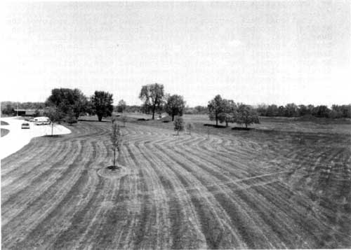 Figure 73: The golf-course turf management practices at Mound City Group sparked interpreters and park managers to contemplate the prehistoric Hopewellian landscape. (NPS/1974) |
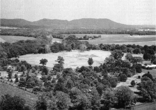 Figure 74: Aerial view of Mound City Group looking southeast, with reforestation having a noticeable impact on the landscape. (NPS/Brian Jones, Harpers Ferry Center, November 1978) |
In anticipation of reforestation, the 1961 growing season saw a substantial curtailment or elimination of mowing in specific areas. Before the forest could appear, however, managers agreed that the park's boundary had to be fenced. Initial plans for a hurricane fence were changed in 1961 to provide for a low, post-cable type fence primarily to prevent automobiles from leaving the highway and creating informal roads through the park. Once reforestation occurred, however, the fencing could be removed. In late 1962, plans changed again to have the fencing be a post-rail type. Foresters recommended that 1,600 trees cover a forty-acre area. Accelerated Public Works Program workers began the planting and fencing task in April 1963. Severe drought conditions took a tremendous toll on the 1,600 seedlings, while ten percent of 168 transplanted older trees perished. [31]
Estimates for achieving reforestation were revised in 1970. Exhausting available funds, Mound City Group purchased one thousand seedlings in February 1970 from the Division of Forestry and Reclamation, Ohio Department of Natural Resources. Seedlings numbered 250-each of green ash, red gum, white oak, and tuliptree. To continue the program, five thousand more seedlings were required. The effort came in a piecemeal fashion. In 1975, as part of a scouting project, a local troop planted one thousand hardwood seedlings on an acre of former lawn north of the entrance. Maple whip stock from other forested areas were also introduced in this area. [32]
This emphasis on reforestation was pursued without any scientific consideration of what the scene might have been two thousand years ago. Scholarship at the end of the twentieth century empasized natural prairie openings to a drastically modified environment, one of deforestation because of aboriginal agricultural practices. The emphasis reflected a pervasive Euro-American myth that America was wilderness prior to white colonization.
 Figure 75: Interpreters looked to Squier and Davis descriptions of trees and river gravel atop portions of the Mound City Group earthworks. A tree grows from a mound in the northeast corner. (NPS/circa 1975) |
More tree-planting took place in 1976 in areas east and west of the entrance road. More mature trees were taken from heavily wooded areas, and for the first time, archeologists monitored the ground disturbance for potential subsurface resources. The same year saw an operations evaluation team recommend a land use plan to realize once and for all the recreation of a "prehistoric scene." The idea originated by similar mounds maintenance issues at Effigy Mounds National Monument, Iowa, and the recognition that Mound City Group required similar technical assistance from regional landscape architects. Preliminary recommendations from Omaha essentially concurred that planting plans sanctioned in 1960 with the visitor center landscape and in the 1965 master plan be implemented. The monument invited public comment for comprehensive reforestation, which also included removing steps from Mound 7, the Death Mask Mound, obliterate all signs of former railroad grades, transferring the picnic area to a wooded area adjacent to the visitor center, and expand the trail system. [33]
Interpreters envisioned more than just trees surrounding the Mound City Group earthworks enclosure to make the landscape more realistic. To reflect the conditions known to exist in 1846, one key goal of the interpretive prospectus called for covering "certain mounds with pebbles as when originally constructed by Hopewells." Superintendent Fred Fagergren, Jr., enthusiastically made this interpretive goal into his own management objective in 1976, only to be met with a Midwest Archeological Center request to delay implementation pending further research. Acknowledging the maintenance dilemma inherent to his idea, Fagergren proposed restoring the pebble and gravel coverings, from eight to twenty inches thick, to eight mounds as described by Squier and Davis in Ancient Monuments of the Mississippi Valley. Fagergren argued that "Restoration of the mounds to a gravel and pebble surface will more accurately reflect the realities these people faced in construction of these monuments to their dead. While the present turf-covered mounds might be easier to maintain, they are not accurate reconstructions nor can they be interpreted as such." [34]
Fagergren's goal of restoring Mound City Group to historic 1846 conditions remained unfulfilled during his superintendency. It remained stalled because of a servicewide policy concerning reconstructions that mandated any physical changes to recapture elements from a previous era had to be based on a minimum of conjecture. Agency policy had matured since the 1960s when reconstruction efforts, including that at Mound City Group itself, could progress without intensive scrutiny by cultural specialists. Oftentimes the result of these ill-advised efforts produced scenes that strayed far from historical reality or authenticity. Under evolving historic preservation policies of the 1970s, radical changes to cultural resources such as reconstructions had to be based on substantial research and ultimately approved by the agency's director. In the absence of any concerted research into the actual characteristics of Mound City Group's Hopewellian appearance, management policy as determined by Washington, D.C., and implemented by regional Omaha agency officials required the status quo continue indefinitely.
Making the best of the situation, Fagergren issued a July 1980 policy directive instructing employees to help maintain the integrity of the historic scene in their everyday activities. In the "Historic Area" of the mounds enclosure, modern intrusions were to be kept to a minimum during primary visitation periods. Fagergren declared:
A substantial reduction in acreage being mowed has occurred compared to previous years, but not necessarily the smallest reduction possible. Policy calls for grass on the earthworks proper. The acreage within the wall is mowed in absence of research/data on the actual scene. Vistas are maintained for the Visitor Center from the highway and from the Visitor Center to earthworks. The extent of mowing mandates an intrusion by equipment. Mowing is not scheduled on weekends to remove the intrusion at least during that peak period. Research on the historic scene must occur; this data will affect and lessen the mowing practices....
Fagergren determined that other recreational uses could and should take place in these green, open vistas. He continued, stating:
The vista areas are the focal points for the other 'non-conforming recreational use.' Generally the earthworks do not experience this use. The large vistas are naturally inviting to an occasional frisbee, baseball or volleyball player. We strive to conform with policy by asking visitors to restrict these activities to the vista area west of the Visitor Center, and therefore out of the historic scene. The picnic area is also out of sight in the trees and does not intrude on the scene.
In conclusion, he informed his staff, we "can do little to more closely conform with policy until research has occurred and data are available on the historic scene." [35]
Programming for necessary research funds came about simultaneously with the new resource management plan in 1982. The proposed "prehistoric vegetation study" would include an archeological pollen study, analysis of faunal remains, charcoal analysis, and evaluation of soil samples taken from undisturbed areas. Observing that contemporary grass cover and forest succession conditions might or might not resemble the prehistoric period of Hopewell occupation, roughly 200 B.C. to 500 A.D., Ken Apschnikat stated, "All suppositions as to what vegetative conditions might have existed are scientifically unsupported hypotheses." [36]
Three different hypotheses circulated in the mid-1980s concerning the prehistoric landscape. The first held that before the Hopewell occupation and construction of Mound City Group, a prairie or savanna naturally maintained by fire existed with a narrow band of floodplain forest along the Scioto River. Following Indian occupation and the lack of fire episodes, hardwood forest took over. The second hypothesis determined that hardwood forest existed during the moundbuilding era and the Hopewell removed and kept trees from growing within the mound earthwall enclosure itself. The final hypothesis differed from the second only in that the Hopewell removed trees merely to construct charnel houses, mounds, walls, borrow pits, and potential vista areas. Otherwise, the forest prevailed. [37]
But even Apschnikat showed impatience at waiting for funding and initiated a new experiment by authorizing an expanded area in the northeast corner of the mounds be allowed to revegetate naturally during the 1986 growing season by removing it from regular mowing. He did so in order to demonstrate "the appearance... during Squier and Davis' time." [38]
Initial funding materialized in 1987 when a resource management specialist from Michigan's Pictured Rocks National Lakeshore, Dr. Walter Loope, began a literature search and interviews with archeologists to outline prehistoric vegetation compositions at both Mound City Group and Hopeton Earthworks. Resource managers recognized that based upon study results, contemporary maintenance practices could be reversed or lack of credible data could leave them with the status quo. In any case, Apschnikat believed his experiment in permitting tallgrass to exist next to manicured lawn simply gave visitors "another possible historic landscape for the mound area." [39]
Nineteen-eighty-nine represented a watershed year concerning traditional turf management practices at Mound City Group. The previous growing season had featured a lingering drought that browned and weakened an already stressed turf. Conditions were further exacerbated by construction activity for the new prison across State Highway 104 when the former agricultural fields began being infested with noxious weeds, seeds of which blew with prevailing winds onto monument lands. The result brought an aggressive invasion of unsightly weeds that threatened to overtake mowed areas unless prevented by chemicals and other expensive, labor-intensive actions. With this bleak scenario, a change in top park management came in late 1988.
Superintendent William Gibson took three months to assess the situation before making his bold announcement for a radical change of course. In a March 1989 memorandum to his subordinate division chiefs, Gibson shared his impression of the park's earthworks landscape management practices and shared with them knowledge gained from a cultural landscape management seminar sponsored by the Southeast Regional Office in Atlanta, Georgia. Gibson's attitudes were particularly influenced by an earthworks management manual developed in the Mid-Atlantic Region for Civil War-era landscapes. He suggested its approach be adopted as a model and operating guide. Because of funding limitations, the incorporation of an expanded Hopeton Earthworks, as well as proposals to add other Hopewell sites for NPS management, the time proved propitious for altering management practices at Mound City Group.
Recognizing that study results were still pending, Bill Gibson rejected outright the mowed appearance of the mounds. Gibson asserted:
...this golf course appearance in no way represents the appearance created by the Hopewell moundbuilders. With the most probable landscaping of the mound builders era being dense river bottom woodland, interspaced with human created slash and burn open spaces and/or naturally occurring patches of prairie grassland, neither scene is represented by our modern day turf lawn maintenance. More probable would be vast expanses of uncut forest interspaced with small, patchy woodland openings, created by arduous cutting with stone tools, and maintained using fire to burn debris. Such openings, containing stumps and downed timber, would quickly be overgrown by invading growth of weeds, vines and woody sprouts. With no domesticated grazing animals available, and no mechanical means other than the wear of daily foot traffic to keep down the brush, fire remains as the most likely management tool available to the moundbuilders. [40]
He concluded by ascertaining "the predictable result of such slash and burn land clearing, as well as that of naturally occurring patches of prairie grassland, is native tall grass ground cover." Gibson recommended the park's immediate resource management priority was to convert more turf to tall-grass native species and reduce the maintenance burden. [41]
Anticipating public inquiries or complaints as the grass continued to grow in early June 1989, Gibson prepared a briefing statement to help educate the public on the "Native Tall Grass Restoration" effort underway. Explaining the rationale behind the landscape changes, the statement acknowledged that turf maintenance efforts would only occur in core interpretive areas and walkways while the remaining open grounds would be encouraged to revert to native tall grass. Maintenance by controlled burning might be considered to either replace or complement periodic mowing. Change in habitat would also bring biological change and more diversity as native grass, wildflowers, and other native plants submerged bluegrass and common weeds. Thirteen-lined ground squirrels, discouraged by the tall grass, would go elsewhere, but groundhogs could increase. Field nesting birds like the bobolink would appear but so would hawk predators. Ticks and chiggers might discourage visitors from leaving mowed areas to explore the tall grass with the beneficial aspect of reduced foot traffic erosion, earthworks destruction, and enhanced archeological protection. Natural restoration would continue for two growing seasons, with the first cutting in the fall of 1990 accomplished with a tractor on flat areas and hand-carried brush cutters on the raised earthworks. [42]
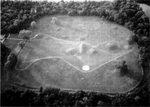 Figure 76: This aerial view plainly shows divergent turf managment practices within the Mound City Group, from mowed to tallgrass areas. (NPS/July 3, 1994) |
The native bluestem restoration area encompassed approximately nine acres of previously maintained lawn area in the Mound City Group earthworks. Thanks to the efforts of a vigilant interpretive staff, visitor reaction to the radical change proved "favorable and supportive." An interpretive handout designed to educate the public concerning the project also helped prevent any adverse public reaction. Interpreters reported the new appearance helped ease the task of recapturing a pre-twentieth century era as well as incorporating coverage of native plants and wildlife into their daily visitor contacts. [43]
With acquisition of Hopeton Earthworks in 1990, the tall grass restoration project shifted across the Scioto River. Previously cultivated areas were seeded with a mixture of switchgrass, Indian grass, and little bluestem, providing a quick, low maintenance cover to arrest erosion while at the same time rendering an "aesthetically pleasing" look. Problems at both areas in 1991 centered on an infestation of Canada thistle. With manual removal proving ineffective, managers selected periodic mowing as a means to check the pesky exotic. [44]
A contract to provide the long-promised prehistoric vegetation study, while let in 1988, did not yield a final product until the spring of 1991. Preliminary data, however, became known as early as 1989 and served to validate the management actions taken by Bill Gibson. In July 1988, Dr. Ronald O. Kapp of Alma College, and Gordon G. Snyder of Schoolcraft College, both in Michigan, took a series of sedimentary core samples from area ponds. From these murky depths, the researchers discovered undisturbed sediment from which pollen analysis could determine area vegetation patterns over the course of centuries. Their final report determined that "the extent of open, non-forest vegetation was considerably greater prior to ca. 2000 B.C. than after." During the early stages of the Hopewell culture, the area experienced a "transition from a more open to a more forested environment." [45]
The report seemed to contradict efforts to restore an open, prairie-like environment. For the first time, park managers had scientific data to make landscape management decisions. The data put into question the tall grass restoration launched by Bill Gibson in 1989. Working behind the scenes to formulate long-term management strategies were H. Reed Johnson, chief of interpretation and resource management, and Steve Cinnamon, resource management specialist in Omaha. [46]
Ironically, the goal of recreating a Hopewellian cultural landscape predated the birth of an aggressive cultural landscape program in established in the Midwest Region. With the arrival in Omaha of Regional Historical Landscape Architect Mary V. Hughes in January 1991, the changed cultural landscape at Mound City Group, the subject of heated debate for decades, was already taking firm root in the Chillicothe soil. With the ascendancy of historical landscapes within cultural resources management, the 1997 general management plan calls for a cultural landscape report to guide development within all five units of Hopewell Culture National Historical Park.
| <<< CHAPTER 8 | TABLE OF CONTENTS | CHAPTER 10 >>> |