![]()
Cover Page
MENU
Presidential Statement
Foreword
Preface
|
Yellowstone National Park: Its Exploration and Establishment Part II: Definitive Knowledge |

|

Hayden Survey camp, Yellowstone Lake, 1871, by William Henry
Jackson.
(U.S. Geological Survey)
The Folsom Party (1869)
Fifty-three years later Cook recalled that start, and the attitude with which friends viewed their venture, quoting thus from his diary:
The long-talked-of expedition to the Yellowstone is off at last but shorn of the prestige attached to the names of a score of the brightest luminaries in the social firmament of Montana, as it was first announced. It has assumed proportions of utter insignificance, and of no importance to anybody in the world except the three actors themselves. Our leave-taking from friends who had assembled to see us start this morning was impressive, in the highest degree and rather cheering withal. "Good-bye, boys, look out for your hair." "If you get into a scrap, remember I warned you." "If you get back at all you will come on foot." "It is the next thing to suicide," etc. etc., were the parting salutations that greeted our ears as we put spurs to our horses and left home and friends behind. [8]
Following their return from the Yellowstone region these explorers were reluctant to prepare an account of what they had seen, for, as Folsom later commented, "I doubted if any magazine editor would look upon a truthful description in any other light than the production of the too-vivid imagination of a typical Rocky Mountain liar." [9] However, they soon received an encouragement which was irresistible. According to Cook, it happened this way:
Soon after my return from the trip of 1869, I received a letter from Mr. Clark, a friend whom I had met the previous year, stating that he had read that an expedition to the source of the Yellowstone and Madison rivers had been contemplated, and, supposing of course that I was with it, wanted to know what we had discovered. I at once answered this letter, giving him some idea of our trip and discoveries. He at once replied and asked for a writeup of all details. I then took the matter up with Mr. Folsom and, as we had not much to do that winter at the "Ditch Company," we prepared an amplified diary by working over both the diaries made on the trip, and combining them into one. . . . Mr. Folsom then added to this diary a preliminary statement, and I forwarded the same to Mr. Clark. He wrote back at once asking my permission to have it published to which request we gave our consent. Later I received a letter from Mr. Clark stating that he had made an effort to have our amplified diary published in the New York Tribune, and also in Scribner's or Harper's magazines, but both refused to consider it for the reason that "they had a reputation that they could not risk with such unreliable material." Finally, he secured its publication in the Western Monthly Magazine, published at Chicago, Illinois, and received, as a compensation, the sum of $18.00. The condition in which this amplified diary appeared in the June number of the Western Monthly Magazine was neither the fault of Mr. Folsom nor myself, as the editor cut out portions of the diary which destroyed its continuity, so far as giving a reliable description of our trip and the regions explored.
In the original article, I alone, was credited with writing the article, but later, when a reprint was made of it by N. P. Langford, he credited it to D. E. Folsom, neither of which are correct. We did not sign the diary sent to Mr. Clark, and, as he did not know Mr. Folsom but had carried on the correspondence with me, he had it credited to me; but the actual facts are as above outlined. [10]
David E. Folsom, Charles W. Cook, and William Peterson left Diamond City, Mont., on September 6, 1869, traveling with saddle and pack animals to the Gallatin Valley. At the town of Bozeman, where they obtained provisions, an attempt was made to recruit some of the townsmen into their enterprise, but without success; however, they did receive some valuable information from George Phelps, one of the prospectors who had returned through the Yellowstone region following the breakup of James Stuart's expedition down the Yellowstone River and into the Wyoming Basin in 1864. From Bozeman the three explorers took the miner's route, by way of Meadow and Trail Creeks, to the Yellowstone River nearly opposite Emigrant Gulch. The account is continued from that point mainly with excerpts from the Cook-Folsom article as it appeared in 1870. [11]
We pushed on up the valley, following the general course of the river as well as we could, but frequently making short detours through the foot-hills, to avoid the deep ravines and places where the hills terminated abruptly at the water's edge. On the eighth day out, we encountered a band of Indians—who, however, proved to be Tonkeys, or Sheepeaters, and friendly; the discovery of their character relieved our minds of apprehension, and we conversed with them as well as their limited knowledge of English and ours of pantomine would permit. [12] For several hours after leaving them, we travelled over a high rolling table-land, diversified by sparkling lakes, picturesque rocks, and beautiful groves of timber. Two or three miles to our left, we could see the deep gorge which the river, flowing westward, had cut through the mountains. [13] The river soon after resumed its northern course; and from this point to the falls, a distance of twenty-five or thirty miles, it is believed to flow through one continuous cañon, through which no one has ever been able to pass. [14]
At this point we left the main river, intending to follow up the east branch for one day, then to turn in a southwest course and endeavor to strike the river again near the falls. After going a short distance, we encountered a cañon about three miles in length, and while passing around it we caught a glimpse of scenery so grand and striking that we decided to stop for a day or two and give it a more extended examination. [15] We picked our way to a timbered point about mid-way of the cañon, and found ourselves upon the verge of an overhanging cliff at least seven hundred feet in height. The opposite bluff was about on a level with the place where we were standing; and it maintained this height for a mile up the river, but gradually sloped away toward the foot of the cañon. The upper half presented an unbroken face, with here and there a re-entering angle, but everywhere maintained its perpendicularity; the lower half was composed of the debris that had fallen from the wall. But the most singular feature was the formation of the perpendicular wall. At the top, there was a stratum of basalt, from thirty to forty feet thick, standing in hexagonal columns;. beneath that, a bed of conglomerate eighty feet thick, composed of washed gravel and boulders; then another stratum of columnar basalt of about half the thickness of the first; and lastly what appeared to be a bed of coarse sandstone. A short distance above us, rising from the bed of the river, stood a monument or pyramid of conglomerate, circular in form, which we estimated to be forty feet in diameter at the base, and three hundred feet high, diminishing in size in a true taper to its top, which was not more than three feet across. It was so slender that it looked as if one man could topple it over. How it was formed I leave others to conjecture. [16] We could see the river for nearly the whole distance through the cañon dashing over some miniature cataract, now fretting against huge boulders that seemed to have been hurled by some giant hand to stay its progress, and anon circling in quiet eddies beneath the dark shadows of some projecting rock. The water was so transparent that we could see the bottom from where we were standing, and it had that peculiar liquid emerald tinge so characteristic of our mountain streams.
Half a mile down the river, and near the foot of the bluff, was a chalky-looking bank, from which steam and smoke were rising; and on repairing to the spot, we found a vast number of hot sulphur springs. [17] The steam was issuing from every crevice and hole in the rocks; and, being highly impregnated with sulphur, it threw off sulphuretted hydrogen, making a stench that was very unpleasant. All the crevices were lined with beautiful crystals of sulphur, as delicate as frost-work. At some former period, not far distant, there must have been a volcanic eruption here. Much of the scoria and ashes which were then thrown out has been carried off by the river, but enough still remains to form a bar, seventy-five or a hundred feet in depth. Smoke was still issuing from the rocks in one place, from which a considerable amount of lava had been discharged within a few days or weeks at farthest. While we were standing by, several gallons of a black liquid ran down and hardened upon the rocks; we broke some of this off and brought it away, and it proved to be sulphur, pure enough to burn readily when ignited. [18]
Reference to the reconstructed account (1965, pp. 26-29) shows that the editor of the Western Monthly cut out that portion of the original manuscript covering the crossing of Yellowstone River, the journey up Lamar River to the mouth of Calfee Creek, and the ascent of Flint Creek to a storm-bound encampment below the rim of Mirror Plateau. The magazine account resumes at that point:
September 1 8th—the twelfth day out—we found that ice had formed one-fourth of an inch thick during the night, and six inches of snow had fallen. The situation began to look a little disagreeable; but the next day was bright and clear, with promise of warm weather again in a few days. Resuming our journey, we soon saw the serrated peaks of the Big Horn Range glistening like burnished silver in the sunlight, and, over-towering them in the dim distance, the Wind River Mountains seemed to blend with the few fleecy clouds that skirted their tops; [19] while in the opposite direction, in contrast to the barren snow-capped peaks behind us, as far as the eye could reach, mountain and valley were covered with timber, whose dark green foliage deepened in hue as it receded, till it terminated at the horizon in a boundless black forest. Taking our bearings as well as we could, we shaped our course in the direction in which we supposed the falls to be.
The next day (September 20th), we came to a gentle declivity at the head of a shallow ravine, from which steam rose in a hundred columns and united in a cloud so dense as to obscure the sun. In some places it spurted from the rocks in jets not larger than a pipe-stem; in others it curled gracefully up from the surface of boiling pools from five to fifteen feet in diameter. In some springs the water was clear and transparent; others contained so much sulphur that they looked like pots of boiling yellow paint. One of the largest was as black as ink. Near this was a fissure in the rocks, several rods long and two feet across in the widest place at the surface, but enlarging as it descended. We could not see down to any great depth, on account of the steam but the ground echoed beneath our tread with a hollow sound, and we could hear the waters surging below, sending up a dull, resonant roar like the break of the ocean surf into a cave. At these springs but little water was discharged at the surface, it seeming to pass off by some subterranean passage. About half a mile down the ravine, the springs broke out again. Here they were in groups, spreading out over several acres of ground. One of these groups—a collection of mud springs of various colors, situated one above the other on the left slope of the ravine—we christened "The Chemical Works." [20] The mud, as it was discharged from the lower side, gave each spring the form of a basin or pool. At the bottom of the slope was a vat, ten by thirty feet, where all the ingredients from the springs above were united in a greenish-yellow compound of the consistency of white lead. Three miles further on we found more hot springs along the sides of a deep ravine, at the bottom of which flowed a creek twenty feet wide. [21] Near the bank of the creek, through an aperture four inches in diameter, a column of steam rushed with a deafening roar, with such force that it maintained its size for forty feet in the air, then spread out and rolled away in a great cloud toward the heavens. We found here inexhaustible beds of sulphur and saltpetre. Alum was also abundant; a small pond in the vicinity, some three hundred yards long and half as wide, contained as much alum as it could hold in solution, and the mud along the shore was white with the same substance, crystallized by evaporation.
On September 21st, a pleasant ride of eighteen miles over an undulating country brought us to the great cañon, two miles below the falls; [22] but there being no grass convenient, we passed on up the river to a point half a mile above the upper falls, and camped on a narrow flat, close to the river bank. [23] We spent the next day at the falls—a day that was a succession of surprises; and we returned to camp realizing as we had never done before how utterly insignificant are man's mightiest efforts when compared with the fulfillment of Omnipotent will. Language is entirely inadequate to convey a just conception of the awful grandeur and sublimity of this masterpiece of nature's handiwork; and in my brief description I shall confine myself to bare facts. Above our camp the river is about one hundred and fifty yards wide, and glides smoothly along between gently-sloping banks; but just below, the hills crowd in on either side, forcing the water into a narrow channel, through which it hurries with increasing speed, until, rushing through a chute sixty feet wide, it falls in an unbroken sheet over a precipice one hundred and fifteen feet in height. [24] It widens out again, flows with steady course for half a mile between steep timbered bluffs four hundred feet high, and again narrowing in till it is not more than seventy-five feet wide, it makes the final fearful leap of three hundred and fifty feet. [25] The ragged edges of the precipice tear the water into a thousand streams—all united together, and yet apparently separate,—changing it to the appearance of molten silver; the outer ones decrease in size as they increase in velocity, curl outward, and break into mist long before they reach the bottom. This cloud of mist conceals the river for two hundred yards, but it dashes out from beneath the rainbow-arch that spans the chasm, and thence, rushing over a succession of rapids and cascades, it vanishes at last, where a sudden turn of the river seems to bring the two walls of the cañon together. Below the falls, the hills gradually increase in height for two miles, where they assume the proportions of mountains. Here the cañon is at least fifteen hundred feet deep, with an average width of twice that distance at the top. For one-third of the distance downwards the sides are perpendicular,—from thence running down to the river in steep ridges crowned by rocks of the most grotesque form and color; and it required no stretch of the imagination to picture fortresses, castles, watch-towers, and other ancient structures, of every conceivable shape. In several places near the bottom, steam issued from the rocks; and, judging from the indications, there were at some former period hot springs or steam-jets of immense size all along the wall.
The next day we resumed our journey, traversing the northern slope of a high plateau between the Yellowstone and Snake Rivers. [26] Unlike the dashing mountain—stream we had thus far followed, the Yellowstone was in this part of its course wide and deep, flowing with a gentle current along the foot of low hills, or meandering in graceful curves through broad and grassy meadows. Some twelve miles from the falls we came to a collection of hot springs that deserve more than a passing notice. These, like the most we saw, were situated upon a hillside; and as we approached them we could see the steam rising in puffs at regular intervals of fifteen or twenty seconds, accompanied by dull explosions which could be heard half a mile away, sounding like the discharge of a blast underground. These explosions came from a large cave that ran back under the hill, [27] from which mud had been discharged in such quantities as to form a heavy embankment twenty feet higher than the floor of the cave, which prevented the mud from flowing off; but the escaping steam had kept a hole, some twenty feet in diameter, open up through the mud in front of the entrance to the cave. The cave seemed nearly filled with mud, and the steam rushed out with such volume and force as to lift the whole mass up against the roof and dash it out into the open space in front; and then, as the cloud of steam lifted, we could see the mud settling back in turbid waves into the cavern again. Three hundred yards from the mud-cave was another that discharged pure water; the entrance to it was in the form of a perfect arch, seven feet in height and five in width. [28] A short distance below these caves were several large sulphur springs, the most remarkable of which was a shallow pool seventy-five feet in diameter, in which clear water on one side and yellow mud on the other were gently boiling without mignling.
September 24th we arrived at Yellowstone Lake, [29] about twenty miles from the falls. The main body of this beautiful sheet of water is ten miles wide from east to west, and sixteen miles long from north to south; but at the south end it puts out two arms, one to the southeast and the other to the southwest, making the entire length of the lake about thirty miles. Its shores—whether gently sloping mountains, bold promontories, low necks, or level prairies—are everywhere covered with timber. The lake has three small islands, which are also heavily timbered. The outlet is at the northwest extremity. The lake abounds with trout, and the shallow water in its coves affords feeding ground for thousands of wild ducks, geese, pelicans, and swans.
We ascended to the head of the lake, [30] and remained in its vicinity for several days, resting ourselves and our horses, and viewing the many objects of interest and wonder. Among these were springs differing from any we had previously seen. They were situated along the shore for a distance of two miles, extending back from it about five hundred yards and into the lake perhaps as many feet. The ground in many places gradually sloped down to the water's edge, while in others the white chalky cliffs rose fifteen feet high—the waves having worn the rock away at the base, leaving the upper portion projecting over in some places twenty feet. There were several hundred springs here, varying in size from miniature fountains to pools or wells seventy-five feet in diameter and of great depth; the water had a pale violet tinge, and was very clear, enabling us to discern small objects fifty or sixty feet below the surface. In some of these, vast openings led off at the side; and as the slanting rays of the sun lit up these deep caverns, we could see the rocks hanging from their roofs, their water-worn sides and rocky floors, almost as plainly as if we had been traversing their silent chambers. These springs were intermittent, flowing or boiling at irregular intervals. The greater portion of them were perfectly quiet while we were there, although nearly all gave unmistakable evidence of frequent activity. Some of them would quietly settle for ten feet, while another would as quietly rise until it overflowed its banks, and send a torrent of hot water sweeping down to the lake. At the same time, one near at hand would send up a sparkling jet of water ten or twelve feet high, which would fall back into its basin, and then perhaps instantly stop boiling and quietly settle into the earth, or suddenly rise and discharge its waters in every direction over the rim; while another, as if wishing to attract our wondering gaze, would throw up a cone six feet in diameter and eight feet high, with a loud roar. These changes, each one of which would possess some new feature, were constantly going on; sometimes they would occur within the space of a few minutes, and again hours would elapse before any change could be noted. At the water's edge, along the lake shore, there were several mounds of solid stone, on the top of each of which was a small basin with a perforated bottom; these also overflowed at times, and the hot water trickled down on every side. Thus, by the slow process of precipitation, through the countless lapse of ages, these stone monuments have been formed. A small cluster of mud springs near by claimed our attention. [31] They were like hollow truncated cones and oblong mounds, three or four feet in height. These were filled with mud, resembling thick paint of the finest quality—differing in color, from pure white to the various shades of yellow, pink, red, and violet. Some of these boiling pots were less than a foot in diameter. The mud in them would slowly rise and fall as the bubbles of escaping steam, following one after the other, would burst upon the surface. During the afternoon, they threw mud to the height of fifteen feet for a few minutes, and then settled back to their former quietude.
As we were about departing on our homeward trip, we ascended the summit of a neighboring hill, and took a final look at Yellowstone Lake. Nestled among the forest-crowned hills which bounded our vision, lay this inland sea, its crystal waves dancing and sparkling in the sunlight, as if laughing with joy for their wild freedom. It is a scene of transcendent beauty, which has been viewed by but few white men; and we felt glad to have looked upon it before its primeval solitude should be broken by the crowds of pleasure-seekers which at no distant day will throng its shores. [32]
September 29th, we took up our march for home. Our plan was to cross the range in a northwesterly direction, find the Madison River, and follow it down to civilization. Twelve miles brought us to a small triangular-shaped lake, about eight miles long, deeply set among the hills. [33] We kept on in a northwesterly direction, as near as the rugged nature of the country would permit; and on the third day (October 1st) came to a small irregularly shaped valley, some six miles across in the widest place, from every part of which great clouds of steam arose. From descriptions which we had had of this valley, from persons who had previously visited it, we recognized it as the place known as "Burnt Hole," or "Death Valley." The Madison River flows through it, and from the general contour of the country we knew that it headed in the lake which we passed two days ago, [34] only twelve miles from the Yellowstone. We descended into the valley, and found that the springs had the same general characteristics as those I have already described, although some of them were much larger and discharged a vast amount of water. One of them, at a little distance, attracted our attention by the immense amount of steam it threw off; and upon approaching it we found it to be an intermittent geyser in active operation. [35] The hole through which the water was discharged was ten feet in diameter, and was situated in the centre of a large circular shallow basin, into which the water fell. There was a stiff breeze blowing at the time, and by going to the windward side and carefully picking our way over convenient stones, we were enabled to reach the edge of the hole. At that moment the escaping steam was causing the water to boil up in a fountain five or six feet high. It stopped in an instant, and commenced settling down—twenty, thirty, forty feet—until we concluded that the bottom had fallen out; but the next instant, without any warning, it came rushing up and shot into the air at least eighty feet, causing us to stampede for higher ground. It continued to spout at intervals of a few minutes, for some time; but finally subsided, and was quiet during the remainder of the time we stayed in the vicinity. We followed up the Madison five miles, and there found the most gigantic hot springs we had seen. They were situated along the river bank, and discharged so much hot water that the river was blood-warm a quarter of a mile below. One of the springs was two hundred and fifty feet in diameter, and had every indication of spouting powerfully at times. [36] The waters from the hot springs in this valley, if united, would form a large stream; and they increase the size of the river nearly one-half. Although we experienced no bad effects from passing through the "Valley of Death," yet we were not disposed to dispute the propriety of giving it that name. [37] It seemed to be shunned by all animated nature. There were no fish in the river, no birds in the trees, no animals—not even a track—anywhere to be seen; although in one spring we saw the entire skeleton of a buffalo that had probably fallen in accidentally and been boiled down to soup.
Leaving this remarkable valley, we followed the course of the Madison—sometimes through level valleys, and sometimes through deep cuts in mountain ranges,—and on the fourth of October emerged from a cañ, ten miles long and with high and precipitous mountain sides, to find the broad valley of the Lower Madison spread out before us. Here we could recognize familiar landmarks in some of the mountain peaks around Virginia City. From this point we completed our journey by easy stages, and arrived at home on the evening of the eleventh. We had been absent thirty-six days—a much longer time than our friends had anticipated;—and we found that they were seriously contemplating organizing a party to go in search of us.
Nathaniel P. Langford deprecated the importance of the foregoing Cook-Folsom article, stating:
The office of the Western Monthly, of Chicago, was destroyed by fire soon after the publication of Mr. Folsom's account of his discoveries, and the only copy of that magazine which he possessed, and which he presented to the Historical Society of Montana, met a like fate in the great Helena fire. The copy which I possess is perhaps the only one to be found. [38]
However, the office of the Western Monthly, or the Lakeside Monthly as it was called after 1870, was destroyed in the Chicago fire of October 3-9, 1871, so that subscribers had the July 1870 issue for well over a year prior to that holocaust, and it is not as rare as Langford supposed.
There is no way to judge the impact of the Cook-Folsom article, but there is evidence that the information brought back by the Folsom party of 1869 was influential in launching the Washburn party of 1870. N. P. Langford has testified to the inspirational value of this exploration in the following words:
On his return to Helena he [Folsom] related to a few of his intimate friends many of the incidents of his journey, and Mr. Samuel T. Hauser and I invited him to meet a number of the citizens of Helena at the director's room of the First National Bank in Helena; but on assembling there were so many present who were unknown to Mr. Folsom that he was unwilling to risk his reputation for veracity, by a full recital, in the presence of strangers, of the wonders he had seen. He said that he did not wish to be regarded as a liar by those who were unacquainted with his reputation. But the accounts which he gave to Hauser, Gillette and myself renewed in us our determination to visit that region during the following year. [39]
But encouragement was not the whole of Folsom's assistance to the Washburn party; he also provided geographical information. Soon after his return from the Yellowstone wilderness, Folsom took employment in the Helena office of the new Surveyor-General of Montana Territory, Henry D. Washburn. There,, he worked with that other civil engineer and Yellowstone explorer, Walter W. deLacy, and together they turned out a noteworthy map.
This map, [40] which is endorsed over the signature of Commissioner Joseph S. Wilson of the General Land Office as "accompanying Commissioner's s Annual Report for 1869," was dated at Helena, Mont., November 1, 1869—a mere 21 days after the return of the Folsom party to Diamond City. On it, the Yellowstone region was revealed in greater detail than ever before, and its portrayal was, at last, reasonably accurate (see map 9.). The "Route of Messrs Cook & Folsom 1869" was shown, and along that track, such prominent features as "Gardner's River," with its "Hot Spgs" (Mammoth Hot Springs); the "East Fork," now Lamar River, with "Burning Spring" (Calcite Springs) near its mouth; "Alum Creek" and some thermal features on Broad Creek; the falls of the Yellowstone (the upper noted as "115 ft." and the lower as "350 ft."); "Hot Spgs." noted at the Crater Hills and on Trout Creek, and a "Mud Spring" nearer the outlet of Yellowstone Lake (the Mud Volcano area). The lake was shown as a two-armed body of water, with a "Main Fork" (Upper Yellowstone River) discharging into the large, southern arm, and "Hot Spgs" on the west shore of the bulbous western arm. Interestingly, three islands were clearly shown in the lake (Stevenson, Dot, and Frank), and "Hot Springs" were noted on a point on the northeastern shore (Steamboat Point), and near Pelican Creek.
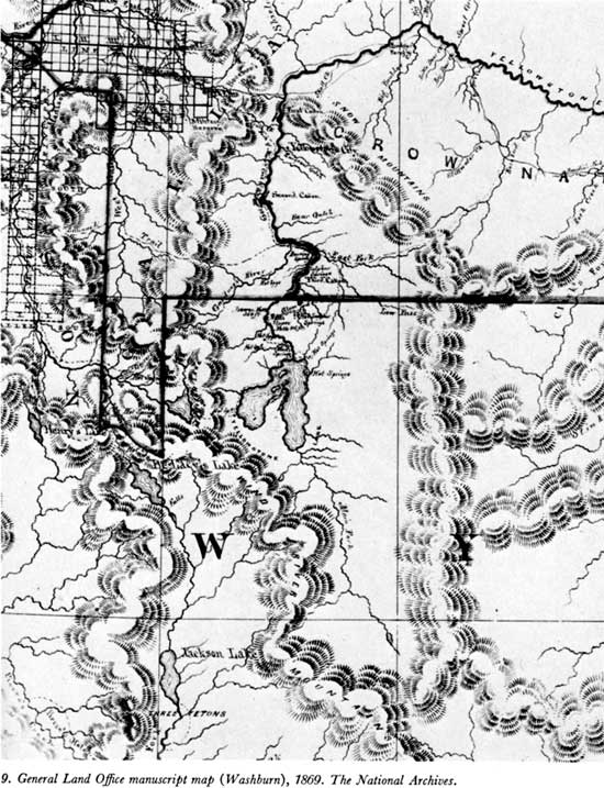
A new feature added by these explorers was a triangular "Madison Lake," placed west of Yellowstone Lake in accordance with their experience of coming down on the east shore of a large lake after traveling westward from the hot springs at West Thumb. This lake was not recognized for what it was—"Delacy's" or Shoshone Lake—because of an accumulation of mapping errors. Most Yellowstone features are positioned 15 or more miles too far to the west on this General Land Office map, and 11 to 20 miles too far to the north, when compared with present-day maps. However, "DeLacy's Lake," although similarly misplaced in its longitude, is shown only 2 miles north of the correct latitude for its outlet. [41] Thus, when the Folsom party found a large lake nearly 20 miles north of the map position of deLacy's, they failed to relate the two and added a lake which they presumed to be the head of the Madison River, hence its name.
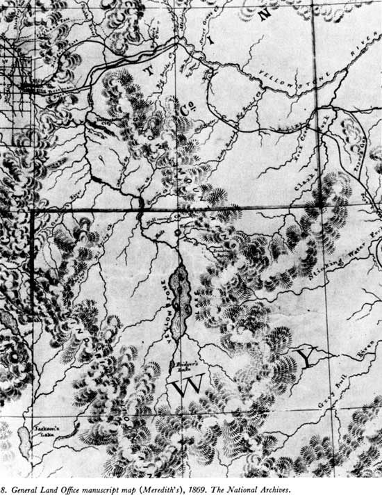
On the Madison River, "Hot Springs" were shown at the head of its southern branch (Firehole River), and both "Hot Springs" and "Geysers" where the eastern branch—presumed to drain "Madison Lake"—joined the former stream. Except for the inconsistencies caused by the introduction of the fictitious "Madison Lake," and omission of Heart Lake and the headwaters of Snake River, the Cook-Folsom information had produced a reasonably good map. How much better it was than the map it superseded [42] is evident at a glance (see map 8).
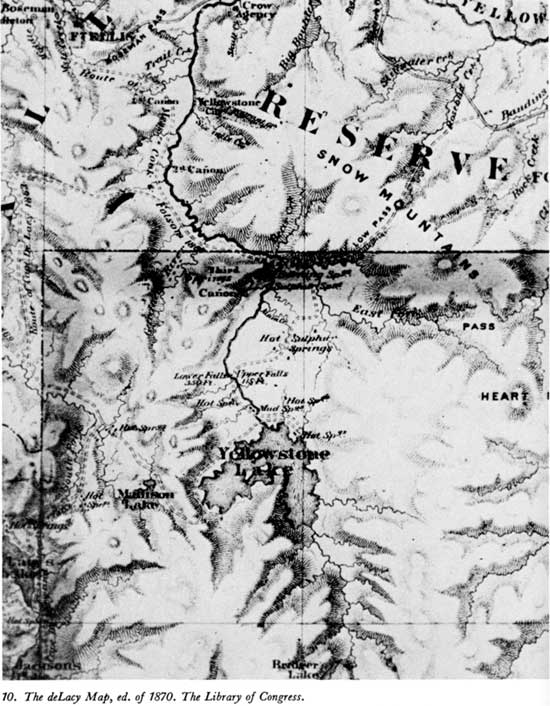
The information brought back by the Folsom party soon appeared in another form of greater importance than the General Land Office map because of its wider distribution and the fact that a copy was carried through the Yellowstone region by the Washburn party of 1870. A comparison (see map 10), shows that this map had profited from the same improvements apparent on the 1869 General Land Office map, and the usefulness of this 1870 edition of the deLacy map to the Yellowstone explorers of that year is mentioned by Oscar O. Mueller, who says:
Naturally after their return from the exploration trip, they [Cook and Folsom] gave the Surveyor General's Office every possible information they could regarding the region explored and what they had found. W. W. deLacy was employed by the Territory to prepare maps and, therefore, with the assistance of Mr. Folsom, prepared a new map of the Territory of Montana, showing also the north half of the Wyoming Territory. These maps were printed . . . [and] General Washburn took with him, on his exploration trip to the Yellowstone region in 1870, one of these maps and also a copy of the diary of Mr. Cook and Folsom. It can be readily seen, from the inspection of the map covering the Yellowstone region, how valuable an assistance it was to the 1870 expedition. Washburn and Langford were advised to seek a short cut from Tower Falls to the Yellowstone Canyon and Falls. It was this that made General Washburn leave the party at Tower Falls on a Sunday afternoon, and ride up to the top of what is now known as Mount Washburn, from which he could see that the short cut was feasible, and thus they deviated at that point from the route followed by Cook and Folsom in 1869. [44]
While yet employed in the surveyor-general's office—Langford says it was "on the eve of the departure of our expedition from Helena" [45]—Folsom suggested to General Washburn that at least a part of the Yellow stone region should be made into a park. [46]
The contributions of the Folsom party of 1869 to the definitive exploration of the Yellowstone region are these: a descriptive magazine article, a greatly improved map, a suggestion for reservation in the public interest, and the encouragement of the Washburn party of explorers.
Top
Last Modified: Tues, Jul 4 2000 07:08:48 am PDT
http://www.cr.nps.gov/history/online_books/haines1/iee2b.htm
![]()