![]()
Cover Page
MENU
Presidential Statement
Foreword
Preface
|
Yellowstone National Park: Its Exploration and Establishment Part I: Early Knowledge |

|
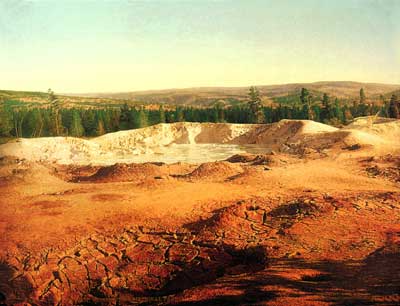
Paint pots, 1902, by William
Henry Jackson.
(Yellowstone National Park)
The Exploring Era (1851-63)
Between the fur trade and prospecting eras is a brief period of missionary and military exploration which advanced the general knowledge of the Yellowstone region without any actual penetration of its fastnesses. Through their maps and writings these explorers became the means of preserving an important residual from that store of accurate geographical information amassed by the men of the fur trade. The fact that Jim Bridger provided most of the information set on paper by intelligent, perceptive men testifies to the good repute in which his serious utterances were held.
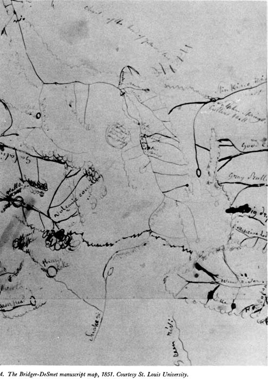
Bridger was present in 1851 at the great treaty council held at Fort Laramie to secure the emigrant road from Indian molestation, and, while there, he made a map for the Jesuit priest, Father Pierre-Jean DeSmet, which showed the streams heading in and around the Yellowstone region. [71] Bridger's remarkable map set the missionary-explorer straight on the rumors he had heard in 1839 concerning manifestations of volcanism on the headwaters of the Missouri River, [72] allowing him to add important details to his manuscript map. [73]
The Bridger map is essentially a hydrographic sketch of amazing accuracy when one accepts its lack of scale. Two Ocean Pass is indicated by the meeting of Atlantic and Pacific Creeks (both named), and the ultimate sources of the upper Yellowstone River are shown as originating on the flank of the Absaroka Range opposite Wind River. An oval Yellowstone Lake—unnamed but containing the notation "60 by 7"—has "Hot Springs" noted on its eastern shore (Steamboat Point) and "Volcano" near its outlet (Mud Geyser Area). The Grand Canyon of the Yellowstone is indicated by a crinkled outline, with "Falls 250 Feet" at its upper end and a ford below—shown by a heavy pen stroke across the river. The Lamar River, marked "Meadow", is shown with its feeder streams nestled against the Absaroka Range, and north of it a short stream marked "Beaver" (Slough Creek) terminates in a lake (Abundance). The prominant leftward trend of the Yellowstone River from its junction with the Lamar is shown, and farther down the rightward swing, as the river turns back toward a north course, is indicated. "Gardener's Cr." is shown entering at the latter point, and on its west bank is a "Sulphur Mtn." (Mammoth Hot Springs).
The presentation of the "Madison" and "Gallatin" headwaters of the Missouri River suffers from being cramped. A mass of pen curls on both the southern and northern branches of the Madison appear to represent the Firehole and Norris thermal areas, with the notation "volcanic country" between them. Centered in the triangle formed by Yellowstone Lake, the mouth of Lamar River, and the head of Gibbon River is a circled notation "Great Volcanic Country 100 miles in extent." Of particular importance beyond the Yellowstone Plateau is the notation at the forks of the "Stinking River" (Shoshone): "Sulphur Springs Colter's Hell."
Such was Bridger's own delineation of the Yellowstone region, with names added by DeSmet (see map 4). Most of that information was transferred to DeSmet's manuscript map, but there are some changes and additions worthy of mention. At Two Ocean Pass, he added a short "Two Ocean Rv." (recognizable as Two Ocean Creek, the stream which flows from the mountains into the pass to split into Atlantic and Pacific creeks), and, on the upper Yellowstone River, he added a "Bridger's Lake & Riv." (both misplaced). The DeSmet manuscript map names Yellowstone Lake, retaining the notation concerning its size, but omits both the outline of the Grand Canyon and the reference to the falls at its upper end; however, a name—"Little Falls"—appears at just the right place to represent Tower Fall. Lamar River is mislabeled "Beaver Creek" (it was "Meadow" on Bridger's map), and the Slough Creek and Hellroaring drainages were omitted.
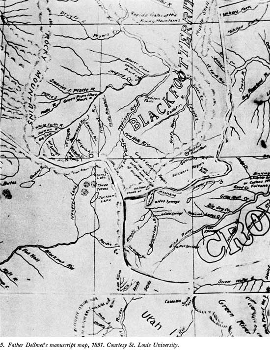
But it was in presenting the headwaters of the Madison River that DeSmet deviated most from Bridger's information. The eastward-trending branch is named "Fire Hole Riv.," while a southern branch, passing through two small lakes, is shown as "DeSmet's L. and Riv." This latter addition appears to portray the Lewis-Shoshone system, but with its river flowing to the Madison rather than Snake River (see map 5).
The changes which appear on DeSmet's manuscript map may represent additional information received in oral form from Bridger, or they may have come from an entirely different source, but the result was so much better than the best maps available to the Indian commissioners that he was asked to prepare a general map suitable for their purpose—an outcome which he explains thus:
When I was at the council ground in 1851, on the Platte River, at the mouth of Horse creek, I was requested by Colonel Mitchell to make a map of the whole Indian country, relating particularly to the Upper Missouri, the waters of the upper Platte, east of the Rocky mountains and of the headwaters of the Columbia and its tributaries west of these mountains. In compliance with this request I drew up the map from scraps then in my possession. The map, so prepared, was seemingly approved and made use of by the gentlemen assembled in council, and subsequently sent on to Washington together with the treaty then made with the Indians. [74]
In a letter written from the council grounds to his superiors, DeSmet describes the Yellowstone thermal features as follows: [75]
Near the source of the river Puante [Stinking Water, now called Shoshone] which empties into the Big Horn, and the sulphurous waters of which have probably the same medicinal qualities as the celebrated Blue Lick Springs of Kentucky, is a place called Colter's Hell—from a beaver hunter of that name. This locality is often agitated with subterranean fires. The sulphurous gases which escape in great volumes from the burning soil infect the atmosphere for several miles, and render the earth so barren that even the wild worm wood cannot grow on it. The beaver hunters have assured me that the frequent underground noises and explosions are frightful.
However, I think that the most extraordinary spot in this respect, and perhaps the most marvelous of all the northern half of this continent, is in the very heart of the Rocky Mountains, between the forty-third and forty-fifth degrees of latitude and 109th and 11th degrees of longitude, that is, between the sources of the Madison and Yellowstone. It reaches more than a hundred miles. Bituminous, sulphurous and boiling springs are very numerous in it. The hot springs contain a large quantity of calcareous matter [silicious], and form hills more or less elevated, which resemble in their nature, perhaps, if not in their extent, the famous springs of Pambuk Kalessi, in Asia Minor, so well described by Chandler [Richard Chandler, English Archaeologist, 1738-1810]. The earth is thrown up very high, and the influence of the elements causes it to take the most varied and the most fantastic shapes. Gas, vapor and smoke are continually escaping by a thousand openings, from the base to the summit of the volcanic pile; the noise at times resembles the steam let off by a boat. Strong subterranean explosions occur, like those in 'Colter's Hell'. The hunters and Indians speak of it with a superstitious fear, and consider it the abode of evil spirits, that is to say, a kind of hell. Indians seldom approach it without offering some sacrifice, or at least without presenting the calumet of peace to the turbulent spirits, that they may be propitious. They declare that the subterranean noises proceed from the forging of warlike weapons: each eruption of earth is, in their eyes, the result of a combat between the infernal spirits, and becomes a monument of a new victory or calamity. [76]
Near Gardiner river, a tributary of the Yellowstone, and in the vicinity of the region I have just been describing, there is a mountain of sulphur [Mammoth Hot Springs]. I have this report from Captain Bridger, who is familiar with every one of these mountains, having passed thirty years of his life near them.
Lt. J. W. Gunnison, an army officer attached to the Stansbury exploring party which Jim Bridger guided to the Great Salt Lake in 1849, was sufficiently impressed with Jim's geographical knowledge to comment as follows:
He has been very active, and traversed the region from the headwaters of the Missouri to the Del Norte—and along the Gila to the Gulf, and thence throughout Oregon and the interior of California. His graphic sketches are delightful romances. With a buffalo-skin and a piece of charcoal, he will map out any portion of this immense region, and delineate mountains, streams, and the circular valleys called 'holes', with wonderful accuracy; at least we may so speak of that portion we traversed after his descriptions were given. He gives a picture, most romantic and enticing of the head-waters of the Yellow Stone. A lake sixty miles long, cold and pellucid, lies embosomed amid high precipitous mountains. On the west side is a sloping plain several miles wide, with clumps of trees and groves of pine. The ground resounds to the tread of horses. Geysers spout up seventy feet high, with a terrific hissing noise, at regular intervals. Waterfalls are sparkling, leaping, and thundering down the precipices, and collect in the pool below. The river issues from this lake, and for fifteen miles roars through the perpendicular canyon at the outlet. In this section are the Great Springs, so hot that meat is readily cooked in them, and as they descend on the successive terraces, afford at length delightful baths. On the other side is an acid spring, which gushes out in a river torrent; and below is a cave which supplies "vermillion" for the savages in abundance. Bear, elk, deer, wolf, and fox are among the game, and the feathered tribe yields its share for variety, on the sportsman's table of rock or turf. [77]
The figure Gunnison gave for the length of Yellowstone Lake—60 miles—is the same as that shown on DeSmet's manuscript map. Such consistency, and an innate conservatism, were both characteristics of Bridger's recital when passing on serious geographical information.
Jim Bridger was not the only purveyor of information about the Yellowstone region; other ex-trappers who had located along the emigrant road to trade in horses and oxen, provide supplies and do a little guiding, occasionally told wayfarers of the things they had seen on the headwaters of the Yellowstone River. Joaquin Miller was one of those who heard such tales, of which he says:
. . . when with my father on Bear River between Fort Hall and Salt Lake at a place then known as Steamboat Spring, in 1852, a trapper told us that there were thousands of such springs at the head of the Yellowstone, and that the Indians there used stone knives and axes. We had Lewis and Clarke's as well as some of Fremont's journals, and not finding any of these hot springs and geysers mentioned in their pages, we paid little attention to the old man's tale. [78]
Indians sometimes served as informants, as Capt. John Mullan noted:
As early as the winter of 1853, which I spent in these mountains, my attention was called to the mild open region lying between the Deer Lodge Valley and Fort Laramie . . . . Upon investigating the peculiarities of the country, I learned from the Indians, and afterwards confirmed by my own explorations, the fact of the existence of an infinite number of hot springs at the headwaters of the Missouri, Columbia, and Yellowstone rivers, and that hot geysers, similar to those of California, existed at the head of the Yellowstone; that this line of hot springs was traced to the Big Horn, where a coal-oil spring, similar in all respects to those worked in west Pennsylvania and Ohio, exists. [79]
Yet another army officer who gained some knowledge of the Yellowstone region during this period was Capt. William F. Raynolds of the Corps of Topographical Engineers. The expedition he commanded was charged particularly with determining the most direct and feasible route "From the Yellowstone to the South Pass, and to ascertaining the practicability of a route from the sources of Wind river to those of the Missouri." Thus, his exploration of the headwaters of the Yellowstone River had to be subordinated to those objectives. The first was accomplished by Lt. H. E. Maynadier, who took a party from Wind River northward through the Wyoming Basin to the Yellowstone River and thence to the Three Forks of the Missouri, where he was to meet Captain Raynolds, who hoped to cross directly to the upper Yellowstone and follow that stream down to the meeting place. However, this second part of the plan went awry.
Of his desire to pass from the head of Wind River to the head of the Yellowstone, Raynolds admits:
Bridger had said at the outset that this would be impossible . . . [and] remarked triumphantly and forcibly to me upon reaching this spot, "I told you you could not go through. A bird can't fly over that without taking a supply of grub along." I had no reply to offer, and mentally conceded the accuracy of the information of "the old man of the mountains." [80]
Being thus prevented from reaching the Yellowstone region from the Atlantic slope, Raynolds crossed the Continental Divide by way of Union Pass and made another attempt from the Gros Ventre fork of Snake River. But late-lying snow banks baffled him there, and, having used as much time as his close schedule allowed, he decided to pass around the western flank of the Yellowstone Plateau and down the Madison River to the rendezvous at the Three Forks. Some idea of the disappointment that decision brought is evident in Captain Raynolds' statement:
We were compelled to content ourselves with listening to marvellous tales of burning plains, immense lakes, and boiling springs, without being able to verify these wonders. I know of but two white men who claim to have visited this part of the Yellowstone valley—James Bridger and Robert Meldrum. The narratives of both of these men are very remarkable, and Bridger in one of his recitals, describes an immense boiling spring that is the very counterpart of the geysers of Iceland. . . . I have little doubt that he spoke of what he had actually seen. The burning plains described by these men may be volcanic, or more probably beds of lignite, similar to those on Powder river, which are known to be in a state of ignition. Bridger also insisted that immediately west [north] of the point at which we made our final effort to penetrate this singular valley, there is a stream of considerable size, which divides and flows down either side of the water-shed, thus discharging its waters into both the Atlantic and Pacific oceans. Having seen this phenomenon on a small scale in the highlands of Maine, where a rivulet discharges a portion of its waters into the Atlantic and the remainder into the St. Lawrence, I am prepared to concede that Bridger's "Two Ocean river may be a verity. [81]
To that the captain added that he could not doubt "that at no very distant day the mysteries of this region will be fully revealed, and though small in extent, I regard the valley of the upper Yellowstone as the most interesting unexplored district in our widely expanded country."
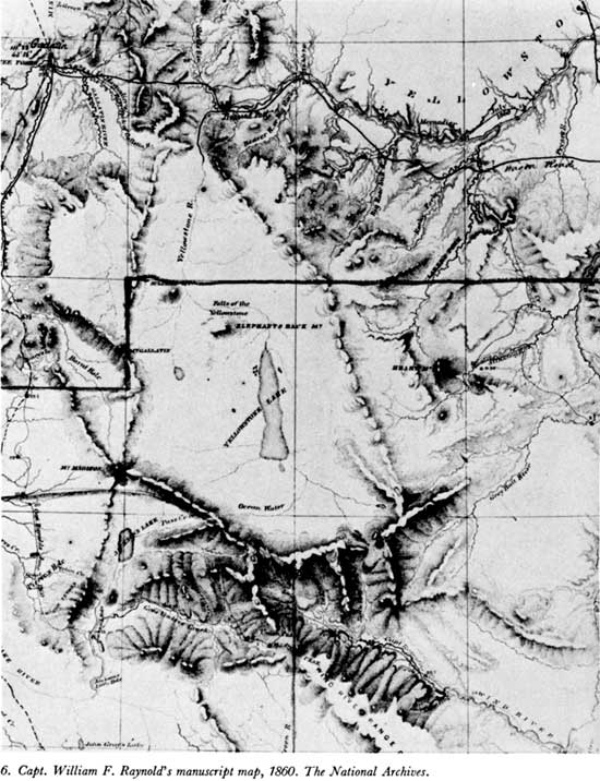
The map which accompanied Captain Raynolds' belated report (publication was delayed by the Civil War), though generally less informative than either the Hood or the Bridger-DeSmet maps, does add something to the body of knowledge concerning the Yellowstone region. [82] Northwest of the outlet of a spindle-shaped "Yellowstone Lake"—but south of "Falls of the Yellowstone"—is "Elephants Back Mt." Below the falls, and in the proper location to represent Mammoth Hot Springs, is "Sulpher Mt.," while a "Mt. Gallatin" makes its appearance in the position of present Mount Holmes. Raynolds' map also confirms the location of the "Burnt Hole" of the trappers, showing it to lie between Henry's Lake and Mount Holmes (see map 6).
Of that valley, which would later be confused with the geyser basins on Firehole River, Raynolds says:
After crossing Lake fork [below Henrys Lake], Mr. Hutton, Dr. Hayden, and two attendants turned to the east and visited the pass [Targhee] over the mountains, leading into the Burnt Hole valley [Madison Basin]. They found the summit distant only about five miles from our route, and report the pass as in all respects equal to that through which the train had gone [Raynolds Pass]. From it they could see a second pass upon the other side of the valley, which Bridger states to lead to the Gallatin. He also says that between that point and the Yellowstone there are no mountains to be crossed." [83]
Top
Last Modified: Tues, Jul 4 2000 07:08:48 am PDT
http://www.cr.nps.gov/history/online_books/haines1/iee1c.htm
![]()