|
Grand Teton
Historic Resource Study |

|
CHAPTER 12:
The Transportation Frontier (continued)
The telephone, which revolutionized communication, made its debut in Jackson Hole in 1905, when Fred Lovejoy established the Jackson Telephone Exchange. He connected the first lines between the Jackson Hotel and Mose Giltner's ranch, three miles west of Jackson. The federal government contributed significantly to expanding telephone service through out the valley. In 1907, the Forest Service built telephone lines all the way from the Hoback to the Buffalo Fork and Yellowstone. By January 1909, the first issue of the Jackson's Hole Courier reported that the valley had its own system operated by the Jackson Valley Telephone Company. "Its lines, supplemented by those of the Forest Service, extend from one end of the valley to the other, and connect with the Bell System at Victor, Idaho," bringing "the scattered localities of the valley. . . near to one another and to the outside world." [55]
After 1909, telephone communications improved and extended steadily. The Reclamation Service strung a telephone cable from Moran to Ashton along the Reclamation Road. In South Park, J. G. Imeson operated a separate telephone system. In 1918, Fred Lovejoy took over the South Park System, absorbing it into the Jackson Valley Telephone Company. This small company owned by local residents, was sold to Mountain States Telephone in 1932. [56]
Early car travel in Jackson Hole after 1900 augured great changes. A party of tourists drove the first automobile into the valley in 1908. Traveling over Togwotee Pass from Fort Washakie, a very rough road, they drove along Jackson Lake to the Snake River Station at Yellowstone National Park. Too late, they learned that the army prohibited automobile travel through the park. Superintendent S. B. M. Young would not let them tow the car through the park with a horse team, but let them haul it to the west entrance on a freight wagon. [57]
In either 1910 or 1911, William Dunn drove a Cadillac via the Ashton Road to Jackson Hole. A trained mechanic, Al Austin accompanied Dunn to "mend tires." According to a captioned photograph in the Jackson's Hole Courier, Dan Hudson, a state game warden, drove the first car, a "White Steamer," into the valley under its own power in 1910. The route is unknown. After 1910, Mrs. John Moulton, a 14-year-old girl at the time, accompanied her uncle over Teton Pass in his EMF. They required a tow from a tandem of horses to make it over the divide. Mrs. Moulton believed her uncle's EMF was the first auto over Teton Pass. An unreliable vehicle, she recalled a common joke that EMF stood for "Every Morning Fix-it." In 1914, Mr. and Mrs. Ed Burton of Pocacatello, Idaho, managed to drive a Hupmobile over the pass without assistance. According to a contemporary account, the Burtons' car was the second to come over Teton Pass, but the first to make it on its own power. In August 1916, attorney Payson W. Spaulding drove over the Hoback Road from Pinedale in the company of another party. Although the journey was rugged, Spaulding found the drive scenic. [58]
Automobiles gained acceptance rapidly among valley residents. Perhaps it was an omen of the new era when a colt turned from its mother and followed Dunn's Cadillac as it chugged through the sleepy town of Jackson. The truth of this story is doubtful, but it suggests that valley residents recognized the changes the gasoline engines would bring. In November 1916, pioneer rancher Mose Giltner purchased a 1917 Buick Four and brought it proudly over the pass. By the end of World War I, trucks were used to haul freight and mail. The 1920s saw a dramatic change as people switched from horse-drawn vehicles to automobiles, although they continued to use sleighs in the winter. Even Jimmy Manges, a homesteader on Taggart Creek, gave in and bought a new car in 1926. The Courier reported that he was "enjoying the sensation of driving his new Dodge Sedan himself lately." [59]
Switching from horses to gasoline engines created demand for cars, and several residents established sales outlets. In 1915, Charles Wort and Dick Winger started the first dealership, bringing in three Ford Model Ts. In the same year, Spicer and Lloyd branched out from their saloon business, announcing their intentions to establish a car dealership for Mitchells, Dodges, and Buicks. Even the village of Kelly boasted an automobile dealership in 1919, where Spicer and Curtis sold Fords. [60]
Gas stations—the most familiar of roadside institutions—became conspicuous in the valley by the mid-1920s. In the early years, car owners stored gasoline in barrels at their residences or businesses. Entrepreneurs, such as A. J. Carter of Driggs, Idaho, operated mobile filling stations, delivering gasoline to individuals. In 1921, Carter brought his tanker over Teton Pass twice a week to fill barrels on order. A year later, Chester Simpson installed a pump in front of his hardware store in Jackson and began selling gas. In May 1924, Mike Yokel opened a gas station in Wilson. [61]
The automobile introduced another phenomena, one that has become too familiar, the car accident. In 1917, a Salt Lake City salesman named Carl Gessel lost control of his Oldsmobile Eight while trying to avoid a mud hole and drove off the Teton Pass Road. The car rolled four times, tumbling 60 feet before lodging against a tree. Astonishingly Gessel was not hurt and even more miraculously he drove the Oldsmobile back to Salt Lake after replacing a wheel. In August of that year, an accident occurred at Menor's Ferry when George Wilson lost control of his car and it plunged into the Snake River. Wilson managed to rescue his wife, but his 13-year-old daughter clung to a wheel of the car as the current swept it downstream. The car washed against a gravel bar, probably saving the teenager's life. Bill Menor rescued the girl with his boat. As motor cars became more common, conflicts with horse-drawn vehicles occurred. For example, in the fall of 1918, an auto spooked Emile Wolff's team, causing the wagon to spill and throwing Wolff's family and Mrs. Hoagland and her son from it. Again, there were no injuries, but the wagon was damaged. [62]
Poor roads contributed to at least one of the preceding accidents, which reinforced the need for dramatic improvement of the nation's roads. By 1925, three highways served Jackson Hole: the Teton Pass Road, the Hoback Road, the Togwotee Pass Road. Major highways were constructed over each of these routes because they provided access to the railroad communities of Victor, Idaho, and Rock Springs and Lander, Wyoming. Both the Ashton-Moran freight road, and the Gros Ventre Road fell into disuse in the 1920s. The state and federal government abandoned the Gros Ventre Road into the upper Green River Basin in favor of the Hoback Road, possibly because the former was more difficult to maintain and keep open. The Gros Ventre River drainage was notorious for the number of landslides that occur in the area. [63]
A lack of funding limited road improvements, but ways were found to raise money. For example, in 1921, the voters of Teton County supported a state road bond by a whopping majority of 336 yeas to 26 nays. Boosters favored almost universally highway construction projects and regarded opposition equivalent to heresy. County, state, and federal agencies assumed responsibility for road maintenance and improvements. In 1925 alone, the Jackson's Hole Courier announced that the Bureau of Public Roads, the Forest Service, and the Wyoming State Highway Department planned to work in Jackson Hole during the coming season. In particular, the Forest Service contributed to road improvements in the valley. [64]
Local surveyor Otho Williams laid out the Teton Pass Road in 1900. It still remained no more than a wagon road with a seemingly endless repetition of switchbacks. In 1918, the Bureau of Public Roads completed a new road over the pass. For the most part, it followed the alignment of the old wagon road. Several years later, in 1925, the Forest Service allocated $12,000 to surface the Teton Pass Road. In 1932, the Bureau of Public Roads initiated a major upgrade of the road. They widened the road from eight to 18 feet, surfaced it, and reduced some grades three to four percent over the same alignment. The road was oiled in 1940. The next major roadwork occurred in the early 1970s, when the Teton Pass route was overhauled to include major realignments of the route to improve safety and reduce the impact of snowslides. [65]
The old Indian and trapper trail over the Hoback was adequate for horses and pack animals, but could not handle wagon traffic. Precise information on just when a wagon trail was built in the Hoback Canyon is unavailable, but the U.S.G.S. Gros Ventre Quadrangle, surveyed in 1907, shows a wagon road crossing the Rim and passing through the upper Hoback drainage at Bondurant to the narrows of the canyon. A photograph dated around 1912 records a road crew on the Hoback taking a break. Thus, by 1907, the Hoback Road accommodated wagon traffic. In 1916, Payson W. Spaulding, accompanied by another party, drove two automobiles from Jackson to Pinedale via the Hoback Road. In 1918, the Forest Service proposed to construct a major road through the Hoback. Construction crews began work after 1918 and completed the project by the summer of 1922. The new road tied Jackson to Rock Springs and the famous Lincoln Highway passing through the communities of Kemmerer and Big Piney. Local dignitaries held official opening ceremonies on July 10, 1922. The production crew filming The Cowboy and the Lady recorded the ceremony for possible use in the movie. The road proved to be a maintenance nightmare; severe weather and rockslides cut off and damaged the road all too frequently. In 1918, the Courier reported that a drenching cloudburst washed out six to seven miles of road. Two years after the completion of the new highway the Bureau of Public Roads had to rework six miles of it. The new highway continued to deteriorate. In 1932, the Courier described the road as a "disgrace" from the V Bar V Ranch to Little Granite Creek. Nonetheless, it emerged as a major artery into Jackson Hole in the 1930s, as automobiles replaced trains as the primary mode of transportation. [66]
Around 1900, the federal government had financed the construction of a military road over Togwotee Pass to link Fort Yellowstone and Fort Washakie. From Togwotee Pass, the road entered the Buffalo Fork valley and possibly joined the Sheridan Trail alignment at Jackson Lake. In 1917, the Courier announced that the road from Lander, Wyoming, to the south entrance of Yellowstone was open to automobiles. The Secretary of the Interior's decision to allow motor vehicles in Yellowstone in 1915 probably generated more traffic through Jackson Hole. About 1919, construction began to provide a major highway. The road opened in 1921 and was graveled in 1922. In that year, the Denver Post reported the completion of the highway between Lander and Yellowstone. A private company initiated bus service from Lander in that year, running until snowfall forced the closure of the road. [67]
From an engineering viewpoint, constructing a highway through the Snake River Canyon was the most significant accomplishment. The idea of a road through the canyon had been proposed prior to 1920, but never had been taken seriously. In 1923, the Forest Service sought a federal appropriation to construct a 19-mile road through the canyon. The bureau justified the road for two reasons; they hoped to eliminate the Teton Pass route and claimed the new road would shorten the traveling distance from Jackson Hole to Salt Lake City. Local communities, such as Jackson and those in Star Valley, supported the proposal. However, the plan remained a pipe dream until the Great Depression, when the federal government pumped millions of dollars into such projects as a part of an economic recovery effort. In the summer of 1931, an 18-man crew began surveying a road through the canyon, moving the highway one step closer to reality. Nothing happened until 1933, when the State of Wyoming applied for and received $600,000 to build the road. Construction began in 1934. The Civilian Conservation Corps provided workers for labor-intensive activities such as rockwork. By 1939, less than 4,000 feet of preliminary work remained, and only one-and-a-half miles were left to grade and widen. The Snake River Canyon road opened to traffic in 1939, completing "one of the largest" such projects in the West. [68] Other roads received no funding. One was a proposed access road from Ashton to the Yellowstone south entrance. The House Appropriations Committee eliminated $100,000 for this project in 1932. It is unclear whether this road was to follow the old Reclamation Road or another alignment. [69]
|
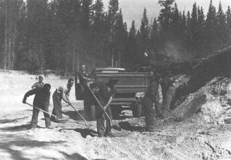
| Civilian Conservation Corps crews built or improved many of the roads in and around the park during the 1930s. Grand Teton National Park |
The 1920s witnessed tremendous improvements in the valley's road network. Depending on the responsibility, funding for maintenance and administration came from county, state, and federal governments. In 1924, the Bureau of Public Roads completed a project on the Wilson-Jackson Road. To overcome budgetary limits, other methods were employed. For example, the state sponsored "Good Roads Day" which encouraged citizens to come out for one day and patch damaged roads. [70]
The existing roads after World War I were made for horse-drawn vehicles. In some instances, alignments were suited to automobiles. Local officials had to decide whether to commit funds to existing alignments or survey and construct new roads. In 1919 local residents disputed, hotly at times, the route of the Jackson-Kelly Road. Some considered the existing road through Dry Hollow too dangerous for automobile traffic. They eventually settled on routing the main road along the east base of East Gros Ventre Butte. Traditional river crossings were fords or, at best, crude bridges. In this period, permanent bridges were built at most fords. During the summer of 1917, crews constructed a bridge across the deep draw near the mouth of Ditch Creek as part of a new road from Menor's Ferry to the Grovont Post Office, located east of Blacktail Butte. Farther up Ditch Creek, materials had been delivered for another new bridge. To the north, Spread Creek's multiple channels dispersed over a cobbled alluvial fan, posing significant problems for travelers. In 1924, the Courier reported that people in the north were determined to have a permanent bridge across the creek, their patience worn out with existing conditions. [71]
In most cases, roads continued to follow the old wagon tracks. The road from Wilson to Menors Ferry followed for the most part the old alignment when it was improved in 1927. The most significant development in the 1920s was the construction of a state highway from Jackson to Menor's Ferry. The road continued north along the base of the Teton Range past Jenny Lake to Moran, where it linked up with the Yellowstone-Lander highway. In addition to the steel truss bridge erected at Menor's Ferry the Bureau of Public Roads built a steel truss bridge across the Gros Ventre River near today's highway. The basic highway and county road system was established by the late 1920s, and remained intact until the 1950s. [72]
A proposal surfaced after World War II to construct a new highway from the south boundary of the Jackson Hole National Monument to the Buffalo Fork River. In 1948, National Park Service Director Newton P. Drury, responding to a letter from Charles Moore, the president of the Dude Ranchers' Association, clarified the Park Service position. The service was not delaying the proposed project, but rather had some concerns about the alignment of the road and impacts on wildlife habitat. Drury stated that the service favored a highway diverting from the existing road at Blacktail Butte and running north across Antelope Flats to Deadman's Bar, then across Spread Creek and the Buffalo Fork to join the Yellowstone-Dubois-Lander highway. The Public Roads Administration constructed the current highway between 1955 through 1957, just as Drury described in his 1948 letter. [73]
Today the main highway is kept open year-round, except when severe storms force closure. Prior to World War II, the state and county governments made no attempt to keep roads plowed because of high costs, primitive snowplows, and the lack of public pressure to maintain plowed roads. With the first heavy snows, Jackson Hole residents stored their Model T's, Hupmobiles, and White trucks, placing them on blocks and draining the engines and cooling systems. Oversnow vehicles, sleds, sleighs, and cutters, drawn by the reliable horse, became the principal form of transportation in the winter. Foot travelers strapped on Nordic skis or snowshoes.
In the 1930s, as the technology became available to remove snow, the public came to expect plowed roads. The variability of winter weather made road conditions difficult to predict. Anticipating the costs of snow removal was difficult as mild winters left tidy surpluses, while severe winters depleted budgets. In December 1929, the park superintendent reported that despite three snowstorms in November, the valley's roads and Teton Pass remained open to automobiles, unusual for that time of year. The winter of 1930-1931 was one of the mildest on record. Only a year later, one of the worst blizzards in several years pummeled the region. Conditions were so bad that heavy snows stranded a snowplow and closed the Hoback Road. No less than 11 feet of snow choked Teton Pass. Harry Scott and Amasa James worked to cut a snow road over the pass. Likewise, in 1936, the monthly Superintendent's Report described terrible weather conditions. Valley residents worked together, committing time and horse teams to keep the roads packed and open. The Hoback Road had been closed most of the month of February while 50 head of horses were used to clear 65 miles of road to Moran. The storm delayed regular mail deliveries for two weeks. [74]
To combat the isolation enforced by winter, state and local governments began investing in improved snow removal equipment. By 1932, rotary plows were being used to clear snow from highways. On June 16 of that year, the Courier reported that rotary plows had opened Togwotee Pass and were pushing on to the south entrance of Yellowstone, which remained blocked by snow. In the winter of 1930-1931, the Hoback Road remained open for the first time in its history attributable for the most part to a mild winter. The next year the Wyoming State Highway Department announced its intention to keep the highway open as much as possible. [75]
They did not succeed. In March 1933, the Courier reported that the Hoback Road would be cleared of snow and open in April after a winter closure. Pressure built to keep the Hoback highway open as this route assumed more importance as a supply link, and the Postal Service began routing Teton County's mail from Rock Springs. The Jackson Lions Club contacted the governor in March 1934, urging him to order the opening of the road from the wye near Daniel, Wyoming, as supplies were getting a little short and some residents were "caught out," while other wanted to "get out." Public pressure had no influence on the weather, however. In January 1936, snow-laden mountainsides shed their loads, causing the heaviest slides in years. The Hoback was completely blocked; 50 volunteers, Forest Service employees, and Game and Fish employees used shovels to try to open the road. [76]
State highway crews kept the Teton Pass Road cleared for the first time in 1937, giving up in January 1938. The following September, the highway department revealed plans to keep the pass open to automobile traffic. To accomplish this, the department allocated a five-ton truck with a push plow. In early December, they received a new 15-ton rotary plow, a huge machine being 25 feet long and 11 feet wide. A 175-horsepower engine propelled the rotor blades. In spite of the new equipment, the highway department gave up on the Teton Pass Road after New Years Day 1940, in the face of severe blizzards. Two hundred angry citizens commandeered two plows from the state highway garages and opened the road. In addition, they protested the local supervisor's decision to the governor. Responding to the pressure from Teton County residents, Governor Nels Smith ordered the department to keep the Teton Pass Road open, ending further civil disobedience. The road was generally kept open until World War II, when gasoline and rubber shortages forced the highway department to reduce plowing, which resulted in closures. Some remember the pass as being generally kept open through the war. By that time, the Snake River Canyon highway provided alternate access to Idaho. Since the war, the pass has been kept open, except for sporadic closures caused by blizzards or snowslides. [77]
In the valley the roads north of Jackson were not plowed through the 1930s. Plows kept the road to Moran open until January to accommodate the influx of hunters. The highway and county road to Moran were unplowed from January to March or April each year, depending on the snow cover. On January 12, 1939, irate residents of Moran petitioned to have the road plowed through the winter and sought help from the Jackson Hole Commercial Club. By the 1940s, major roads in the valley were kept open, and access in and out of the valley was possible via the Togwotee Pass highway the Hoback Road, and the Snake River Canyon road. [78]
Auto and train travel, although most common, were not the only modes of transportation. When H. H. Barker and I. G. Winton landed their biplane at the Jackson rodeo grounds during the Frontier Days celebration on August 19, 1920, they raised quite a stir among the crowd. Excited bystanders gathered about the airplane. Leaving Blackfoot, Idaho, at 4:30 PM., Barker piloted the craft over the Teton Range and landed in Jackson at 5:45 PM., making the 120-mile trip in one hour and 15 minutes. Barker and Winton offered rides to fairgoers and had 59 riders. It was probably the first airplane some of the passengers had ever seen. The appearance of Barker's biplane above the horizon suggested new possibilities for transportation in and out of the valley. [79]
In February 1926, the Courier reported that an Idaho aviator named Tommy Thompson intended to begin air service from Idaho Falls to Jackson Hole, charging $40 for round-trip fare. The flight would cut travel time considerably when one considered that it took three days to reach the valley by train. There is no evidence that Thompson established the service. In 1930, the superintendent of Grand Teton National Park reported that an airplane had been seen traveling north on two occasions in March. An investigation revealed that a pilot from Idaho Falls had spent some time in Jackson Hole, making plans to establish mail and passenger service from Idaho Falls to Moran. He had invested heavily in the projected service, buying a new Wright plane for the route. But, again, no information exists to show the service became a reality. [80]
Local interest in developing an airport and commercial service evolved in the 1930s. Dr. Charles W. Huff, the valley's physician, led the effort. At the end of 1933, the Wyoming Tribune Leader reported that air service might be established from Rock Springs to Jackson with stops in communities in the Green River valley. Promoters of the air service saw a rosy future for winter sports in the valley and believed air service would facilitate development. Dr. Huff sought Civil Works Administration funding to construct an airfield. In 1934, three potential airport sites emerged: the old Frank McBride place north of the Gros Ventre bridge; a tract east of Flat Creek and four miles north of Jackson; and former JP Ranch lands located east of the highway and south of the Gros Ventre River. In early January Huff toured the valley with aviator A. A. Bennett, seeking suitable sites. In March, Dr. Huff telephoned Harold Fabian, vice president of the Snake River Land Company, to request a five-year lease to the JP site from the company. Rockefeller agent Kenneth Chorley expressed serious reservations about the compatibility of an airport with the Snake River Land Company's plan. Huff dropped the request, when a company called Air Transport Lines built a 200 by 1,000-foot airstrip across from the rodeo grounds in Jackson. This field served the community as a "small, unimproved" airport through the 1930s. [81]
In 1940, the Jackson town government, individuals, and citizen groups began lobbying for a new airport and commercial service. In early March, the mayor of Jackson, Harry Clissold, led a delegation to Salt Lake City to meet with Harold Fabian, who also served on the board of directors of Western Air Express. Clissold and other supporters proposed locating the airport southwest of Blacktail Butte and east of the Snake River, where the airport is situated today. Located on federal lands and on Snake River Land Company property, the town of Jackson needed to secure leases from both the company and the Interior Department. In addition, Western Air Express had to seek review and approval of a route from Salt Lake City to Jackson from the Civil Aeronautics Authority. The paperwork took time. Moreover, there were other concerns that delayed the construction of the airport; some questioned the need for a commercial airport, and once a consensus formed supporting it, a suitable location became the subject of debate.
Fabian supported the plan probably for two reasons. First, he believed that the market could support commercial air service and, in turn, the service was needed. Second, yet just as important, Fabian perceived the airport as a way to gain acquiescence, if not support, among Jackson Hole residents for the proposed park extension. John D. Rockefeller Jr., Laurence Rockefeller, Vanderbilt Webb, and Kenneth Chorley agreed "that the Snake River Land Company should not take the position of opposing in any way the establishment of a proper airport." However, they expressed concern about the scenic intrusion of an airport located between the highway and the Teton Range. There was not a consensus of opinion. Horace Albright questioned the need for an airport, writing to Chorley that "they are definitely an intrusion into wilderness areas." Chorley responded that even though the need for an airport and personal choice to fly was a matter of opinion, "I am inclined to think that Jackson Hole would be better off without an airport." In a letter to Vanderbilt Webb in May 1941, Fabian wrote "I understood the Park Service does not favor airline service into Jackson Hole; that both the traffic and operating officials of Western Air Lines prefer not to land there [and] that the Snake River Land Company does not favor airline service there nor the construction of an airport between the highway and the mountains." [82]
Nevertheless, the Interior Department and company agreed to give the town a lease. The site remained the only issue. Webb, in his March 27 letter to Fabian, suggested locating the airport in the Kelly-Mormon Row area. All interested parties supported a site on Antelope Flats, but the chief operations officer of Western rejected this location, because of unpredictable winds diverted by Blacktail Butte. They did find a location north of Timbered Island, about one mile east of Jenny Lake. The National Park Service objected to this site. Acting Director Arthur Demaray stated that it "would be inimical to the best interests of the park and local community." To add to the confusion, Moran residents supported an airport south of Signal Mountain, and even scraped out a small airstrip in the sagebrush flats. Then, Mayor Clissold, irate over the Timbered Island proposal, announced his intention to apply for a lease at the original location southwest of Blacktail Butte. [83]
Sometime between 1941 and 1943, local residents cleared an airstrip at the present location, commandeering county equipment according to local tradition. The town of Jackson secured a lease from the Interior Department on June 16, 1942, and from the Jackson Hole Preserve, formerly the Snake River Land Company, in November 1943. Western Air Express initiated commercial service in 1946. Today the airport operates under a 50-year lease within Grand Teton National Park. [84]
Local tradition has it that a small airstrip existed at the current airport in the 1930s. Documents in the Harold Fabian Papers and Kenneth Chorley Papers in the Rockefeller Archive Center do not mention an airfield in this area in 1940. Had there been one, it seems reasonable that it would have been mentioned in correspondence. Further, the Jackson's Hole Couriers during the 1930s refer to the airfield being near the fairgrounds in Jackson. However, no mention of a landing field southwest of Blacktail Butte was found. Finally a photograph taken from Blacktail Butte of the airport area, dated August 13, 1937, shows that an airstrip did not exist prior to that date at that location. Today thousands of travelers use the Jackson Hole Airport.
The first permanent occupants of Jackson Hole settled in a remote mountain valley. Mail was irregular and getting supplies into the valley proved difficult and time consuming. Trips to Jackson were made once or twice a year, while excursions outside Jackson Hole were unheard of for most settlers. Railroads facilitated settlement, providing access to supplies and a way for homesteaders to get their only export, cattle, to market. Roads improved gradually until 1918, when the automobile revolutionized life in the United States, not to mention Jackson Hole. Government organizations improved the road system dramatically in the 1920s. Motor vehicles replaced the horse. Rotary plows and blade plows began keeping most roads open by the 1940s. In 1920, the first airplane landed in the valley; 22 years later an airport was established.
Today a modern highway system is in place with four major routes kept open year-round. Virtually all goods such as food, clothing, and gasoline are hauled by truck over the highways into Jackson Hole. Most of the 2,500,000 visitors who travel to Jackson Hole each year arrive in air-conditioned vehicles, keeping time to music played on tape decks through stereo speakers. Our society cannot conceive the difficulties travel posed for people scarcely a century ago.
| <<< Previous | <<< Contents >>> | Next >>> |
grte/hrs/hrs12b.htm
Last Updated: 24-Jul-2004