|
GLACIER BAY
Land Reborn: A History of Administration and Visitor Use in Glacier Bay National Park and Preserve |

|
| PART THREE: WILDERNESS PRESERVATION, 1966-1992 |
Chapter XIII:
Creating A Wilderness Park
Nearly thirty years have passed since NPS administrators first began using the term "wilderness park" to describe Glacier Bay National Monument. In that time, the idea of a wilderness park has evolved, both in a generic sense and as it has applied to Glacier Bay. The wilderness park idea took root when growing public concern about massive environmental change was etched in national park policy by the Leopold Report of 1963. It acquired more specific form when public support for wilderness preservation crystallized in the Wilderness Act of 1964. NPS officials applied the concept to Glacier Bay National Monument in the mid-1960s as the growth of a regional tourist industry pointed to increasing visitor use of the monument. In the 1970s, this Glacier Bay wilderness park idea withstood various challenges--from proposals to build roads into the monument's interior, to legislative amendments that would have lopped off portions of the monument for mining development, to attempts to open Glacier Bay to uncontrolled increases in vessel traffic. That none of these things eventuated owed less to strongly reasoned arguments about what a wilderness park was than it did to steadfast ideas of what a wilderness park was not. By the 1980s, park administrators were reaching more and more for positive criteria with which to define a wilderness park.
Their answers tended to cluster around two sets of criteria, one humanistic or "anthropocentric," the other scientific or "biocentric." To define a wilderness park in anthropocentric terms was to analyze visitor perceptions of a "quality wilderness experience." The goal was to translate intangible wilderness values like solitude and wildness into objective terms that could assist park administrators in preserving wilderness. How much did a cruise ship puffing past the entrance of a fjord detract from a backcountry user's wilderness experience? How did this compare to the sight of an overused campsite, or the need to share a campsite with another party? Did encounters with large backcountry parties detract from a backcountry user's wilderness experience more than encounters with small parties? And more broadly, did the wilderness experience fulfill or fall short of a visitor's expectations? Similar questions were asked of the cruise ship and tour boat passenger. Park administrators looked to sociologists to objectify visitors' wilderness experiences. To this end, sociologists conducted four visitor questionnaire surveys in Glacier Bay National Park and Preserve between 1978 and 1989.
To define a wilderness park in biocentric terms, meanwhile, was to analyze human impacts upon a relatively pristine environment. Like ecosystem management in the 1960s and 1970s, the biocentric approach to wilderness management relied on biological research. And like ecosystem management, the purpose of the biocentric approach to wilderness management was to create a more authentic wilderness. But the biocentric approach, starting with the cultural and moral construct of "wilderness" rather than the ideologically neutral concept of an ecosystem, tended to find fewer mitigating circumstances for human impacts.
Although the whale management regulations adopted in the 1980s limited the number of most types of vessels permitted in the park during June, July, and August, park administrators recognized that this gave them a rather flimsy handle on total annual visitation. The whale regulations allowed for incremental increases and set no final limit, while the park's general management plan placed no ceiling on annual visitation either. In order to preserve the park's wilderness character for future generations, most park officials agreed, ultimately the NPS would have to cap visitor use at some undetermined level. The search for those future limits--the park's recreational carrying capacity--underlay much of the Park Service's efforts in management planning for vessel, backcountry, and Alsek River use in the 1980s and early 1990s.

|
| Alsek River and Dry Bay. (click on image for an enlargement in a new window) |
Alsek River Float Trips
In August 1971, a daredevil river runner hired a bush pilot to fly him and his kayak up the wild Alsek River. Flying low up the canyon so that he could preview the trip, the kayaker noted sand bars in the river roughly every five miles where he could take refuge from bears and await rescue if the river proved too much for him. He told the pilot if he were found dead to bury his remains in the canyon and take positive proof back to his wife. With that request, Walt Blackadar set out on a six-day trip down some of the "worst foamy rapids a kayaker can imagine." [1]
The kayaker's story in Sports Illustrated, together with one other river runner's account in Alaska Magazine, prompted the Alaska Conservation Society in 1973 to urge inclusion of the Alsek River corridor in the D-2 withdrawals then under consideration. [2] Wilderness river trips were fast gaining popularity in the United States. Commercial outfitters built a multi-million dollar industry taking tourists on guided raft trips in this decade. Recreational use of the Colorado River increased exponentially during the late 1960s and early 1970s, forcing NPS officials in Grand Canyon National Park to freeze the number of river rafters at 1972 levels while a comprehensive research program was undertaken. [3] As for the Alsek, seven commercial river guides were advertising float trips by 1977, one year before President Carter proclaimed the Alsek addition to the monument. Looking at the growth of Colorado River use as a precedent, experts expected a rapid expansion of privately organized trips on the Alsek to follow. [4]
To float the Alsek, most river runners put in on the tributary Tatshenshini River at Dalton Post, Yukon Territory. The "Tat" is a spectacular white water river in its own right. It normally takes eight to twelve days to run the 135 miles to the take-out point at Dry Bay, with all but the last three days spent in the Yukon and British Columbia. In its lower section through the park the Alsek widens out, enters and exits iceberg-studded Alsek Lake, and meanders for another twenty miles across a low-lying coastal plain, with the preserve on the left hand and the Tongass National Forest on the right. The usual take out point is by a dirt landing strip near the entrance to Dry Bay.
ANILCA provided that a purpose of the Alsek addition was "to protect a segment of the Alsek River, fish and wildlife habitats and migration routes." The legislative history of ANILCA provided two additional directives:
The National Park Service must take such steps as are necessary to insure that overuse of the river does not occur. A quality wilderness river experience should be protected.
The Secretary is encouraged to seek cooperative agreements with Canada which serve to protect the entire watershed of the Alsek River, and provide for cooperative visitor use of the river and its environs. [5]
With these strong directives, the Park Service made the Alsek River its first priority in establishing wilderness use limits for Glacier Bay National Park and Preserve.
The effort began even before Congress enacted ANILCA, when an NPS official announced at a Western River Guides conference in early 1979 that the Park Service would begin issuing permits for the Alsek as a first step toward limiting use. Permits would only be issued to companies who had guided trips prior to December 1978. Pending the development of an interim management plan for the river, the Park Service issued letters of agreement instead of park concession permits for 1979 and 1980. [6]
NPS officials initiated two meetings with the Canadian management agencies that held jurisdiction over the Tatshenshini River (one for the segment in British Columbia, another for the segment in the Yukon). These meetings produced agreement in principle that the Tatshenshini-Alsek River should be treated as a system, but at this time the Canadians would do little in the way of regulating recreational use. They allowed the Park Service to take the lead in developing a management plan. [7]
The interim river management plan, which the Park Service drafted and pushed through the public review process between 1979 and 1982, proposed a fifty-fifty split between American- and Canadian-permitted trips, and a further fifty-fifty split between commercial and private parties. This four-way allotment of permits was farsighted, since no Canadian guide services and few private parties of either nationality were yet involved. The plan set the total number of trips for United States-based river guides at seventeen, to be divided among seven companies. (Twice as many companies applied for permits in 1979, but preference was given to the companies that had run float trips on the Tatshenshini-Alsek between 1976 and 1978. Without the plan, there can be no doubt that the amount of commercial trips would have quickly exceeded seventeen.) The commercial trips were to be spread over seven two-week periods, with no more than one take-out scheduled per day. The plan also set a limit of twenty-five people per party and gave detailed instructions for minimizing impacts at campsites. [8]
The interim plan called for a research plan "directed towards defining the ecological and sociological carrying capacities" of the Alsek River. Ecological (biocentric) research mainly consisted of yearly documentation of defoliation, soil compaction, and other human impacts around commonly used campsites, using the so-called code-a-site system. Of particular concern was the effect large groups might have on the delicate Dryas matt that was common in the area. As for sociological (anthropocentric) research, sociologist Darryll R. Johnson of the Cooperative Park Studies Unit at the University of Washington initiated a river user survey in 1982 to acquire baseline data for Alsek River management. Matthew S. Carroll conducted the chief survey effort in 1984, floating the river in June and administering questionnaires to 336 river users at the take-out point between June 25 and August 30. The study by Johnson and Carroll provided data on the characteristics of parties and river users as a whole, from such objective facts as age, sex, place of origin, and income level, to their perceptions of wilderness, crowding, regulation, and development. [9] The data assisted Park Service officials in refining the Alsek River management plan in 1988. More importantly, perhaps, Park Service administrators expected to compare the "baseline" data to another data set at some later time to evaluate potential changes in the quality of the wilderness experience. For the time being, officials were fairly confident that the 68-trip limit was within the natural and recreational carrying capacity of the wilderness.
Superintendent Marvin Jensen noted the importance of working with Canadian officials to manage the river system, but said the Canadians were years behind in developing wilderness management strategies. At least until British Columbia's change in government in the 1992 election, the province showed little interest in protecting the Tatshenshini. This was nowhere more evident than in Jensen's early meetings with provincial officials. "When we meet and talk about our agenda for protecting wilderness values," Jensen said, "we are met with blank stares--'What the hell is wilderness?'" [10] That American and Canadian officials speak almost a different language of wilderness management underscores just how culturally determined Americans' wilderness values are.
Backcountry Use and Bear Management
Backcountry users are more influential in Glacier Bay National Park and Preserve than their numbers might suggest. The number of backcountry users rose in the 1970s and 1980s from a few hundred to approximately a thousand per year--a mere one-half to one percent of the total visitation. But backcountry users tend to stay in the park much longer than other park visitors, so that when visitation is expressed as visitor-days their percentage of the total increases substantially. More importantly, their interests are represented by national organizations like the Sierra Club and the Wilderness Society, so that in negotiations over such public policy issues as wilderness designation, this national park constituency is almost as well represented as the tourist industry or commercial fishermen.
Backcountry users also present greater challenges for management than their numbers first suggest. Not only do backcountry users go into the wilderness with greater expectations of finding solitude, observing wildlife, and otherwise enjoying an untrammeled environment, but they themselves have a greater per-capita impact on wilderness values, in both biocentric and anthropocentric terms, than do mass tourists in Glacier Bay, most of whom never set foot on land. The Park Service's best shot at minimizing backcountry users' impacts is through orientations--educating them to the special environmental concerns of park management before they go into the backcountry. But the NPS has less contact with this group than with any other type of park visitor.
Because of the immense size and geographical configuration of the park, the Park Service has developed three or four different approaches for managing the backcountry. Most backcountry use--and most of the Park Service's effort--has been focused on Glacier Bay itself. The NPS tries to contact as many of these backcountry users as possible, either at park headquarters or on the tour boats that drop them in the backcountry. Backcountry use along the Alsek River corridor, by contrast, is so remote from Bartlett Cove that the NPS has relied chiefly on the river management plan and the permit system to reach these park visitors. Backcountry use in the preserve, meanwhile, consists mainly of sport hunting. And finally, the minimal amount of backcountry use on the outer coast is virtually unmanaged.
The predominant backcountry use around Glacier Bay changed in the 1970s from backpacking to sea kayaking. The first sea kayakers in Glacier Bay paddled all the way from Juneau, creating a small sensation among the staff when they appeared at the dock in Bartlett Cove. Soon there were sea kayaking guides and outfitters, similar to the river guides on the Alsek-Tatshenshini. A variant of this outfitter service was to provide all the kayaks, tents, and camping gear, together with transportation by float plane to one of the inlets near the head of the bay, from which the party set out on a self-guided tour of the backcountry. [12] Still another option appeared when residents in Gustavus set up a kayak rental concession.
Sea kayaking has concentrated backcountry use along the shore of Glacier Bay. This is an area rich in plant and animal life where bears, moose, shorebirds, and even mountain goats commonly come to forage. It is also an area of expansive vistas. Consequently sea kayaking has tended to enhance the backcountry user's wilderness experience while also increasing his or her potential for disrupting wildlife and spoiling the solitude of other backcountry users.
Solitude has been a particularly challenging wilderness value for the Park Service to protect in Glacier Bay. The desolate features of the park tend to heighten the visitor's expectation of solitude. One kayaker recalled how his party "wasn't prepared for the starkness, the isolation....The natural stimuli are so subtle it takes a while to notice anything but the emptiness." [13] Another kayaker described her keen disappointment after a first night of solitude in Muir Inlet when she returned from a day trip to find "eight tents sprouted just down the beach" from her campsite. [14] For Dave Bohn, author of Glacier Bay: The Land and the Silence, solitude was the area's defining quality. Unfortunately, the very physical features of this environment that create a feeling of solitude--long vistas, open water, barren slopes rising out of the bay--also tend to accentuate the engine noise of boats and planes and the sight of other backcountry users with their brightly colored kayaks, tents, and rain parkas standing out against the stark landscape.
The imperative of protecting this wilderness value is one of the strongest arguments for closing wilderness waters to all motorized vessels. The NPS has directed the cruise ship and tour boat operators to avoid use of certain inlets in order to protect the inlets' wilderness character for backcountry users. Among these areas, the Park Service has tried to spread out backcountry use somewhat by offering a choice of drop-off sites. But it has had to balance this approach with other needs, such as habitat restoration around heavily used campsites and area closures for wildlife protection.
To protect this wilderness value the Park Service turned to sociologists, visitor questionnaires, and the concept of recreational or social carrying capacity, just as it had for the Alsek River Management Plan. Sociologist Darryll Johnson conducted two backcountry user surveys in 1978 and 1984. [15] One important result was the Park Service's decision to limit group size to twelve members. The surveys indicated that backcountry users felt significantly more crowded by encountering large parties than they did by encountering small parties. Large parties provided a less satisfactory wilderness experience for the members themselves, too. Large parties also tended to make more noise and cause more damage at their campsites. For these reasons the NPS has resisted requests by the main Glacier Bay outfitter, Alaska Discovery, Inc., to raise the limit from twelve to twenty-five to conform with what Alsek River guides are allowed. [16]
Next to protecting the backcountry user's ability to find solitude in Glacier Bay, the most difficult challenge of backcountry management has been with bears. Bears are a particularly sensitive wilderness resource because they are prone to lose their wildness when they are exposed to increasing numbers of humans. Unless precautionary measures are taken, they lose their fear of humans and respond to them as sources of food. Superintendent Chapman had just this eventuality in mind when he wrote about the Alsek River: "We are especially concerned about maintaining the wild character of the associated animal populations. Once bear problems start, the whole character of the experience will be degraded." [17]
Until recently, bear management in Glacier Bay National Park and Preserve was less a backcountry problem than a problem with so-called "garbage bears" around Bartlett Cove. In 1977, there were an estimated twenty-five black bears living in the Bartlett Cove-Gustavus area which had become habituated to feeding on garbage and garden vegetables. That winter the Park Service closed the open-pit garbage dump, enclosed a new one with an electrified chain link fence, bear-proofed all the garbage cans around the residences and lodge, and built a food cache for campground campers. These measures succeeded in sharply reducing the number of bear incidents around Bartlett Cove. [18]
The park's bear problem was not confined to garbage bears, however. In 1981, a black bear killed and ate a kayaker at Sandy Cove--many miles from the Bartlett Cove-Gustavus area. The bear was killed and its stomach contents examined to verify that it had eaten the human. The Park Service closed the Sandy Cove area to backcountry use for the remainder of the season. Several other bear incidents were reported, some involving property damage. [19]
Over the next three years, park researchers studied black bear movements and population densities in the Sandy Cove and Beartrack Cove areas, learning that black bears gathered along the shoreline in spring and early summer, where they grazed on sedges and barnacles and other food in the intertidal zone. The Park Service closed certain beaches to camping in May and June, with fewer bear incidents resulting. [20]
In 1988, even as the bear problem at Sandy Cove was brought under control by closing it again, the number of bear incidents in the rest of the park came to nineteen. Six involved black bears around Bartlett Cove, and the other thirteen were in the upper bay. After three incidents were reported in Tarr Inlet, the area was closed from June 24 to July 25. [21] That summer the Park Service initiated a study of brown bear habitat, movements, and population densities in the West Arm similar to the black bear study for Sandy Cove. [22]
In recent years the superintendent has tried to stem the growing number of bear incidents by supplying more information to park visitors and introducing bear-proof food canisters for use on an experimental loan basis. (The cylindrical containers with locking lids are used for food storage in camps where there are no trees for hanging food out of a bear's reach.) Superintendent Marvin Jensen's approach to bear management is biocentric: to change bear behavior by changing human behavior first or, in his words, to make visitors "more directly responsible for prevention of unfavorable human-bear encounters." [23] It is likely that the park will introduce mandatory registration for backcountry use so that rangers have an opportunity to orient visitors to clean camping practices and the use of bear-proof canisters. [24]
Meanwhile, the park has a different kind of bear problem on the outer coast, where park administrators suspect that poachers are after some of the largest specimens of brown bear left in Alaska. Prior to 1992, the Park Service lacked the resources to give this remote area much more than an occasional ranger patrol. This appeared to be changing in 1992, as the park acquired an airplane, a park ranger obtained a pilot's license, and the superintendent planned for the ranger-pilot to divide his time between Glacier Bay and the Dry Bay-Lituya Bay area of the outer coast. Superintendent Jensen hoped that, with the arrest of one or two poachers, the Park Service could awaken people's interest in the problem and get more support. [25]
Backcountry use in Glacier Bay National Preserve consists mainly of sport hunting. When the preserve was created in 1980, NPS officials had even less idea how to manage this activity than they did the Dry Bay commercial fishery. As with the fishery (see chapter fourteen), the Park Service's management options were closely circumscribed by ANILCA, which ensured commercial operators continued access and gave the state of Alaska control of fish and game management. The NPS had little more to do than manage public access to an existing cabin on the East River, and this task it soon turned back to the Forest Service. [26]
Historically, sport hunters were attracted to this area--and the rest of the long coastal plain that stretches north to Yakutat Bay, known as the Yakutat Forelands--primarily because it provides habitat for the largest moose population in southeast Alaska. One study estimated that at least 6,500 sportsmen and subsistence hunters harvested more than 3,200 moose between 1959 and 1975, when the Alaska Department of Fish and Game closed the area to moose hunting because of low moose counts. The Yakutat Forelands were also "world renowned" because they contained the largest concentration of glacier bear found anywhere. [27] A 1973 study suggested that recreational use of the Dry Bay area would increase gradually, with moose hunting continuing to draw the most people, followed by bear and waterfowl hunting and sport fishing. [28]
The Park Service issued special use permits to two commercial hunting guides in the early 1980s. One, A. Israelson, was well-established in the area, having specialized in moose and bear hunting along the Alsek since the early 1970s. [29] The second, J. Latham, had received a permit from the Alaska State Game Board in April 1980, when the state was refusing to recognize NPS jurisdiction over the 1978 monument addition. Part of the area described in Latham's permit was subsequently designated as preserve by ANILCA.
A statement for management in 1982 indicated that the trend of sport hunting use in the preserve would likely remain stable for the near future, while some form of cooperative management with the state would be needed to maintain quality of habitat, fish and wildlife populations, and wilderness experiences. [30] The park's General Management Plan did not elaborate on this plan except to suggest consideration of having hunting guides operate as NPS concessioners. With no further recreational use planning having been done for this area, the NPS has been somewhat compromised when challenged by organizations such as the Alaska Land Use Council or the City of Yakutat to enter into cooperative planning for the whole Yakutat Forelands. So far, NPS officials have rejected these overtures, apparently confident that without additional hunting guide services, backcountry use in the preserve will stay within acceptable limits.
Glacier Bay Science a Century After Muir
A landmark event in the history of Glacier Bay science took place in September 1983, when more than 130 scientists, social scientists, and resource managers gathered at Bartlett Cove for the First Glacier Bay Science Symposium. Suggested by glaciologist William O. Field, co-sponsored by the park and Friends of Glacier Bay, and dedicated to the memory of the park's founding father William S. Cooper (1884-1978), the symposium was both a celebration of one hundred years of science at Glacier Bay and a reckoning of Glacier Bay science in the future.
Four separate panels discussed a wide range of topics in geology and climatology, terrestrial ecosystems, marine and aquatic ecosystems, and resource management. The symposium put the cumulative effect of scientific studies in Glacier Bay in context and provided a welcome opportunity for interdisciplinary exchanges. The proceedings demonstrated that Glacier Bay was practically unexcelled as a place for the study of primary ecological succession following glacial recession, and in addition, boasted coastal rainforest for comparative studies of secondary ecological succession, pristine freshwater lakes for the study of aquatic ecosystems, and perhaps the most closely studied population of humpback whales anywhere.
The mood of the proceedings was at once ebullient and marked by sober reflection about the proper relationship of science to the park. With so much discussion about protecting the park's wilderness waters and establishing the park's carrying capacity, it was not surprising that Glacier Bay scientists should direct such questions toward themselves as: Was scientific use of the park entirely compatible with the purposes of the park? How much scientific research could the park sustain without losing its wilderness character? What could they, as scientists, social scientists, and resource managers, contribute to this exceedingly complicated problem of carrying capacity? In managing Glacier Bay National Park and Preserve, the NPS had one of the strongest mandates for scientific research of any unit in the national park system. Yet scientists' needs still had to be weighed against the interests of wilderness enthusiasts and other park users.
With research requests increasing, it had become necessary to establish guidelines about proper research methods to avoid undue impacts on the environment. "Impacts must be carefully weighed against the knowledge to be gained," resource specialist Gary Vequist cautioned. Vequist suggested the following criteria:
1. Research should be conducted in a manner that was not highly visible to other park visitors.
2. Research should be coordinated with other ongoing research efforts.
3. Research should address topics for which the park was uniquely suited as a study area.
4. Research would be favored if it was useful for the management of park resources. [31]
While some scientists at the symposium voiced concern that their needs would be inordinately hindered by such proposals as that to close Muir Inlet to motorized access, a consensus emerged that the interests of science in Glacier Bay were aligned with conservative wilderness management. Some scientists went so far as to consider it incumbent upon themselves to contribute something to wilderness preservation through their research.
Immediately after the symposium, park officials and several scientists gave their support to a proposal by the Friends of Glacier Bay for the establishment of a Science Advisory Board. This had been advocated by the Friends for some time. The board's functions were to review research proposals, evaluate research needs, and identify and prioritize areas of research within the park. The Friends of Glacier Bay took the lead in organizing the board, which initially comprised seven members. [32]
Five years after its inception, the Science Board reduced its membership from seven to three, representing the physical, biological, and social sciences, with the park superintendent and the president of Friends of Glacier Bay participating as ex-officio, non-voting members. It urged improved communications between the NPS and the board, and suggested that all research proposals, including those by the NPS, be sent to the board for review and comment. It recommended further that all project investigators submit annual reports to the board to help it coordinate concurrent research projects. [33]
In 1988, the Glacier Bay Science Board and Friends of Glacier Bay organized the Second Glacier Bay Science Symposium. The second symposium was more wide-ranging than the first, and included an overview of ongoing research on the ecology of the brown bears of Admiralty Island and other Admiralty Island studies. The participants agreed that a third symposium, scheduled for 1993, should be broadened further to include regional and ethnocultural topics.
Biosphere Reserve
Ever since the national park idea spread to other nations, and particularly since the formation of the United Nations after World War II, there has been an international dimension to the NPS mission. Secretary of the Interior Stewart Udall, in a keynote address to the First World Conference on National Parks held in Seattle in 1962, likened national parks to "nature islands for the world" in a latter-day Great Flood. The Old Testament's Noah, he reminded his international audience, had constructed an ark large enough to provide protection and survival for all animal species. "Today the threatened flood has a different guise, but its threat is just as real. If we, too, move in time to take protective action, the conservation leaders of this generation may well become the Noahs of the 20th century." [34] In the thirty years since the First World Conference on National Parks, the international scope of the Park Service mission has increasingly emphasized the preservation of global biodiversity. The development of economic incentives mainly in the form of the tourist industry is one major component of this international effort, particularly among developing nations. The coordination of scientific research in order to maximize limited resources is another. It is this latter effort that has given Glacier Bay National Park and Preserve a measure of international significance in the past decade.
In 1986, the United Nations Educational, Scientific and Cultural Organization (UNESCO) established the Glacier Bay-Admiralty Island Biosphere Reserve as part of its International Man and the Biosphere (MAB) program. Founded in 1970, MAB's overall objectives are first, to develop the basis within the natural and social sciences for the rational use and conservation of the biosphere; and second, to improve the relationships between man and the biosphere. MAB emphasizes the need for interdisciplinary studies and coordination of diverse national and international research, conservation, and training programs. One of MAB's fourteen projects, Project 8, concerns the International Network of Biosphere Reserves.
Project 8 developed in response to international concern over the accelerating rate of extinctions of plant and animal species which was occurring principally through the loss of whole ecosystems. Project 8 has three main objectives:
1. Establish an international network of representative protected ecosystems for the conservation of biological diversity (gene "pools").
2. Conduct basic ecosystem research to understand their structure and function.
3.Increase public awareness and support for such conservation activities through education.
Thus the biosphere reserve program lays more stress on research than most other conservation programs. In particular, it emphasizes research on an ecosystem level. This calls for a high degree of coordination and continuity between research projects. The program is intended to facilitate research that will make a contribution both to "the theoretical and practical aspects of conservation and natural resources management." [35] The establishment of the Glacier Bay-Admiralty Island Biosphere Reserve has had an energizing effect on Glacier Bay science. The UNESCO designation assists scientists in obtaining research grants, and it has lent further significance to the Glacier Bay Science Board and helped solidify its partnership role in the management of science in the park.
Six years after enactment of ANILCA, the Park Service began to redefine its mission in Alaska in terms of protecting biodiversity as well as wilderness in the fragile far north. Alaska national parklands not only preserved portions of one of the last great wilderness regions of the world; the Alaskan parks also could be a kind of barometer for measuring such things as the effects of global warming and ocean pollution on the earth's biosphere. Once again the scales were tilting toward a biocentric approach to resource management. The idea was not quite new: Robert Weeden had made this plea for Alaskan wilderness in Alaska: Promises to Keep (1978), as had William E. Brown in This Last Treasure: Alaska National Parklands (1982). Only now, however, did the NPS begin to provide funding for the kind of scientific research program that this mission required.
The problem was that staffing increases in the region in the years following enactment of ANILCA, while impressive, had not been adequate to deal with the huge land area that was added to the system, coupled with the complicated resource management problems that had sprung from subsistence, sport hunting, motorized access, and other peculiar features of the Alaska region. Low visitation to Alaska national parks meant relatively small budgets. The Alaska region administered 23 units covering 55 million acres, or 69 percent of the total area in the national park system--with a mere 3 percent of the agency's annual budget in 1986. Whereas Yellowstone had about one scientist per 148,000 acres, and Olympic and Glacier National Parks each had about one scientist per 100,000 acres, the Alaska region had one resource management specialist per 4,000,000 acres and only three research biologists for the entire region. [36]
In 1987, the Alaska region launched a comprehensive science initiative to lay a sound foundation for informed management of Alaska's national parklands "to a degree unparalleled in NPS history." Over the next ten years, the science initiative would bring budget and staffing levels for ecological research in the Alaska region up to par with the other nine regions in the national park system. Given the relatively small visitation to Alaska parks, this would entail a far greater proportion of funds and positions devoted to natural and cultural resource management in Alaska than in any other region. [37]
Relative to the Glacier Bay-Admiralty Island Biosphere Reserve, the NPS science initiative promised to aid materially in Project 8's overarching goal of ecosystem-level research. The program proposal cited the effects of commercial fishing and crabbing on the Glacier Bay marine environment as a primary concern in that park, together with protection of humpback whales, including changes in prey abundance and the effects of boats upon whales. In 1989-90, Glacier Bay National Park received its first complement of new staff scientists under the plan with the hiring of research scientist Jim Taggart and resource management specialist Mark Schroeder. [38]
Speaking at the Second Glacier Bay Science Symposium in 1988, Dr. Robert Stottlemyer of Michigan Technological University said that the most important responsibility that the NPS has incurred by MAB's designation of the Glacier Bay-Admiralty Island Biosphere Reserve is to support Project 8's commitment to long-term, ecological research (LTER) and long-term ecosystem-level monitoring (LTEM). "At present," said Stottlemyer, "the NPS considerably underestimates the magnitude and complexity of issues challenging the integrity of the natural resources within the National Park System. It must quickly engage in a formal long-term ecological monitoring and research program with priority placed on the biosphere reserves." [39] As the NPS takes on this challenge in the new century, the LTER/LTEM program in Glacier Bay National Park and Preserve will be an important indicator of its success.
World Heritage Site
In January 1990, a Canadian mineral development company, Geddes Resources Ltd., presented the Canadian government with a five-volume project proposal to develop a giant, open-pit copper mine on its Windy Craggy claim near the mouth of the Tatshenshini River in British Columbia. The project would require seventy miles of new road construction through pristine, de facto wilderness and critical wildlife habitat, including an important bald eagle range. Large ore trucks would leave the mine every fifteen to twenty minutes, seven days a week, year round. Of particular importance to Glacier Bay National Park and Preserve was Geddes's proposal to dispose of waste rock from the open pit on the Tatshenshini Glacier and to dump tailings into a manmade lake. Both of these actions would potentially leach sulphuric acid into the Tatshenshini River, with potentially lethal effects for plants and fishes. [40]
The Windy Craggy project alternately looked like an inevitability and an impossibility. The original proposal met with an outpouring of public concern and opposition from environmental groups, and was rejected by the Canadian government in July 1990, mainly because of its inadequate provisions for mine drainage. But Geddes already had a large investment in it and revised the plan for mine waste disposal in an addendum submitted at the end of 1990. With supporters describing the Windy Craggy project as a potential multi-billion dollar industry, it seemed likely to go forward.
Then in December 1990, the International Union for Conservation of Nature and Natural Resources (IUCN), prompted by this mining threat, passed a resolution recommending that the governments of the United States and Canada consider nominating Glacier Bay National Park and Preserve and the bordering area in British Columbia for inclusion in the existing St.Elias-Wrangell-Kluane National Park World Heritage Site. The Department of the Interior moved quickly to prepare a world heritage nomination, and NPS director James M. Ridenour urged the Canadian Parks Service to do the same. Ridenour reminded his Canadian counterpart that the United States and Canada had been the first member nations to submit a binational nomination, resulting in the joint recognition of Wrangell-St. Elias National Park and Preserve and Kluane National Park as a world heritage site. [41]
The Department of the Interior submitted the United States nomination of Glacier Bay to the IUCN on September 25, 1991. The nomination noted environmental threats to the area posed by the patented mineral claims on the Brady Icefield, ten native allotment claims inside the park, the existence of commercial fishing in Glacier Bay, and the proposed Windy Craggy mine--"the foremost external threat...[which] could irreversibly alter water quality in the Tatshenshini/Alsek river system, disrupt riparian ecosystems, and impact fisheries, migratory bird populations, and recreational values in the United States and Canada." This language was subsequently softened in a substitute paragraph sent to the IUCN five weeks later. [42] Meanwhile, the New Democratic Party won a surprising victory in British Columbia's parliamentary election in 1991. Interpreting its victory as a mandate for stronger environmental protections, the new government was looking for a way to nix the Windy Craggy project and promised to give full consideration to comments during the environmental assessment and review process.
The Park Service was designated the lead agency within the U.S. Department of the Interior for consolidating agency comments on the project. Park staff took several groups of VIPs down the Tatshenshini-Alsek River. Regional Director Boyd Evison stressed to director Ridenour that the Windy Craggy project "is of major importance to the Alaska Region," and named a staffer in the Washington office whom he wanted to represent the Alaska Region of the Park Service at meetings with the Canadian government. [43]
In the spring of 1992, resolutions were introduced in the House and Senate which called on the State Department to negotiate with Canada for the protection of the Tatshenshini-Alsek watershed. The resolution, combined with the pending world heritage site nomination, was effective in focusing international attention on the mining proposal. [44]
In July 1992, the IUCN's Jim Thorsell made a field visit to Glacier Bay and recommended to the IUCN that Glacier Bay be added to the World Heritage List as part of the existing Wrangell-St.Elias-Kluane site. Thorsell's report recommended that the IUCN urge the Canadian and United States governments to nominate the Haines Triangle and the Yakutat forelands respectively as further additions. These additions would make the area the world's third largest terrestrial protected area. The size of this world heritage site was expected to provide an impetus for bioregional or ecosystem management of the entire property. [45]
|
| Goose Cove Ranger Station, June 1971. Goose Cove is an offshoot of Muir Inlet east of Sealers Island. (Robert Howe Collection.) |
|
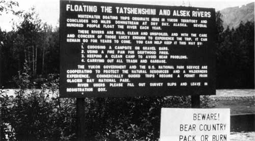
| Floating the Tatshenshini and Alsek rivers began in the 1970s. By 1985, when this photo was taken, hundreds of people made the trip annually. Photo by Ted Handwerk, seasonal ranger at Dry Bay. (GLBA Collection, photo X-355-3.) |
|
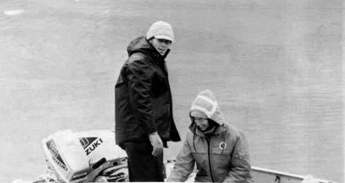
| Mike Tollefson, shown here in a June 1986 shot with his wife Judy, served as Glacier Bay's superintendent from 1983 through 1987. Photo taken by NPS seasonal interpreter Rosemarie Salazar. (Salazar Collection.) |
|
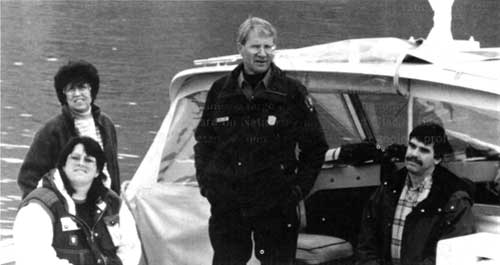
| Marvin Jensen (center) served as Glacier Bay's superintendent from 1988 through 1994. Shown with Jensen in this September 1994 photo, taken aboard the Serac, are regional office employees Ruth Poff (standing), Teri Hudgins, and Tom Ferranti. (Marvin Jensen Collection.) |
| <<< Previous | <<< Contents>>> | Next >>> |
adhi/chap13.htm
Last Updated: 24-Sep-2000