|
GLACIER BAY
Land Reborn: A History of Administration and Visitor Use in Glacier Bay National Park and Preserve |

|
Appendix A:
Legislation And Proclamations
Executive Order, May 2, 1918
Executive Order, August 16, 1918
Executive Order, April 1, 1924
Proclamation, February 26, 1925
Act of June 22, 1936
Proclamation, April 18, 1939
Public Land Order, September 30, 1943
Public Land Order, December 9, 1949
Proclamation, March 31, 1955
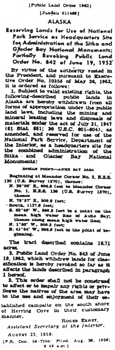
Public Land Order, August 25, 1959
Act of September 28, 1976
Proclamation, December 1, 1978
|
Under authority of the Act of Congress approved June 25, 1910 (36 Stat., 847), as amended by the Act of August 24, 1912 (37 Stat., 497), it is hereby ordered that the tract of land in Alaska extending ten miles back from the tide line around Lituya Bay, containing approximately 312 square miles, be and the same is hereby, temporarily withdrawn from settlement, location, sale or entry, except as provided by said Acts, for the purpose of supplying timber for use in the construction of aeroplanes for the United States. WOODROW WILSON THE WHITE HOUSE, [No. 2854.] |
|
Under authority of the Act of Congress approved June 23, 1910 (36 Stat., 847), as amended by the Act of August 24, 1912 (37 Stat., 497), it is hereby ordered that, with a view of enlarging the withdrawal made by executive order of May 2, 1918 (2854), the tract of land in Alaska lying south of the parallel of 58 degrees 50 minutes north latitude and west of the meridian of 137 degrees 40 minutes west longitude, and bounded on the west by the waters of the Gulf of Alaska, be, and the same is hereby, temporarily withdrawn from settlement, location, sale or entry, except as provided by said act, for the purpose of supplying timber for use in the construction of aeroplanes for the United States. WOODROW WILSON THE WHITE HOUSE, [No. 2935.] |
|
ALASKA It is hereby ordered, under authority of the act of Congress approved June 25, 1910 (36 Stat., 847), as amended by the act of August 24, 1912 (37 Stat., 497), that the public lands lying within the hereinafter described boundaries be, and they are hereby, temporarily withdrawn pending determination as to the advisability of including the same in a national monument, subject to the conditions of said acts and to all prior claims lawfully initiated and maintained: Beginning at the western extremity of Cape Fairweather on the west coast of Alaska, thence in a northeasterly direction to the summit of Mt. Fairweather on the international boundary between Canada and the United States, thence following such boundary easterly, northeasterly and easterly to Monument No. 157 of the survey of such boundary by the International Boundary Commission approved June 9, 1923; thence east following the latitude of said monument to an intersection with the right bank of Chilkat Inlet; thence southerly along the right banks of said inlet and Lynn Canal to Icy Strait; thence westerly along the north shores of Icy Strait and Cross Sound to the Pacific Ocean; thence in a general northwesterly direction along the shore of the Pacific Ocean to Cape Fairweather, the place of beginning. containing approximately 2,560,000 acres. CALVIN COOLIDGE THE WHITE HOUSE, [No. 3983.] |

(click on image for a PDF version)
|
Glacier Bay National Monument, Alaska. Permission for mining within, granted. Use of surface land. |
An Act To permit mining within the Glacier Bay National Monument, approved June 22, 1936 (49 Stat. 1817) Be it enacted by the Senate and House of Representatives of the United States of America in Congress assembled, That in the area within the Glacier Bay National Monument in Alaska, or as it may hereafter be extended all mineral deposits of the classes and kinds now subject to location, entry, and patent under the mining laws of the United States shall be, exclusive of the land containing them, subject to disposal under such laws, with right of use of occupation and use of so much of the surface of the land surface land as may be required for all purposes reasonably incident to the mining or removal of the minerals and under such general regulations as may be prescribed by the Secretary of the Interior. |
|
PROCLAMATION 2330 EXCLUDING CERTAIN LANDS FROM THE TONGASS NATIONAL FOREST AND ADDING THEM AND OTHER LANDS TO THE GLACIER BAY NATIONAL MONUMENT—ALASKA WHEREAS it appears that certain public lands, part of which are within the Tongass National Forest, adjacent to the Glacier Bay National Monument, in Alaska, have situated thereon glaciers and geologic features of scientific interest; and WHEREAS a portion of the aforesaid public lands contiguous to the said monument are necessary for the proper care, management, and protection of the objects of scientific interest situated on the lands included within the said monument; and WHEREAS it appears that it would be in the public interest to reserve all of the aforesaid public lands as a part of the said monument: NOW, THEREFORE, I, FRANKLIN D. ROOSEVELT, President of the United States of America, under and by virtue of the authority vested in me by the act of June 4, 1897, 30 Stat. 11, 34, 36 (U. S. C., title 16, sec. 473), and the act of June 8, 1906. c. 3060, 34 Stat. 225 (U. S. C., title 16, sec. 431), do proclaim that all of the following-described lands which lie within the Tongass National Forest, in Alaska, are excluded there from, and that, subject to valid existing rights, all the following-described lands in Alaska are hereby added to and made a part of the said Glacier Bay National Monument: Beginning at the summit of Mount Fairweather, on the International Boundary line between Alaska and British Columbia; thence southeasterly along present southern boundary of Glacier Bay National Monument to the point of the divide between the waters of Glacier Bay and Lynn Canal where said divide is forked by the headwaters of Excursion Inlet; thence easterly and southeasterly along the divide between the waters of Excursion Inlet and Lynn Canal to a point in approximate latitude 68°27' N.. longitude 135°18' W., where said divide meets a subsidiary divide between streams flowing into Excursion Inlet; thence westerly and northwesterly along said subsidiary divide to the east shore of Excursion Inlet; thence due west to the center of the principal channel of Excursion Inlet: thence southerly along the center of the principal channel of Excursion Inlet to its junction with the Icy Passage: thence westerly and southwesterly along the center of Icy Passage, North Passage, North Indian Pass, and Cross Sound to the Pacific Ocean; thence northwesterly following the general contour of the coast at a distance of 3 nautical miles therefrom to a point due west of the mouth of Seaotter Creek: thence due east to the north bank of Seaotter Creek and easterly along the north bank of Seaotter Creek to its headwaters; thence in a straight line to the summit of Mount Fairweather, the place of beginning. Containing approximately 904,960 acres. Warning is hereby expressly given to all unauthorized persons not to appropriate, injure, destroy, or remove any feature of this monument and not to locate or settle upon any of the lands thereof. The Director of the National Park Service, under the direction of the Secretary of the Interior, shall have the supervision, management, and control of the monument as provided in the act of Congress entitled "An Act to establish a National Park Service, and for other purposes." approved August 25, 1916, 39 Stat. 535 (U. S. C., title 16, sess. 1 and 2), and acts supplementary thereto or amendatory thereof. IN WITNESS WHEREOF I have here unto set my hand and caused the seal of the United States to be affixed.
DONE at the City of Washington this 18 day of April in the year of our Lord nineteen hundred and thirty-nine, and of the Independence of the United States of America the one hundred and sixty-third. FRANKLIN D ROOSEVELT By the President: |
|
[Public Land Order 177] ALASKA WITHDRAWING PUBLIC LANDS FOR USE OF THE WAR DEPARTMENT FOR MILITARY PURPOSES By virtue of the authority vested in the President and pursuant to Executive Order No. 9537 of April 24, 1943, it is ordered as follows: Subject to valid existing rights, the public lands within the following described areas are hereby withdrawn from all forms of appropriation under the public-land laws, including the mining and mineral-leasing laws, and reserved for the use of the War Department for military purposes: TRACT No. 1 Beginning at a point, latitude 58°40'00" N., longitude 135°40'00" W. From the initial point by metes and bounds. East, 4.75 miles. along the parallel of latitude to an intersection with the boundary between the Tongass National Forest and the Glacier Bay National Monument described in Proclamation No. 2330, April 18, 1933 (53 Stat. 2534); Southeasterly, 18.5 miles, along said boundary to latitude 58°27'00" N., longitude approximately 135°18' W.; S. 20°30' E., 8.25 miles. to the headwaters of a stream, latitude 55°20'18" N., longitude 135°13'20" w.; Southeasterly, 9.25 miles, downstream along the right bank of said stream to its mouth, from which the northwesterly end of Ansley Island bears S. 20° E., 0.75 miles; Northwesterly, 80 miles, along the shoes of Icy Strait, Excursion Inlet, Icy Passage, Glacier Bay and Bartlett cove at ordinary high tide, to the mouth of Bartlett River; Northeasterly, 11 miles, upstream along the left bank of Bartlett River at ordinary high water to latitude 58°37' N.. longitude approximately 135°41'30" W.; East, 1 mile, to meridian of longitude 135°40'00" W.; North, 2.46 miles, along the meridian to the point of beginning. The area described, including both public and non-public lands, aggregates 219,000 acres. TRACT No. 2 Pleasant Island, containing approximately 11,000 acres, Located on the north side of Icy Strait between the mouth of Glacier Bay and the mouth of Excursion Inlet, Latitude 58°21'25" N., longitude 135°38"48" W. TRACT No. 3 Four small islands known as Porpoise Islands, containing approximately 120 acres, Located on the north side of Icy Strait; near the mouth of Excursion Inlet. latitude 58°20'00" N., longitude 135°27'54" W. TRACT No. 4 All that part of Point Adolphus, Chicagof Island, on the south side of Icy Strait. lying north of latitude 58°15'00" N., containing approximately 4,550 acres. This order shall be subject to the withdrawal for lighthouse purposes made by Executive Order No. 3406 of February 13, 1921, Area No. 158, so far as such order affects the land in Tract No. 4. This order shall take precedence over but not modify (1) the Proclamation of June 25, 1910 (44 Stat. 2578) changing the boundaries of the Tongass National Forest so as to include and exclude certain lands, and (2) Proclamation No. 2330 of April 18. 1939 (53 Stat. 2534), adding certain lands to the Glacier Bay National Monument, so far as such Proclamations affect any of use lands herein described. In connection with the use by the War Department of the lands within the Glacier Bay National Monument, wherever possible the natural features of the Monument, including forests, wildlife. and objects of geological or historical nature, shall remain unmolested. Upon the termination of the use of the Glacier Bay National Monument area by the War Department, all buildings and other structures except those of a strictly military technical character, erected thereon by the War Department, shall be transferred to the Department of the Interior, or shall be removed by the War Department and the sites restored as nearly as possible to their condition at the time of the issuance of this order, at the option of the Secretary of the Interior. Structures of a strictly military technical nature. the disposition of which is not otherwise provided for, shall he removed by the War Department at the expiration of the need for the same, and the sites shall be restored as nearly as possible to their condition at the time of the issuance of this order. The use of the Glacier Bay National Monument lands may be terminated at any time in the discretion of the Secretary of the Interior, subject to the approval of the President of the United States. The jurisdiction granted by this order over the remaining public lands within the above-described areas shall cease at the expiration of the six months' period following the termination of the unlimited national emergency declared by Proclamation No. 2487 of May 27, 1941 (55 Stat. 1647). Thereupon, jurisdiction over such lands shall be vested in the Department of the Interior, and any other Department or agency of the Federal Government according to their respective interests then of record. Such lands, however shall remain withdrawn from appropriation as herein provided until otherwise ordered. Subject to limitations imposed by reason of actual military necessity, native groups and individual natives may continue to utilize the lands described in this order for hunting, trapping, fishing, and other activities upon which their livelihood depends. This order is confidential and shall not be filed in the Division of the Federal Register, or be published in the FEDERAL REGISTER, or be given other publicity until publication thereof has been expressly authorized by or at the direction of the Secretary of War. NOTE: Confidential status released by letter of the Secretary of War dated June 27, 1946. ABE FORTAS, SEPTEMBER 30, 1943. [F. R. Doc. 45—133 16: Filed, July 31, 1946: 4:08 p. m.] |

(click on image for a PDF version)
|
PROCLAMATION 3089 EXCLUDING CERTAIN LANDS FROM THE GLACIER BAY NATIONAL MONUMENT AND ADDING A PORTION THEREOF TO THE TONGASS NATIONAL FOREST—ALASKA WHEREAS certain lands Comprising a portion of the hereinafter-described Gustavus Area of the Glacier Bay National Monument in Alaska, established by Proclamation No. 1733 of February 26, 1925 (43 Stat. 1988), and enlarged by Proclamation No. 23301 of April 18, 1939 (53 Stat. 2534), are now being used as an airfield for national-defense purposes and are no longer suitable for national-monument purposes; and WHEREAS the other lands within the Gustavus Area, including several homesteads which were patented prior to the enlargement of the monument by the proclamation of April 18, 1939, are suitable for a limited type of agricultural use and are no longer necessary for the proper care and management of the objects of scientific interest on the lands within the monument: and WHEREAS the lands comprising the hereinafter-described Excursion Inlet Area of the monument were erroneously excluded from the Tongass National Forest and included in the monument by the proclamation of April 18, 1939, and such lands are suitable for national forest purposes: and WHEREAS it appears that it would be in the public interest to exclude the said lands comprising the Gustavus Area and the Excursion Inlet Area from the Glacier Bay National Monument, and to restore the lands within the Excursion Inlet Area to the Tongass National Forest: NOW, THEREFORE, I, DWIGHT D. EISENHOWER, President of the United States of America, under and by virtue of the authority vested in me by section 2 of the act of June 8, 1908, c. 3060, 34 Stat. 225 (16 U. S. C. 431), section 24 of the act of March 3, 1891, 26 Stat. 1103 (16 U. S. C. 471), and section 1 of the act of June 4, 1897, 30 Stat, 34, 36 (18 U. S. C. 473), do proclaim (1) that all of the following-described lands in the Territory of Alaska are hereby excluded from the Glacier Bay National Monument and (2) that, subject to all valid existing rights, those lands designated and described as the Excursion Inlet Area are hereby added to and made a part of the Tongass National Forest and shall be subject to all laws, rules, and regulations applicable to that forest: GUSTAVUS AREA COPPER RIVER MERIDIAN T. 40 S., R. 58 E., T. 40 S., R. 59 E., Also, a parcel of unsurveyed land described as follows; Beginning at the northwest corner of sec. 1, T. 40 S., R. 58 E., C.R.M,: thence North 7.920 feet; East 2,640 feet; South 45°00' East to the northeast corner of sec. 6, T. 40 S., R. 59 E. C. R. M.; West, along the northern boundary of sec. 6, T. 40 S., R. 59 E., and sec. 1, T. 40 S., R. 58 E., C. R. M., to the point of beginning. Also, all water and islands lying directly south and offshore between the above-described lands and the center of Icy Passage. The areas described, including both public and nonpublic lands, aggregate approximately 14,741 acres of land and 4,193 acres of water. EXCURSION INLET AREA A tract of unsurveyed land described as follows: Beginning at a point on the center line of the principal channel of Excursion Inlet from which Corner No. 1 M. C. of United States Survey No. 666 bears due east; thence Northerly along the center of the principal channel of Excursion Inlet to a point in approximate latitude 55°30' N., longitude 135°30' W.: East to the east shore of Excursion Inlet: Northeasterly, southeasterly, and easterly, along a subsidiary divide between two streams flowing into Excursion Inlet, to the divide between the waters of Excursion Inlet and Lynn Canal in approximate latitude 58°29'30" N., longitude 135°20' W.; Southerly along said divide to a point in approximate latitude 58°27' N., longitude 135°18' W.: Westerly along a subsidiary divide between two streams flowing into Excursion Inlet to the east shore of said Inlet; West to the center of the principal channel of Excursion Inlet; Northerly along the center of the principal channel of Excursion Inlet to the point of beginning. The area described, including both public and nonpublic lands, aggregates approximately 10,184 acres. The lands in the above-described Gustavus Area shall not be subject to application, location, settlement, entry, or other forms of appropriation under the public land laws until further order of an authorized officer of the Department of the Interior. The said Proclamation No. 2330 of April 18, 1939, is amended accordingly. IN WITNESS WHEREOF I have here unto set my hand and caused the seal of the United States of America to be affixed.
DONE at the City of Washington this 31st day of March in the year of our Lord nineteen hundred and fifty-five, and of the Independence of the United States of America the one hundred and seventy-ninth. DWIGHT D. EISENHOWER By the President: 13 CFR 1943 Cum. Supp. |
(click on image for a PDF version)

(click on image for a PDF version)
| THE PRESIDENT | |
| [3195—01—M] | |
| Proclamation 4618 | December 1, 1978 |
|
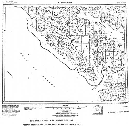
Enlarging the Glacier Bay National Monument By the President of the United States of America A Proclamation Glacier Bay National Monument was created by Presidential Proclamation in 1925 and was enlarged in 1939 and again in 1955. It protects the great tidewater glaciers and a dramatic range of plant communities. The enlargement accomplished by this Proclamation furthers the protection of the array of geological and ecological interests in the area. This addition includes the northwesterly side of Mount Fairweather, the highest peak in this part of Alaska, and the Grand Plateau Glacier, both significant to students of glaciology. The Alsek River corridor provides the only pass through the coastal mountain range for 120 miles, This is the route by which large mammals first entered this isolated area and is used by a significant percentage of the Alaska bald eagle population en route to the Klukwan area where they winter. The addition also protects two botanically significant areas. In the hills flanking Grand Plateau Glacier live the oldest plant communities in southeast Alaska which survive because the area escaped both glaciation and inundation. Also important to the study of ecological succession are the mature aquatic vegetative communities of the pre-neoglacial lakes in the Deception Hills area. The land withdrawn and reserved by this Proclamation for the protection of the geological, biological, and other phenomena enumerated above supports now, as it has in the past, a unique subsistence culture of the local residents. The continued existence of this culture, which depends on subsistence hunting, and its availability for study, enhances the historic and scientific values of the natural objects protected herein because of the ongoing interaction of the subsistence culture with those objects. Accordingly, the opportunity for local residents to engage in subsistence hunting is a value to be protected and will continue under the administration of the area added to the Glacier Bay National Monument by this Proclamation. Section 2 of the Act of June 8, 1906 (34 Stat, 225, 16 U.S.C. 431), authorizes the President, in his discretion, to declare by public proclamation historic landmarks, historic and prehistoric structures and other objects of historic or scientific interest that are situated upon the lands owned or controlled by the Government of the United States to be national monuments, and to reserve as part thereof parcels of land, the limits of which in all cases shall be confined to the smallest area compatible with the proper care and management of the objects to be protected. NOW, THEREFORE, I, JIMMY CARTER, President of the United States of America, by the authority vested in me by Section 2 of the Act of June 8, 1906 (34 Stat. 225, 16 U.S.C. 431), do proclaim that there are hereby set apart and reserved for inclusion in the Glacier Bay National Monument all lands, including submerged lands, and waters owned or controlled by the United States within the boundaries of the area depicted as the Enlargement of Glacier Bay National Monument on the map numbered GLBA—90,005 attached to and forming a part of this Proclamation. The area reserved consists of approximately 550,000 acres, and is necessary to ensure the proper care and management of the objects the monument was established to preserve and those added by this Proclamation. Lands, including submerged lands, and waters within these boundaries not owned by the United States shall be reserved as a part of the monument upon acquisition of title thereto by the United States. All lands, including submerged lands, and all waters within the boundaries of this addition are hereby appropriated and withdrawn from entry, location, selection, sale or other disposition. other than exchange. There is also reserved all water necessary to the proper care and management of those objects protected by this monument and for the proper administration of the monument in accordance with applicable laws. The establishment of this addition is subject to valid existing rights, including, but not limited to valid selections under the Alaska Native Claims Settlement Act, as amended (43 U.S.C. 1601 et seq.), and under or confirmed in the Alaska Statehood Act (48 U.S.C. Note preceding Section 21). Nothing in this Proclamation shall be deemed to revoke any existing withdrawal, reservation or appropriation, including any withdrawal under Section 17(d)(1) of the Alaska Native Claims Settlement Act, (43 U.S.C. 1616(d)(1)); however, the national monument shall be the dominant reservation. Furthermore, nothing in this Proclamation is intended to modify or revoke the terms of the Memorandum of Understanding dated September 1, 1972. entered into between the State of Alaska and the United States as part of the negotiated settlement of Alaska v. Morton, Civil No. A—48—72 (D. Alaska, Complaint filed April 10, 1972). The Secretary of the Interior shall promulgate such regulations as are appropriate, including regulation of the opportunity to engage in a subsistence lifestyle by local residents. The Secretary may close this addition, or any portion thereof, to subsistence uses of a particular fish, wildlife or plant population if necessary for reasons of public safety, administration, or to ensure the natural stability or continued viability of such population. Warning is hereby given to all unauthorized persons not to appropriate, injure, destroy or remove any feature of this monument and not to locate or settle upon any of the lands thereof. IN WITNESS WHEREOF, I have hereunto set my hand this 1st day of December, in the year of our Lord nineteen hundred and seventy-eight, and of the Independence of the United States of America the two hundred and third. Jimmy Carter FEDERAL REGISTER, VOL 43, NO. 234—TUESDAY, DECEMBER 5, 1978
| |
| <<< Previous | <<< Contents>>> | Next >>> |
adhi/appa.htm
Last Updated: 24-Sep-2000