
|
Washington Department of Natural Resources Geology and Earth Resources Division Bulletin No. 66 Geology of the Washington Coast between Point Grenville and the Hoh River |
PART II
Geologic Observations and Interpretations Along Segments of the Coast
HOH RIVER AREA
In the low-lying bluffs, for a distance of about one-half of a mile south of the Hoh Indian village, Hoh rocks are poorly exposed in a few isolated outcrops beneath deposits of sand and gravel. Erosional remnants of sandstone boulders are scattered on the beach in this area. Here, as in the Abbey Island area, Hoh rocks are structurally complex. Thin-bedded sandstone and siltstone strata are well exposed immediately south of the village where the complexity of the structure is particularly apparent. Additional outcrops of Hoh rocks, mostly massive graywacke sandstones, are present on both sides of the Hoh River.
One of the few outcrop areas where marine fossils are known to occur in Hoh rocks is located about 1-1/2 miles upstream on the north side of the river. A few of the more common species known from there have been identified by Dr. Warren O. Addicott of the U.S. Geological Survey and are listed on page 6. According to Dr. Addicott, these fossils lived in a relatively shallow marine environment, possibly at depths between 30 and 100 feet during the Miocene Epoch (see Geologic time chart, fig. 2).
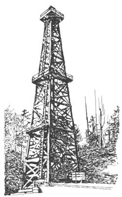
In the same vicinity a major oil and gas test well was drilled in 1965 to a depth of 5,015 feet. According to information from well logs, much of it was drilled in sandstone and some beds of siltstone. Significant gas was encountered, particularly near the bottom of the hole, but in subcommercial quantities. This, however, was not the first attempt at petroleum production in the Hoh River area. At least eleven shallow wells, for which there are records, were drilled in an area about 1-1/2 miles northeast of the mouth of the Hoh River in the vicinity of the Jefferson oil seep (fig. 60). Most of these wells were drilled to a depth of less than 1,000 feet. Although none produced commercial quantities of oil or gas, shows of petroleum were recorded in nearly all. Two eras of drilling took place near here, the earliest of which started in 1913. At that time the drilling equipment was brought in from ships through the surf at Jefferson Cove, and then dragged up the bluffs to the drilling site a mile or so inland. The second period of drilling began in the early 1930's, during which time slightly deeper wells were drilled. The deepest penetrated 2,155 feet of Hoh rocks. Another well was drilled in the 1930's near the Lacy oil seep, some five miles northeast of the mouth of the Hoh River, but without commercial success. In 1948, a major company drilled to a depth of 5,600 feet on the south side of the Hoh River, some 3 miles upstream from its mouth. Again, however, only minor shows of gas were reported.
Thus, the lower Hoh River area has had a history of considerable petroleum exploration, most of which was prompted by the presence of several oil seeps. Remaining evidence of these days of exploration optimism can still be seen on maps and highway signs where the name "Oil City" is used to refer to a platted, but essentially nonexistent, community near the mouth of the Hoh River.
| <<< Previous | <<< Contents >>> | Next >>> |
state/wa/1973-66/sec2-15.htm
Last Updated: 28-Mar-2006