|
Washington Department of Natural Resources Geology and Earth Resources Division Bulletin No. 66 Geology of the Washington Coast between Point Grenville and the Hoh River |
PART II
Geologic Observations and Interpretations Along Segments of the Coast
RUBY BEACH-ABBEY ISLAND
BEDROCK
Extending from Wet Foot Point, immediately south of Ruby Beach (fig. 62), northward to nearly the mouth of Cedar Creek, a distance of about one-half a mile, massive, badly fractured sandstone is exposed in the lower 50 feet of the cliffs and in both onshore and offshore stacks and low rocks. These are also outcrops of Hoh rocks. In places the sandstone is very coarse grained, consisting of grit-sized pebbles. White chert or quartz pebbles are particularly noticeable. As are most of the Hoh standstones, these strata are composed of many fragments of various rock types and are therefore classified as graywacke sandstone.
In this area Hoh rocks have undergone considerable deformation and have been highly fractured. Most of the fractures have since been filled with secondary minerals, largely calcite, forming thin white veins.
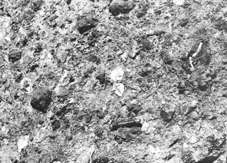
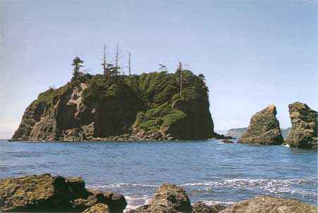
A somewhat different rock type is exposed north of the mouth of Cedar Creek in beach stacks, in the base of the cliff, and on Abbey Island (fig. 71). Here, the rocks are primarily volcanic in origin although many clasts of sedimentary rocks can be found within them. Generally, the rocks of this area are classified as "volcanic breccia" (fig. 69). Most likely they were formed when volcanic materials were ejected onto the sea floor where they cooled rapidly, forming much angular volcanic rubble that, in turn, was incorporated with sediments already on the sea floor. All of these materials have since been welded together by heat, pressure, and secondary mineralization. Some of the rock types that can be seen in this agglomerated rock unit are various volcanic rocks including volcanic glass, amygdaloidal and vesicular basalt and tuff, together with clasts of sedimentary rocks including white, green, and red chert, argillite, and sandstone. Some time following the consolidation of this rock unit, it was fractured, but subsequently it has been recemented with secondary minerals, largely calcite, much like the sandstone of Ruby Beach. Numerous thin white veins can therefore be seen in rocks of Abbey Island as well as other nearby outcrops.
Structural and stratigraphic relations of Hoh rocks in the Ruby Beach-Abbey Island area are very complex. Attempts by geologists to unravel details of the geologic history of these rocks have been based largely on conjecture and conclusions are therefore hypothetical. It is apparent that Hoh rocks of this area have undergone considerable deformation. The presence of volcanic rocks in an unknown relation with an otherwise sedimentary section suggests that crustal movement may have brought these two different rock types in juxtaposition. Some geologists, therefore, postulate that a major fracture or fault zone may pass through this area. Others suggest that the bedrock of this area represents huge blocks of contorted resistant rock within a "melange" or mixture of rocks (see Part I, Tectonic melange of the Hoh rock assemblage). On the latter basis, the rocks of this area can be compared with those of the Hogsbacks area, where large resistant blocks, mostly of sandstone and volcanic material, are set in a matrix of relatively soft, contorted clay and siltstone (see Part II, The Hogsbacks area). Regardless of how the Ruby Beach-Abbey Island bedrock became structurally complex, it is apparent that these rocks have undergone much deformation from great amounts of force, and that a history of considerable crustal movement during the past 20 million years or so is represented in rocks of this area.
SAND AND GRAVEL DEPOSITS
In most of the Ruby Beach-Abbey Island area bedrock extends upward in the cliffs between 30 and 60 feet above beach level. The generally level line formed on top of bedrock represents the trace of the Pleistocene wave-cut surface that also occurs in many places to the south. Ancient piddock clam borings, essentially identical to those found today only at tidal level, can be seen on this surface on the south side of Abbey Island some 50 feet above present-day sea level. Bedrock knobs that stand above the old elevated level were offshore stacks or promontories of land during that time. Outwash sand and gravels, distributed by streams from glaciers of the Pleistocene Epoch, cover the old wave-cut surface and form the remainder of the cliffs, which in this area, measure over 100 feet in height. Some of these deposits also form an upper part of Abbey Island.
The name "Ruby Beach" is derived from reddish colored patches of sand that are particularly prevalent in this area. This color is due to concentrations of individual crystals of the relatively heavy, red-colored mineral, garnet (see Part II, Hogsbacks area, Red beach sand).

|
| BEDROCK OF ABBEY ISLAND. It consists mostly of angular fragments of volcanic material and some sedimentary rock, all of which are welded together to form a solid rock mass. Such material is called volcanic breccia. (Fig. 69) |
ABBEY ISLAND TO THE HOH RIVER
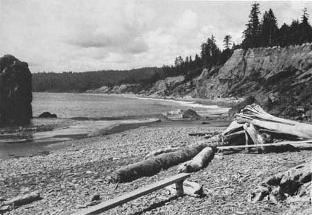
For a distance of nearly 2-1/2 miles northward from Abbey Island to the Hoh River, high cliffs, in many places towering over 150 feet above the beach, expose both bedrock of Hoh rocks and large continuous outcrops of sand and gravel of late Cenozoic age (fig. 70). The highly fractured and structurally complex outcrops of Hoh rocks of the Ruby Beach-Abbey Island area extend northward from the volcanic rocks of Abbey Island for over half a mile. Various rock types are exposed in the lower 50 feet or so of the cliffs and in several large low-tide outcrops. They include both highly sheared siltstone and large bodies of massive broken sandstone. Siltstone outcrops are similar to the intensely sheared and jumbled Hoh rocks that are exposed in several places to the south (see Part II, The Hogsbacks area), and the sandstones are comparable to those of the Ruby Beach area.

|
| LOOKING NORTHWARD FROM THE ABBEY ISLAND AREA. In places, contorted Hoh rocks crop out at the base of the cliffs beneath thick deposits of sand and gravel of the Pleistocene Epoch. (Fig. 70) |

|
| ABBEY ISLAND with Hoh Head in the distance. The basal part of the island is largely volcanic rock with some included fragments of sedimentary rock. Bedrock materials are overlain by sand and gravel deposits, some 50 feet thick. (Fig. 71) |
The trace of the ancient wave-cut surface, visible in the Ruby Beach area and many other places to the south, is also seen here at the top of the bedrock some 50 feet above the beach. Sand and gravel deposits of late Pleistocene age overlie bedrock and, in places, are at least 100 feet thick.
At the north end of the bedrock outcrops, about one-half of a mile north of Abbey Island, a dark gray semiconsolidated mixture of clay, sand, and boulders is exposed in the lower part of the cliffs. These materials most likely were deposited directly from glacial ice with very little, if any, reworking by streams from the glaciers. A few hundred feet to the north, these poorly sorted materials are overlain by typical lakebed deposits of fine-grained gray, thin-bedded silts and clays. Outcrops of these well-stratified sediments continue northward for a considerable distance. From the relations seen in this immediate area it appears that the poorly sorted materials were deposited directly from a glacier into a body of water, perhaps a lake. Subsequently, normal lake deposition of fine materials resumed and at least partially buried the glacially derived deposits. In this same area a thickness of some 20 feet of orange-colored sands overlie the gray-colored sediments. A few cobbles are scattered along the trace of the nearly horizontal upper surface of these orange-colored sands, marking the continuation of the old wave-cut surface that, to the south, was formed on the bedrock of Hoh rocks. All sand and gravel above this line of cobbles was deposited by streams flowing from one of the last of the Pleistocene glaciers to occupy nearby valleys to the east.
Northward for overhalf a mile to a place about 1-1/4 miles north of Abbey Island, the cliffs are prominently broken with landslides. Extremely large areas of the upper sand and gravel unit are slumped downward and rotated away from the scarp that has been formed several hundred feet inland from the coastline. Drunken forests are prevalent in this large area, indicating movement of the surface during the life span of the trees. This slumping most likely has resulted from movement of large masses of sand and gravel on the underlying soft, somewhat greasy, laminated clay and silt unit, part of which is exposed immediately to the south of the slumped area.
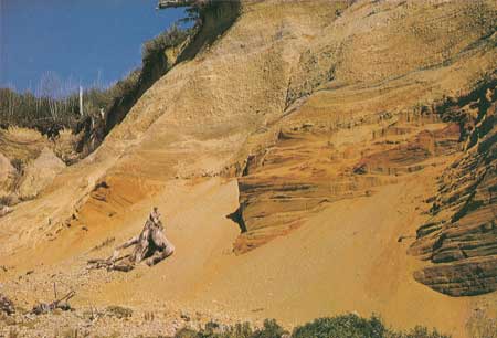
To the north of this large area of landslides, the cliffs, towering nearly 150 feet above the beach, display relatively undisturbed deposits of Pleistocene silt, sand, and gravel. Here the trace of the Pleistocene wave-cut surface is well marked by a line of boulders some 50 feet above the beach. Fine-grained, well-laminated, gray-colored materials, similar to those at the base of the cliffs south of the landslide area, also form the base of these cliffs. They are overlain by very colorful, reddish-orange, parallel and cross-laminated sands (fig. 72), materials that were probably formed as beach or dunelike deposits during the Pleistocene Epoch. These sands extend upward to the line of boulders and cobbles that separates them from later Pleistocene glaciofluvial materials above. In places these latter deposits measure nearly 100 feet in thickness.

|
| COLORFUL DEPOSITS OF SAND AND GRAVEL exposed in the cliffs about one mile south of the Hoh River. Beach and dunelike deposits are represented in the lower unit of sand, whereas the gravels in the upper part of the cliff probably were deposited by streams. The nearly horizontal line of cobbles and boulders separating the two deposits represents the trace of an elevated surface that was formed on the lower deposits sometime during the Pleistocene Epoch. (Fig. 72) |
Both units above and below the boulder layer are well displayed in the cliffs northward for nearly three-quarters of a mile. Toward the north, the boulder layer gradually rises in height above the beach to an elevation of at least 75 feet. However, the total height of the cliff becomes less to the north because, in this area, the land surface has been lowered by erosion to form the south side of the Hoh valley. Therefore, the thickness of outcrop of the upper unit has been reduced. Farther north all of the upper unit has been removed and only a part of the lower unit remains. In the northernmost area of these deposits, about half a mile south of the Hoh Indian village, only beds of the lower laminated gray silt and clay are left to form the low-lying bluffs. The gradual but noticeable rise northward in the height of the trace of the boulder-covered wave-cut surface indicates that since it was first formed sometime during the late Pleistocene it, as well as the materials beneath, have been slightly upwarped.
Present-day beach deposits in much of the area between Abbey Island and the Hoh River are continually replenished from the Pleistocene materials of the adjacent cliffs. They have been moderately reworked by wave action of winter storms; the finer fractions of the deposits including fine pebbles, sand, and silt have been removed and deposited farther seaward.
| <<< Previous | <<< Contents >>> | Next >>> |
state/wa/1973-66/sec2-14.htm
Last Updated: 28-Mar-2006