
|
Washington Department of Natural Resources Geology and Earth Resources Division Bulletin No. 66 Geology of the Washington Coast between Point Grenville and the Hoh River |
PART II
Geologic Observations and Interpretations Along Segments of the Coast
BROWNS POINT-STARFISH POINT AREA
BROWNS POINT-BEACH TRAIL 3 AREA
Bedrock
About 2 miles north of Kalaloch and in the vicinity of Beach Trail 3 (fig. 59), a major series of bedrock outcrops form the headland known as Browns Point (fig. 6). These rocks, together with those exposed in the vicinity of Starfish Point near Beach Trail 4 (figs. 7 and 65), constitute one of the major coastal outcrop areas of Hoh rocks between Point Grenville and the Hoh River. Locally these strata have been called the Browns Point Formation by some geologists. However, recent studies reveal that they cannot be easily mapped as a separate rock unit in the foothills of the Olympic Mountains to the east and north. Therefore, in this report these strata are still regarded as a part of the Hoh rock assemblage.
|
| QUEETS RIVER TO BEACH TRAIL 4—Coastal Map. (Fig. 59) (click on image for an enlargement in a new window) |
In the Browns Point-Starfish Point area Hoh rocks are composed of a series of steeply eastward-dipping massive to thin-bedded sandstones and siltstones representing a nearly continuously exposed sequence of sedimentary strata, measuring nearly 2,000 feet in thickness. Although the beds dip eastward some 40° to 65° from horizontal, sedimentary structures (fig. 9), particularly abundant and well formed in this area, indicate that the youngest beds of the sequence are to the west. Therefore all beds have been rotated beyond vertical to an overturned position. According to paleontologists, the few fossils that have been found in these rocks indicate that they were deposited some 15 to 22 million years ago in a deep ocean basin somewhere west of our present-day coastline (see Part I, Interpretations of structure in the Hoh rock assemblage). Furthermore, many of these strata were formed by the settling of sediments from turbid waters created largely by the repeated slumping of large masses of sediments. Geologists therefore refer to these sedimentary rocks as "turbidites." The resulting deposits are basically a series of bedded sandstone and siltstone in which a grading of grain size occurs from sand-size sediments of sandstone to silt-size particles in siltstone. The numerous beds of sandstone and siltstone exposed locally represent a repetition of many similar events of deposition.
Thick units of predominantly siltstone laminated with only an occasional thin bed of sandstone represent periods of normal deposition, interrupted by infrequent and short periods of coarse-grain deposition. Examples of such deposition can be seen at times when the beach is cleaned of sand in the saddle between the Browns Point headland and the high-tide area (see Part I, Turbidites of the Hoh rocks).
Numerous northwest-trending faults in the rock can be easily traced, particularly in the low-tide outcrops at Beach Trail 3 and immediately to the north. Displacements on most of these faults are only a few feet and almost all show left lateral movement (the north side of a fracture has moved west relative to the south side). Because these faults usually cut at a decided angle across the bedding, the amount of displacement can be determined if the same strata or sequence of strata is recognized on each side of a fault.
Unconsolidated Deposits
Bedrock in the Browns Point area is overlain by deposits of silt and sand with some 5 to 10 feet of thickness of fine gravel near the base (fig. 64). Several highly carbonaceous layers, representing swamplike deposits, can also be seen. These unconsolidated deposits were laid down during the latter part of the Pleistocene Epoch (fig. 2) and are a continuation of those exposed in the banks of the Kalaloch area. However, in places, a somewhat greater thickness is visible at Browns Point than at Kalaloch.
The contact between younger materials and the underlying Hoh rocks is roughly a horizontal plane about 20 feet above high tide. Its trace can be seen well in the vicinity of the small natural arch along the upper part of the beach (fig. 60). The roof of this arch is composed of fine gravel and represents about the level of the contact. The surface on bedrock at this level represents an old wave-cut bench that was carved during Pleistocene time, prior to the deposition of the overlying silt, sand, and gravel, some 70,000 or more years ago. Although here the surface is on bedrock, it is believed to be the same surface that was carved on old sand and gravel deposits to the south in the Whale Creek area (see Part II, Raft River to Whale Creek, Older deposits of sand and gravel). Due to downwarping, this surface lies below high-tide level at Kalaloch and therefore cannot be seen in that area. Note the numerous old "pholad" or rock clam borings in many places on this surface in the Browns Point area—evidence that this surface at one time occupied a low-tide position with respect to sea level of that tine. In places bedrock was not completely reduced to sea level and therefore it stood above the old wave-cut level as offshore rocks or sharp promontories. The westernmost high point of Browns Point and much of the inland area to the east of Browns Point are places that stood above sea level at that time.
|
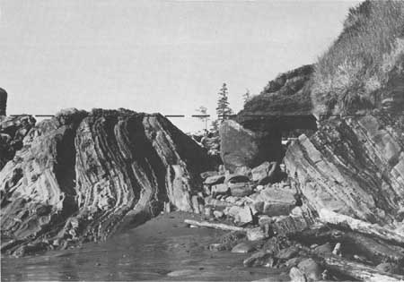
| LOOKING NORTHWARD IN THE BROWNS POINT AREA. Note the roughly horizontal profile as indicated by a dashed line, some 20 feet above beach level, that cuts across steeply dipping sandstone beds of the Hoh rock assemblage. This level represents an elevated wave-cut surface that was carved by the sea during the Pleistocene Epoch. Sand and gravel materials were deposited subsequently on this surface but now are being removed by erosion. The roof and overlying materials of the small natural arch, visible on the right, are some of the Pleistocene deposits that have not yet been removed. (Fig. 60) |
From Beach Trail 3 to Beach Trail 4 sandstone and siltstone beds of the Hoh rocks are exposed in the low-tide area and at the base of the cliff. Old pholad borings are also very common in these rocks about 10 feet above the high-tide level. A thickness of 8 to 10 feet of crudely bedded gravel is present in the banks immediately above the bedrock surface. These gravels may well have been deposited as beach gravels on the old wave-cut beach. Sand and silt beds overlie the gravels and form the upper part of the bluffs.
BEACH TRAIL 4
At the end of Beach Trail 4, steeply eastward-dipping, well-bedded Hoh sandstones are exposed in the basal part of the cliffs and uppermost part of the beach (fig. 8). These strata, like those to the south in the Browns Point area, are typical turbidite sedimentary rocks, and, because the original top of these strata also faces west, they too have been tilted to an overturned position. A southwestern extension of these beds is usually well exposed at low tide (fig. 7). Note how wave action has more deeply eroded the softer siltstone beds, leaving the coarser more resistant sandstone strata as ridges.
A continuation from the south of the younger deposits of silt, sand, and gravel also overlies the bedrock in this area. Their thickness increases northward to at least 80 feet in the Beach Trail 4 area. Again, the old wave-cut surface, which was carved on Hoh rocks during the Pleistocene time, is the contact between bedrock and the younger deposits some 10 to 20 feet above present-day high-tide level. Ancient rock clam borings that were formed when the tidewater once covered this area are abundant at the foot of Beach Trail 4 (fig. 28).
STARFISH POINT
The major headland immediately north of Beach Trail 4, sometimes referred to as Starfish Point (fig. 59), is another rather extensive outcrop of Hoh rocks (fig. 65). Lithologically, it is similar to the coarse-grained sandstone that forms the prominent headland to the south at Browns Point. However, Starfish Point rock is probably stratigraphically above and represents the basal or initial part of another large sequence of turbidite deposition. Note the numerous dark-colored siltstone fragments scattered through much of this sandstone. These and other rock fragments make up a large part of this rock, and therefore geologists also classify it as a graywacke sandstone (see Part 1, Turbidities of the Hoh rocks).
Differential erosion by wave action has shaped this and other rocks of the area. Because of its massiveness and coarse-grained texture, Starfish Point stands more resistant to wave action than the adjacent poorly exposed finer grained and better stratified rocks.
STARFISH POINT TO BEACH TRAIL 5
Another Hoh sequence of sandstone and siltstone is partially exposed in the basal part of the cliffs between Starfish Point and Beach Trail 5. A few outcrops of some of the more resistant sandstone beds are also visible at low tide. These strata are somewhat structurally complex, particularly those near Beach Trail 5. All beds are overturned and generally dip to the southeast.
At Beach Trail 5 and for a few hundred feet to the south, most of the rock is massive pebbly siltstone. These beds are among the very few along the coast where fossils have been found in Hoh rocks. Definitive collections of Foraminifera have been made here from the siltstone and a few megafossils from the nearby sandstones. These fossils indicate to paleontologists that the beds were deposited in a moderately deep marine environment some 15 to 22 million years ago during early Miocene time (fig. 2).
Overlying Pleistocene deposits of sand and silt form much of the sloping bluffs of the area between Starfish Point and Beach Trail 5, but they are only poorly exposed because of the vegetation cover. Note at least one highly carbonaceous layer well above a sand layer. Its presence indicates swamp or shallow pondlike deposition.
| <<< Previous | <<< Contents >>> | Next >>> |
state/wa/1973-66/sec2-11.htm
Last Updated: 28-Mar-2006