
|
Washington Department of Natural Resources Geology and Earth Resources Division Bulletin No. 66 Geology of the Washington Coast between Point Grenville and the Hoh River |
PART II
Geologic Observations and Interpretations Along Segments of the Coast
MOUTH OF QUEETS RIVER VALLEY
The position of the actual mouth of the Queets River has changed over the years as the sea slowly eroded the coastline eastward. At one time the river flowed along the south side of its valley from the town of Queets to nearly the present-day coastline. There, the river turned northward and followed along a west bank, marked today only by the east edge of the low-lying gravel spit extending across much of the mouth of the present-day valley.
At different times in the past the river entered the sea at various places through the spit. One channel, possibly the oldest, extended northward about one-half mile north of the present mouth before reaching the sea. This old channel is now a small elongated pond isolated from the river and sea behind the northernmost part of the old spit.
QUEETS RIVER TO KALALOCH
PLEISTOCENE DEPOSITS
The same unit of late Pleistocene sand and gravel that crops out south of the Queets River also forms much of the low-lying bluffs between the Queets River and Kalaloch. In this area, no more than 50 feet of the uppermost part of this deposit of sand and gravel is exposed above beach level. The upper surface of the gravel gradually appears lower in the bank northward to Kalaloch where only about 8 feet of the uppermost part of the unit is exposed in the lower part of the bank. The upper part of the bank between the Queets River and Kalaloch is largely silt and clay. These latter deposits become thicker northward from the Queets River, and at Kalaloch most of the 30-foot-high bank is composed of silt and clay materials.
The relatively low position of the old piedmont surface (essentially present-day land surface) some 30 feet above sea level may be the result of a broad downwarp of the earth's surface in the Kalaloch area. Further evidence for such a downwarp is the low position of both the top of the sand and gravel deposit near sea level and the Pleistocene wave-cut surface apparently beneath sea level. Accumulations of fine-grained sediments of silt and carbonaceous clay in the Kalaloch area began some 70,000 years ago and have continued essentially to Recent time. This relatively low-lying area was a rather marshy region, receiving only very fine-grained sediments from sluggish streams. Much vegetation probably grew in and around numerous shallow bodies of water. Eventually this vegetation became incorporated in the accumulating fine-grained sediments to form layers of carbonaceous silt and clay now exposed in the banks of the Kalaloch area.
BEACH DEPOSITS OF TODAY
Most deposits along the upper part of the beach are gravels, whereas sand occurs largely in the low-tide areas along much of this part of the coastline. These materials obviously are derived from the older deposits of the adjacent cliffs. Wave action has winnowed the fine materials from the coarse gravels and deposited them farther seaward. Pebbles of the gravels are very largely sandstone but a few are white quartz, red chert, and dense volcanic rock. The sandstone of the pebbles is sometimes referred to as a "graywacke sandstone" (see Part I, Turbidites of the Hoh rocks). Numerous angular fragments of dense dark-gray siltstone can be seen in many of the pebbles (fig. 21). All sand and gravel deposits, which form the bluffs of this area and are the source of the present-day beach deposits, were brought to nearby areas by glaciers during the Pleistocene Epoch (fig. 2), from bedrock outcrops in the Olympic Mountains. These materials were then further distributed and deposited in the immediate area by streams from the melting glaciers to form the deposit now visible in the cliffs. In recent years they have been removed from the cliffs, reshaped, and distributed along the beach by wave action of the present-day sea. The shapes and arrangements of these pebbles are typical of ocean beach deposits. Most of them are somewhat flattened or disclike in shape, and in many places wave action has arranged them in an imbricate or shinglelike manner. This arrangement is sometimes referred to as "beach shingle."
KALALOCH AREA
BEDROCK OUTCROPS
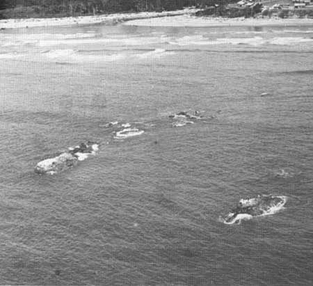
The offshore Kalaloch rocks (fig. 58), together with outcrops in and near the mouth of Kalaloch Creek, are all a part of the Hoh rock assemblage. Based on the depositional history of these rocks, geologists refer to them as "turbidites" (see Part I, Turbidites of the Hoh rocks). Kalaloch is the southernmost area of outcrop of such rocks along the coast. Although structurally complex, they are not completely disarranged as are the "melange" Hoh rocks that are exposed in places to the south (see Part I, Tectonic melange of the Hoh rock assemblage). Turbidite outcrops display sequences of sedimentation that are still intact, and, in places, individual strata can be traced along the beach. The beds dip eastward and have been overturned with the younger strata to the west. Many of these rocks are basically sandstones and conglomerates, but because they contain many fragments of other rocks as well as individual mineral grains, geologists refer to them as "graywackes." Dark-gray siltstone chips are frequently the most conspicuous rock type. Graywacke beds, similar to those that form the turbidite sequences at Kalaloch, are the bedrock source for many of the local present-day beach sand and gravel deposits.
Similar bedrock is much more extensively exposed in several of the headlands immediately to the north of Kalaloch. More detail is presented about these sedimentary rocks in a following discussion on the Browns Point and Starfish Point area.
UNCONSOLIDATED MATERIALS
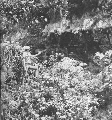
The low-lying bluffs between Kalaloch and Browns Point to the north are composed almost entirely of silt and clay. Several beds are highly carbonaceous and in places, contain large pieces of carbonized wood (fig. 57). These beds, as well as those to the south of Kalaloch, are composed of materials that were deposited in swamps or shallow ponds, the uppermost of which represents one of the last geologic events to take place in this area. Recent detailed studies reveal that the lowest beds exposed locally in the cliff may have been deposited some 70,000 years ago, whereas the uppermost carbonaceous beds are about 17,000 years old (Florer, 1972; Heusser, 1972).
|
| HIGHLY CARBONACEOUS CLAY BEDS exposed in the bluffs north of Kalaloch. These deposits were laid down during the latter part of the Pleistocene Epoch in a swamp environment where clays were mixed with much plant material. In places, concentrations of this vegetation have been converted to "peat," the beginning stages of coal. Studies recently made of these beds indicate that the strata vary in age from about 17,000 to greater than 48,000 years. (Fig. 57) |
|
| LOOKING EASTERLY AT THE KALALOCH ROCKS with the community of Kalaloch in the background. These rocks are the southernmost beds of sandstone and conglomerate of the Hoh rock assemblage that crop out along the coast. (Fig. 58) |
Patches of red-colored sand frequently occur on the beaches of the Kalaloch area (fig. 23). The individual grains are small crystals of garnet. Because this mineral is relatively heavy, it has been concentrated in patches by wave action (see Part II, Hogsbacks area, Red Beach sands).
| <<< Previous | <<< Contents >>> | Next >>> |
state/wa/1973-66/sec2-10.htm
Last Updated: 28-Mar-2006