
|
Texas Bureau of Economic Geology
Down to Earth at Tuff Canyon, Big Bend National Park, Texas |
VIEW FROM THE EAST OBSERVATION PLATFORM
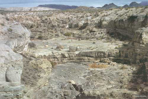
Once you're standing on the observation platform and looking upstream (to the right) (fig. 4), you can see a lip of rock about 10 feet high. On the rare occasions when water flows in Blue Creek, a wide waterfall runs down this rock face. Below it lies a broad surface of dark volcanic rock (if you want another view, it's the darker patch in the center of figure 2). That surface is the top of a once-buried lava flow that was uncovered when the soft overlying rock was worn away by erosion. This basalt lava resists weathering and erosion because it does not break into small particles as easily as does the overlying pyroclastic rock (the light-colored layers). Pyroclastic (literally "fire-broken") products of explosive volcanic eruptions are generally called "volcanic ash," but, scientifically speaking, ash simply means loose pyroclastic particles less than approximately 0.1 inch across. Tuff is rock made up mostly of hardened ash. So the name "Tuff Canyon" is not correct because the deposits here are made up mostly of particles much larger than 0.1 inch. The pyroclastic particles in this canyon, furthermore, do not stick tightly together, as they must in tuff. It's probably a little late in the game to change Tuff Canyon's name, and I doubt that the scientifically correct "Pumice Lapilli Canyon" would catch on.
As you stand here on the east observation platform, you can't help but wonder how this vista came to be. Perhaps a story can help. Once upon a time, before a volcano began to erupt the pyroclastic particles you see, an earlier eruption from a different volcano had covered this part of the park in basalt lava, which formed a fairly smooth and hard surface. How do we know? Look at any pile of layers that have formed on the Earth's surface. The top layer is younger than the one below it. In fact, ANY layer is younger than the one below it and older than the one above it. This rule holds true unless the entire pile of layers has been turned over. The only place in the park where overturned rock layers can be seen is on the mountainside just east of the Persimmon Gap ranger station at the northern park entrance.
|
| Figure 4. View of upper part of Tuff Canyon from the east observation platform, showing dry waterfall in center and dark lava surface under lighter colored pyroclastic deposits. |
In Tuff Canyon the dark lava (named the Bee Mountain Basalt) is about 34 million years old. Scientists calculated this age by measuring the proportions of a radioactive isotope of potassium and its decay product, argon. The smaller the ratio of potassium to argon, the older the rock, because there has been more time for more potassium to decay into argon.
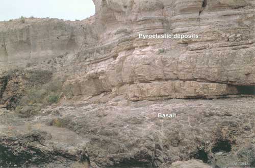
Using the layering rule then, we know that the pyroclastic deposits lying on the Bee Mountain Basalt (fig. 5) must be younger than 34 million years old. But how much younger? An answer can be found in another canyon about 1,600 feet east-southeast of Tuff Canyon. There, these same pyroclastic layers are overlain by lava called the Burro Mesa Rhyolite, which has been calculated by the potassium-argon method to be 29 million years old. This lava, having the same makeup as the pyroclastic material, is thought to be the result of the same volcanic eruption. The pyroclastic rocks in Tuff Canyon are therefore thought to be 29 million years old!
|
| Figure 5. Pyroclastic deposits overlying basalt, below east observation platform, Tuff Canyon. The lighter colored pyroclastic deposits form the cliff, which is about 20 feet high. |
The landscape today does not look the same as it did at the time of the eruption; 29 million years is enough time for high-standing areas to erode, low places to fill by deposition of sediment, and displacement by faults to occur. Those features that are high today owe their height to combinations of hard, resistant rocks and uplift along faults, and not to the piling up of volcanic rocks by eruptions. Some faults may still be active, but earthquakes in West Texas are rare events. In modern times, the only damaging quakes to have occurred happened about 115 miles northwest of Tuff Canyon in 1931 and about 100 miles north-northwest in 1995.
Well, time to mosey. You've seen enough at this platform, but there's more! Retrace your steps to the parking area. From the west end of the parking area, walk north on the trail along the west rim of the side valley to the central observation platform (#2 on the map at the back of the book). It's another 5-minute walk.
| <<< Previous | <<< Contents >>> | Next >>> |
state/tx/2000-DE02/sec4.htm
Last Updated: 03-Aug-2009