
|
Texas Bureau of Economic Geology
Down to Earth at Tuff Canyon, Big Bend National Park, Texas |
VIEW FROM THE PARKING AREA
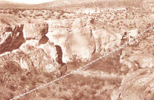
You get to the Tuff Canyon parking area by taking Ross Maxwell Scenic Drive; the parking area on the north side of the road is well marked, and is about 2 miles north of Castolon and 9 miles south of the turn for the Burro Mesa Pouroff (fig. 1). As you look northwest from the parking area, you see Tuff Canyon running parallel to the road and side valleys pointing toward you and away from you (fig. 3). Where the side valleys intersect Tuff Canyon, it is wider. Rapid weathering and erosion along a fault have loosened and removed more material to widen the canyon here. The fault is buried in the floor of the side canyon farthest from you, and it runs along the base of the left (southwest) wall of the side canyon just below the parking area. The rocks on the east (upstream) side of the fault have dropped farther down than those on the west side. Because the rock exposed on the west side of the fault is more resistant to weathering and erosion than the rock on the east side, the west banks of the side canyons form higher and steeper cliffs than those on the east banks. A short trail leads from the parking area down into the southern side canyon, but because this trail ends in a steep scramble to the canyon floor, it is not recommended. Instead, let's take the easternmost trail, up the gentle slope from the parking area, to the east observation plat form (#1 on the map at the back of the book). It's about a 5-minute walk.
|
| Figure 3. View from Tuff Canyon parking area to the north-northwest, looking at the cross-canyon fault. The high-standing area on the left (west) is more resistant rock that has moved up higher than the rock on the right, along a fault (dashed line). The fault runs parallel to the cliffs. |
| <<< Previous | <<< Contents >>> | Next >>> |
state/tx/2000-DE02/sec3.htm
Last Updated: 03-Aug-2009