|
California Division of Mines and Geology
Special Report 106 Geologic Features—Death Valley, California |
TABLE OF CONTENTS
High-altitude oblique aerial photograph oriented west-southwestward across north-central Death Valley. The crest of part of the Panamint Range lies beneath the string of clouds just beyond central Death Valley. Tucki Mountain is directly under small cloud near center of photograph. Small dark patch on right edge of symmetrical alluvial fan barely left of center of photograph is Furnace Creek Ranch. Mass of clouds at upper right are near Mt. Whitney in the Sierra Nevada. Funeral Range occupies foreground. Photo U.S. Air Force 018R 191, 10 July 1968; courtesy of the U.S. Geological Survey.
Precambrian Sedimentary Environments of the Death Valley Region, Eastern California, by L. A. Wright, B. W. Troxel, E. G. Williams, M. T. Roberts, P. E. Diehl
Geologic Map of the Region of Central and Southern Death Valley, Eastern California and Southwestern Nevada, by Lauren A. Wright
Fault Map of the Region of Central and Southern Death Valley, Eastern California and Western Nevada, by Lauren A. Wright
Geology of the Grapevine Mountains, Death Valley, California: A Summary, by Mitchell W. Reynolds
Geologic Features of the Central Black Mountains, Death Valley, California, by James K. Otton
Stratigraphy and Depositional Environments of the Crystal Spring Formation, Southern Death Valley Region, California, by Michael T. Roberts
The Noonday Dolomite and Equivalent Stratigraphic Units, Southern Death Valley Region, California, by Eugene G. Williams, Lauren A. Wright, Bennie W. Troxel
Stratigraphic Cross Section of Proterozoic Noonday Dolomite, War Eagle Mine Area, Southern Nopah Range, Eastern California, by L.A. Wright, E.G. Williams, Preston Cloud
Stratigraphy and Sedimentology of the Wood Canyon Formation, Death Valley Area, California, by Paul Diehl
Geologic Maps and Sections of a Strip from Pyramid Peak to the Southeast End of the Funeral Mountains, Ryan Quadrangle, California, by James F. McAllister
Geology of the Shoshone Volcanics, Death Valley Region, Eastern California, by Richard Haefner
|
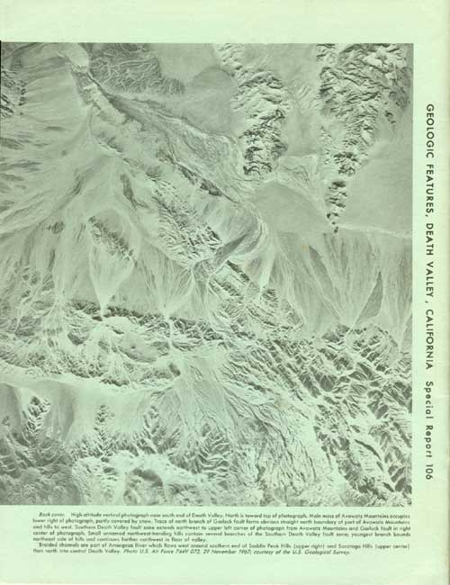
| High-altitude vertical photograph near south end of Death Valley. North is toward top of photograph. Main mass of Avawatz Mountains occupies lower right of photograph, partly covered by snow. Trace of north branch of Garlock fault forms obvious straight north boundary of part of Avawatz Mountains and hills to west. Southern Death Valley fault zone extends northwest to upper left corner of photograph from Avawatz Mountains and Garlock fault in right center of photograph. Small unnamed northwest-trending hills contain several branches of the Southern Death Valley fault zone; youngest branch bounds northeast side of hills and continues farther northwest in floor of valley. Braided channels are part of Amargosa River which flows west around southern end of Saddle Peak Hills (upper right) and Saratoga Hills (upper center) then north in central Death Valley. Photo U.S. Air Force 744V 073, 29 November 1967; courtesy of the U.S. Geological Survey. |
|
STATE OF CALIFORNIA DEPARTMENT OF CONSERVATION |
THE RESOURCES AGENCY DIVISION OF MINES AND GEOLOGY |
| <<< Previous | <<< Contents >>> | Next >>> |
state/ca/cdmg-sr-106/contents.htm
Last Updated: 24-Jul-2009