
|
Geological Survey Professional Paper 554—D
Cenozoic Volcanic Rocks of the Devils Postpile Quadrangle, Eastern Sierra Nevada California |
ANDESITE OF DEADMAN PASS
The oldest known Cenozoic volcanic unit exposed in the quadrangle consists of andesite and basalt flows of late Pliocene age. They are well exposed on the flanks of the ridge that extends northwestward from Minaret Summit to the north edge of the quadrangle. The flows are exceptionally well exposed in the vicinity of Deadman Pass, and this locality is informally used to designate the unit. Although the unit here has generally been considered to be of Miocene (Erwin, 1934) or early Pliocene age (Gilbert, 1941), Axelrod and Ting (1960) postulated a late Pliocene age from a spore-pollen flora in underlying and intercalated sediments in the basal part of the section. A late Pliocene age is supported by a potassium-argon age determination of 3.1 ± 0.1 million years for a sample obtained just north of Minaret Summit (Dalrymple, 1964a, table 1).
The single chemically analyzed Sample from this unit is an olivine trachyandesite (table 3). Data from additional fused samples (fig. 5), however, indicate a wide range in composition, with an average silica content of approximately 51 percent, occurring principally at the basalt-andesite boundary used in this report. In two earlier reports (Huber and Rinehart, 1965a, b) based upon data then available, this map unit was classified as andesite. This designation is retained here, although basalt is more abundant than previously suspected and is the dominant rock type locally, as in the Agnew Pass area.
In the Deadman Pass area the andesite occurs as a series of nearly horizontal flows and intercalated andesitic cinders and rubble. The flows range in thickness from a few feet to 25 feet, and most intervening rubble zones are less than 5 feet thick. Exposures south and northwest of Deadman Pass indicate that locally the unit had an original thickness of at least 1,600 feet; the imposing cliffs indicate that the flows also must have once extended over a much larger area than they now occupy. The andesite flows originally probably covered much of the area of the present valley of the Middle Fork of the San Joaquin River south and west of Deadman Pass and extended at least 3 miles eastward in the northeast corner of the quadrangle into the Mammoth Embayment, a large reentrant in the eastern front of the Sierra Nevada (Mayo, 1934, p. 79; Rinehart and Ross, 1964, p. 52). In fact, inasmuch as the San Joaquin Mountain ridge has been uplifted relative to the Mammoth Embayment, an appreciable thickness of the andesite of Deadman Pass may lie concealed beneath the extensive pumice cover of the Embayment. Small exposures of andesite of uncertain age occur at scattered localities in the Mammoth Embayment.
In the south half of the quadrangle, erosional flow remnants, similar in composition and age to the andesite of Deadman Pass, are preserved on benches above the Middle and North Forks of the San Joaquin River and in several places extend part way down into the canyons. Potassium-argon ages of 3.3±0.1 million years for a remnant south of Snake Meadow and 3.5±0.1 million years for a remnant east of Pine Flat have been obtained (Dalrymple, 1964a, table 1).
Andesites exposed in erosional remnants on Mammoth Crest are similar to the andesite of Deadman Pass and are tentatively correlated with it. Support for this correlation is lent by a remnant of andesite in a similar physiographic position on the ridge above the old Mammoth Mine in the Mount Morrison quadrangle 2 miles east of Mammoth Crest. This andesite has been dated by the potassium-argon method at 3.1±0.1 million years (Dalrymple, 1964a, table 1).
The scattered erosional remnants in the southwestern part of the quadrangle rest in places upon an erosion surface which Matthes (1960, p. 41-44) correlated with his "Broad Valley stage" of erosion that he considered to be of late Miocene age. The Broad Valley surface had not only been established prior to the eruption of the late Pliocene andesitic rocks, but had also been dissected to a depth of approximately 2,000 feet in the Middle Fork canyon, as indicated by andesitic remnants within the canyon. This dissection probably represents erosion during Matthes' (1960, p. 40) "Mountain Valley stage," which Matthes considered to be of Pliocene age, perhaps continuing into the early part of his subsequent "Canyon stage" (Dalrymple, 1964a, p. 28). Whatever the absolute age of the Broad Valley and Mountain Valley erosion stages, it is clear that both antedate late Pliocene and cannot be of Pleistocene age as postulated by Hudson (1960, p. 1556) and Axelrod (1962, p. 185-186).
The relationship of the andesite near Deadman Pass to the Broad Valley surface is critical to the interpretation of the local geomorphic history, inasmuch as we correlate andesites which rest upon the already partly dissected Broad Valley surface in the southern and western parts of the quadrangle with those near Deadman Pass. Matthes (1930, 1960) concluded that during the late Tertiary a major fork (perhaps the main channel) of the San Joaquin River probably had its source east of the present drainage divide and was beheaded by the formation of the fault escarpment on the east side of that ridge. Erwin (1934) apparently accepted the concept of a throughgoing drainage at this locality and suggested that the lavas exposed on the San Joaquin Mountain ridge may have in places flowed down this ancient drainage and were later uplifted along the fault-bounded range front. If this drainage reconstruction is true, and we consider it a reasonable interpretation, then the Broad Valley surface, with an inner channel perhaps representing the Mountain Valley stage, presumably extended eastward from the present Middle Fork valley beneath the andesite of Deadman Pass. A possible location for such an old channel is just south of Deadman Pass, where the base of the andesite is at its lowest elevation.
Axelrod and Ting (1960, p. 8, 25) also considered the Broad Valley surface to extend from the Middle Fork basin eastward beneath the andesite near Deadman Pass, although Axelrod (1962, p. 186) later revised his views and stated that the andesite near Deadman Pass "lies on the older Boreal surface which has been downdropped on a north-trending fault that traverses the west side of San Joaquin Mountain to give the illusion that it is on the Broad Valley surface which is well exposed across the valley." We were unable to find any evidence in the field for such a fault and therefore support the view that the Broad Valley surface, probably modified by Mountain Valley stage erosion, continues eastward beneath the andesite near Deadman Pass.
We do not intend to imply that all the andesites and basalts in this map unit were necessarily part of a single sheet of uniform age. Rather, the evidence merely suggests that slightly over 3 million years ago widespread andesitic flows were deposited over extensive areas. As mentioned previously, Erwin (1934, p. 47, 58) suggested that the source of the andesites was east of the present drainage divide (San Joaquin Mountain ridge), and that the andesites flowed southwestward and southward down an ancient fork of the San Joaquin River. Gilbert, (1941, p. 793) also considered the andesites and basalts in this part of the Sierra crestal area to be similar to rocks exposed over extensive areas north and east of Long Valley, 10 miles and more east of Deadman Pass. Although an eastern source for much of the andesite appears reasonable, there is evidence for local sources in various parts of the Devils Postpile quadrangle. For example, two andesitic necks, planed by glaciation and presumably of Pliocene age, were noted near Emerald and Cabin Lakes in the metamorphic belt west of Middle Fork. In addition, the joint pattern and rock textures of some of the andesitic outcrops north of Agnew Pass and south of Iron Creek suggest scattered local volcanic sources. Differences in average composition of andesitic outliers also are compatible with scattered local sources.
QUARTZ LATITE OF TWO TEATS
Quartz latite caps the andesite of Deadman Pass over much of the ridge that extends northwestward from Minaret Summit and is especially well exposed on the double prominence of Two Teats, where its thickness is more than 1,000 feet. Additional erosional remnants east of Two Teats, such as ridges north and south of Glass Creek Meadow, attest to a much greater original extent. This unit is the "Miocene andesite" of Erwin (1934, p. 47-48), but its age has been determined as late Pliocene by the potassium-argon method (3.0±0.1 million years, Dalrymple, 1964a, table 1). The rock is extremely varied in both color and texture, but it is generally porphyritic with phenocrysts of plagioclase, hornblende, and biotite in a microcrystalline groundmass. Flow structures are common. Classification of this rock as quartz latite is based on chemical analysis (table 3) and, fused-bead data (fig. 5).
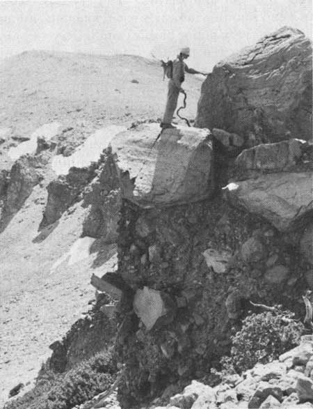
The base of the quartz latite of Two Teats is nearly everywhere concealed by slope wash and pumice. Although in most places it appears to be underlain by andesite of Deadman Pass, the quartz latite rests unconformably upon metasedimentary rocks about 1 mile southeast of Two Teats. There the lowermost rock of the unit is pyroclastic and contains numerous fragments of the underlying metasedimentary and granitic rocks, as well as the andesite. On the east slope of San Joaquin Mountain, the basal part of the unit is a coarse breccia that consists of fragments of quartz latite, ranging in size from cobbles to blocks more than 15 feet across that are enclosed in a tuffaceous matrix (fig. 6). The breccia is rudely stratified and dips about 20° to the west (into San Joaquin Mountain). The coarse breccia blocks suggest an explosive initial phase from an apparently nearby vent. Further indications of a neighboring source are: (1) a narrow hypabyssal dike that cuts pre-Tertiary granitic rocks a mile northeast of Glass Creek Meadow is, except for a holocrystalline groundmass, petrographically similar to the quartz latite and may be a feeder and (2) a small intrusive body, petrographically identical with the quartz latite, that cuts the andesite of Deadman Pass about a mile southeast of Deadman Pass and may also be a feeder.
|
| FIGURE 6.—Basal part of quartz latite of Two Teats on east side of San Joaquin Mountain showing blocks of quartz latite in a tuffaceous matrix. |
Examination of the map shows that the surface on which the quartz latite was deposited had considerable local relief; for example, the surface varies as much as 1,500 feet in elevation within half a mile, southeast of Two Teats. The westward inclination of the breccia beds may reflect initial slope from an eastern source or perhaps only the slope of underlying topography.
ANDESITE FROM DEADMAN-GLASS CREEKS AREA
Andesite underlies a small area in the extreme northeast corner of the quadrangle and is nearly contiguous with with a large mass that extends for several miles northeast of the quadrangle, where it forms part of the northern escarpment of the Long Valley basin. The typical rock is medium gray and locally somewhat vesicular and contains abundant brownish-olive equant crystals of olivine and clinopyroxene. Scattered tiny pyrite crystals are fairly common. Fused samples of several specimens indicate a fairly wide range in the percentage of silica but suggest that the average chemical composition is andesitic.
Because exposures of this andesite in both the Devils Postpile and the Mount Morrison quadrangles occupy less than half a square mile, the rock was not studied in sufficient detail to determine its relation to the local volcanic sequence. Near Crestview, a little more than a mile northeast of the quadrangle, similar andesite is overlain by the Bishop Tuff, a relation indicating an age no younger than middle Pleistocene. Furthermore, the position of the andesite exposed in the escarpment of the Long Valley basin—an eroded fault scarp possibly as old as late Tertiary—suggests that the andesite may be as old as Tertiary and is shown as Tertiary by Gilbert (1941, p. 785 and 787, figs. 2 and 3).
| <<< Previous | <<< Contents >>> | Next >>> |
pp/554-D/sec2.htm
Last Updated: 18-Jan-2007