
|
Geological Survey Professional Paper 1547
Sedimentology, Behavior, and Hazards of Debris Flows at Mount Rainier Washington |
INTRODUCTION
Mount Rainier volcano is potentially the most dangerous of the periodically active volcanoes of the Cascade Range, which extends from northern California into British Columbia. The mountain is second only to Mount St. Helens in seismic activity, and it is the highest volcano in the Cascade Range. It also has the largest mass at high altitude, above 3,000 m for example, and consequently has a perennial snow and glacier mantle that is approximately equal in volume to that at all other Cascade Range volcanoes combined (Driedger and Kennard, 1986).
|
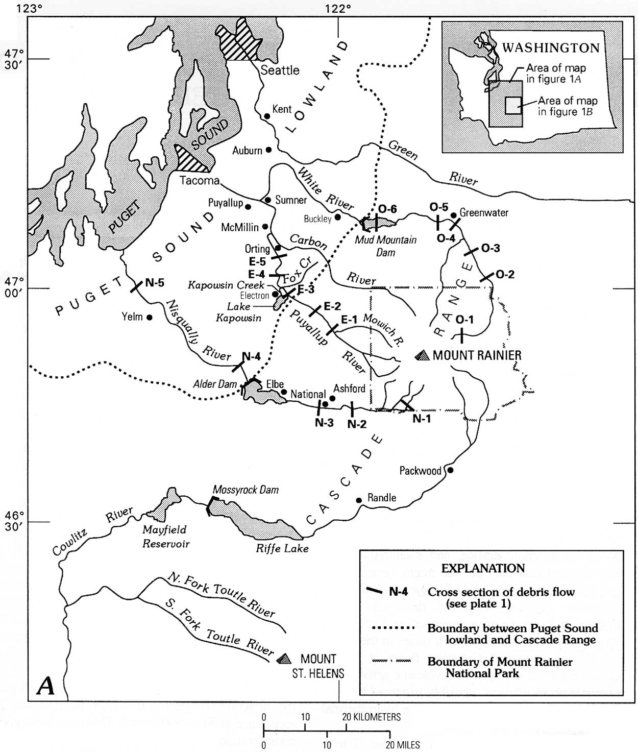
| Figure 1a. Location of Mount Rainier, localities of lahar cross sections, and other features of interest in southwestern Washington. All cross sections are shown on plate 1. Cross-section localities for Tahoma Lahar (T) are shown on detailed map B (below); all other cross-section localities are shown above. A, Major streams, dams, reservoirs, and population centers in the region. (click on image for an enlargement in a new window) |
|
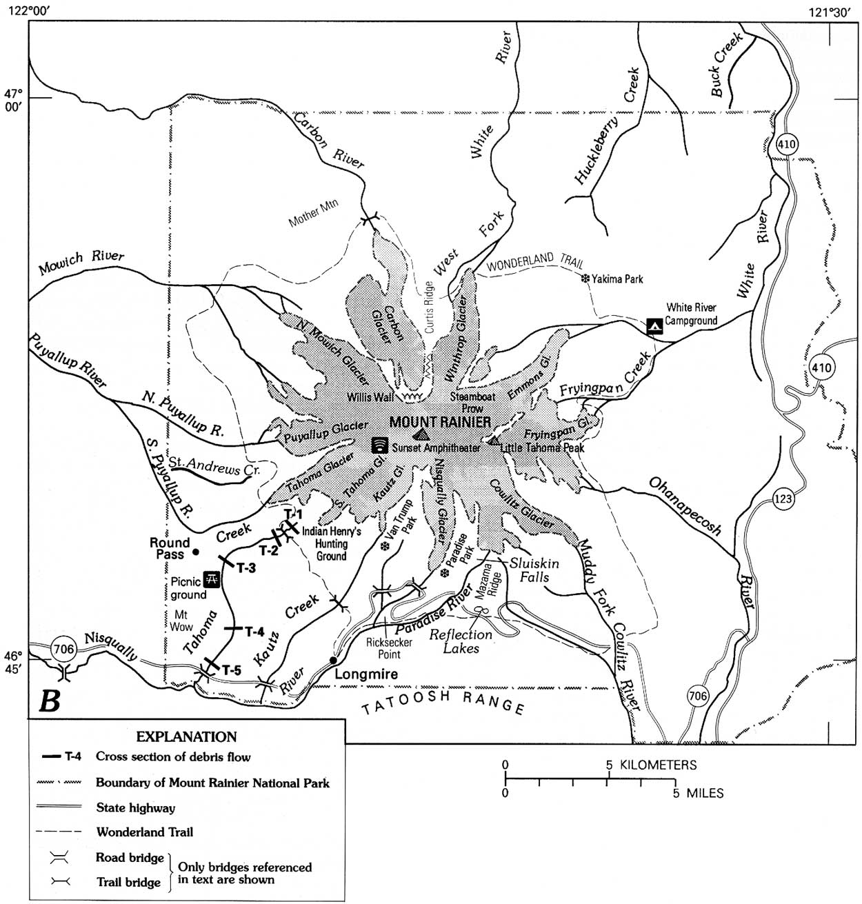
| Figure 1b. B, Enlarged map of Mount Rainier National Park showing glaciers, streams, and major roads and trails. |
The volcano is the dominant feature of Mount Rainier National Park, located about 70 km southeast of Seattle, Wash. It is drained by five major river systems (fig. 1): the White River on the northeast, the Cowlitz River on the southeast, the Nisqually River on the southwest, and the Puyallup and Carbon River systems on the northwest. All but the Cowlitz River traverse at least 100 km of both the Cascade Range and the Puget Sound lowland before emptying into Puget Sound. The Cowlitz flows more than 140 km southward and enters the Columbia River. For more than 45 km upstream of Riffe Lake, the Cowlitz's flood plain is unusually wide, averaging about 2 km in width.
Mount Rainier volcano has an extensive history of post glacial debris flows that originated from collapse of major sectors of the mountain (Crandell, 1971). Many recent studies of similar composite volcanoes show that evolution by periodic sector collapses is a common morphologic progression. Risk analysis in this report shows that the debris flows of this origin pose the greatest hazard at Mount Rainier. These flows are distinguished here as cohesive debris flows to indicate the importance of their "sticky," relatively clay-rich matrix in determining flow behavior, and their defining characteristic is their ability to remain unchanged as debris flows to their distal ends. Evidence of the flows is traced downstream, and flow dynamics are defined where the flows left the canyons of the Cascade Range to inundate flood plains, now increasingly populated, on the Puget Sound lowland (fig. 1).
A second type of debris flow, which is common at Mount Rainier, is substantially different in origin and behavior and yields deposits distinctly more granular in texture. These relatively clay-poor flows, distinguished here as noncohesive to indicate the importance of grain-to-grain contact in determining behavior, readily transform both from and to other flow types. Noncohesive debris flows originate most commonly as water surges produced by melting of snow by volcanic heat. Although less of a general hazard than the debris flows that originate as large slope failures, noncohesive flows occur more often, and their runout phases could inundate parts of the Puget Sound lowland. Because of their shorter recurrence intervals, noncohesive flows pose a more likely threat to life and property locally on and near the base of the volcano. The recognition of the deposits of this flow type and its transformations has significant implications for the reconstruction of a volcano's history. As illustrated by the forecast of Crandell and Mullineaux (1978) at Mount St. Helens, 80 km south of Mount Rainier, a volcano's history is the best guide to its future behavior.
Some noncohesive debris flows reflect another factor contributing to the exceptional flow hazards at Mount Rainier: its mantle of ice and snow is subject to volcanically induced melting. A geothermally formed subglacial lake has existed in at least one of the two summit craters (Lokey and others, 1972; Kiver and Steele, 1972), and it may still exist but its presence hasn't been verified since 1978 (W. M. Lokey, Pierce County Dept. of Emergency Management; written commun., 1989). A subset of noncohesive flows consists of debris flows formed from glacial-outburst floods. Although these flows have been a hazard only locally, they provided important behavioral models of noncohesive flows from 1986 to 1992.
The purpose of this report is to define the origins, magnitude, and frequency of debris flows and other flow types associated with debris flows, with particular reference to volcanic hazards. The probability of such flows is similar in most of the drainage basins, as indicated by the present-day symmetry of hydrothermal activity, occasional small earthquake clusters centered beneath the summit, and our inability to forecast which sector of the volcano will be affected by renewed volcanic, seismic, or geothermal activity. However, several factors affect variations in probabilities between drainages. For example, sector collapses that produce huge, cohesive debris flows can occur on any flank of Mount Rainier, but northward- or northeastward-directed failure may be especially likely because the summit cone is formed in an amphitheater resembling a "greased bowl" that is probably open to the north (Frank, 1985, p. 180).
In analyzing flows of sediment and water in populated valleys surrounding the volcano, this study complements ongoing studies by the U.S. Geological Survey of Mount Rainier's volcanic hazards and glacially related hydrologic hazards. There is necessarily some overlap in these investigations because many large debris flows were volcanically initiated, and many small debris flows originated as glacial-outburst floods. As at Mount St. Helens, however, there is a record of more large debris flows than the number of known volcanic events, and glaciers do not exert a primary influence in forming the larger flows. This report, therefore, concentrates on the actual down stream stratigraphic record of flows and their dynamics, as revealed by sedimentologic and paleohydrologic evidence, rather than evidence from volcanic or glacial activity.
ACKNOWLEDGMENTS
Although this study mainly focused on the flow record beyond the base of the volcano, some work within Mount Rainier National Park was necessary, and the writers are indebted to the personnel of the National Park Service cited herein for their observations of flow phenomena and for information on the 20th-century flow record. W.V. Steuben and D.J. Gooding, U.S. Geological Survey, overcame the extensive problems in laboratory analysis of the cohesive deposits. The manuscript benefited substantially from review by J.C. Brice, J.E. Costa, and C.L. Driedger, all of the U.S. Geological Survey, and K.S. Rodolfo, University of Illinois at Chicago; and from review of specific topics by D.R Crandell, U.S. Geological Survey, R.R. Dibble, Victoria University of Wellington, and W.M. Lokey, Pierce County Department of Emergency Management.
| <<< Previous | <<< Contents >>> | Next >>> |
pp/1547/intro.htm
Last Updated: 01-Mar-2005