
|
Geological Survey Bulletin 613
Guidebook of the Western United States: Part C. The Santa Fe Route |
ITINERARY
MAIN LINE WEST OF WILLIAMS.
From Williams (see sheet 19, p. 122) westward for some distance Bill Williams Mountain is a prominent feature south of the railway. Cinder cones are in view to the north, and one of considerable size also lies at the foot of Bill Williams Mountain a short distance south of the tracks. After passing Supai siding, 3 miles west of Williams, the train begins the long descent from the high plateau of lava and Kaibab limestone. From Supai to Corva a new line with an easier grade has been built for the eastbound trains. The lava (basalt) extends to the edge of the plateau and for a considerable distance down its western slope, but the deeper canyons in the slope cut through into the Kaibab limestone.
|
|
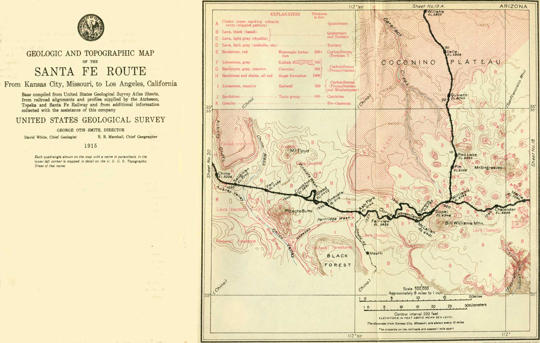
SHEET No. 19 (click on image for an enlargement in a new window) |
There are deep cuts in the basalt at the entrance to Johnson Canyon. This gorge affords an advantageous line of descent for the westbound trains and exhibits many features of interesting geology and attractive scenery
Halfway between mileposts 388 and 389 the Kaibab limestone appears under the lava, and the train passes through a tunnel in the limestone with the lava cap not far above. On leaving the tunnel it goes over a long trestle, below which are many cliffs of the limestone, most of them with a capping of lava. In the deep canyon to the south are some sink holes in the limestone, known as the Bottomless Pits, into which the water disappears when there has been sufficient rain to develop a stream in the canyon. They are similar in character and origin to the pits described on page 117.
A short distance beyond milepost 390 the lava descends over the limestone ledges to a level somewhat below that of the bottom of Johnson Canyon, and for several miles west from this place it constitutes a broad bench that extends for some distance north and south of the canyon. From these relations it appears that the outflow of lava, probably issuing from a vent on top of the plateau west of Williams, flowed westward over the plateau surface and down its western slope. The canyons have been eroded by streams since the time of this eruption, and some of the deeper ones have been cut through the lava into the underlying limestone. In part of the slope a few miles south of Johnson Canyon the grade down which the lava flowed was very steep, and at this place the igneous rock is very much broken where it cascaded over the limestone ledges. This outflow occurred many thousand years ago, as much erosion has taken place since; but compared with most of the other events in geologic history it was very recent.
|
Fairview. Elevation 5,935 feet. Kansas City 1,315 miles. |
The broad bench made by the lava at the lower level just mentioned is well exhibited near Corva, where the eastbound track joins the old line. Fairview is a siding on this bench. A short distance beyond Fairview is a cut in a low cinder cone that shows that there was a volcanic vent at this place from which may have issued some of the lava on the lower bench. Two miles farther west is a long cut in cinders, including numerous bombs of various sizes.
About 4 miles west of Fairview there are excellent views of the edge of the high plateau extending off northwestward. The white ledges of Kaibab limestone appear in places, capped by the black lava at the summit of the plateau and underlain by the Coconino sandstone extending down some distance to the lava-covered bench above mentioned. The extension of the cliff to the southeast is also visible but less plainly.
At milepost 399, 5 miles west of Fairview, there are long cuts in cinders with bombs, beyond which the railway descends westward in long sweeping curves that extend nearly to Ash Fork. At the foot of this down grade there is a wide valley trending northwest and occupied largely by lava which has flowed from many local orifices, in most places marked by cinder cones. A section showing the general relations in the descent of the great escarpment east of Ash Fork is given in figure 31.
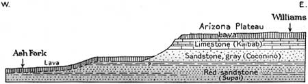
|
| FIGURE 31.—Section of the west slope of the Arizona Plateau between Williams and Ash Fork, Ariz., looking north. |
This descent is the first in a series of great westward-facing steps formed by the thick pile of sedimentary rocks constituting the plateau region of western Arizona. These rocks are shown in cross section in the Grand Canyon, and in the westbound journey the traveler sees, beyond Williams, the same succession that is revealed in the descent into the canyon from the rim. The first step is the western edge of the Kaibab limestone which caps the plateau and finally terminates in the Aubrey Cliffs. The second great step consists of the Grand Wash escarpment, Music Mountain, and the cliffs south of Peach Springs, in which the western edges of the lower part of the Redwall limestone and the underlying shales and sandstones are presented at the termination of the plateau province.
|
Ash Fork. Elevation 5,144 feet. Population 517.* Kansas City 1,322 miles. |
Ash Fork owes its existence mainly to the fact that it is the junction of the branch railway to Prescott, 57 miles south, and Phoenix, 194 miles south. Many of the trains stop here for meals at the Escalante, a hotel named in memory of Francisco S. Vélez Escalante, a Spanish missionary who traveled though this country in 1775. Ash Fork has an exceptionally good climate and is ambitious to become a winter resort.
A mile west of Ash Fork, in a low cinder cone just south of the railway, there is a large pit from which material is excavated for ballast. The exposed face, 50 feet high, exhibits the relations of the cinders with many included bombs and more or less admixture of volcanic ash. For some distance westward the train passes over a plain of lava which floors the wide valley in which Ash Fork is situated. To the west rises the prominent peak known as Picacho (pee-cah'tcho) Butte, and to the northwest Mount Floyd, both large masses of the older igneous rock similar to that in the San Francisco Mountains and Bill Williams Mountain.
A mile or more beyond Pineveta the eastbound tracks diverge to the north, crossing over the old line, which is reserved for westbound traffic and which climbs out of this valley up the steep grade to the west by numerous large curves, including one notable loop known as Horseshoe Bend. On these loops there are excellent views to the east, in which Bill Williams Mountain is a prominent feature, rising far above the relatively even sky line at the crest of the high plateau. Farther east on the horizon the peaks of the San Francisco Mountains are conspicuous, though somewhat dwarfed by distance. The slope on which the track rises consists of lava (basalt) and toward its higher portion there are many junipers.
|
Crookton. Elevation 5,691 feet. Kansas City 1,339 miles. |
Near Crookton, one-tenth of a mile west of milepost 419, where the summit of this grade is reached, the two tracks come together again, with that for the westbound traffic on the right-hand side. The summit consists of lava (basalt) and this rock extends along both sides of this divide and down the west slope. Picacho Butte is a prominent feature to the south and Mount Floyd and the surrounding peaks rise about 8 miles to the north.
From Crookton to Seligman there is a long descent of 450 feet on lava-covered slopes into the valley of Chino (chee'no) Wash. The lava lies on the sloping surface of the limestone which caps the Aubrey Cliffs to the north. The interruption in these cliffs in this portion of their course was a fortunate thing for the construction of the railway. If they had extended continuously across the country at a height of 1,200 feet, as to the north and south, there would have been great difficulty in building the railway down them. The break in their continuity was developed by erosion or faulting prior to the time of the volcanic eruptions, and now the sloping surface is covered by the extensive sheet of lava extending from Crookton to Seligman and beyond.
|
Seligman. Elevation 5,242 feet. Population 338.* Kansas City 1,350 miles. |
Seligman, being a railway division point, is sustained largely by the railway interests, together with trade from scattered ranches in some of the adjoining valleys. The railway time changes here from mountain to Pacific time, one hour earlier. Formerly the branch line to Phoenix joined the main line at this place, following a relatively easy grade up Chino Valley. It was changed to shorten the distance from Phoenix to the East. There is a road from Seligman north 67 miles to Cataract Canyon, a branch of Grand Canyon, which has high red walls and several picturesque waterfalls. Here live the Havasu (Supai) Indians, who cultivate a few acres of rich land by the water from the great springs that form Cataract Creek.
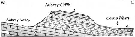
Railway cuts a short distance west of Seligman show the red sandstone and shale of the Supai formation lying on Redwall limestone. Three miles west of Seligman, near Chino, high cliffs of red sandstone (Supai formation) are conspicuous along the northeast side of the railway. They extend along the lower slope of the Aubrey Cliffs, which continue as a long, high wall far to the north. Above the red sandstones in these cliffs are ledges of light-gray sandstone (Coconino), which is softer and less conspicuous here than in the walls of the Grand Canyon. At the top of the cliff are light-colored ledges of the cherty Kaibab limestone, forming a plateau that slopes somewhat to the east. The relations in this cliff are shown in figure 32.
|
| FIGURE 32.—Section through Aubrey Cliffs, northwest of Seligman, Ariz., looking north. a, Limestone (Redwall); b, red sandstone and shale (Supai); c, gray sandstone (Coconino); d, limestone (Kaibab); e, lava. |
| <<< Previous | <<< Contents >>> | Next >>> |
bul/613/sec19b.htm
Last Updated: 28-Nov-2006