
|
Geological Survey Bulletin 1393
The Geologic Story of Arches National Park |
A TRIP THROUGH THE PARK
(continued)
Salt Valley and Klondike Bluffs
Before proceeding to the end of the paved road, let us take an unimproved side road, which turns south about a third of a mile beyond the last stop, in order to see more of Salt Valley and to visit Klondike Bluffs in the north western part of the park. After descending 2.3 miles of winding road we reach the normally dry bed of Salt Valley Wash, and turn abruptly to the northwest. For the next three-fourths of a mile the "road" is simply two tracks in the loose, sandy bed of the wash, which obviously should not be travelled when flooded or when there is even a hint of rain. In dry weather, however, this road may be travelled by ordinary passenger car. This stretch of the wash cuts through an intruded block of the Paradox Member of the Hermosa Formation consisting mainly of gray and brown gypsum, the common salt having been dissolved out by ground water. Such an intrusive block of salt-bearing rock is known to geologists as a diapir—not to be confused with the garment (diaper) worn by infants.
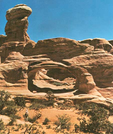
From here on the road traverses a rather uninteresting stretch of valley north of Salt Valley Wash. Eleven miles from the starting point, the road reaches an intersection from which a side road leads southwestward three-fourths of a mile to a parking area at the foot of Klondike Bluffs, which form the south side of Salt Valley. From here, one may make a strenuous hike over a primitive trail about 1-1/2 miles long to beautiful Tower Arch (fig. 47).
|
| A TOWER ARCH, on Klondike Bluffs, viewed eastward. Arch is in Slick Rock Member but tower on left, after which arch was named, is capped by a protective layer of the resistant Moab Member. Opening is 88 feet wide and 43 feet high. Photograph by Robert D. Miller. (Fig. 47) |
The valley road continues northwestward from the intersection to and beyond the northwest end of the park and connects with roads to Crescent Junction, Thompson, and the Yellow Cat mining district, north of the park (p. 14).
Let us return to the paved road and continue our tour of the park.
| <<< Previous | <<< Contents >>> | Next >>> |
bul/1393/sec10f.htm
Last Updated: 8-Jan-2007