
|
Geological Survey Bulletin 1386
Silurian, Devonian, and Mississippian Formations of the Funeral Mountains in the Ryan Quadrangle, Death Valley Region, California |
INTRODUCTION
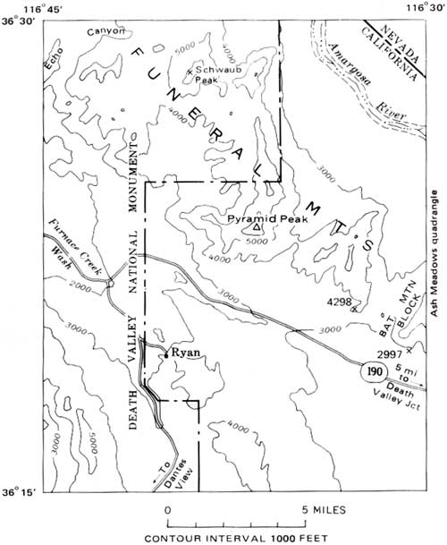
A complexly faulted stratigraphic sequence of Precambrian to Mississippian marine sedimentary rocks is exposed for a distance of 18 miles in the Ryan quadrangle (fig. 1), in the southeastern part of the Funeral Mountains between Death Valley and Amargosa Valley in Inyo County, Calif. The whole exposed sequence is about 25,000 feet thick, of which the Paleozoic portion is about 16,500 feet, and the Silurian, Devonian, and Mississippian formations together are about 4,700 feet. The sequence, as mapped in the Ryan quadrangle (McAllister, 1971), is assigned entirely to formations that have been recognized in the surrounding region (table 1).
|
| FIGURE 1.—Index map of the Ryan quadrangle. Locality information in the text is intended for plotting on the published topographic map. |
TABLE 1—Precambrian and Paleozoic formations of the Funeral Mountains in the Ryan quadrangle
| System | Series | Formation or group | Thickness1 (feet) |
| Mississippian | Upper | Perdido Formation | 500 |
| Lower | Tin Mountain Limestone | 300 | |
| Devonian | Upper | Lost Burro Formation | 2,500 |
| Middle | |||
| Lower | Hidden Valley Dolomite | 1,400 | |
| Silurian | |||
| Ordovician | Upper | Ely Springs Dolomite | 500 |
| Middle | |||
| Eureka Quartzite | 400 | ||
| Pogonip Group | 2,200 | ||
| Lower | |||
| Cambrian | Upper | Nopah Formation | 1,700 |
| Bonanza King Formation | 3,600 | ||
| Middle | |||
| Carrara Formation | 1,600 | ||
| Lower | |||
| Zabriskie Quartzite | 800 | ||
| Wood Canyon Formation | 24,000 | ||
| Precambrian | |||
| Stirling Quartzite | 24,800 | ||
| Johnnie Formation | 1,000 | ||
2Stewart (1970)
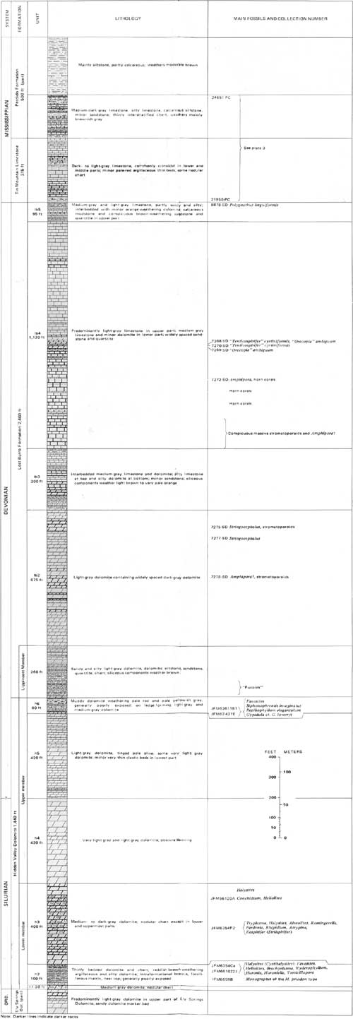
The Silurian through Mississippian sequence in the Ryan quadrangle consists of the Hidden Valley Dolomite of Silurian and Early Devonian age, the Lost Burro Formation of Middle and Late Devonian age, the Tin Mountain Limestone of Early Mississippian age, and the Perdido Formation of Early? and Late Mississippian age (pl. 1). A preliminary map shows the distribution of these formations in the quadrangle (McAllister, 1971). The type localities of the formations are in the Quartz Spring area or north of Ubehebe Peak (McAllister, 1952) between 50 and 65 miles west-northwest of the occurrences in the Funeral Mountains. Specialized studies of the formations at or near the type localities describe faunas and stratigraphy of the Tin Mountain and the Perdido (Langenheim and Tischler, 1960), occurrences of conodonts in uppermost Lost Burro (Youngquist and Heinrich, 1966) and the lower part of the Hidden Valley (Miller and Hanna, 1972), and petrology of the Lost Burro Formation (Zenger and Pearson, 1969).
|
| PLATE 1. COLUMNAR SECTION OF SILURIAN, DEVONIAN, AND MISSISSIPPIAN ROCKS IN THE RYAN QUADRANGLE, CALIFORNIA. (click on image for a PDF version) |
These formations are used in the Funeral Mountains on the east side of Death Valley, in the Panamint Range (McAllister, 1952, 1956; Hall and Stephens, 1962; Hunt and Mabey, 1966; Hall, 1971) and in the Last Chance Range (Burchfiel, 1969) on the west side of Death Valley, and as far west as the Argus Range and the Inyo Mountains (McAllister, 1956; Hall and MacKevett, 1962; Hall and Stevens, 1962, 1963; Merriam, 1963a; Hall, 1971). But east of the Funeral Mountains, in Nevada, formations within the equivalent stratigraphic sequence have different names and boundaries (Burchfiel, 1964; Tschanz and Pampeyan, 1970), as established in Nevada and Utah. Published diagrams show broad correlations of the Hidden Valley Dolomite (Ross, 1966, pl. 5; Berry and Boucot, 1970, pl. 2; Tschanz and Pampeyan, 1970, fig. 13), the Lost Burro Formation (Poole and others, 1967, fig. 2b; Tschanz and Pampeyan, 1970, fig. 13), and the Tin Mountain Limestone and the Perdido Formation (Langenheim and Tischler, 1960, fig. 5). Discussion of their regional correlation is deferred to a subsequent report.
The first published reference to the post-Ordovician part of the Paleozoic sequence in the Funeral Mountains apparently is the comment by Noble (1934, p. 177) that the section is nearly as complete as in the Nopah Range and contains abundant Mississippian fossils at the southeast end of the Funeral Mountains. The pre-Mississippian stratigraphy and some faunas are treated in theses by Richards (1957) and Kesse (1963). At the southeast tip of the Funeral Mountains, Silurian to Mississippian formations extend from the Ryan quadrangle into the margin of the Ash Meadows quadrangle where they were mapped and described by Denny and Drewes (1965, pl. 1, p. L9-L11).
Formations in the pre-Silurian part of the sequence in the Ryan quadrangle (table 1) are summarized—and some are described by stratigraphic sections—in reports by Yochelson, McAllister, and Reso (1965, fig. 4), Ross (1967, p. D32-D34), Stewart (1970, pl. 1, p. 91-97), and McAllister (1970, p. 2-3).
ACKNOWLEDGMENTS
The fieldwork, done mostly between 1960 and 1970, was part of a cooperative program of the U.S. Geological Survey and the California Division of Mines and Geology to learn more about the geologic setting of borate deposits in Tertiary rocks between Death Valley and Amargosa Valley. Donald W. Reeser ably assisted in the field during a brief period. On short field trips, Forrest G. Poole helpfully compared part of the stratigraphic sequence with his sections in southern Nevada, and I. Gregory Sohn collected Mississippian ostracodes. Professor William B. N. Berry of the University of California, Berkeley, and the following U.S. Geological Survey paleontologists, identified the fossils and commented on their stratigraphic significance: J. Thomas Dutro, Jr., Mackenzie Gordon, Jr., John W. Huddle, Charles W. Merriam, William A. Oliver, Jr., William J. Sando, Betty Skipp, I. Gregory Sohn, and Ellis L. Yochelson. It is a pleasure also to acknowledge the cordial cooperation of members of the National Park Service in Death Valley National Monument and their helpful concern about solitary work in the National Monument.
| <<< Previous | <<< Contents >>> | Next >>> |
bul/1386/intro.htm
Last Updated: 23-Jun-2009