
|
Geological Survey Bulletin 1292
The Geologic Story of Mount Rainier |
LANDSLIDES AND MUDFLOWS—PAST, PRESENT, AND FUTURE
Some of the most effective means of erosion at Mount Rainier are landslides and mudflows. Erosion of this kind is sometimes spectacular. Within an interval of only minutes or a few hours huge masses of rock may fall, slide, or flow off the volcano and move far downvalley.
Large landslides have occurred at many other places in the park—one in the area northwest of Mount Rainier is so conspicuous that its source has been named Slide Mountain. The ragged scar left by another slide near Grand Park is aptly called Scarface. You cross a slide on the Mather Memorial Parkway (U.S. Highway 410) just north of Cayuse Pass. Broken and jumbled rock debris of many sizes borders both sides of the highway there. This landslide broke loose in rocks of the Ohanapecosh Formation, slid downslope to the bottom of the valley, and dammed Klickitat Creek to form Ghost Lake. Rocks have also slid downslope on the west side of Backbone Ridge and on the east side of the Ohanapecosh River valley a short distance north of Ohanapecosh campground.The slide on Backbone Ridge is still slowly moving today. Another slide moves a few inches each year on the west side of the Nisqually River valley about l mile northwest of the visitor center at Paradise Park. You can recognize the slide by a jagged horizontal crack 1,000 feet long at its top.
A far more spectacular variety of landslide occurs when a mass of rock drops from a cliff to form a rockfall. The largest rockfalls on Mount Rainier in historic time occurred in December 1963 on the east flank. Masses of rock hundreds of feet across fell repeatedly from the steep north face of Little Tahoma Peak onto Emmons Glacier. The rock masses shattered into dust and countless fragments, fanned out across the glacier, then avalanched down the steep ice surface at tremendous speed. When the avalanches reached the end of the glacier they shot into space as sheets of rock debris. As these hurtling sheets settled toward the valley floor, a cushion of compressed air formed beneath them comparable to the air cushion that momentarily buoys up a sheet of plywood that is dropped onto a flat surface. Air that was trapped beneath these speeding avalanches reduced friction and permitted one of the avalanches to move almost 2 miles beyond the end of the glacier. This avalanche passed completely over a small wooden gauge house about 5 feet high on the valley floor without damaging it, then ran headlong into the north base of Goat Island Mountain where it scraped away trees and bushes. A later avalanche stopped just short of the gauge house, and wind that was expelled from beneath the rock debris blasted the still-undamaged house several hundred feet forward. It now rests in the scar left by the earlier avalanche on the side of Goat Island Mountain.
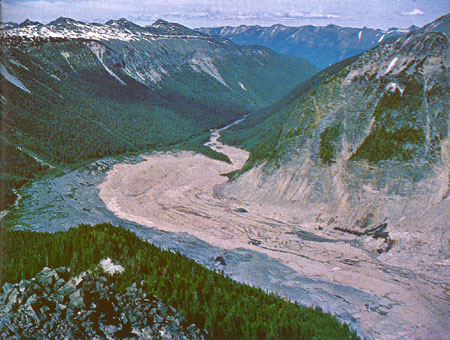
At least seven rockfalls and avalanches descended from Little Tahoma Peak, separated perhaps by only minutes or hours. The reddish-gray masses of broken and pulverized rock —some spread helter-skelter, some piled in long sharpcrested ridges — now lie on the valley floor between the White River campground and Emmons Glacier (fig. 19).
|
| AVALANCHE DEPOSITS in the White River valley. The rockfalls and avalanches from Little Tahoma Peak formed a mass of reddish-gray rock debris that contrasts with the darker gray glacial debris deposited by Emmons Glacier within the last century. The avalanche deposits are about 1,500 feet across at their widest point. (Fig. 19) |
The rockfalls might have been caused by a steam explosion near the base of Little Tahoma Peak. Steam jets and small explosions are not unusual phenomena at Mount Rainier, although they never have had such dramatic effects in historic time.
Incredibly larger avalanches of rock fell repeatedly from the sides of Mount Rainier during prehistoric time. One such avalanche originated near the summit of the volcano and blanketed Paradise Park and Paradise Valley with a yellowish-orange mixture of clay and rocks sometime between 5,800 and 6,600 years ago. You can see this avalanche deposit in shallow cuts along trails and roads in the Paradise area. Huge blocks of rock that came down with the avalanche are scattered in the meadows of Paradise Park between the visitor center and Panorama Point. Although the deposit is now less than 15 feet thick in most places, the mass that flowed down Paradise Valley must have been 600 feet thick, because we can find remnants of it on top of Mazama Ridge. A tongue of the wet mass flowed through a low saddle near the south end of Mazama Ridge and extended into the basin now occupied by the Reflection Lakes. You can see the yellowish-orange deposit in the first road cut west of the lakes, where it lies on top of gray glacial deposits.
The avalanche probably was wet when it crossed the Paradise area, and the moisture in it may have already been present in the rocks in which the avalanche originated. The mass was fluid enough to move down the Paradise and Nisqually River valleys as a mudflow hundreds of feet thick, and the resulting deposits extend at least 18 miles downstream from the volcano. The volume of rock that slid off to produce the mudflow may have been as much as 100 million cubic yards — or roughly enough to cover a 1-mile-square area to a depth of 100 feet.
At about the same time as the Paradise avalanche and mudflow occurred, a tremendous rock mass also slid off the east side of the volcano in the area between Steamboat Prow and Little Tahoma Peak. This slide formed a mudflow on the floor of the White River valley that was several hundred feet deep at the north boundary of the park and that extended at least 30 miles beyond the base of the volcano. The most remarkable feature of the deposit left by this mudflow is its surface, which is dotted with scores of mounds 5-35 feet high and as much as several hundred feet in diameter. These mounds have cores of huge rocks which are similar in size to those scattered on the surface of the avalanche deposits from Little Tahoma Peak. You can see the mounds best in an area which is a few miles north of the park boundary, west of the White River, and which can be reached by the Huckleberry Creek Forest Road. The total volume of this mudflow deposit may be as much as one-fifth of a cubic mile.
These great landslides and mudflows were followed shortly by another whose size surpassed that of anything before or since. This was the remarkable Osceola Mudflow, which streamed down the valleys of the White River and West Fork about 5,800 years ago. When these great rivers of mud joined in the White River valley, they formed an even larger mudflow which swiftly flowed downvalley for a distance of 15 miles and then spread beyond the Cascade mountain front into the Puget Sound lowland. There the mudflow submerged a total area of more than 100 square miles to depths as great as 70 feet and buried the sites of the present towns of Enumclaw and Buckley. One tongue of it even flowed into an arm of Puget Sound, south of Seattle, that has since been filled with river deposits to form the fertile valley occupied by the towns of Kent, Auburn, Sumner, and Puyallup.
The Osceola Mudflow is remarkable in that it affected areas so far from its place of origin. This long distance of travel was due to its great volume, which we estimate to have been more than half a cubic mile, and to the abundance of slippery clay in it. The clay had been formed by the alteration of rocks in the volcano by hot gases and solutions over many centuries.
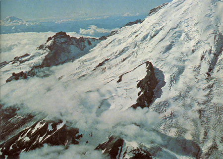
Where did the Osceola Mudflow originate on the volcano? This we must deduce from several lines of evidence. The mudflow occurred so long ago that there is no historical record, and volcanic events since that time have covered up part of the scar it left on the volcano. Remnants of the Osceola Mudflow veneer the sides and ridges of the Glacier Basin, and a small amount of it is even preserved at the top of Steamboat Prow, at an altitude of 9,700 feet (fig. 20). This distribution tells us that the slides responsible for the mudflow originated somewhere on the volcano above Steamboat Prow. But now there is no great chasm in the side of the volcano large enough to have provided a source of the mudflow; so we must consider a former summit of the volcano itself as a possible source.
|
| THE NORTHEAST FLANK of Mount Rainier. A remnant of the Osceola Mudflow lies at the summit of Steamboat Prow in the center. Two and one-half miles to the left is Little Tahoma Peak, from whose steep north face at least seven large masses of rock fell in 1963. Mount Adams volcano can be seen at the left, and Mount Hood, Oregon, in the far distance. (Fig. 20) |
I. C. Russell, one of the first geologists to study Mount Rainier, wrote in 1896 that the present summit of the volcano consists of a small lava cone. Enclosing this cone is a broad depression whose rim is partly preserved at Gibraltar Rock, Point Success, and Liberty Cap (fig. 10; see p. 18). High points on the rim indicate that the former summit of the volcano above an altitude of about 14,000 feet was removed in some way. The destruction of the old summit, which may have reached a height of 16,000 feet, left a broad east-facing depression in the top of the volcano between Gibraltar Rock and Russell Cliff. The depression has since been mostly filled by the recent lava cone. You can see these features best from high points east of the mountain.
Our best explanation of how the former top of the volcano was removed also solves the problem of finding an adequate source of material for the Osceola Mudflow. Before 5,800 years ago, the topmost part of Mount Rainier probably consisted of rock that had been weakened by hot volcanic fumes and solutions and partly converted to clay. Then, this mass of weak rock was jostled off or pushed off by a volcanic explosion and slid down the northeast side of the volcano. One or more of these mighty avalanches of moist clay and rock resulted in the Osceola Mudflow.
Large avalanches have also occurred many times during the last 3,000 years on the west side of the volcano. Sunset Amphitheater (fig. l0; see page 18) is part of the large scar left by them. About 2,800 years ago one of these avalanches created a mudflow in the valleys of the South Puyallup River and Tahoma Creek that was temporarily deep enough to submerge Round Pass (on the West Side Road) to a depth of nearly 400 feet. This is especially remarkable when we see that Round Pass itself is 600-700 feet above the nearby valley floors. Another deep mudflow, started by an avalanche at Sunset Amphitheater, moved down the Puyallup River valley about 600 years ago and buried the site of the present town of Orting in the Puget Sound lowland under 15 feet of mud and rock.
Avalanches and mudflows like those described are normal events at Mount Rainier and are expected to happen again in the future. Almost any cliff on the volcano can produce a large rockfall, but which cliff will collapse next, or when, cannot be predicted. Should the volcano again become active, earthquakes and volcanic explosions would trigger avalanches and mudflows that would rush down the mountain. Molten rock would melt snow and ice at the volcano's summit and send floods of water down the volcano's flanks. These indirect effects of an eruption would be much more hazardous than lava flows and pumice, if eruptions are on scales similar to those of the past 10,000 years. (See Table 2.)
| Geologic time scale | Years ago | Geologic events in the area of the park |
| "Postglacial" |
Present summit cone of Mount Rainier probably was built about 2,000 years ago. The last known pumice eruption occurred between 1820 and 1854. Glaciers started to grow and advance about 3,000 years ago. Maximum extents were reached about 1850 A.D. From then until about 1955, glaciers were receding; now they are in balance or advancing. Huge masses of rock have slid from the volcano repeatedly during the last 10,000 years. One of these destroyed the summit of Mount Rainier and formed the Osceola Mudflow about 5,800 years ago. | |
| 10,000 | ||
| Pleistocene (Ice Age) |
25,000 |
Last major glaciation. Birth and growth of Mount Rainier volcano, and repeated glaciation. |
| 2-3 million | ||
| Pliocene | Uplift and erosion of the Cascade Range. | |
| 12 million | ||
| Miocene Oligocene |
26 million |
Intrusion of granodiorite. Folding of older rocks. Deposition of Fifes Peak and Stevens Ridge Formations. Deposition of Ohanapecosh Formation. |
| 37-38 million | ||
| Eocene | Deposition of Puget Group. | |
| 53-54 million | ||
| <<< Previous | <<< Contents >>> | Next >>> |
bul/1292/sec7.htm
Last Updated: 01-Mar-2005