
|
Geological Survey Bulletin 1292
The Geologic Story of Mount Rainier |
YESTERDAY'S GLACIERS
Mount Rainier's great sprawling cone would seem incomplete without the glistening sheets of ice that descend its flanks. We have reason to believe that the volcano has borne glaciers ever since its origin — sometimes smaller than now, at other times vastly larger. Mount Rainier probably started to grow during the middle part of the Pleistocene Epoch, or Ice Age, which began more than l million years ago, but glaciers had covered this part of the mountains even before the volcano appeared. Masses of rock debris formed by ancient glaciers occur beneath lava flows from Mount Rainier on the west side of Mazama Ridge just upslope from Narada Falls, on the north side of Glacier Basin, and at a few other places in the park
Mount Rainier may have reached its present size by about 75,000 years ago. Since that time great icefields and glaciers have formed at least twice on the slopes of the volcano and in the nearby mountains. During the first of these glaciations, ice completely buried the flanks of the volcano and the surrounding mountains, except for the very highest ridges and peaks. This great ice mass slowly flowed down all the valleys that head at Mount Rainier. The glacier in the Cowlitz River valley, for example, extended 65 miles from the volcano and reached a point about 33 miles west of the community of Randle. Deposits of this glacial episode can be seen in cuts along the Mowich Lake Road for a distance of about 1-1/2 miles inside the park boundary. The glacial deposits were originally more widespread, but in most of the park they have been removed by erosion or covered by the deposits of younger glaciers.
During the most recent major glaciation of the park, which lasted from roughly 25,000 to 10,000 years ago, ice again sheathed the slopes of the volcano, but glaciers in the nearby mountains were smaller than before. Most of the glaciers originated at the valley heads, where they gouged out countless bowl-shaped bedrock basins called cirques. Many of the basins held lakes after the glaciers disappeared. (See page 39.) Hikers on the trail to the Paradise ice caves cross the floor of a typical cirque at the head of Paradise Valley. From the Sunrise Visitor Center at Yakima Park you can walk a short distance to a point along the crest of the Sourdough Mountains and stand at the rim of a deep north-facing cirque. Ice originating in this cirque and in the cirques adjacent to it moved northward down the valley of Huckleberry Creek at least as far as the park's north boundary (fig. 15).
|
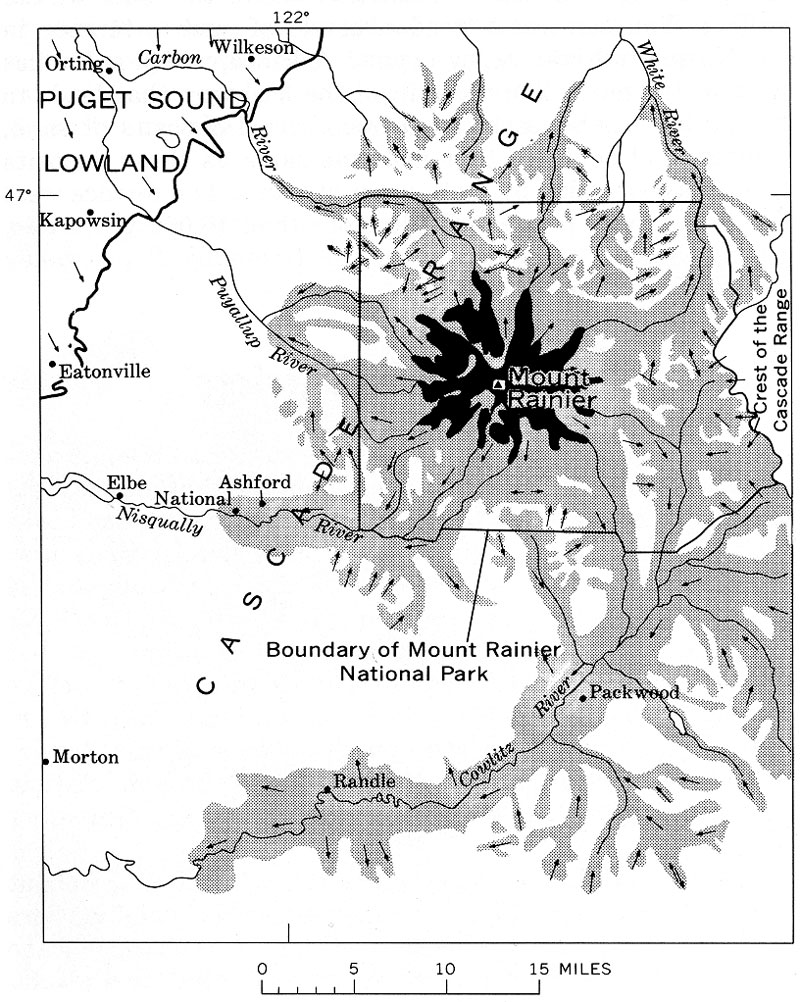
| EXTENT OF GLACIERS in the Cascade Range near Mount Rainier between about 15,000 and 25,000 years ago. Arrows show the direction of ice movement; solid black represents modern glaciers on Mount Rainier. (Fig. 15) (click on image for an enlargement in a new window) |
These glaciers left most valley walls in the park covered with rock debris. Lateral moraines can be seen along the highway at and just east of Ricksecker Point (fig. 16). Other glacial deposits are especially well displayed in roadcuts along the north wall of the White River valley.
|
| LATERAL MORAINE of rock debris at Ricksecker Point. It was formed by Nisqually Glacier when the glacier was at least 1,000 feet thick and about 15 miles longer than it is today. (Fig. 16) |
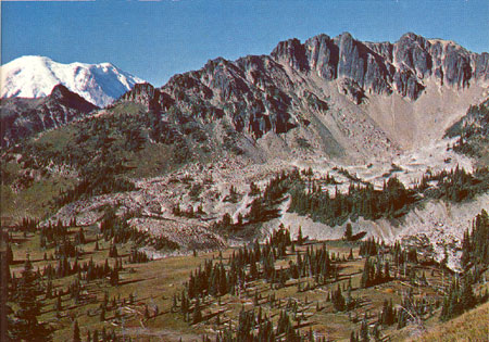
A little more than 15,000 years ago the long glaciers began to shrink and recede. By 11,000 years ago there was only about as much ice on Mount Rainier as there has been within the last century. Then, during a short period of renewed glacier growth, most glaciers expanded short distances and new ones appeared in cirques from which ice had disappeared only a short time before. In some of these cirques so much rock debris was being dislodged from surrounding cliffs by repeated freeze and thaw that a rock glacier, consisting mostly of rock fragments bound together by ice, was formed. A trail to the Huckleberry Creek valley crosses hummocky rock debris left by such a rock glacier in a cirque on the southeast side of Mount Fremont. A larger rock-glacier deposit lies about 2 miles north of Sunrise Point in an east-facing cirque between The Palisades and Hidden Lake (fig. 17).
In other cirques, where the proportion of ice to rock debris was greater, the glacier transported the debris a short distance forward and built a terminal moraine. You can see particularly good examples of moraines formed about 11,000 years ago near Tipsoo Lake, where the pond southeast of the lake is dammed by a moraine, and at Mystic Lake. The ice that formed the terminal moraine at Mystic Lake was a tongue of Carbon Glacier.
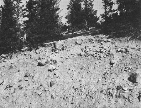
In some places the orientation or altitude of the cirque did not permit enough snow to accumulate to form a glacier but just enough to create a permanent snowbank. Rock debris that fell from the surrounding cliffs rolled down these snowbanks and formed low ridges at their toes. Such a ridge is called a protalus rampart because it is found just in front of the apron of rock fragments, called talus, that lies beneath cliffs. A trail at Sunrise Point leads to protalus ramparts along the north side of Sunrise Ridge.
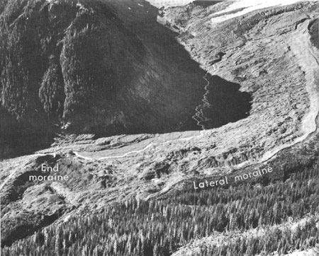
During the last l0,000 years, glaciers have been very small by comparison with the great ice mantles that overwhelmed the park earlier. However, glaciers have grown larger at least twice just within the last 3,000 years. During both of these periods most glaciers were slightly larger than they are today, and ice occupied most cirques at altitudes above 6,500 — even some that are now free of ice. The most recent time of extensive glacier growth began at least 800 years ago, and various glaciers in the park reached their maximum size between the mid-14th century and the mid-19th century. Oddly enough, even though all the glaciers headed on Mount Rainier, they did not all attain their maximum size simultaneously. The largest terminal moraine of this most recent glacial period was built by Emmons Glacier in the White River valley (fig. 18). It is now largely forested, and cores taken from the trees with a special boring tool that does not harm the trees show ages indicating that the moraine was stable enough to permit seedlings to survive on it by the mid-17th century. A similar but smaller terminal moraine built by Cowlitz Glacier has trees on it that started to grow in the mid-14th century.
|
| ROCK-GLACIER DEPOSIT (light-gray rubble beyond the brown slopes in the foreground) at The Palisades, which was formed about 11,000 years ago when the climate was colder than it is today. Rocks fell from the cliffs in such great quantity that a small glacier in front of the cliffs consisted of more rock debris than ice. The melting of the ice left a mass of broken rock several hundred feet thick which covers about 80 acres. (Fig. 17) |
Nearly all the glaciers gradually decreased in size after the mid-18th century. Although the shrinkage was sometimes interrupted by short periods of renewed glacier growth, by l950 the glaciers at Mount Rainier covered only about two-thirds of the area that had been buried by ice only a century before. The overall loss of volume by Rainier's glaciers, as well as those elsewhere in the Pacific Northwest, was slowed or halted by slightly cooler temperatures and higher precipitation starting in the mid-1940's. Volume increases in their upper reaches caused the larger glaciers to grow from year to year, and since the early 1950's the terminuses of many glaciers have been advancing. This renewed growth of glaciers is not unique at Mount Rainier — similar changes have been observed at other glaciers in the Cascade Range and elsewhere.
|
| THE HUMMOCKY END MORAINE at the left still had blocks of ice buried in it when this picture was taken in 1954. The front of Emmons Glacier was near the left edge of the bare moraine in about 1900. Now the glacier ends l mile farther upvalley at the upper right. The valley floor and moraine were buried by an avalanche of rock debris from Little Tahoma Peak in 1963. (Fig. 18) |
| <<< Previous | <<< Contents >>> | Next >>> |
bul/1292/sec6.htm
Last Updated: 01-Mar-2005