|
Fort Vancouver
Cultural Landscape Report |

|
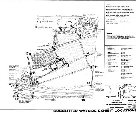
APPENDIX F: LIST OF SUGGESTED WAYSIDE EXHIBIT LOCATIONS AND GENERAL INTERPRETATION TOPICS
A) Core Area:
In addition to wayside exhibits describing the features and operations inside the stockade, provide wayside exhibits for structures and features adjacent to the stockade related to a variety of HBC operations (agricultural, service, industrial) including the following wayside exhibits that:
1) Describe the size and layout of the garden, the garden summerhouse, the variety of plants grown there, and who and how it was used.
2) Describe the size, layout, and types of fruit grown in the orchard.
3) Describe the location of an unidentified building near the orchard and possible agricultural uses.
4) Describe the Cooper's shed, what coopering (barrel making) was about, and the location of other structures adjacent to the Cooper's shed.
5) Describe the root houses on East Fifth Street (historic Upper Mill Road), and what and how crops were stored in the structures.
6) Describe and illustrate (photo) the school houses, and their rental by the U.S. Army.
7) Describe the barn complex and associated agricultural operations.
8) Provide a viewpoint and description of the overall fort landscape and Vancouver Barracks parade ground, from a pedestrian path.
9) Provide a viewpoint and description of the overall fort landscape from a vehicle pullout.
10) Describe the Vancouver Barracks parade ground and the area's prior historic use as a Hudson's Bay Company pasture and field.
11) Descriptions of the livestock pasture and HBC livestock operations.
12) Describe the historic roads to the historic Mill Plain and the extent of the HBC property.
13) Provide a viewpoint of the fort landscape and description of Fort Vancouver operations from the proposed access at the southeast side of the park.
B) Kanaka Village:
14) Exhibits that describe the full extent of development at Kanaka Village (boundaries, roads, structures, small-scale features).
15) An exhibit describing the critical connection of the fort to the Columbia River and historic roads that led to the HBC river front area.
C) U.S. Army Vancouver Barracks property:
In cooperation with the U.S. Army, construct interpretive wayside exhibits to interpret the HBC resources and U.S. Army resources located on the property that is currently owned by the army.
16) Vancouver Barracks development and the area's prior historic use as a HBC service/civic area, including structures such as the grist mill, stable, and Ryan's.
17) The Vancouver Barracks development and location of HBC dwellings, and St. James Mission.
D) River Front Area:
18) Establish wayside exhibits that highlight the historic routes from the river to the stockade, and the type, and number of historic structures and associated activities that occurred at the river front in the historic period.
19) Establish a wayside that describes the Columbia River ecosystem and the use and appearance of the shoreline before and during the HBC historic period.
20) Locate wayside exhibits and describe the HBC structures (servant's dwellings and Modeste stable) located at the east end of the river front area.
E) Historic Apple Tree Park (City of Vancouver property):
21) Exhibit describing Fort Vancouver N.H.S. and the historic connection of the fort to the Columbia River.

|
| Suggested Wayside Exhibit Locations. (click on image for an enlargement in a new window) |
| <<< Previous | <<< Contents >>> | Next >>> |
fova/clr/clr1-af.htm
Last Updated: 27-Oct-2003