|
Fort Vancouver
Cultural Landscape Report |

|
III. ANALYSIS AND EVALUATION (continued)
HISTORIC CHARACTER DEFINING FEATURES (continued)
CLUSTER ARRANGEMENTS

|
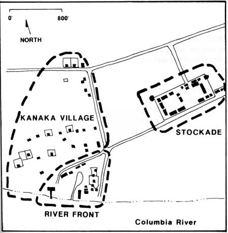
| Schematic map of the western third of historic Fort Plain showing cluster arrangements. |
Clusters of buildings at Fort Vancouver were characterized by groupings of individual features and structures defining land use activities and overall historic landscape organization. There were three distinct concentrations of features at Fort Plain, the stockade, Kanaka Village, and the river front area.
Stockade
From its beginning, the stockade served as the heart of Fort Vancouver, containing the primary cluster of structures that were essential to the wide variety of trading and farming operations. The stockade expanded several times during its existence. The new stockade, constructed on Fort Plain in 1829, was roughly a square enclosure, 320 by 318 feet, that contained nine to eleven structures during the period between 1829 and about 1836. Buildings were arranged along the interior edges of the stockade, generally in a U shape, with the open end of the U along the north wall (the Chief Factor's House may have been centered at this end). The only gate in the stockade was located approximately in the center of the south wall. Other structures included privies, several fences, a well, a belfry, and a flagstaff.
Activities in the open space of the stockade were noted as "... all the indoor work of the establishment...", and included an assembly area for Indians with their various trade articles, a work area where Canadian employees beat the furs, and on at least one occasion, a round-up corral for horses.
Between 1834 and 1836, the stockade was enlarged to the east an additional 180 feet to an overall size of 660 by 318 feet. A new gate was added on the south and north side of the structure. The interior now consisted of two open spaces or courtyards; the original western courtyard, and the new eastern courtyard which was surrounded by new buildings. By 1841, there were at least twenty buildings and a number of new small-scale features, including cannons that were located in front of the Chief Factor's House.
Between 1841 and 1846, when Fort Vancouver had reached its maximum development and influence, the stockade measured approximately 734 by 318 feet. During this period several new structures were built including a bastion, bake house (third), iron store, and storehouse. In addition, the uses of some existing buildings changed. The spatial organization still essentially consisted of two courtyards, although there were only two buildings remaining on the east side of the west courtyard. In 1846, one of these remaining buildings, the old Catholic church, was demolished. After the old office was demolished, probably after May of 1847, the interior of the stockade became, and remained until 1860, one large, open courtyard.
Small-scale features in the stockade in 1844 included privies, a belfry, a flag staffs, three wells, two cannons, and numerous fences. Research suggests that the surface material in the stockade was primarily dirt and possibly some volunteer native grasses. Other than the small gardens and grapevines at the Chief Factor's, the interior was devoid of vegetation.
Between 1846 and 1860, more changes occurred at the stockade. The stockade reached its largest size, approximately 732 by 325 feet, old buildings were replaced and some new ones added, and some building functions changed. Although research indicates some maintenance of the buildings continued in this period, lack of resources to maintain the fort as a whole, also affected the stockade. By 1853-54, the buildings were apparently old and decayed, with only minimal maintenance measures in force. When the fort was abandoned in 1860, twenty-two structures were still standing, but most were described as "uninhabitable" or in a "ruinous condition".
Kanaka Village
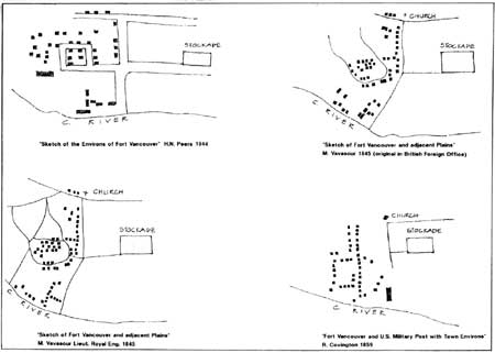
The overall organization of Kanaka Village remains sketchy. Historic maps, with their small scales and widely varying orientations, offer little consistency in determining any details about exact dwelling locations or road patterns. The village may have been organized along streets or lanes according to the occupants' nationalities. For example, in 1843 it was noted that "In the lower town was a street for Canadians, one for Kanakas, and one for English and Americans." Documentation indicates dwellings were located along the river road, and on other east-west oriented roads located west of the river road. Several of the dwellings had yards or gardens enclosed by fences, and a corral was located near the intersection of Upper Mill Road and the river road.
Archeological projects have excavated several structures that have been identified according to Covington's 1846 stockade map. "Charlebois's", and "Little Proulx's" dwellings are located along river road, near the intersection of Upper Mill Road. "Billy's", "Kanaka's", and three other structures are located west of the stockade along an east-west running line. Although none of the maps from the 1840s show a road in the area, their siting in an east-west oriented direction and the existence of a road in this location on the 1851 Gibbs's sketches, indicate a road was located south of the buildings. Other excavated dwellings south of the above structures include, one identified as "John Johnson's", and two indentified structures. The unidentified structure between John Johnson's and Billy's may be, due to its relative position on the 1846 map, a dwelling occupied prior to 1850, by Joe Tayenta.
River Front
Southeast of Kanaka Village, along the river was another large cluster of buildings related to industrial activities such as, tanning, shipping and storing goods, shipbuilding and repair, coopering, and, for a time, distilling. Employee dwellings, sheds, and stables were also located in the area. The exact locations and number of structures in this area are unclear. According to the 1846 Covington map there were nineteen structures including a horse stable, an ox stable, two pig sheds, five "servants" dwellings, a cooper's shop, two tan pits, a hospital, a salt house, a saw pit, two sheds (at least one a boat shed), and a salmon house attached to a wharf or jetty which extended out over the river. The 1846-47 Company inventory generally agrees with the 1846 map, but does have some discrepancies in the number and sizes of the structures listed.
Overall, the industrial activities were located closest to the river, the stables were along the west and northwest side of the pond, and the dwellings east of the pond. Access to the area was from the river and two roads, Lower Mill Road and the river road. The size, configuration, and location of the pond remain unclear. In 1846, a bridge was shown crossing the narrow pond inlet. Differences in pond characteristics between historic maps may be due, in part, to changes inherent in the rise and fall of the Columbia River.
Cluster Arrangement Summary and Analysis
The three distinct building clusters at Fort Vancouver were characterized by the concentrations of features based primarily on land use activities, materials, circulation, and the overall landscape organization. The stockade, Kanaka Village, and the river front area represented administrative, residential, and industrial land uses. While the stockade cluster is fairly well documented, detailed information remains unclear about the number, type, arrangement, and locations of structures in Kanaka Village and the river front area.
Today, there are no extant historic features remaining from these clusters. The site of Kanaka Village and the river front development have been extensively altered by development including buildings, major roads and highways, and the railroad embankment. In addition, portions of Kanaka Village and the river front area are not within the National Historic Site boundaries. Reconstructions of the stockade and eight buildings provide some understanding of the stockade's internal arrangement, land use activities, and the extent of the stockade's development ca. 1846. Excavated and undiscovered 'in situ' features, in all three cluster arrangements, possess significant archeological integrity.

|
| Schematic drawings of Kanaka Village showing the variety of layouts depicted on different historic maps. (click on image for an enlargement in a new window) |
| <<< Previous | <<< Contents >>> | Next >>> |
fova/clr/clr1-3a6.htm
Last Updated: 27-Oct-2003