|
Fort Vancouver
Cultural Landscape Report |

|
II. EXISTING CONDITIONS
ENVIRONMENTAL CONTEXT AND SETTING
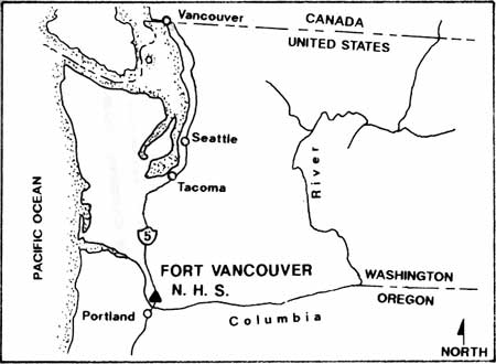
Fort Vancouver National Historic Site is located on the north bank of the Columbia River in Vancouver, Washington. Historically, the natural landscape of Columbia River's north shore was a mosaic of plains, coniferous forests, streams and lakes, with the Cascade Mountains visible in the distance. The fort stockade, the heart of the Hudson's Bay Company (HBC) operations, was located on a low-lying river plain called Fort Plain, that was approximately six miles upriver from the confluence of the Columbia and Willamette Rivers. The abundant natural resources and strategic position on the Columbia River set the stage for the site's political and economic importance beginning with the British Hudson's Bay Company, and continuing with the U.S. Army's occupation and American settlement of the Pacific Northwest. Today, the park contains approximately 208 acres and includes resources that relate to both the HBC occupation and the U.S. Army's Vancouver Barracks.
|
STUDY BOUNDARIES
Fort Vancouver National Historic Site, located in Vancouver, Washington, was established in 1948 to protect and maintain the site of the Hudson's Bay Company stockade and sufficient surrounding land to preserve the historic scene. The park was established within the boundaries of the Vancouver Military Reservation and contains land owned by both the National Park Service (NPS) and the U.S. Army. The current park boundaries include only a portion of the once vast territory that was controlled by the Hudson's Bay Company.
|
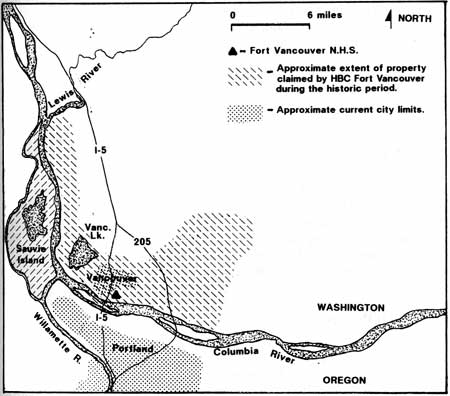
At its height in the 1840s, Fort Vancouver consisted of thousands of acres of forests and plains, extending for twenty-five miles along the Columbia River, and stretching north from the river for distances varying from four to fifteen miles. Principal operations took place on three large natural plains named Fort Plain, Lower Plain, and Mill Plain. Five additional plains, First Plain, Second Plain, Third Plain, Fourth Plain, and Camas Plain (referred to as the Back Plains), located north and east of the three large plains, were also periodically farmed. This area extended along the Columbia River from today's Vancouver Lake beyond Interstate 205. Although Fort Vancouver ultimately expanded to this vast area, the initial development occurred on Fort Plain, which became the administrative and geographical center of Fort Vancouver. Today, Fort Vancouver National Historic Site encompasses what was historically the core developed area of Fort Plain (approximately the western third of the historic plain).
1992 CONTEXT MAP
|
| Map showing the extent of historic HBC Fort Vancouver development relative to existing development. |
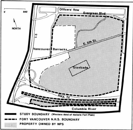
In order to set the appropriate historical context for all periods of development, this report includes several scales of resolution. The majority of the historical research and the analysis and evaluation focus on the historic Fort Plain, and more specifically, the western third of historic Fort Plain. This encompasses the area between Evergreen Boulevard and the Columbia River, and between Interstate 5 and East Reserve Street. The character areas and management zones narrow the focus of the report to the National Historic Site boundaries. The design recommendations are specific to property owned by the National Park Service.
| <<< Previous | <<< Contents >>> | Next >>> |
fova/clr/clr1-2.htm
Last Updated: 27-Oct-2003