

Survey of Historic Sites and Buildings
 |
PLATTSBURGH (Cumberland) BAY New York |
|
| ||
Ownership and Administration. State of New York and city of Plattsburgh.
Significance. In this bay occurred the decisive Battle of Plattsburgh (Cumberland) Bay, September 11, 1814, in which Capt. Thomas Macdonough's fleet, supported by a land force, halted a major British thrust into the United States along the invasion route of Lake Champlain and the Hudson River. The victory compelled British troops to withdraw to Canada and leave behind a vast store of supplies. Giving the United States control of Lake Champlain, it thwarted Britain's last hope of conquering the Great Lakes region or of winning a cession of U.S. territory there.
In 1813, after a successful series of raids on towns along Lake Champlain, the British commander constructed a strong war fleet along its northern shores. Meantime, Capt. Thomas Macdonough, USN, constructed additional ships for his flotilla on the lake to allow him to meet the British fleet. The British plan called for a full-scale invasion down the western shore of Lake Champlain to capture Plattsburgh by a force of more than 11,000 regulars, whose left flank would be covered by the British fleet. Defending Plattsburgh was a small force of about 1,500 troops, supported by Macdonough's newly built flotilla.
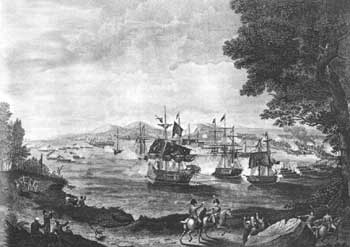
British forces mobilized late in 1814. Their troops drove advancing U.S. forces back to Plattsburgh and forced them to take a position on the south bank of the Saranac River, just south of town. The British commander intended to triumph by a joint land and sea attack. Macdonough had only 4 ships and 10 gunboats, and the British commander had 4 ships and 12 gunboats. However, Macdonough had chosen his position well—in the confined waters of the bay between the peninsula known as Cumberland Head and the mainland, where lay the town of Plattsburgh. In this area the British Confiance, the largest vessel on the lake, would have trouble maneuvering. On the morning of September 11, while U.S. land forces held firm, the British fleet moved in toward Macdonough's fleet, whose flagship was the Saratoga. For almost 2-1/2 hours at close quarters, the fight continued until Macdonough triumphed. The British commander was killed, and Macdonough was twice knocked unconscious. Demoralized by the naval defeat, his flank unprotected and his supply lines endangered, the commander of the British land forces withdrew his troops to Canada, and left behind a large store of supplies.
 |
| Thomas Macdonough's fleet clashes with the British at Plattsburgh Bay, in Lake Champlain—a major U.S. triumph in the War of 1812. From an engraving by B. Tanner, after a painting by H. Reinagle. Courtesy, Library of Congress. |
Present Appearance. Plattsburgh (Cumberland) Bay is formed by the peninsula of Cumberland Head on the north and east and by the mainland on the west, where the town of Plattsburgh is situated. The bay's open end, facing south, is about 1-1/2 miles wide. The beach area on Cumberland Head provides a fine view of the site of the naval battle in the bay. A good all-weather road encircles the head, at the tip of which is a dock for the ferry that links the New York and Vermont shores of Lake Champlain. The head is a residential area, although much of it is relatively undeveloped. The town of Plattsburgh has grown over and obscured the sites of the land battle. On its bayfront is the Macdonough Memorial, a 135-foot-high obelisk of Indiana limestone decorated with reliefs of symbolic naval scenes and a list of the U.S. ships that won the Battle of Plattsburgh Bay.
NHL Designation: 12/19/60
 |
 |
http://www.cr.nps.gov/history/online_books/founders-frontiersmen/sitec30.htm
Last Updated: 29-Aug-2005