


Survey of Historic Sites and Buildings
 |
CASSELMAN BRIDGE (National Road) Maryland |
|
| ||
Ownership and Administration. Garrett County.
Significance. This bridge over the Casselman River is a fine example of the state of the bridge-building art at the time of the construction of the National, or Cumberland, Road—in the first half of the 19th century a major east-west artery of emigration and commerce between the Atlantic States and the northern Mississippi Valley. The bridge, whose stone arch was the largest in the United States at the time of its erection, in 1813, typifies the numerous stately stone bridges whose handsomely turned arches were as characteristic a scene on the road as the iron mile-posts, iron gates, and wooden bridges.
The Congressional Enabling Act in 1802 that created the State of Ohio (1803) specified that a national road be built from Cumberland, Md., to Wheeling, W. Va., on the Ohio River; a later act called for funds from the sale of public lands in Ohio to be used for financing the road. Cumberland was chosen as the eastern terminus because the Frederick Pike already linked Baltimore and Cumberland. In the spring of 1811 construction began, under the supervision of the War Department. Gangs of men, wielding picks and shovels and driving oxen and horses, cleared a 66-foot strip for the roadway, leveled hills, and filled or bridged hollows. They covered 20 feet of the 30-foot-wide road with stones, at least a foot deep. Interrupted for only a short period during the War of 1812, by 1818 workmen had angled the road northwestward through Pennsylvania and reached Wheeling. This remained the western terminus for some years, partly because an extension was not so critically needed as the eastern part of the road and because many westward emigrants used Ohio River steamboats.
In 1820 Congress surveyed a route west of Wheeling and 5 years later appropriated money for an extension of the road. In 1825—26 workers, following the old Zane's Trace, extended the road to Zanesville, Ohio. By 1833 additional congressional appropriations had made possible an extension to Columbus and by 1837 to the Indiana border. Finally, in 1852 the road reached its final western terminus, at Vandalia, Ill.—a distance of 834 miles from Cumberland. The route of the road is generally followed today by U.S. 40.
The short Maryland section of the road had barely been completed, during the War of 1812, when the flow of traffic began in both directions—cargo carriers of all sizes, some drawn by 12 horses and carrying 10-ton loads, stagecoaches, Conestoga wagons, droves of animals, and emigrants. At night the travelers rested at the numerous inns and taverns. The heavy traffic, landslides, and rainstorms created the need for regular repairs. In the 1820's and 1830's laborers had to practically rebuild the road. Upon the completion of repairs in 1831, the Federal Government turned the Maryland section of the road over to the State—and later did the same for the other States involved. They all inaugurated toll charges for the use of their sections of the road, whose importance and use declined after 1850 because of the growth of canals, railroads, and the telegraph.
Casselman Bridge continued to be used until 1933, when the State replaced it with a nearby modern steel-and-concrete structure. It is a Registered National Historic Landmark relating primarily to travel and communication.
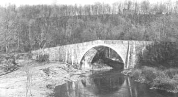 |
| Casselman Bridge, Maryland, an arched bridge built along the National, or Cumberland, Road. At the time of its construction, in 1813, its large stone arch was a major engineering accomplishment. |
Present Appearance. Casselman Bridge is in sound condition. In 1911 the State repaired it, but it is essentially the same as when built. It is now owned by Garrett County and is located in the center of a small park.
NHL Designation: 01/29/64
 |
 |
http://www.cr.nps.gov/history/online_books/founders-frontiersmen/sitec18.htm
Last Updated: 29-Aug-2005