|
Colorado
A Classic Western Quarrel: A History of the Road Controversy at Colorado National Monument |

|
CHAPTER THREE:
The Otto Years: 1911-30 (continued)
Road Building, 1911-1927
Road building continued to be a mutual interest for park promoters and non-promoters after Colorado National Monument was established. The communities of Grand Junction, Glade Park and Fruita pushed to build a road to Glade Park, while Otto and the Grand Junction Chamber of Commerce worked for a scenic route through the park. The nature of road building to and through the park revealed that local and park transportation needs were closely linked.
Each of the Grand Valley's communities had practical and economically motivated transportation needs. In 1909, the newly formed State Highway Commission accepted plans for two state roads in Mesa County: a route from Grand Junction to the Utah state line and one from Grand Junction to Montrose. [182] The county commissioners and Grand Valley automobile owners backed the Midland Trail (today's I-70), the desert route from Grand Junction to Utah that competed with Otto's Union Trail. In 1912, a portion of the Midland Trail from Mack to Utah was completed, thus eliminating the Grand Valley's isolation from the rest of the country. [183]
Other road proposals were less dramatic in scope. Citizens of Fruita met in December, 1911, to discuss the possibility of building a better road from Fruita to Glade Park for the purpose of generating business relations with that area. [184] In April, 1912, Glade Park residents petitioned the county commissioners for a "road through No Thoroughfare Canyon and also submitted a survey showing the location of the road." [185] Glade Park was still working to find a better route to Grand Junction on which to drive cattle and transport farm goods. [186] In December 1912, Otto joined the effort to construct a road to Glade Park, when he, John G. McKinney, and William C. Hermann formed the Colorado River Auto Transportation and Toll Road Company. Its purpose was to "build, construct, operate, and maintain a toll road" from Grand Junction, through No Thoroughfare Canyon, and up the rim rocks toward Glade Park. [187]
Developing transportation in the Grand Valley was intertwined with the effort to build a scenic road through the Colorado National Monument, a fact that became problematic as the park developed, and as the communities grew and their needs changed. Due to its location, the Monument was a natural thoroughfare between Grand Junction and Glade Park, so it was logical to build roads that served both as scenic routes for the park and as access to the Grand Valley.
The original promoters of the Monument—Representative Taylor, John Otto, and the Grand Junction Chamber of Commerce—were instrumental in working to build a road through the park. Taylor introduced a bill on June 8, 1911, "for the construction of a National Road from Grand Junction, Colorado to and through the Colorado National Monument." [188] Although the bill did not pass, it requested an appropriation of $20,000 for the construction of the road to be "built under the direction of the Secretary of the Interior." [189] Response to the bill indicated that the economic potential of the road was important:
The construction of this road will mean much to Grand Junction in that it will mean a way of reaching the park by a good road by automobile. This means that thousands of visitors will see the park where only hundreds would in other large parks of natural wonders, tourist traffic is a prominent feature of summer traffic. [190]
Taylor introduced the same bill in every session of Congress between 1911 and 1917. The final attempt in April 1917 also failed. The rejection of Taylor's bills reflected governmental and congressional attitudes toward national parks in general. Prior to the creation of the National Park Service in 1916, Congress had little interest in developing the parks. [191] In fact, Congress did not appropriate any money for national monuments until 1916—ten years after the Antiquities Act passed. [192]
Despite the lack of legislative support, the campaign for a road continued. The first substantive efforts toward building a road through the Colorado National Monument were part of Otto's plans to include the Monument in a transcontinental highway known as the Union Trail. The Union Trail was designed to stretch from Grand Junction's Main Street Bridge, through the Colorado National Monument and the plateau country of Pinon Mesa, toward Moab, Utah. The section of the road that would eventually traverse the park essentially followed the same route but acquired several names: Rimrock Route, Otto's Road, Glade Park Road, and the Grand Rimrock Boulevard. [193]
More commonly referred to as Glade Park Road or Rimrock Route, this section of road was supposed to perform numerous functions: a route to Glade Park, a scenic drive, and a stretch of the transcontinental highway. Otto estimated that $1000 would be needed to construct it, but the $100 he had already raised would be a good start. He also took the time to challenge any engineer to survey a better route. [194] Mesa County Engineer James Fisk surveyed and approved of Otto's proposed route just days later. In his description of the road, Fisk commented that "there is one place where the traveler looks straight down for 400 feet into the depths of the Monument Park." [195] He estimated that for $6500 it could be built and would be an "important step toward development for this city" as well as a road of the "greatest scenic beauty," indicating that, from the start, the road served a dual purpose. [196] Although Otto started blasting for the road in January, 1912, it was not clear how much construction could take place before the limited funding ran out. [197]
In January, 1913, Otto wrote to the Commissioner of the General Land Office hoping to secure money for additional construction:
The world's greatest driveway shall be built on the top of the shelfrocks overlooking the National Monuments named after our great men in history. We hope that the department can recommend to congress an appropriation be made; Congressman E. T. Taylor has a bill on the calendar I believe. [198]
A report filed by the General Land Office echoed Otto's belief about the importance of a road through the park. General Land Office employee J.E. Connolly stated that, "unless some money is expended on the building of such a road or trail as will enable the ordinary citizen to wander at some convenience through it," the Colorado National Monument would probably not "become of great public interest" any time soon. [199] Connolly concluded his report by suggesting an appropriation of $300 for a caretaker's residence, and $800 for the "purpose of constructing roads or trails to the monument." [200] The request appears to have been denied.
The politics of road building had a strong impact on the success of this road proposal. Otto and the Grand Junction Chamber of Commerce maintained a stormy relationship during these years. Competition between Otto's Union Trail, which the chamber felt was a "hopeless" endeavor, and the chamber's Midland Trail created a rift in the relationship. Otto believed that his route through the plateau country of Pinon Mesa was far more scenic than the chamber's Midland route that ran from Grand Junction through the desert to Utah. The chamber at first supported Otto's route, and then publicly denounced it. In Otto's assessment, the chamber was a "tin-horn road organization, automobile crazy beyond all hope." [201] At one point he even threatened to quit his work on the Rimrock Route.
Despite these differences, the Grand Junction Chamber of Commerce took an active interest in constructing a scenic route through the park. When Otto's exhaustive requests for appropriations continually failed, the chamber began its own campaign to gain support from the General Land Office and the Secretary of the Interior via Congressman Taylor. In January, 1915, the chamber wrote to Taylor requesting an appropriation for the construction of a 25-mile road through the park "that would surpass in scenic attractions any other road in Colorado." [202] Whether or not the plans for this road extended beyond Otto's route for the Glade Park/Rimrock Road is not known. The chamber estimated that $25,000 "would complete it fit for motor travel." [203] A "national park committee" consisting of people appointed to "have charge of the affairs of the park" who planned to "assist the government and the community" in developing the Colorado National Monument, was also created by the chamber. [204] Taylor's response was not positive. His attempts to acquire appropriations had failed, and he knew that it would be impossible to obtain any money from Congress for road building.
The Daily Sentinel also joined in the "road fever" by waging a fierce campaign during the fall of 1916 to promote the park and raise money for its development. Offering $25 toward park improvements, the Sentinel appealed to citizens of Mesa County to do their part:
If our people would take hold of this proposition, properly fence it, add some conveniences, widen and strengthen John Otto's wonderful trails, improve the roads from the city to the canyon and do a consistent and effective amount of advertising, we believe that in a comparatively short time the Monument Park would attract as many tourists each summer as the Garden of the Gods. [205]
The Grand Junction Chamber of Commerce, the local women's club, the county commissioners, and even the Rio Grande Railroad responded to the newspaper's plea by organizing fund raisers, publicity opportunities, and actively improving the park. May 2, 1916, was declared "Good Roads Day," a time for local "businessmen, professional men, laborers, and everybody else" to work on an approach road to the Colorado National Monument's east end. [206] in early November, 1916, a meeting was called in which George Bullock, chairman of the Grand Junction Chamber of Commerce, was put in charge of the "Monument Park Development." With a donation of $100 to $200 from the Sentinel, this group hoped to "develop the park, trim the trees, erect a small rest room, [and] place benches under the trees." [207]
The road through the park was the most important element of the committee's proposed development plan. By December, 1916, the Grand Junction Chamber of Commerce Monument Park Road committee had mapped a route through the park that, again, was most likely parallel to, or part of, Otto's earlier survey for the Glade Park/Rimrock Road. [208]
Other groups joined the push for the road as well. The general passenger agent of the Denver and Rio Grande Railroad, Frank Wadleigh, commented that a road through the park would attract more tourists. [209] The Mesa County commissioners were approached by a committee including John Otto and other promoters to request that the approach roads to the park be maintained. [210] Glade Park ranchers even agreed to pledge $1500 for the construction of "John Otto's Rimrock" provided the county commissioners would also supply funds. Tired of the poor road conditions from Glade Park to Grand Junction, they were willing to contribute labor and money for an improved route, even if it happened to be a scenic road. [211] By this time, George Bullock of the Grand Junction Chamber of Commerce planned to travel to Washington to "plea for aid for the Monument National Park" with National Park Service Director Stephen Mather. [212] Unfortunately, like most attempts to acquire funds for park improvements, this too was unsuccessful.
In June, 1917, the United States entered World War I, a conflict that interrupted local financing of road projects in the park but eventually contributed to road building efforts in the Grand Valley. Throughout 1917 and 1918, there was very little newspaper publicity regarding the road. The Grand Junction Daily Sentinel reported on a few of Otto's schemes, but its campaign to develop the park was nonexistent. By the middle of 1918, however, western Colorado was suggested as an appropriate spot for an internment camp for German prisoners-of-war. The Germans housed there would be an ideal labor force for the building of roads throughout the Grand Valley. Roads were needed to "help the government win the war" by providing routes for the transportation of produce and other goods from the Grand Valley to other regions. [213] In support of the idea of prisoner-of-war labor, Otto wrote to Congressman Taylor and revived the issue of a road through the park: "what good will a national park be to us unless there are the proper highways to connect up to it?" [214]
After the war, the community revived its efforts to build a decent route to Glade Park that would also serve as a scenic road through the park. Years of unsuccessful road proposals and failed attempts to acquire government support for the road prompted community members to take matters into their own hands. In July, 1919, G.F. Hinton approached the Mesa County commissioners with a petition signed by 60 residents of Glade Park who offered nearly $800 for the construction of a road. Clearly not interested in the proposal, the commissioners did not address the road idea until July, 1920, when Glade Park residents submitted yet another petition. This time, however, the residents stated that they would furnish $5200 for the construction. The county agreed to this, provided that it was not obligated to begin the road until the money was raised. [215]
A series of meetings between the county commissioners and local residents led to the eventual construction of a road, that probably began where construction on the original Glade Park Road had ended. In September, 1920, Glade Park rancher and engineer Bruce Claybaugh agreed to survey No Thoroughfare Canyon's road-building potential. Otto met with the county commissioners to suggest his Union Trail as a possible route. Eventually, the commissioners requested that Claybaugh survey both No Thoroughfare and the Union Trail. In November, the commissioners advertised bids for road construction on both routes. No one responded to the advertisement until December, and even then, only two contractors submitted bids. Contractor W. Wear proposed to construct the road for two dollars per cubic yard of material, while L.S. Shaw stated that he could build the road for an overall sum of $14,500, or for one-and-a-third dollars per cubic yard of material. On December 10, the county awarded the contract to J.S. Shaw. [216]
Even though it hired Shaw, the county still insisted that Glade Park raise $5200, or its equivalent in escrow, before construction began. In January Glade Park residents collected $5,375, and promised an additional $200 to $300. In February, the county directed the road supervisor to assemble a volunteer work force from Glade Park. [217] The county worked on the lower end of the proposed road and the ranchers started work in the higher elevations. [218] The road itself wound through difficult terrain:
The man who does not understand engineering may well take off his hat to the engineer who has the possibility of an auto road to such a spot. It is about 300 ft. straight up in the air from the bottom to the rimrock and underneath the foot there is nothing but solid rock with great canons on either side. [219]
Local volunteers proceeded to work on the road. Work on the road was carried out by local volunteers. A "gang of men" under the direction of Claybaugh began blasting despite concerns about the route's difficulty. Claybaugh dismissed these concerns by stating that most of the work would be done on sandstone that yielded easily to dynamite. The total estimated cost of the road was $12,000. [220] All of the work on the road—drilling, blasting, rock hauling—was done by hand. [221] The county formally organized the Glade Park ranchers and paid them $2.50 a day until April, when poor economic conditions forced wages down to 40 cents a day. The final cost of the road was $3,165, which the county paid to J.S. Shaw in July, 1921. [222]
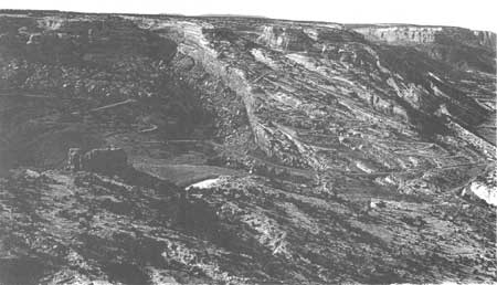
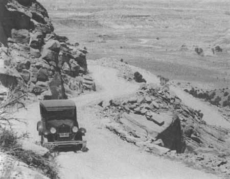
Known as the Serpents Trail, the road was significant for a number of reasons. With its 52 switchbacks, the physical reality of the road was awesome. [223] It was 19 feet wide, with room for two cars to pass, and only one blind turn. By 1925, when it was done, hundreds of people had driven up and down its winding "serpentine" path. [224] At this time, only the upper 2-1/2-mile portion of the road lay within park boundaries; the rest of the road was eventually considered a county route.
The Serpents Trail, like most of the early road proposals, served a dual purpose. It was used twice a year by Glade Park ranchers as a stock driveway to Grand Junction, and as a general transportation route between Glade Park and Grand Junction. [225] The road considerably shortened the distance between the Pinon Mesa/Glade Park region and the stockyards in Grand Junction. To Otto and the future of the Colorado National Monument, however, the Serpents Trail was more than just a county road. It represented the first successful attempt to make the wonders of the park accessible to visitors. Otto already envisioned that the Serpents Trail would continue "around all the rims of the various canons of the Colorado National Monument and beyond." [226] Neither Otto nor local residents could envision, however, that this narrow road would cause the trouble it did once the park was fully developed, and community needs shifted.
Additionally, the construction of Serpents Trail shaped local perceptions of the National Park Service. Even though a portion of it ran through the national monument, the road was entirely funded by private and county dollars. The Park Service contributed nothing to this project. Consequently, local residents felt that the Park Service was not doing its part to develop the park, which was true. W.M. Wood of the Grand Junction Chamber of Commerce wrote to the Director of the National Park Service in 1923, clearly disgusted with government inaction:
All money spent on this Monument to date, with the exception of a very small amount, has been raised by public subscription and from the Chamber of Commerce funds and we feel that we have developed it to such a stage that the Government should be willing to pay something toward its maintenance and upkeep. [227]
The construction of Serpents Trail served as a catalyst for continued road building through the park. In 1926, the idea for a road connecting the western and eastern ends of Colorado National Monument emerged. Fruita's mayor, Frank Merriell, requested Park Service aid in constructing a road from town to Fruita Canyon. Because 2-1/2 miles of this road remained outside park boundaries, the Park Service replied that it could only fund the stretch of road within the park provided an estimate was sent. [228] The Grand Junction Chamber of Commerce developed this Fruita road proposal further by suggesting to the Park Service that the road be extended through the park to connect with the Serpent's Trail to create a complete "highway around the rim." [229] A road between Fruita Canyon on the far western end of the park and the Serpent's Trail on the eastern end would span the entire park. In August 1926, A. E. Demaray, Acting Director of the National Park Service, arranged for an inspection of the proposed road so that a "recommendation could be made to the Director regarding inclusion of it as a project in a further National Park Service road program." [230] By this time, however, citizens of Fruita were exasperated with bureaucracy. They did not support Merriell's road around the rimrocks, believing that the continued push for roads up to Fruita Canyon was a waste of time and money. More effort, they stated, should be directed toward enlarging the Fruita reservoirs and repairing the Fruita water pipeline on Pinon Mesa that supplied the city's water. [231] Yet, despite the initial lack of enthusiasm, this road idea eventually gained both local and federal support.
|
| Figure 3.1. Aerial view of Serpent's Trail (right) and Rimrock Drive (left). Colorado National Monument Museum and Archive Collection. |
|
| Figure 3.2. Car ascending Serpents Trail. Colorado National Monument Museum and Archive Collection. |
| <<< Previous | <<< Contents >>> | Next >>> |
colm/adhi/adhi1-3a.htm
Last Updated: 09-Feb-2005