|
CRATER LAKE
Circular of General Information 1936 |

|
OREGON CAVES
National Monument
Located 160 miles west by south of Crater Lake, the Oregon Caves National Monument in Josephine County, under the jurisdiction of Crater Lake National Park, is one of the most popular scenic attractions in southern Oregon. The monument is in the heart of the Siskiyou Mountains which rise 4,000 feet above the sea.
Discovered by a bear hunter, Elijah Davidson, in 1874, the caverns, with several miles of winding passageways, large rooms and scores of fantastic formations, are unique and offer subterranean scenic thrills long to he remembered. During recent years numerous improvements have been completed to make the caves more accessible and visits more enjoyable.
The monument, including 480 acres, was established by proclamation of President Taft July 12, 1909, and was placed under the jurisdiction of the Siskiyou National Forest where it remained until 1933 when it was transferred to the National Park Service.
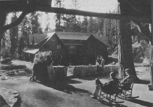
The Oregon Caves Chateau.
Travel increased rapidly with the completion of a modern highway to the monument in 1926. Visitors are attracted by the fact that the caves are different from other caverns in the variety and beauty of their incrustations. They are formed in limestone, but here the rock is a high-grade marble and the constant action of underground water through many thousands of years has resulted in many unusual formations. They assume odd, grotesque, and fantastic forms resembling draperies, flowers, fruits, human forms, monsters, and gargoyles.
Here and there in sparkling beauty are exquisite miniatures of Niagaras, Gardens of Eden, cotton blossoms, forests, and castles. A number of the unusual features carry strange names, such as The Prison Cell, Satan's Backbone, Music Room, Bottomless Pit, River Styx, Heavenly Boudoir, Satan's Caldron, Lion's Jaw, and Paradise Lost. The last named is perhaps the most unusual formation to be found in any cavern and through the use of colored lights is made even more beautiful. This feature is located in a room 60 feet high, the walls of which are covered with awesome incrustations formed by the constant action of water.
The largest column in the caves, the joining of a stalagmite and stalactite, is estimated by some to be 80,000 years old. It is approximately a foot in diameter and is believed to be the oldest formation in the caverns.
A starting point for a trip to the Oregon Caves is Grants Pass, Oreg., at the junction of the Pacific and Redwood Highways and entails a journey of 50 miles, of which 30 miles are on the Redwood Highway and the remaining distance over a surfaced road from the Redwood route from a small settlement known as Caves City. From the south, visitors pass through Crescent City, Calif., 80 miles away.
A new chateau, recognized as one of the most attractive resort buildings in the West, provides lodging and dining-room service at reasonable rates. From the floor of a canyon, the six stories of the chateau rise in majestic beauty in complete harmony with the forests and moss-covered rock ledges of the surrounding country. A mountain stream wends its way through the spacious dining room, with the music of the waters blending with the rhythm of the dinner orchestra.
Housekeeping cabins are also available at the caves and a well-equipped camp ground is nearby. During the summer months, from June 15 to September 1, guides make regular explorations of the caverns, each trip consuming approximately 2 hours. The monument, however, is open throughout the year and accommodations are always available.
LAVA BEDS
National Monument
Located 105 miles south of Crater Lake in northern California, the Lava Beds National Monument, under the jurisdiction of Crater Lake National Park since 1933, covers an area of 46,000 acres in Modoc and Siskiyou Counties. The monument has several features of distinctive importance, especially so in regard to geological, archeological, historical, and general scenic aspects.
A vast field for geologic study is included in this area where centuries ago volcanic activity seethed in lava rivers of liquid fire issuing forth from cinder cones and fissures scattered over the entire section. Geologically speaking, the region is considered very young, the age of the last lava flow being estimated at 5,000 years. There are still a number of hot places to be found near the monument, indicating that underground rocks are probably still molten.
Viewed from a distance, the monument appears as a fairly level terrain, sloping to the north and interspersed with symmetrical cinder cones. Fumaroles similar to the fire mountains of Kilauea volcano in Hawaii are numerous. Much of the surface of this region is soil covered. Billowy lava flows, known as pahoehoe, have spread out like thick molasses or tar. It is in this type of lava that the caves and tunnels are found. These were formed by the hardening of the surface and walls of the flow which became a tube when the still molten lava core drained out. The tubes or caves range in length from a few feet to several miles and from 10 to 75 feet in height. The collapsed portions form long serpentlike trenches of broken rock 20 to 100 feet deep and 50 to 250 feet wide, while narrow unbroken strips of the roof serve as natural bridges.
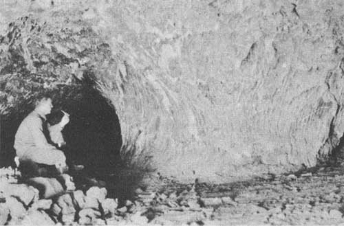
One of the pillars in Catacombs Cave, Lava Beds National
Monument. Courtesy Forest Service.
Two types of symbolic Indian writings add a touch of mystery to the monument. One type is made up of painting (pictographs) with red, yellow, and green ocher on the walls of the caves and the sides of the natural bridges. The other type is made up of carvings (petroglyphs) confined entirely to rocky bluffs where the rocks were sufficiently soft to be chipped by stone tools. The petroglyphs, located in an isolated portion of the monument, are deeply carved in the rock and colored with ocher. The meaning of these ancient writings has not yielded to translation.
An historical feature of the monument recalls the only major Indian war ever fought on California soil and one of the most costly in the United States. In 1872-73 a small band of Modoc Indians under the leadership of Keintpoos, commonly known as "Captain Jack", clashed with a body of United States Cavalry just north of the California line. Later, along with other Indians, the Modocs established themselves in a natural lava fortress in the northern part of the lava beds where they held out against a superior force of soldiers for 5 months.
Still standing as they were built over 60 years ago, stone fortifications used by the soldiers are one of the battlefield features, as well as the caverns in which the Indians lived during the long siege. Bits of rotting leather and bleaching bones are yet to be found on the grounds. Neatly painted signs direct visitors to the main points of interest.
The Lava Beds National Monument is easily accessible. Indian Wells, the administrative center, is approximately 70 miles from Alturas, Calif., on a main traveled highway, and 45 miles from Klamath Falls, Oreg. It can also be reached over dirt roads from Beiber, on the Redding-Alturas Highway, Mount Shasta City, and Bartle, via Medicine Lake.
The monument, as a whole, is in line for considerable development and it is probable numerous road improvements will be made within the next few years.
|
Glimpses of Our National Parks. An illustrated booklet of 92 pages containing descriptions of the principal national parks. Address the National Park Service, Washington, D. C. Free. Recreational Map. Shows both Federal and State reservations with recreational opportunities throughout the United States. Brief descriptions of principal ones. Address as above. Free. National Parks Portfolio. By Robert Sterling Yard. Cloth bound and illustrated with more than 300 beautiful photographs of the national parks. Superintendent of Documents, Washington, D. C. Price $1.50. Fauna of the National Parks, Series No. 1. By G. M. Wright, J. S. Dixon, and B. H. Thompson. Survey of wildlife conditions in the national parks. Illustrated. Superintendent of Documents, Washington, D. C. 20 cents. Fauna of the National Parks, Series No. 2. By G. M. Wright and B. H. Thompson. Wildlife management in the national parks. 142 pages, illustrated. Superintendent of Documents, Washington, D. C. 20 cents. Panoramic View of Crater Lake National Park. 16-1/12 by 18 inches; scale, 1 mile to the inch. Gives excellent idea of configurtion of surface as seen from the air. Superintendent of Documents, Washington, D. C. 25 cents. Map of Crater Lake National Park. About 14 by 19 inches; scale 1 mile to inch. United States Geological Survey, Washington, D. C. 10 cents. Booklets about each of the national parks listed below may be obtained free of charge by writing to the Director, National Park Service, Washington, D. C.
|
| <<< Previous | <<< Contents>>> |
1936/crla/sec4.htm
Last Updated: 20-Jun-2010