|
Bandelier
Historic Structure Report: CCC Buildings |

|
INTRODUCTION
The Civilian Conservation Corps (CCC) building complex sits at the bottom of Frijoles Canyon and forms the general interpretive introduction to the significant cultural resources of Bandelier National Monument (figure 1). The park's other noted features — its natural and geophysical resources, which are integrally linked to its cultural resources — are obvious as one travels the mesa and descends into the canyon. For years, the subject buildings received little recognition as historic structures significant for their own intrinsic merit, an understandable fact given the value of the park's resource — the prehistoric Indian ruins of the 12th to 16th centuries. However, this situation has changed, and the buildings are now considered historically and architecturally significant structures consistent with the park management objective to "preserve and maintain the cultural and natural features of the monument." The buildings are nationally significant. In 1987 the secretary of the interior designated the group a national historic landmark district. Included in this study area are the 31 CCC buildings in Frijoles Canyon in the residential, administrative, maintenance, lodge, and campground areas, and the fire lookout and entrance station on the entrance road. The landscape features in the immediate vicinity of the residential, administrative, lodge, and main parking area are also included. Excluded from this study are the campground, entrance road, and surrounding landscape features.

|
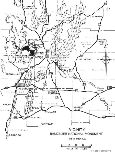
| Map 1. Bandelier National Monument vicinity. (click on image for an enlargement in a new window) |

|
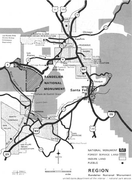
| Map 2. Bandelier National Monument region. (click on image for an enlargement in a new window) |
The earliest 20th century development in Frijoles Canyon was a small ranch known as Ten Elders, which belonged to a retired judge named Abbott. Mr. and Mrs. George Frey bought the ranch from the Abbotts in 1925 and turned it into a guest ranch. This ranch, located on the edge of Frijoles Creek near the Tyuonyi ruins, approximately 1/4 mile upstream from the current visitor center, afforded limited accommodations to canyon visitors. Early access to the canyon floor was via steep foot and horse trails more than a mile long opposite the ranch. A small tramway for supplies and the later 1930s entrance road opened the monument to a larger public. The subsequent need for expanded visitor services and the required park administrative and operational facilities led to construction of the building complex. Initiated in 1934, the growth of this complex continued over the next eight years, resulting finally in 31 buildings, which, to a large degree, have maintained their original functions. With the exception of interior partitions, color scheme, roofing, and utility modifications over the years, the buildings basically reflect their historic appearance.
The 31 buildings fall into four basic locational groupings: the headquarters, cabin, canyon, and entrance road areas. The only exception is the comfort station (B-1) in the Cottonwood picnic area, west of the headquarters area. The entrance road area contains the fire lookout (B-30) and entrance station (B-26), and the canyon area contains five residential units (B-7, B-8, B-10, B-1l, and B-32) and the park stables (B-25). The headquarters area contains eight service-oriented buildings (B-3, B-4, B-5, B-6, B-12, B-13, B-14, and B-22), the visitor center and museum (B-2), comfort station (B-9), administrative headquarters (B-15/6), curio shop and snack bar (B-17), and VIP quarters (B-18). These latter two buildings historically belong with the remaining eight buildings (the cabin area), because they are part of the complex originally built as the cabin and hotel development area. Today, three of these buildings (B-19, B-20, and B-28) are residential quarters, B-24 and B-27 are combination residential-office use, B-23 and B-29 are offices, and B-21 has been converted to a laundry and storage facility. Excluding the two entrance road structures, the overall complex encompasses approximately 8 acres.
This report is only one component of the current five-part Development/Study Package 224. Other components include rehabilitation of water, sewer, electrical, and gas services; rehabilitation of decaying wood structural members; rehabilitation of flagstone and curbing; and installation of insulated windows and fire alarm systems. These other four components are scheduled for design and construction over several years. Because of the intended focus of this historic structures report and subsequent construction work, the following findings and observations are based on class B investigations, as defined in part IV of National Park Service Professional Standards.
The basic format for this document is that of NPS-28, slightly modified for this project. The first section contains the administrative data. It is followed by a short narrative history of the buildings and a summary of their significance. Other sections include the physical history of the buildings, including site and building-specific data, a discussion of existing conditions, treatment recommendations, a framework for assessing accessibility and adaptive use issues, and recommendations for further study. An annotated bibliography is provided.

|
| Figure 1. This 1987 aerial photograph of the CCC building complex at Bandelier National Monument shows the majority of the stuctures and their layout around the central parking plaza. The structures are nestled into the narrow building site in Frijoles Canyon. The rito (creek) serves as the western edge, and the talus slopes of the canyon cliffs define the eastern edge. Some character-defining features of the pueble revival style are evident, including the courtyards, parapets, building masses, and terracing. |
| <<< Previous | <<< Contents >>> | Next >>> |
band/hsr/hsr1.htm
Last Updated: 08-May-2005